A largely unknown 4/27 fact.
This supercell nearly produced an intense tornado next to Virginia Tech at 1:30 AM on 4/28, but was cut off last second.
Unbelievably, this was the same cell that produced the Cordova EF4, the Rainsville EF5, and the Ringgold EF4 hours earlier.
This video of the 2011 EF5 Hackleburg tornado approaching Phil Campbell is one of the scariest things I’ve ever seen.
When you’re in the path of a wedge like this, the average person usually cannot recognize it as a tornado.
This is why. It’s just too big.
On this day in 2024, a strong tornado impacted the Eldersburg, Maryland area. The tornado was initially rated high-end EF1 with estimated winds of 110 mph. A year later, while reviewing the damage out of curiosity, I contacted the NWS about some of the tree damage, which appeared more consistent with EF2 intensity. They conducted a reanalysis of the event and, a week later, upgraded the tornado to low-end EF2 with estimated winds of 120 mph.
Hackleburg had a major debris ball (near 70 dBz) with a large TBSS right after it hit town.
High-resolution KGWX data existed on 4/27, but due to bandwidth limitations, only lower-resolution legacy data could be archived.
This NWS BMX loop is all we have of that lost data.
Here are some aerial photographs showing the tree damage caused by the prolific tree-eater Springfield, MA EF3 15 years ago today.
This event was by far the strongest in the region since 1953, and was actually more consistent than Worcester was IMO.
Based on data from NWS Norman's tornado table for Oklahoma tornadoes in 2026, NWS Tulsa has confirmed two tornadoes in Pushmataha and Choctaw County from May 27th. The Pushmataha County tornado near Antlers was rated EF-1. Oklahoma WILL have tornadoes in May 2026 after all. #OKwx
On this day in 2011:
A long-track, powerful tornado tore through Springfield, Monson, and Sturbridge, Massachusetts. Rated a high-end EF3, the tornado caused extensive tree damage and destroyed numerous homes. Based on the severity of the damage, it is believed the tornado may have reached EF4 intensity at times during its life.
On this day in 2013, one of the 21st century's most infamous tornadoes broke records and cut short the lives of some of the best in our field.
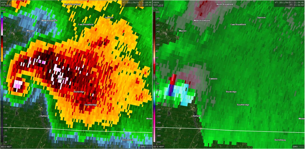
Here are a few radars' views of the El Reno, Oklahoma EF3:
1. KTLX
2. MPAR
3. RaXPol
4. TOKC
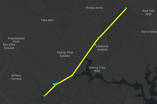
I just found an undocumented tornado scar from last year in China's Heilongjiang Province!
Date: 7/2/2025 at about 09:30 UTC
Movement Direction: ENE
Coordinates: 48.62207, 127.75238
Notes: Damage swath is very multivort and easily visible on Google Earth. Prob lower EF3.
On this day in 2019:
A violent, mile-wide, rain-wrapped EF4 tornado tore through Lawrence and Linwood, Kansas, causing severe damage to numerous homes and structures. One well-built home along Golden Road was completely destroyed and received a low-end EF4 rating, with estimated winds of 170 mph.
We recently conducted a storm survey and concluded that a short lived EF-1 tornado occurred on the night of May 26. The tornado touched down just east of Linne Road and continued tracking eastward toward FM 775 before eventually lifting near Sweet Home Road. #txwx
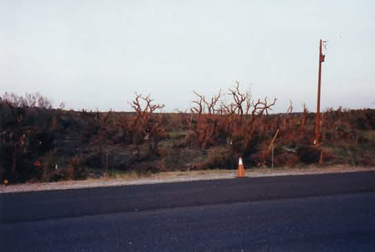
Damage pics I took in 1997 from the Pedernales Valley F4 tornado that hit Hwy 71/Hazy Hills on 5/27/1997.
- The tornado touched down on the S shore of Lake Travis, destroyed 15 homes, damaged 14 others.
- Max winds of 207 mph, tracked to the SW for 8 miles
Thanks to a surge in newly confirmed tornadoes today, May 2026 has limped across the finish line and reached at least 101 tornadoes for the month. The month will NOT be the least active May on record for tornadoes. 2026 overall is now up to 647 confirmed tornadoes. #WxTwitter
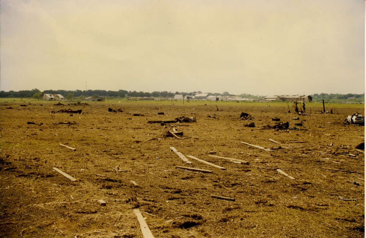
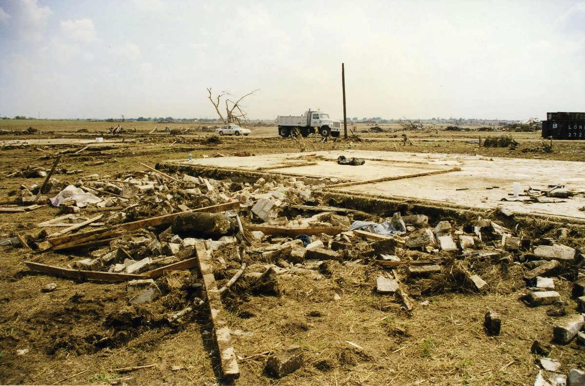
On this day in 1997:
An extremely violent F5 tornado moved southwest into the Jarrell, Texas area, devastating the Double Creek Estates subdivision. Homes were completely shredded and swept from their foundations, with severe ground scouring occurring throughout the area. Tragically, 27 people were killed.
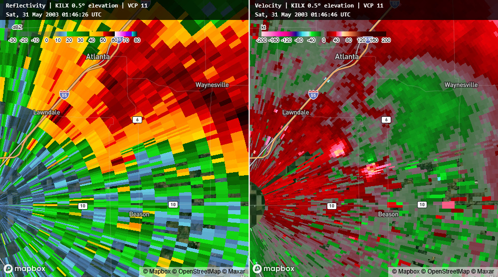
This has got to be one of the coolest tornado evolutions I’ve ever seen on radar. On May 30, 2003, a strong cyclonic tornado developed near Lincoln, Illinois. Then, behind it, an anticyclonic tornado formed, cut off the original tornado, and continued on its own path. Really fascinating evolution.