Patchy fog this morning in the south-east of the state. Showers continue along the east coast, mostly dry elsewhere.
Strong coastal winds north of Mackay.
Latest: https://t.co/pHBqOX6o1s
Isolated to scattered showers tomorrow in eastern districts, tending widespread at times on the North Tropical Coast and Sunshine Coast. Sunny in the west, mostly sunny elsewhere. Cloud may increase in the far southwest later in the day.
More: https://t.co/QYRYz5cIXN
National Weather Forecast: Windy, rainy in south-east. Cool day in west.
Video current: 3pm AEST Friday 12 June 2026.
Latest: https://t.co/4W35o8iFmh or the BOM Weather app.
🌦️Showers in eastern districts and the southern inland, most likely about the North Tropical Coast.
⛈️The chance of a thunderstorm about K'gari and the offshore Stradbroke and Moreton Islands in South East Queensland.
🌡️Temperatures mostly above average
https://t.co/4B5ukOXCcR
Isolated to scattered showers in eastern districts, tending widespread at times on the North Tropical Coast. The chance of a thunderstorm about K'gari and the offshore Stradbroke and Moreton Islands in South East Queensland.
More: https://t.co/QYRYz5cIXN
National Weather Forecast: Mild and gusty in the east. Rain approaching from the west. Video current: 1pm AEST Thursday 11 June 2026.
Latest forecasts and warnings: https://t.co/4W35o8iFmh or the BOM Weather app.
⛈️Showers, isolated thunderstorms, and periods of rain tomorrow in the #QLD southern and central interior
🌦️Showers about the coast, most likely for the North Tropical Coast
🌤️Mostly sunny in the west
🌡️Temperatures mostly above average
https://t.co/4B5ukOXCcR
Tomorrow's thunderstorm FORECAST
Storms are possible in the southern and central interior of Queensland tomorrow.
Isolated moderate falls are possible within these storms, but severe thunderstorms aren't currently on the forecast.
More: https://t.co/PbQu1YHGor
Scattered to widespread showers, isolated thunderstorms, and periods of rain tomorrow in the southern and central interior. Mostly sunny in the west, isolated to scattered showers elsewhere, tending widespread at times on the North Tropical Coast.
More: https://t.co/QYRYz5cIXN
National Weather Forecast: Rain and storms in the west & east. Heavy falls for WA. Video current: 2pm AEST Wednesday 10 June 2026.
Latest: https://t.co/4W35o8iFmh or the BOM Weather app.
⛈️Showers, isolated thunderstorms and periods of rain about the southern and central interior of #QLD today
🌦️Showers elsewhere, tending widespread at times on the North Tropical Coast
🌤️Mostly sunny in the northwest
🌡️Temperatures above average
https://t.co/4B5ukOXCcR
Showers, isolated thunderstorms and periods of rain tomorrow in the southern and central interior. Mostly sunny in the northwest, isolated to scattered showers elsewhere, tending widespread at times on the North Tropical Coast.
More: https://t.co/QYRYz5cIXN
🌦️Showers across much of #QLD today, most likely about parts of the east coast and the southwest
⛈️Possible isolated thunderstorms in the southwest
🌥️Dry and partly cloudy in the far west and northwest
🌡️Temperatures close to or above average
https://t.co/4B5ukOXCcR
Partly cloudy tomorrow north of Mount Isa to Richmond and west of Georgetown, with isolated to scattered showers elsewhere. Showers tending widespread at times along the South East coastal fringe, Central Coast and between Ingham and Innisfail.
More: https://t.co/QYRYz5cIXN
A cold and frosty start for inland parts of #Qld, but a sunny day to follow.
Cloud and isolated showers about the east coast.
More information: https://t.co/QYRYz5cIXN
🌤️Mostly sunny across much of #Queensland today
🌦️Showers around parts of the coast
🌡️Temperatures mostly close to or below average
https://t.co/4B5ukOXCcR
🌤️Mostly sunny across much of #Qld today
🌦️Isolated showers on the Granite Belt, and the far northeast coasts
🌬️Moderate to fresh and gusty west to southwesterly winds in the south, with possible damaging wind gusts about high terrain south of Gatton
https://t.co/4B5ukOXCcR
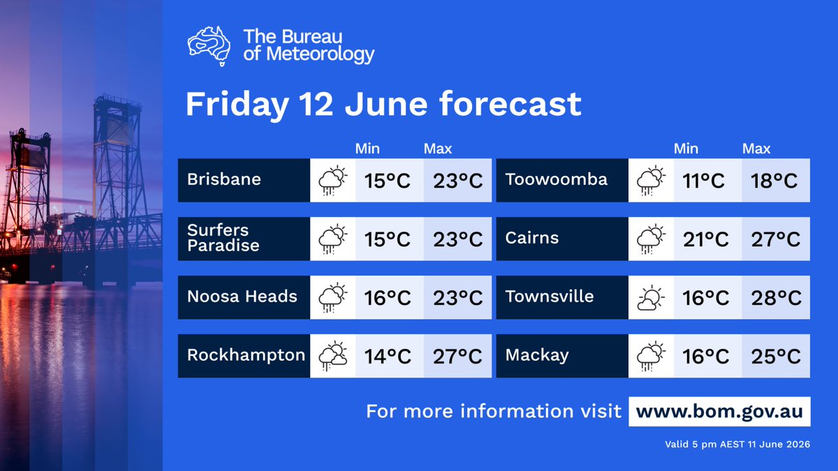
Friday forecast #Qld:
🌬️Strong west to southwesterly winds with possible damaging gusts on and in the lee of high terrain south of Gatton in the morning.
🌦️Isolated showers on the Granite Belt, the North Tropical Coast, and northern Cape York Peninsula.
https://t.co/4B5ukOXCcR
⚠️🌬️Severe Weather Warning for DAMAGING WINDS
parts of Southeast Coast and Darling Downs and Granite Belt Forecast Districts.
Damaging winds likely on the peaks and lee slopes of the Main Range early Friday morning.
https://t.co/9Ye194KBDr
Isolated showers tomorrow on the Granite Belt, the North Tropical Coast, and northern Cape York Peninsula. Partly cloudy in the southern interior, sunny elsewhere. Possible morning fog in eastern districts between Port Douglas and Ingham.
More: https://t.co/QYRYz5cIXN