Out and about tonight? Be sure to bundle up! Most of the region is in the teens and 20s currently, and by daybreak, higher terrain of the southern Poconos and NW Jersey could be in the single digits!
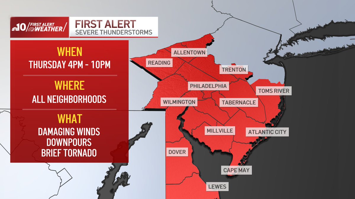
FIRST ALERT THURSDAY 9/25🚨
There will be showers and non-severe storms Thursday morning and early afternoon. Then - there's a risk of scattered severe storms from 4pm-10pm THU. for all of our neighborhoods.
This timeline may change, so stay with @NBCPhiladelphia for updates
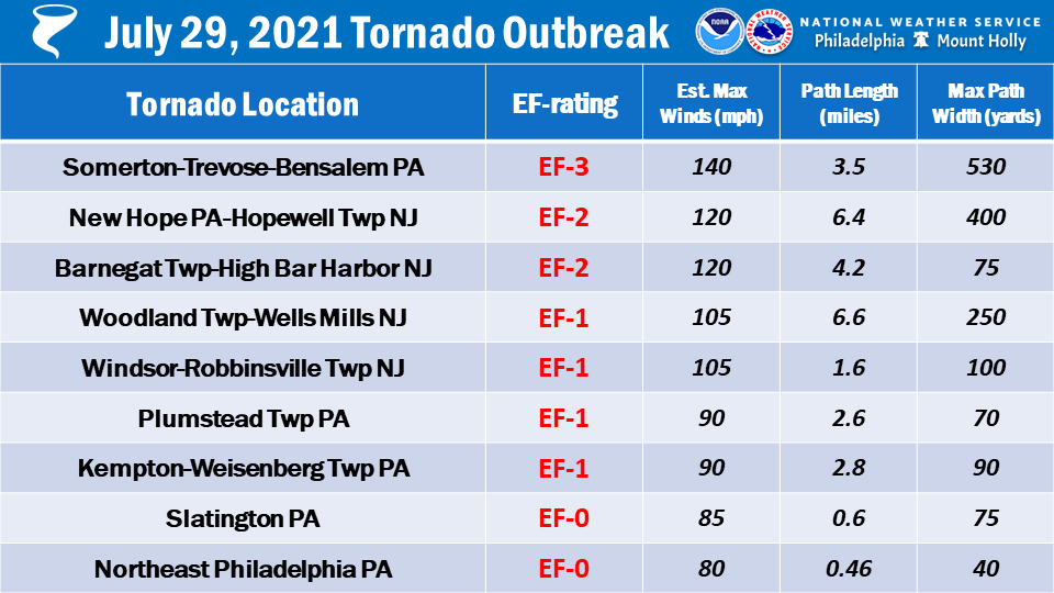
🌪️🗓️ On this day 4 years ago, 9 tornadoes impacted our area causing significant damage to portions of PA and NJ. This event would later be overshadowed by the tornado outbreak and catastrophic flash flooding caused by Hurricane Ida's remnants, which occurred just 34 days later.
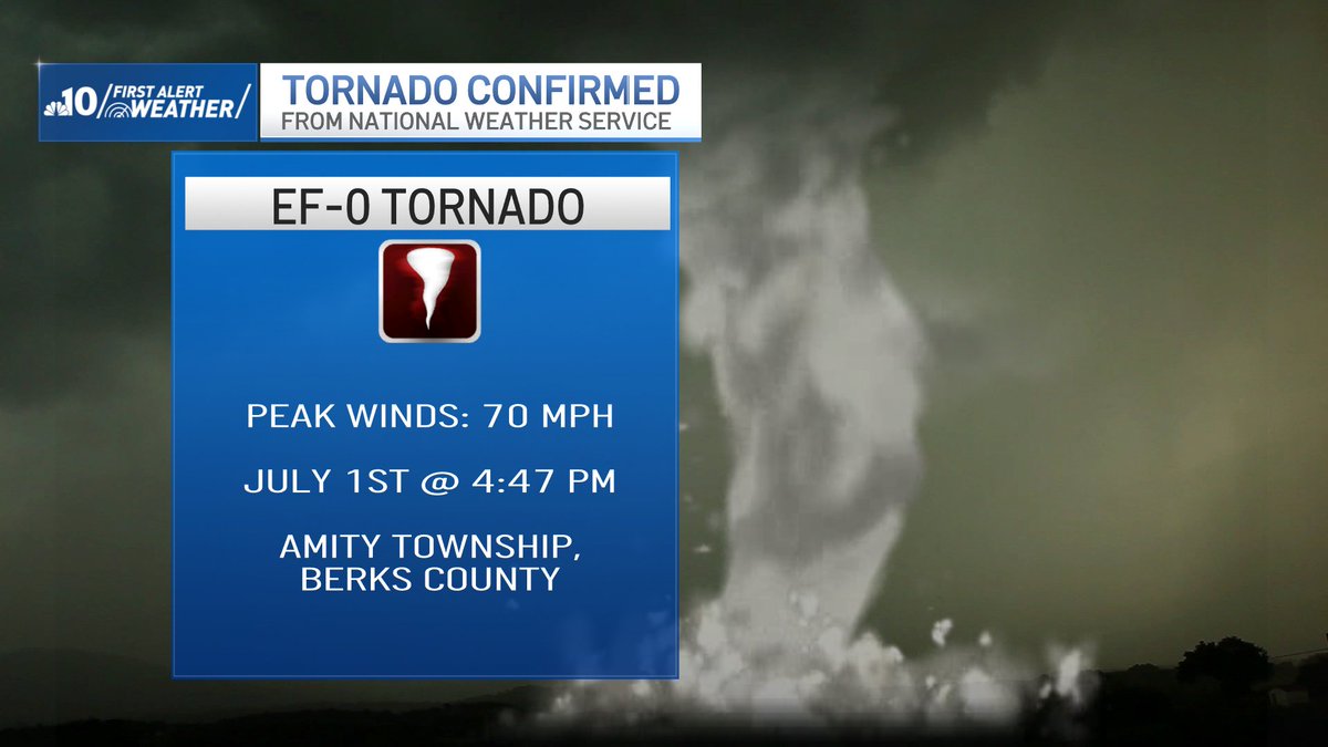
CONFIRMED TORNADO
The tornado-warned storm that @brittneyshipp & I tracked yesterday on @NBCPhiladelphia was an EF-0. The area of rotation broadened to straight-line winds up to 70mph near Boyertown. We will learn more information from @NWS_MountHolly later tonight or tomorrow
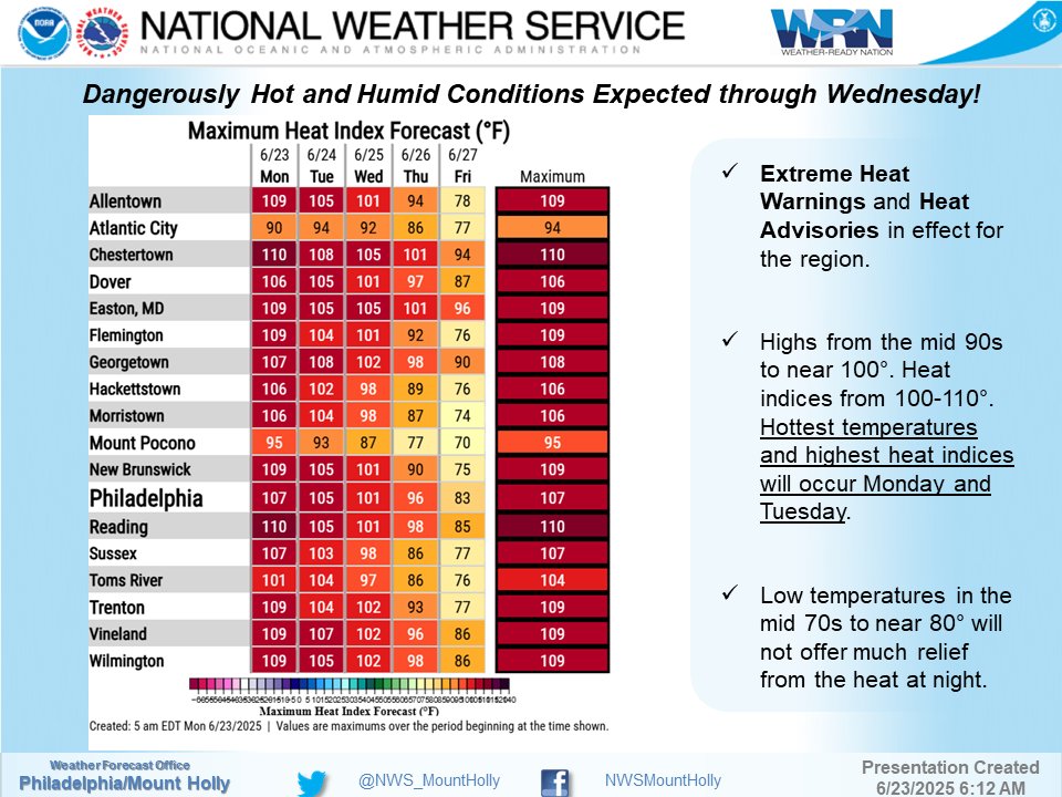
⚠️We simply cannot stress this enough: it will be dangerously hot the next three days.⚠️
🧊 Stay cool.
💧 Stay hydrated.
🛑 Limit strenuous outdoor activities.
👥 Check up on your relatives and neighbors.
❌ NEVER leave people or pets unattended in a car!
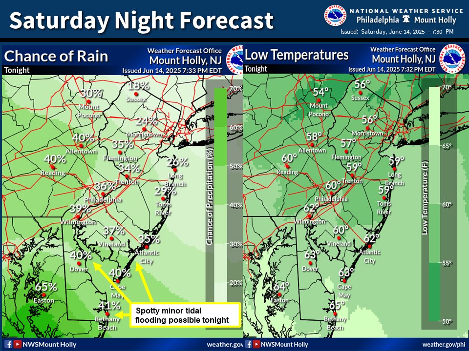
Mild tonight with some scattered showers around, mainly for areas south of Philadelphia. There is some potential for spotty minor tidal flooding for coastal South Jersey, Delaware, and communities along Delaware Bay.
For latest tidal forecasts, visit: https://t.co/90fQBZATCM
A Code Orange Air Quality Alert has been issued for Thursday. This is due to ozone pollution building with the heat. Sensitive groups need to take extra care tomorrow. Plus, our temperatures will soar to 91, our first 90 degree day since last August!
This map shows all of the tornado warnings issued today (red polygons) in DC region -- over a dozen. No twisters confirmed at this time but may happen over the weekend after damage is reviewed.
More info at https://t.co/O5ePGELlht
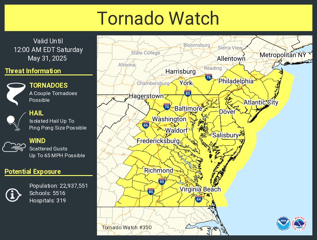
Tornado Watch now in place for much of our region until Midnight. A watch means we are watching the situation. A warning means take shelter. @NBCPhiladelphia
Have a look at this week's forecast:
Temperatures remain warm and mainly above average for mid-May throughout. However, conditions will be unsettled once high pressure gives way tonight.
Head to https://t.co/ka2HFv1cF3 for your local forecast details. #DEwx#MDwx#NJwx#PAwx
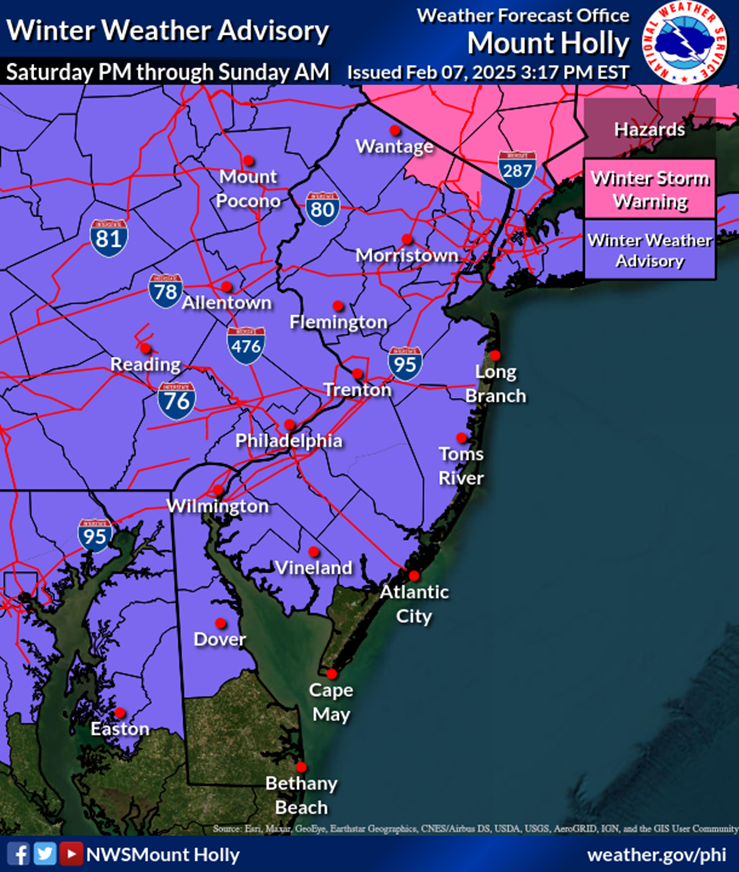
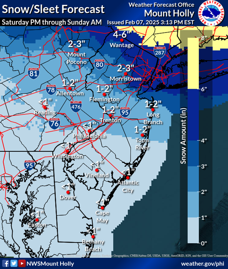
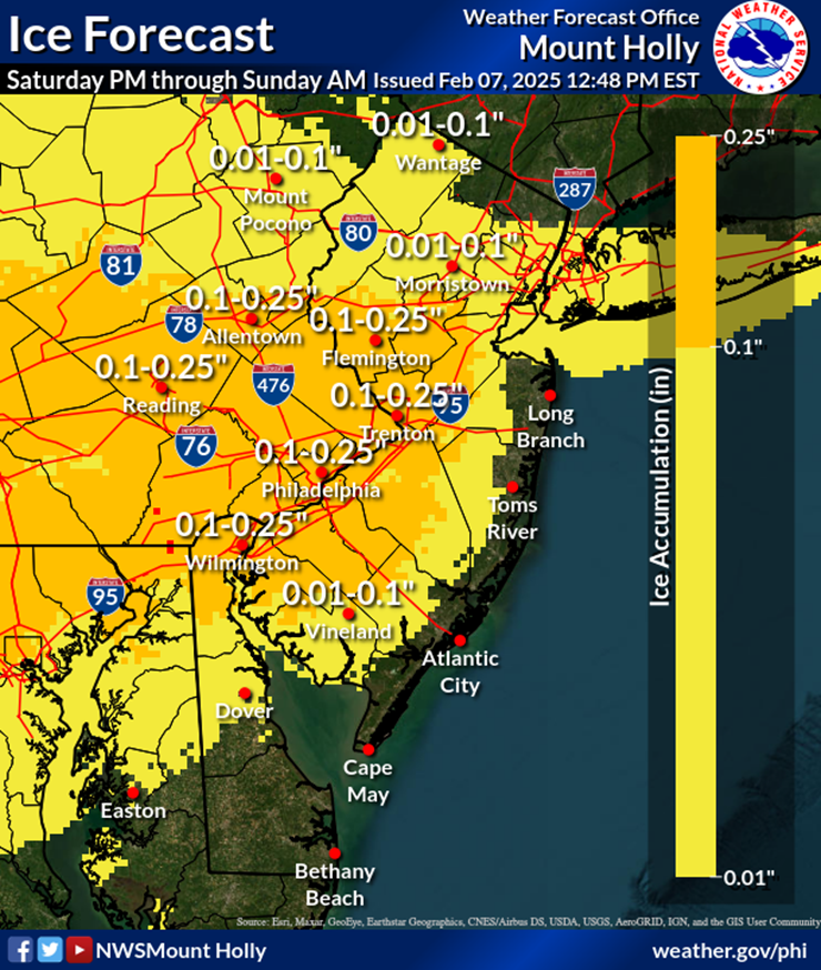
⚠️🧊❄️ No major changes to the forecast for Saturday afternoon into Saturday night. A Winter Weather Advisory has been issued for a large portion of the area, where icy and snowy roads could lead to hazardous travel. Latest briefing https://t.co/JiD09ByGTv #PAwx#NJwx#DEwx#MDwx
A book fair is set to take place this weekend in Center City and among the books featured at the event is a new one called “Drippity Drop The Rapping Raindrop” written by NBC10’s @brittneyshipp. @AunyeaLachelle got the chance to talk to her about the book. https://t.co/mZA3DwLv3a
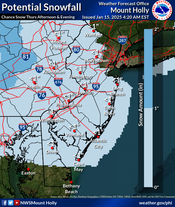
❄️ Confidence is increasing for some potential light snowfall occurring Thursday afternoon & evening within the highlighted areas. A dusting generally less than 1" is anticipated, although portions of E PA near/north of I-78 could end up in the 1-2" range. #PAwx#NJwx#DEwx#MDwx
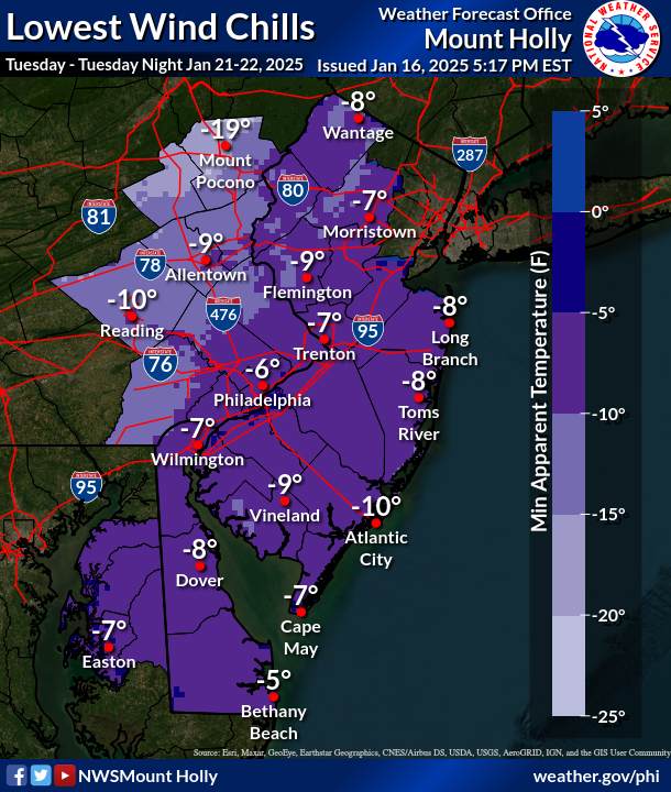
🥶🌬️ As the snowy system departs, cold and blustery will be the theme for the remainder of the week. Temperatures will remain at or below freezing until at least Friday along with winds gusting up to 40 mph at times. Single digit wind chills at night. #PAwx#NJwx#DEwx#MDwx
🎄❄️ You won't have to dream of a White Christmas this year if you're anywhere from near Trenton to the Lehigh Valley or north of there! A White Christmas is "officially" counted as 1" or more of snow depth at 7 AM Christmas morning. Here are some Christmas Day snow stats.