Happy Independence Day from all of us at Climavision!
Do you have plans to celebrate the United States of America's 250th anniversary? Let's take a look at the weather across the country as celebrations begin.
The west coast looks like the place to be with dry, comfortable weather from Seattle to Los Angeles. It will be perfect for daytime cookouts and nighttime fireworks.
The rest of the country will stay warm. The heat dome over the eastern U.S. remains bringing high temperatures and humidity levels, and the central US will see it all. While heat eases by the Great Lakes, storm chances increase.
The southern plains and southwest will remain hot and dry. If you're in either of those two areas, rethink plans for fireworks or use extreme caution.
Wherever you are celebrating Fourth of July this year, stay safe, stay hydrated, and have a great celebration!
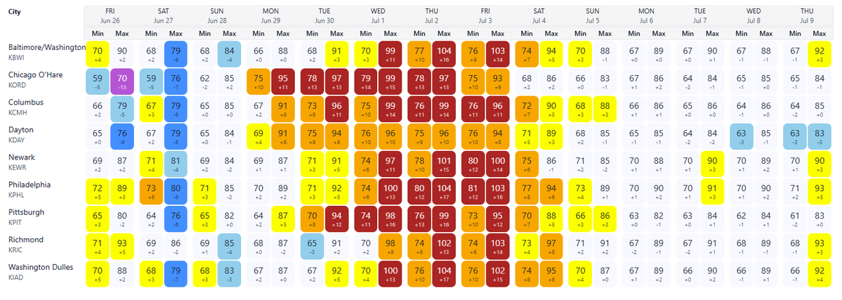
Natural gas desks beware: our cooler-than-normal weather pattern is about to shift to a heatwave in MISO and PJM starting next week. Climavision's Point Forecast System takes Minneapolis from the upper 70s to start the weekend to the upper 90s for Monday and Tuesday. Philadelphia sees temperatures surge from the 80s this weekend to near 100F by Wednesday. The close to 20F temperature increase over a large portion of the country will drive U.S. population-weighted cooling degree days up by close to 62%. The heat continues into the Independence Day holiday when load typically softens. Keep an eye out for stronger-than-normal power burn that may keep demand high when it normally lulls.
Image 1: Climavision PFS forecasted minimum and maximum temperature forecasts for cities in the PJM region.
Image 2: Climavision PFS forecasted minimum and maximum temperature forecasts for cities in the MISO region.
We are excited to announce our new partnership with @UofSouthAlabama! Through this academic partnership, we will provide proprietary radar data, guest lectures, and radar site visits to support instruction, research, and professional development. Read more in the official press release: https://t.co/JzRbVNo37s
Demand swings and generation disruptions are possible across MISO and SPP as severe weather moves through the region this week. This weather event is driven by a collision of warm and cool air masses that will shift consumption in impacted areas.
High winds, tornadoes, and hail all threaten power generation assets in the path of this system.
The comparison below shows how the NAM and Climavision's HI-RES are handling this event. Both capture the severe weather signal. The NAM retires on August 31st. Its replacement, the RRFS, has yet to be validated at scale by operational end users.
Now is the time to audit your weather stack. What replaces the NAM in your workflow?
#MISO #SPP #EnergyTrading #SevereWeather #Climavision #NAM
NOAA is retiring the NAM, SREF, and HREF on August 31 and replacing the models with the new RRFS and REFS systems. Workflows, thresholds, and model blends built around legacy products will need to be recalibrated as this is not a one-for-one swap.
But a model transition is also a good time to ask a broader question: what does your weather stack actually look like, and is it built for what you need?
NOAA's free modeling suite, old or new, is built for general public forecasting. It is not optimized for the location-specific, high-resolution decision support that energy traders, utilities, and commercial operators require.
That is where Climavision's HI-RES model fits. Running at 2 km resolution and built specifically for commercial applications, HI-RES is designed to give operators the edge that public models struggle to provide.
If your team is already doing the work of migrating away from legacy models, it is worth asking how improved data sources will improve your workflow.
On May 22, 2026, multiple tornados touched down across southwest Alabama, crossing National Weather Service forecasting boundaries and intensifying in an area where existing NEXRADs had limited low-level visibility.
This is exactly why Climavision built its gap-filling radar network.
As the storms moved through Alabama, Climavision’s V179 radar in Meridian, MS and V001 radar in Pine Hill, AL combined to offer a high-resolution view of storm development - a view that helped local, state, and federal partners and would not have been available from the public radar network alone.
The radars also detected tornado debris signatures for multiple tornados including the one from Marengo County, shown below. The high-resolution data helped forecasters detect the tornados and analyze their effects where survey crews could not reach.
When severe weather occurs in a gap, every observation matters. Climavision exists to ensure those critical moments don't go unseen.
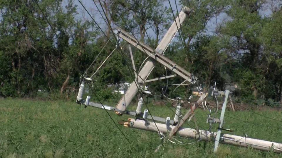
17,000 customers without power. That was the aftermath of Monday night’s severe thunderstorms across Kansas – 100+ mph wind gusts, widespread damage, and crews still working restoration across Saline County.
Climavision's HI-RES model predicted this event 48 hours in advance, which could have provided utility emergency response and outage management teams an earlier, more confident signal for crew staging and restoration prioritization.
Climavision is working with public agencies and local utilities to help them be more prepared for events like these.
Image 1: 48-hour forecasts from Climavision's HI-RES and the HRRR.
Image 2: Downed power lines resulting from the heavy winds. Image from KSN News.
Image 3: A semi-truck overturned by high winds. Image from KSN News.
In less than 90 days, NOAA will retire the NAM and other forecast models. RRFS, the replacement, has not been validated at scale by end users. For utility operators, public safety planners, and trading desks, testing matters.
Climavision's HI-RES is operational today with proven results. See how the models compare.
#RRFS #Climavision #WeatherForecasting
A Pacific low-pressure system is set to track across Texas beginning early Friday morning. Local rainfall totals could exceed 2" in South Texas and 5" in North Texas.
Climavision's HI-RES model is tracking the system and offers a high-resolution look at the potential threats out to 7 days. Much of this rain will fall in a short period of time as the storms move over the state, which could create dangerous flash floods and covered roadways.
With 2-km resolution and hourly forecast intervals out 7 days, HI-RES gives decision-makers a precise, early look at potential impact timing and location across the state.
Flash floods develop quickly and are hyper-local. The earlier you have high-confidence and high-resolution guidance on where the heaviest rain will be focused, the more lead time you have to prepare.
We'll be at Commodities Trading Week Americas in Stamford, CT on June 17 and 18 with @Commodities_Ppl!
Weather is one of the most difficult variables to model accurately in commodities markets, and the gap between what public forecast models can resolve and what trading desks actually need is widening.
Drop us a message if you want to connect and learn how Climavision's forecast models give your trading desk an edge.
#CTWA #Commodities #EnergyTrading #WeatherRisk
At what temperature do you open your windows and turn off your thermostat?
For most people, the 60s and low 70s feel like saving money. No heating, no cooling, just fresh air. But temperature alone doesn't dictate behavior.
When the dew point approaches the air temperature, what felt like fresh air begins to feel sticky and muggy. Moisture creates discomfort, and discomfort drives load. Utility customers flip on their AC not because it's hot, but because it's humid. These muggy conditions are becoming increasingly common in the overnight and early morning hours.
As the landscape of federal modeling resources shifts, the ability to resolve nuanced atmospheric variables is valuable for accurate energy demand forecasting.
The forecast below shows exactly this scenario: a temperature field that looks benign, and a dew point field that tells a different story.
What variables do you find most underweighted in the demand models you work with?
@cantnot Hi, local news stations, public safety offices, and the NWS offices have access to our radar network in North Carolina. Our data is used for public safety and for warnings/alerts during severe weather.
Severe weather recently moved through a critical FL radar gap with funnel clouds and damaging winds. The NWS is surveying multiple areas. Our radar network frequently captures weather that may go unseen by traditional coverage. We're excited to come to FL https://t.co/IJWJvWYY1l
NOAA is discontinuing parts of their high resolution modeling suite including the NAM & HREF on 8/31/26...102 days from now. Climavision’s product suite, though, was built for continuity. How can tools like Climavision’s HI-RES temperature anomaly forecast help your desk prepare?
We are excited to announce our partnership with @PennState Meteorology & Atmospheric Science! 🌩️
Our new partnership provides gap-filling weather radar data to Penn State's classroom and research efforts.
Read more here: https://t.co/WaSzubt5cA
Experts shared radar blind spots across southern Florida could delay life-saving weather alerts. Increasingly volatile weather and new solutions, like Climavision's gap-filling weather radars, make this issue a high priority with an actionable plan. @WPTV https://t.co/LAcN7LbhSI
Weather can dictate how and where we choose to spend our time before it even forms, and nearly everyone checks the weather to plan for their day, week, or next trip. Now, consider checking the weather and planning the day for 500,000 people. Read more: https://t.co/y33n38JGLr
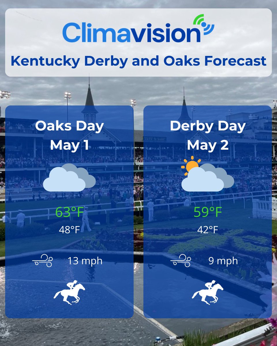
The biggest weekend of the year has arrived in Kentucky. Let's take a look at the weather for the 152nd running of The Kentucky Oaks and Derby courtesy of Climavision's Point Forecast System. Clouds, light winds, moderate temperatures, and dry conditions create a fast track.