TROPICAL CYCLONE BULLETIN NR. 14F
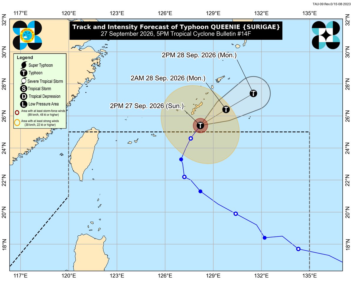
Typhoon #QueeniePH (SURIGAE)
Issued at 5:00 PM, 27 September 2026
QUEENIE HAS EXITED THE PHILIPPINE AREA OF RESPONSIBILITY.
DOST-PAGASA
Link: https://t.co/DFr8vgZGqn
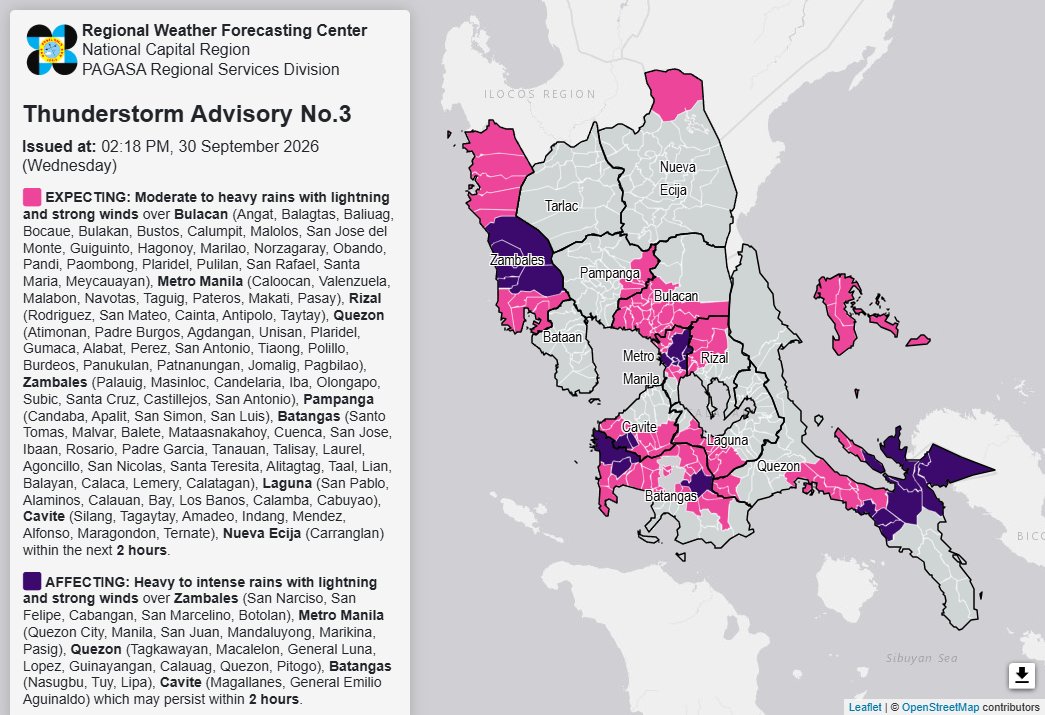
Thunderstorm Advisory No. 3 #NCR_PRSD
Issued at: 2:18 PM, 30 September 2026(Wednesday)
Moderate to heavy rainshowers with lightning and strong winds are expected over Batangas (Santo Tomas, Malvar, Balete, Mataasnakahoy, Cuenca, San Jose, Ibaan, Rosario, Padre Garcia, Tanauan, Talisay, Laurel, Agoncillo, San Nicolas, Santa Teresita, Alitagtag, Taal, Lian, Balayan, Calaca, Lemery, and Calatagan), Bulacan (Angat, Balagtas, Baliuag, Bocaue, Bulakan, Bustos, Calumpit, Malolos, San Jose del Monte, Guiguinto, Hagonoy, Marilao, Norzagaray, Obando, Pandi, Paombong, Plaridel, Pulilan, San Rafael, Santa Maria, and Meycauayan), Cavite (Silang, Tagaytay, Amadeo, Indang, Mendez, Alfonso, Maragondon, and Ternate), Laguna (San Pablo, Alaminos, Calauan, Bay, Los Banos, Calamba, and Cabuyao), Metro Manila (Caloocan, Valenzuela, Malabon, Navotas, Taguig, Pateros, Makati, and Pasay), Nueva Ecija (Carranglan), Pampanga (Candaba, Apalit, San Simon, and San Luis), Quezon (Atimonan, Padre Burgos, Agdangan, Unisan, Plaridel, Gumaca, Alabat, Perez, San Antonio, Tiaong, Polillo, Burdeos, Panukulan, Patnanungan, Jomalig, and Pagbilao), Rizal (Rodriguez, San Mateo, Cainta, Antipolo, and Taytay), and Zambales (Palauig, Masinloc, Candelaria, Iba, Olongapo, Subic, Santa Cruz, Castillejos, and San Antonio) within the next 2 hours.
Heavy to intense rainshowers with lightning and strong winds are affecting Batangas (Nasugbu, Tuy, and Lipa), Cavite (Magallanes and General Emilio Aguinaldo), Metro Manila (Quezon City, Manila, San Juan, Mandaluyong, Marikina, and Pasig), Quezon (Tagkawayan, Macalelon, General Luna, Lopez, Guinayangan, Calauag, Quezon, and Pitogo), and Zambales (San Narciso, San Felipe, Cabangan, San Marcelino, and Botolan) which may persist within 2 hours.
All are advised to take precautionary measures against the impacts associated with these hazards which include flash floods and landslides.
Keep monitoring for updates.
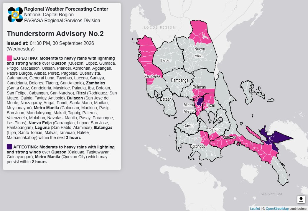
Thunderstorm Advisory No. 2 #NCR_PRSD
Issued at: 1:30 PM, 30 September 2026(Wednesday)
Moderate to heavy rainshowers with lightning and strong winds are expected over Batangas (Lipa, Santo Tomas, Malvar, Tanauan, Balete, and Mataasnakahoy), Bulacan (San Jose del Monte, Norzagaray, Angat, Pandi, Santa Maria, Marilao, and Meycauayan), Laguna (San Pablo and Alaminos), Metro Manila (Caloocan, Marikina, Pasig, San Juan, Mandaluyong, Makati, Taguig, Pateros, Valenzuela, Malabon, Navotas, Manila, Pasay, Paranaque, and Las Pinas), Nueva Ecija (Carranglan, Lupao, San Jose, and Pantabangan), Quezon (Quezon, Lopez, Gumaca, Pitogo, Macalelon, Unisan, Plaridel, Atimonan, Agdangan, Padre Burgos, Alabat, Perez, Pagbilao, Buenavista, Catanauan, General Luna, Tayabas, Lucena, Sariaya, Candelaria, Dolores, Tiaong, and San Antonio), Rizal (Rodriguez, San Mateo, Cainta, Taytay, and Antipolo), and Zambales (Santa Cruz, Candelaria, Masinloc, Palauig, Iba, Botolan, San Felipe, Cabangan, and San Narciso) within the next 2 hours.
The above condition is affecting Metro Manila (Quezon City) and Quezon (Calauag, Tagkawayan, and Guinayangan) which may persist within 2 hours.
All are advised to take precautionary measures against the impacts associated with these hazards which include flash floods and landslides.
Keep monitoring for updates.
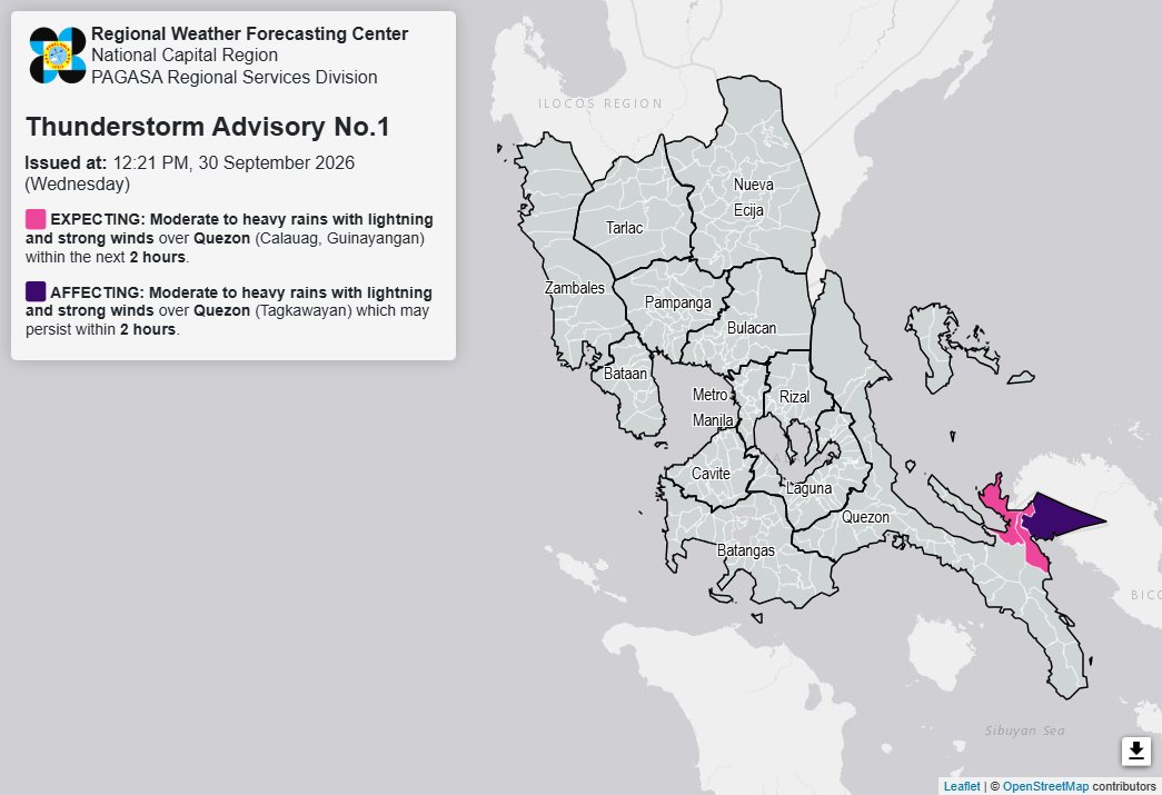
Thunderstorm Advisory No. 1 #NCR_PRSD
Issued at: 12:21 PM, 30 September 2026(Wednesday)
Moderate to heavy rainshowers with lightning and strong winds are expected over Quezon (Calauag and Guinayangan) within the next 2 hours.
The above condition is affecting Quezon (Tagkawayan) which may persist within 2 hours.
All are advised to take precautionary measures against the impacts associated with these hazards which include flash floods and landslides.
Keep monitoring for updates.
Thunderstorm Watch #NCR_PRSD
Issued at: 10:00 AM, 30 September 2026
Thunderstorm is MORE LIKELY to develop over Greater Metro Manila Area(Metro Manila, Bulacan, Rizal, Laguna and Cavite) within 12 hours.
All are advised to continue monitoring for updates.
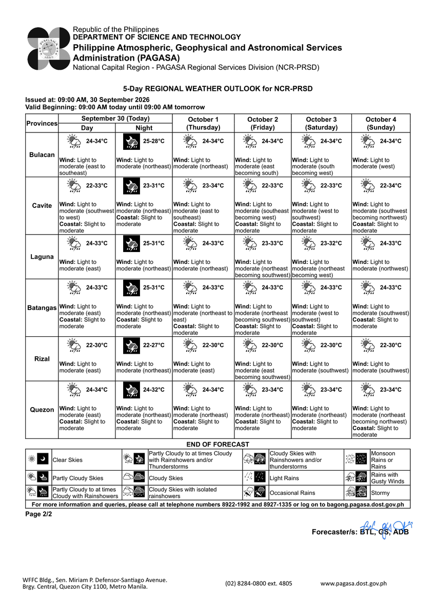
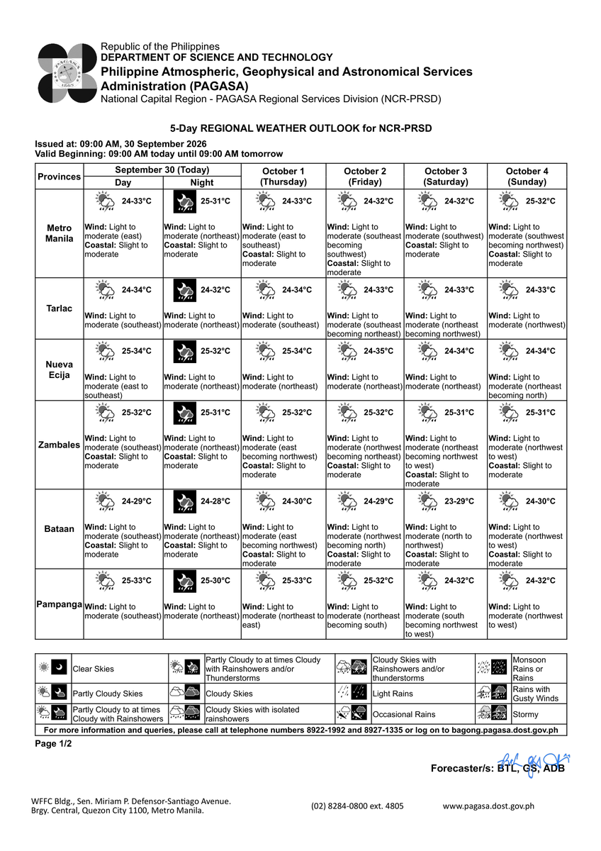
5-DAY REGIONAL WEATHER OUTLOOK for #NCR_PRSD
Issued at: 9:00 AM, 30 September 2026
Valid Beginning: 9:00 AM today - 9:00 AM tomorrow
https://t.co/FgzeJ2NtSQ
***Help us improve our service by answering this quick survey.
Kindly follow this link: https://t.co/qnRqQ9kVj7
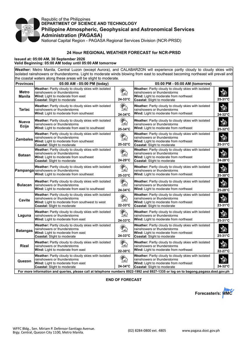
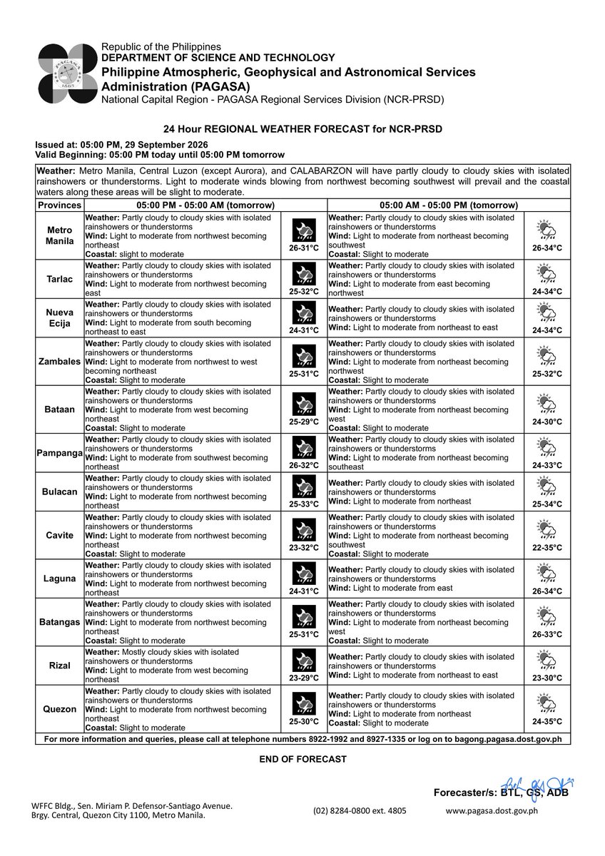
REGIONAL WEATHER FORECAST for #NCR_PRSD
Issued at: 5:00 AM, 30 September 2026
Valid Beginning: 5:00 AM today - 5:00 AM tomorrow
https://t.co/FgzeJ2NtSQ
***Help us improve our service by answering this quick survey.
Kindly follow this link: https://t.co/qnRqQ9kVj7
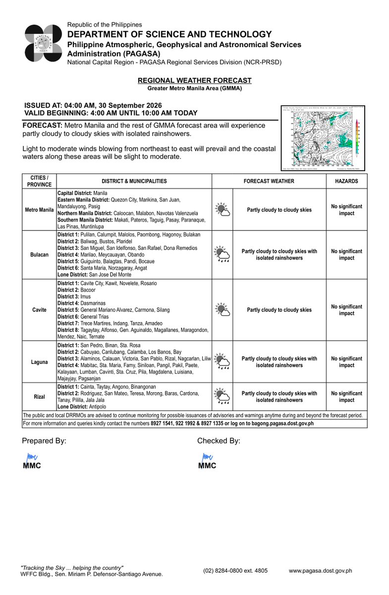
REGIONAL WEATHER FORECAST for GREATER METRO MANILA AREA (GMMA) #NCR_PRSD
Issued at: 4:00 AM, 30 September 2026
Valid Beginning: 4:00 AM - 10:00 AM today
https://t.co/FgzeJ2NtSQ
Thunderstorm Advisory No. 10 #NCR_PRSD
Issued at: 8:20 PM, 29 September 2026(Tuesday)
Heavy to intense rainshowers with lightning and strong winds are expected over Bataan (Orani, Samal, Abucay, Balanga, Hermosa, and Pilar), Bulacan (Hagonoy), Nueva Ecija (Pantabangan, Bongabon, Gabaldon, Laur, Rizal, Lupao, San Jose, General Tinio, and Palayan), Pampanga (Masantol, Macabebe, Sasmuan, Lubao, Mabalacat, Angeles, and Porac), Quezon (San Narciso, San Andres, San Francisco, Mulanay, Buenavista, Catanauan, Guinayangan, Tagkawayan, and General Nakar), and Tarlac (Bamban) within the next 2 hours.
Moderate to heavy rainshowers with lightning and strong winds are affecting Nueva Ecija (Carranglan) which may persist within 2 hours.
All are advised to take precautionary measures against the impacts associated with these hazards which include flash floods and landslides.
Keep monitoring for updates.
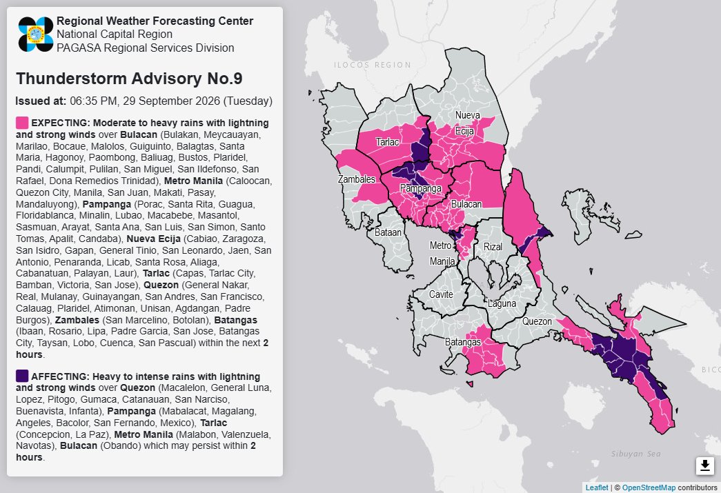
Thunderstorm Advisory No. 9 #NCR_PRSD
Issued at: 6:35 PM, 29 September 2026(Tuesday)
Moderate to heavy rainshowers with lightning and strong winds are expected over Batangas (Ibaan, Rosario, Lipa, Padre Garcia, San Jose, Batangas City, Taysan, Lobo, Cuenca, and San Pascual), Bulacan (Bulakan, Meycauayan, Marilao, Bocaue, Malolos, Guiguinto, Balagtas, Santa Maria, Hagonoy, Paombong, Baliuag, Bustos, Plaridel, Pandi, Calumpit, Pulilan, San Miguel, San Ildefonso, San Rafael, and Dona Remedios Trinidad), Metro Manila (Caloocan, Quezon City, Manila, San Juan, Makati, Pasay, and Mandaluyong), Nueva Ecija (Cabiao, Zaragoza, San Isidro, Gapan, General Tinio, San Leonardo, Jaen, San Antonio, Penaranda, Licab, Santa Rosa, Aliaga, Cabanatuan, Palayan, and Laur), Pampanga (Porac, Santa Rita, Guagua, Floridablanca, Minalin, Lubao, Macabebe, Masantol, Sasmuan, Arayat, Santa Ana, San Luis, San Simon, Santo Tomas, Apalit, and Candaba), Quezon (General Nakar, Real, Mulanay, Guinayangan, San Andres, San Francisco, Calauag, Plaridel, Atimonan, Unisan, Agdangan, and Padre Burgos), Tarlac (Capas, Tarlac City, Bamban, Victoria, and San Jose), and Zambales (San Marcelino and Botolan) within the next 2 hours.
Heavy to intense rainshowers with lightning and strong winds are affecting Bulacan (Obando), Metro Manila (Malabon, Valenzuela, and Navotas), Pampanga (Mabalacat, Magalang, Angeles, Bacolor, San Fernando, and Mexico), Quezon (Macalelon, General Luna, Lopez, Pitogo, Gumaca, Catanauan, San Narciso, Buenavista, and Infanta), and Tarlac (Concepcion and La Paz) which may persist within 2 hours.
All are advised to take precautionary measures against the impacts associated with these hazards which include flash floods and landslides.
Keep monitoring for updates.
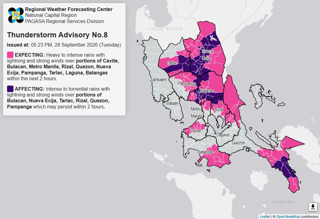
Thunderstorm Advisory No. 8 #NCR_PRSD
Issued at: 5:23 PM, 29 September 2026(Tuesday)
Heavy to intense rainshowers with lightning and strong winds are expected over Batangas (San Jose, Ibaan, Rosario, Batangas City, Taysan, Lobo, San Juan, Padre Garcia, Lipa, San Pascual, Bauan, Mabini, Alitagtag, and Cuenca), Bulacan (Malolos, Calumpit, Paombong, Hagonoy, Meycauayan, Marilao, Obando, San Rafael, Dona Remedios Trinidad, and San Ildefonso), Cavite (General Trias, Dasmarinas, Trece Martires, Tanza, Naic, Maragondon, and Ternate), Laguna (Santa Maria, Famy, Siniloan, Pangil, Pakil, and Mabitac), Metro Manila (Caloocan, Valenzuela, Malabon, Navotas, Quezon City, San Juan, and Marikina), Nueva Ecija (Carranglan, Lupao, Munoz, Santo Domingo, Quezon, Licab, Bongabon, Laur, Palayan, Penaranda, General Tinio, Gabaldon, Guimba, Cuyapo, Nampicuan, and Talugtug), Pampanga (Magalang, Arayat, San Luis, San Simon, Apalit, Santa Ana, Mexico, San Fernando, Bacolor, Angeles, Mabalacat, Santo Tomas, and Minalin), Quezon (General Nakar, Guinayangan, Lopez, General Luna, San Francisco, San Andres, Infanta, Real, Tagkawayan, Macalelon, Gumaca, Pitogo, Unisan, and Plaridel), Rizal (San Mateo, Antipolo, and Tanay), and Tarlac (Bamban, San Jose, Gerona, Victoria, and Pura) within the next 2 hours.
Intense to torrential rainshowers with lightning and strong winds are affecting Bulacan (Angat, Pandi, Bustos, Plaridel, Guiguinto, Balagtas, Santa Maria, San Jose del Monte, Bocaue, Norzagaray, Bulakan, Pulilan, Baliuag, and San Miguel), Nueva Ecija (San Isidro, Jaen, Santa Rosa, Zaragoza, Pantabangan, Rizal, General Mamerto Natividad, Cabanatuan, Aliaga, Talavera, Llanera, San Jose, San Antonio, Cabiao, Gapan, and San Leonardo), Pampanga (Candaba), Quezon (Mulanay, Buenavista, San Narciso, and Catanauan), Rizal (Rodriguez), and Tarlac (La Paz, Tarlac City, Concepcion, and Capas) which may persist within 2 hours.
All are advised to take precautionary measures against the impacts associated with these hazards which include flash floods and landslides.
Keep monitoring for updates.
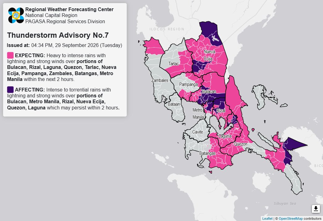
Thunderstorm Advisory No. 7 #NCR_PRSD
Issued at: 4:34 PM, 29 September 2026(Tuesday)
Heavy to intense rainshowers with lightning and strong winds are expected over Batangas (San Juan, Lobo, Batangas City, Ibaan, Taysan, San Jose, San Pascual, Alitagtag, Lipa, Rosario, Padre Garcia, Santo Tomas, Malvar, Balete, Mataasnakahoy, Cuenca, and Tanauan), Bulacan (Baliuag, Calumpit, Malolos, Dona Remedios Trinidad, Hagonoy, Paombong, Plaridel, Pulilan, San Ildefonso, and San Miguel), Laguna (Mabitac, Santa Maria, Kalayaan, Paete, Lumban, Cavinti, San Pablo, Alaminos, Bay, Calauan, Liliw, Los Banos, Luisiana, Magdalena, Majayjay, Nagcarlan, Pagsanjan, Pila, Rizal, Santa Cruz, Victoria, and Calamba), Metro Manila (Valenzuela, Malabon, Navotas, Marikina, San Juan, Manila, Mandaluyong, and Pasig), Nueva Ecija (Cabiao, Licab, Gapan, General Tinio, San Isidro, Aliaga, Bongabon, Cabanatuan, Cuyapo, Gabaldon, General Mamerto Natividad, Guimba, Laur, Llanera, Lupao, Nampicuan, Palayan, Penaranda, Quezon, Rizal, San Jose, Santo Domingo, Munoz, Talavera, and Talugtug), Pampanga (Arayat, Masantol, Macabebe, Sasmuan, Lubao, Candaba, and Magalang), Quezon (Mauban, Real, Lucena, Sariaya, Tayabas, Candelaria, Lucban, Sampaloc, Dolores, Tiaong, San Antonio, Infanta, General Nakar, Calauag, Lopez, Catanauan, General Luna, Macalelon, Pitogo, and Gumaca), Rizal (San Mateo, Tanay, Angono, Baras, Binangonan, Cainta, Cardona, Jala-Jala, Morong, Pililla, Taytay, and Teresa), Tarlac (La Paz, Concepcion, Tarlac City, Capas, Bamban, Victoria, Gerona, and Pura), and Zambales (Candelaria and Santa Cruz) within the next 2 hours.
Intense to torrential rainshowers with lightning and strong winds are affecting Bulacan (Bulakan, Angat, Balagtas, Bocaue, Bustos, Meycauayan, San Jose del Monte, Guiguinto, Marilao, Norzagaray, Obando, Pandi, San Rafael, and Santa Maria), Laguna (Pakil, Pangil, Siniloan, and Famy), Metro Manila (Quezon City and Caloocan), Nueva Ecija (Carranglan, Pantabangan, Santa Rosa, Jaen, San Leonardo, San Antonio, and Zaragoza), Quezon (Tagkawayan, Buenavista, and Guinayangan), and Rizal (Rodriguez and Antipolo) which may persist within 2 hours.
All are advised to take precautionary measures against the impacts associated with these hazards which include flash floods and landslides.
Keep monitoring for updates.
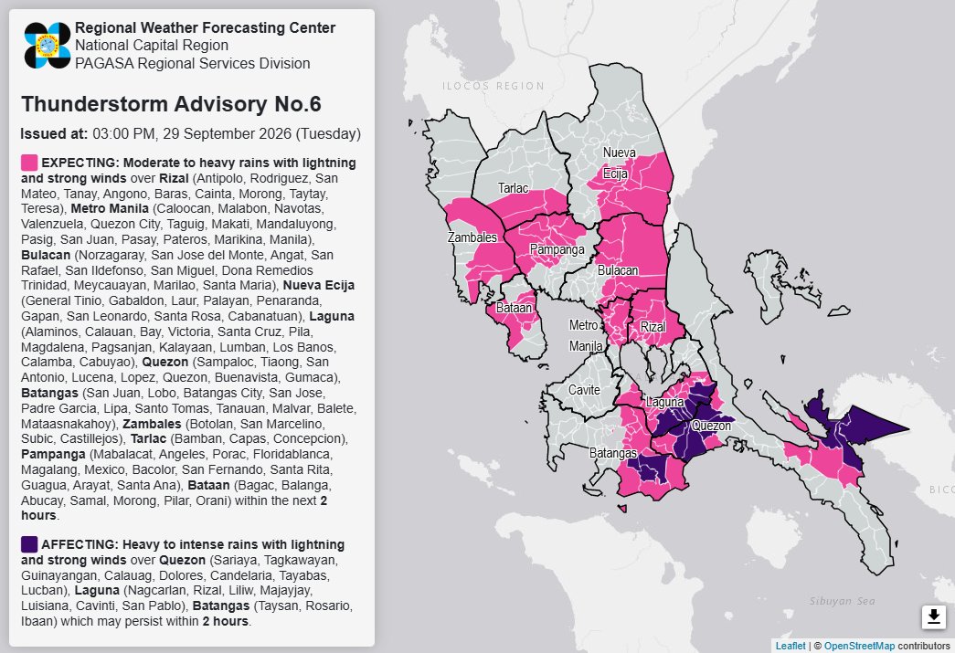
Thunderstorm Advisory No. 6 #NCR_PRSD
Issued at: 3:00 PM, 29 September 2026(Tuesday)
Moderate to heavy rainshowers with lightning and strong winds are expected over Bataan (Bagac, Balanga, Abucay, Samal, Morong, Pilar, and Orani), Batangas (San Juan, Lobo, Batangas City, San Jose, Padre Garcia, Lipa, Santo Tomas, Tanauan, Malvar, Balete, and Mataasnakahoy), Bulacan (Norzagaray, San Jose del Monte, Angat, San Rafael, San Ildefonso, San Miguel, Dona Remedios Trinidad, Meycauayan, Marilao, and Santa Maria), Laguna (Alaminos, Calauan, Bay, Victoria, Santa Cruz, Pila, Magdalena, Pagsanjan, Kalayaan, Lumban, Los Banos, Calamba, and Cabuyao), Metro Manila (Caloocan, Malabon, Navotas, Valenzuela, Quezon City, Taguig, Makati, Mandaluyong, Pasig, San Juan, Pasay, Pateros, Marikina, and Manila), Nueva Ecija (General Tinio, Gabaldon, Laur, Palayan, Penaranda, Gapan, San Leonardo, Santa Rosa, and Cabanatuan), Pampanga (Mabalacat, Angeles, Porac, Floridablanca, Magalang, Mexico, Bacolor, San Fernando, Santa Rita, Guagua, Arayat, and Santa Ana), Quezon (Sampaloc, Tiaong, San Antonio, Lucena, Lopez, Quezon, Buenavista, and Gumaca), Rizal (Antipolo, Rodriguez, San Mateo, Tanay, Angono, Baras, Cainta, Morong, Taytay, and Teresa), Tarlac (Bamban, Capas, and Concepcion), and Zambales (Botolan, San Marcelino, Subic, and Castillejos) within the next 2 hours.
Heavy to intense rainshowers with lightning and strong winds are affecting Batangas (Taysan, Rosario, and Ibaan), Laguna (Nagcarlan, Rizal, Liliw, Majayjay, Luisiana, Cavinti, and San Pablo), and Quezon (Sariaya, Tagkawayan, Guinayangan, Calauag, Dolores, Candelaria, Tayabas, and Lucban) which may persist within 2 hours.
All are advised to take precautionary measures against the impacts associated with these hazards which include flash floods and landslides.
Keep monitoring for updates.
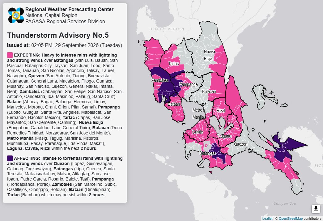
Thunderstorm Advisory No. 5 #NCR_PRSD
Issued at: 2:05 PM, 29 September 2026(Tuesday)
Heavy to intense rainshowers with lightning and strong winds are expected over Bataan (Abucay, Bagac, Balanga, Hermosa, Limay, Mariveles, Morong, Orani, Orion, Pilar, and Samal), Batangas (San Luis, Bauan, San Pascual, Batangas City, Taysan, San Juan, Lobo, Santo Tomas, Tanauan, San Nicolas, Agoncillo, Talisay, Laurel, and Nasugbu), Bulacan (Dona Remedios Trinidad, Norzagaray, and San Jose del Monte), Metro Manila (Pasig, Taguig, Marikina, Pateros, Muntinlupa, Pasay, Paranaque, Las Pinas, and Makati), Nueva Ecija (Bongabon, Gabaldon, Laur, and General Tinio), Pampanga (Lubao, Guagua, Santa Rita, Angeles, Mabalacat, San Fernando, Bacolor, and Mexico), Quezon (San Antonio, Tiaong, Buenavista, Catanauan, General Luna, Macalelon, Pitogo, Gumaca, Mulanay, San Narciso, Quezon, General Nakar, Infanta, and Real), Tarlac (Capas, San Jose, Mayantoc, San Clemente, and Camiling), Zambales (Cabangan, San Felipe, San Narciso, San Antonio, Candelaria, Iba, Masinloc, Palauig, and Santa Cruz), Cavite, Laguna, and Rizal within the next 2 hours.
Intense to torrential rainshowers with lightning and strong winds are affecting Bataan (Dinalupihan), Batangas (Lipa, Cuenca, Santa Teresita, Mataasnakahoy, Malvar, Alitagtag, San Jose, Ibaan, Padre Garcia, Rosario, Balete, and Taal), Pampanga (Floridablanca and Porac), Quezon (Lopez, Guinayangan, Calauag, and Tagkawayan), Tarlac (Bamban), and Zambales (San Marcelino, Subic, Castillejos, Olongapo, and Botolan) which may persist within 2 hours.
All are advised to take precautionary measures against the impacts associated with these hazards which include flash floods and landslides.
Keep monitoring for updates.
Thunderstorm Advisory No. 4 #NCR_PRSD
Issued at: 1:04 PM, 29 September 2026(Tuesday)
Heavy to intense rainshowers with lightning and strong winds are expected over Bataan (Abucay, Bagac, Balanga, Limay, Mariveles, Morong, Orion, Pilar, and Samal), Batangas (Tanauan, San Nicolas, Agoncillo, Lemery, Calaca, Calatagan, Balayan, Lian, Tuy, and Taal), Bulacan (Dona Remedios Trinidad, Norzagaray, and San Jose del Monte), Cavite (Bacoor), Laguna (San Pedro, Binan, Santa Rosa, Cabuyao, Calamba, Kalayaan, Paete, Pakil, Pangil, Lumban, Cavinti, Pagsanjan, Santa Cruz, Liliw, Pila, Victoria, Nagcarlan, Magdalena, Majayjay, Luisiana, Siniloan, Famy, Mabitac, and Santa Maria), Nueva Ecija (Gabaldon, General Tinio, Laur, and Bongabon), Pampanga (Mabalacat, Angeles, Bacolor, San Fernando, Santa Rita, Guagua, Lubao, and Mexico), Quezon (Tagkawayan, Guinayangan, Buenavista, Lopez, Macalelon, General Luna, Catanauan, Pitogo, Gumaca, Polillo, Burdeos, Panukulan, Patnanungan, Jomalig, General Nakar, Infanta, Real, Plaridel, and Unisan), Tarlac (San Jose, Mayantoc, San Clemente, Camiling, Capas, and Bamban), Zambales (San Antonio, Subic, and Olongapo), Metro Manila, and Rizal within the next 2 hours.
The above condition is affecting Bataan (Dinalupihan, Hermosa, and Orani), Batangas (Nasugbu, Laurel, and Talisay), Cavite (Alfonso, Amadeo, General Trias, General Emilio Aguinaldo, Indang, Magallanes, Maragondon, Mendez, Silang, Tagaytay, Ternate, Trece Martires, Carmona, Cavite City, Dasmarinas, Gen. Mariano Alvarez, Imus, Kawit, Naic, Noveleta, Rosario, and Tanza), Pampanga (Porac and Floridablanca), and Zambales (Botolan, San Felipe, San Marcelino, San Narciso, Cabangan, Santa Cruz, Candelaria, Masinloc, Palauig, Iba, and Castillejos) which may persist within 2 hours.
All are advised to take precautionary measures against the impacts associated with these hazards which include flash floods and landslides.
Keep monitoring for updates.
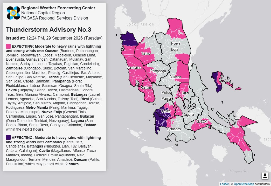
Thunderstorm Advisory No. 3 #NCR_PRSD
Issued at: 12:24 PM, 29 September 2026(Tuesday)
Moderate to heavy rainshowers with lightning and strong winds are expected over Batangas (Laurel, Lemery, Agoncillo, San Nicolas, Talisay, and Taal), Bulacan (Dona Remedios Trinidad and Norzagaray), Cavite (Tagaytay, Silang, Tanza, Dasmarinas, General Trias, Gen. Mariano Alvarez, and Carmona), Laguna (San Pedro, Binan, Santa Rosa, Cabuyao, and Calamba), Metro Manila (Pasig, Marikina, Taguig, Pateros, and Muntinlupa), Nueva Ecija (General Tinio, Carranglan, Lupao, San Jose, and Pantabangan), Pampanga (Porac, Floridablanca, Lubao, Sasmuan, Guagua, and Santa Rita), Quezon (Burdeos, Patnanungan, Jomalig, Tagkawayan, Lopez, Macalelon, General Luna, Buenavista, Guinayangan, Catanauan, Mulanay, San Narciso, Sariaya, Lucena, Tayabas, Pagbilao, and Candelaria), Rizal (Cainta, Taytay, Antipolo, San Mateo, Angono, Binangonan, Teresa, and Rodriguez), Tarlac (San Clemente, Mayantoc, San Jose, Capas, and Bamban), Zambales (Olongapo, Subic, Botolan, San Marcelino, Cabangan, Iba, Masinloc, Palauig, Castillejos, San Antonio, San Felipe, and San Narciso), and Bataan within the next 2 hours.
The above condition is affecting Batangas (Nasugbu, Lian, Tuy, Balayan, Calaca, and Calatagan), Cavite (Magallanes, Alfonso, Trece Martires, Indang, General Emilio Aguinaldo, Naic, Maragondon, Ternate, Mendez, and Amadeo), Quezon (Polillo and Panukulan), and Zambales (Santa Cruz and Candelaria) which may persist within 2 hours.
All are advised to take precautionary measures against the impacts associated with these hazards which include flash floods and landslides.
Keep monitoring for updates.
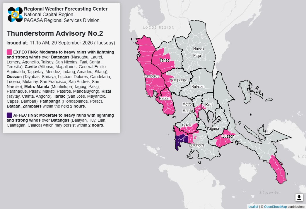
Thunderstorm Advisory No. 2 #NCR_PRSD
Issued at: 11:15 AM, 29 September 2026(Tuesday)
Moderate to heavy rainshowers with lightning and strong winds are expected over Batangas (Nasugbu, Laurel, Lemery, Agoncillo, Talisay, San Nicolas, Taal, and Santa Teresita), Cavite (Alfonso, Magallanes, General Emilio Aguinaldo, Tagaytay, Mendez, Indang, Amadeo, and Silang), Metro Manila (Muntinlupa, Taguig, Pasig, Paranaque, Pasay, Makati, Pateros, and Mandaluyong), Pampanga (Floridablanca and Porac), Quezon (Tayabas, Sariaya, Lucban, Dolores, Candelaria, Lucena, Mulanay, San Francisco, San Andres, and San Narciso), Rizal (Taytay, Cainta, and Angono), Tarlac (San Jose, Mayantoc, Capas, and Bamban), Bataan, and Zambales within the next 2 hours.
The above condition is affecting Batangas (Balayan, Tuy, Lian, Calatagan, and Calaca) which may persist within 2 hours.
All are advised to take precautionary measures against the impacts associated with these hazards which include flash floods and landslides.
Keep monitoring for updates.
5-DAY REGIONAL WEATHER OUTLOOK for #NCR_PRSD
Issued at: 9:00 AM, 29 September 2026
Valid Beginning: 9:00 AM today - 9:00 AM tomorrow
https://t.co/FgzeJ2NtSQ
***Help us improve our service by answering this quick survey.
Kindly follow this link: https://t.co/qnRqQ9kVj7
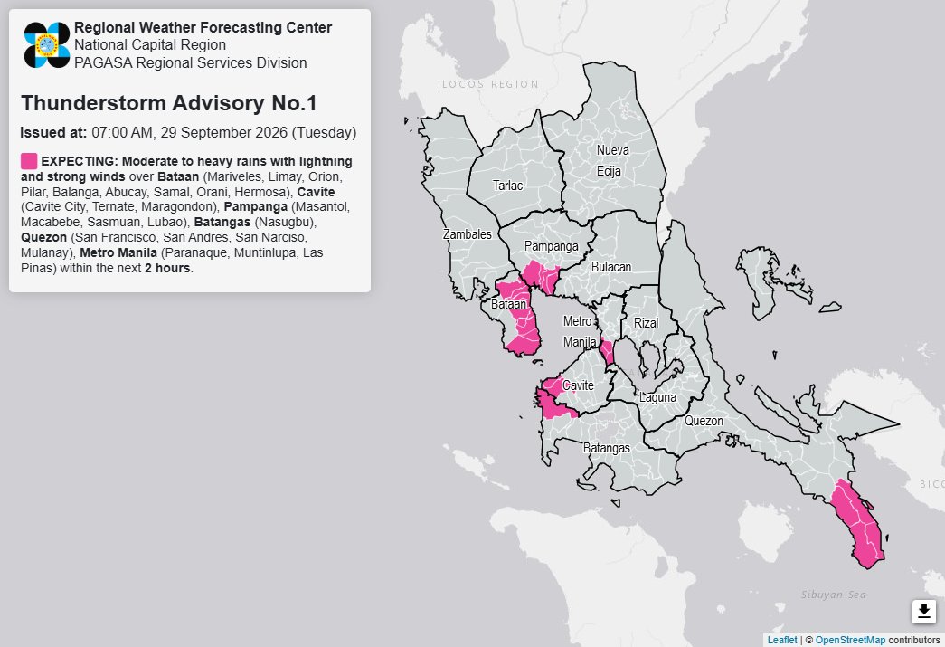
Thunderstorm Advisory No. 1 #NCR_PRSD
Issued at: 7:00 AM, 29 September 2026(Tuesday)
Moderate to heavy rainshowers with lightning and strong winds are expected over Bataan (Mariveles, Limay, Orion, Pilar, Balanga, Abucay, Samal, Orani, and Hermosa), Batangas (Nasugbu), Cavite (Cavite City, Ternate, and Maragondon), Metro Manila (Paranaque, Muntinlupa, and Las Pinas), Pampanga (Masantol, Macabebe, Sasmuan, and Lubao), and Quezon (San Francisco, San Andres, San Narciso, and Mulanay) within the next 2 hours.
All are advised to take precautionary measures against the impacts associated with these hazards which include flash floods and landslides.
Keep monitoring for updates.
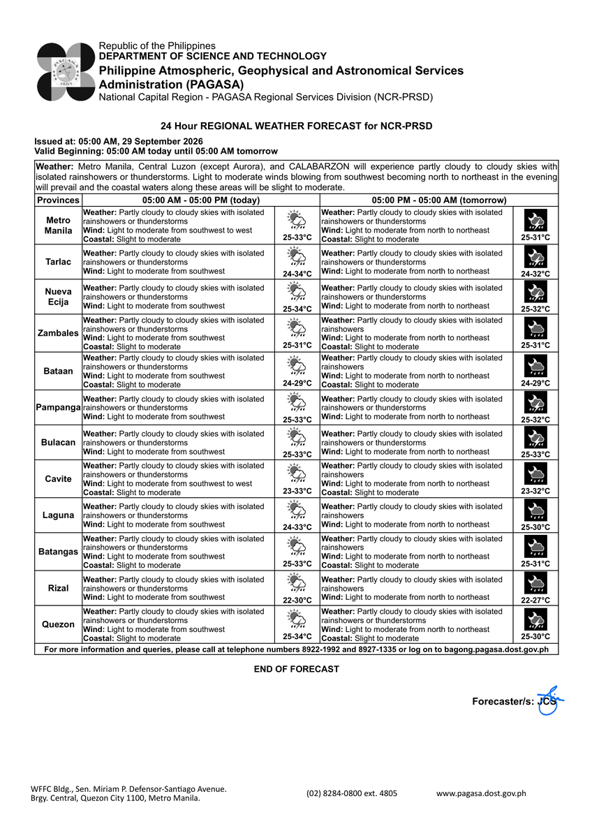
REGIONAL WEATHER FORECAST for #NCR_PRSD
Issued at: 5:00 AM, 29 September 2026
Valid Beginning: 5:00 AM today - 5:00 AM tomorrow
https://t.co/FgzeJ2NtSQ
***Help us improve our service by answering this quick survey.
Kindly follow this link: https://t.co/qnRqQ9kVj7