TROPICAL CYCLONE ADVISORY NR. 2
Tropical Storm HAISHEN
Issued at 11:00 PM, 13 July 2026
Valid for broadcast until the next bulletin at 11:00 AM tomorrow.
HAISHEN HAS INTENSIFIED INTO A TROPICAL STORM.
DOST-PAGASA
Link:https://t.co/Qn10X0QYBE
Rainfall Advisory No. 7-Final #NCR_PRSD
Weather System: Southwest Monsoon (Habagat)
Issued at: 11:00 PM, 13 July 2026(Monday)
All Rainfall Advisory over NCR-PRSD forecast area are now TERMINATED.
The public and the Disaster Risk Reduction and Management Offices concerned are still advised to MONITOR the weather condition.
For more information and queries, please call telephone numbers 8927-1335 and 8927-2877 or log on to https://t.co/59mTpZJq1n.
Rainfall Advisory No. 6 #NCR_PRSD
Weather System: Southwest Monsoon (Habagat)
Issued at: 8:00 PM, 13 July 2026(Monday)
Light to moderate with occasional heavy rains are expected over Bataan, Pampanga and Bulacan(Hagonoy, Paombong, Malolos, Plaridel, Pulilan, Calumpit, Bustos, Baliuag, San Rafael, San Ildefonso, San Miguel, Angat, Dona Remedios Trinidad).
Light to moderate with occasional heavy rains affecting Zambales(Candelaria, Santa Cruz, Masinloc), Nueva Ecija(Lupao, Carranglan, San Jose, Pantabangan, Zaragoza, Licab, Aliaga, San Antonio, Jaen) and Tarlac(La Paz, Tarlac City, Concepcion, Camiling, San Clemente, Mayantoc, San Jose) and may affect nearby areas.
The public and the Disaster Risk Reduction and Management Offices concerned are advised to MONITOR the weather condition and watch for the next warning to be issued at 11:00 PM today.
For more information and queries, please call telephone numbers 8927-1335 and 8927-2877 or log on to https://t.co/59mTpZJq1n.
Thunderstorm Advisory No. 4 #NCR_PRSD
Issued at: 5:30 PM, 13 July 2026(Monday)
Moderate to heavy rainshowers with lightning and strong winds are expected over Batangas(Batangas City, Taysan, Lobo) within the next 2 hours.
The above conditions are being experienced in Quezon(Calauag, Quezon, Lopez, Guinayangan) which may persist within 2 hours and may affect nearby areas.
All are advised to take precautionary measures against the impacts associated with these hazards which include flash floods and landslides.
Keep monitoring for updates.
Rainfall Advisory No. 5 #NCR_PRSD
Weather System: Southwest Monsoon (Habagat)
Issued at: 5:00 PM, 13 July 2026(Monday)
Light to moderate with occasional heavy rains are expected over Nueva Ecija, Rizal, Cavite, Quezon(General Nakar), Laguna(San Pedro, Binan, Santa Rosa, Cabuyao, Calamba, Los Banos, Bay, Alaminos, Calauan, Victoria) and Batangas(Agoncillo, Alitagtag, Balayan, Balete, Bauan, Calaca, Calatagan, Tanauan, Cuenca, Laurel, Lemery, Lian, Mabini, Malvar, Mataasnakahoy, Nasugbu, San Luis, San Nicolas, Santa Teresita, Santo Tomas, Taal, Talisay, Tingloy, Tuy, Lipa, San Jose, San Pascual).
Light to moderate with occasional heavy rains affecting Zambales, Bataan, Tarlac(San Jose, Capas, Bamban), Pampanga(Mabalacat, Angeles, Porac, Floridablanca, Lubao, Candaba), Bulacan(San Miguel, San Ildefonso, San Rafael, Dona Remedios Trinidad, Angat, Santa Maria, San Jose del Monte, Norzagaray, Marilao, Meycauayan, Obando, Bulakan, Bocaue, Pandi, Balagtas, Guiguinto, Bustos, Paombong, Malolos, Hagonoy) and Metro Manila(Navotas, Valenzuela, Malabon, Caloocan) and may affect nearby areas.
The public and the Disaster Risk Reduction and Management Offices concerned are advised to MONITOR the weather condition and watch for the next warning to be issued at 8:00 PM today.
For more information and queries, please call telephone numbers 8927-1335 and 8927-2877 or log on to https://t.co/59mTpZJq1n.
REGIONAL WEATHER FORECAST for #NCR_PRSD
Issued at: 5:00 PM, 13 July 2026
Valid Beginning: 5:00 PM today - 5:00 PM tomorrow
https://t.co/FgzeJ2NtSQ
Help us improve our service by answering this quick survey.
Kindly follow this link: https://t.co/GG5gDsTW29.
Thunderstorm Advisory No. 3 #NCR_PRSD
Issued at: 3:22 PM, 13 July 2026(Monday)
Moderate to heavy rainshowers with lightning and strong winds are expected over Bulacan(Norzagaray, San Jose del Monte, Santa Maria, Marilao, Meycauayan, Dona Remedios Trinidad), Laguna(Rizal, San Pablo, Nagcarlan, Majayjay, Liliw, Luisiana, Magdalena, Cavinti) and Quezon(Sampaloc, Lucban, Tayabas, Candelaria, Dolores, Sariaya) within the next 2 hours.
The above conditions are being experienced in Rizal(Rodriguez) and Metro Manila(Quezon City) which may persist within 2 hours and may affect nearby areas.
All are advised to take precautionary measures against the impacts associated with these hazards which include flash floods and landslides.
Keep monitoring for updates.
Rainfall Advisory No. 4 #NCR_PRSD
Weather System: Southwest Monsoon (Habagat)
Issued at: 2:00 PM, 13 July 2026(Monday)
Light to moderate rains are expected over Bulacan(Calumpit, Hagonoy, Paombong, San Miguel, San Ildefonso, San Rafael, Baliuag, Pulilan, Plaridel, Malolos, Bulakan, Bustos, Guiguinto) and Nueva Ecija(Cabiao, San Antonio, San Isidro).
Light to moderate rains affecting Zambales(Masinloc, Palauig, Iba, Botolan, Olongapo, San Antonio, Castillejos, San Marcelino, Subic, San Felipe, Cabangan, San Narciso), Tarlac(San Jose, Capas, Bamban), Pampanga(Mabalacat, Angeles, Porac, Floridablanca, Santa Rita, Guagua, Lubao) and Bataan(Morong, Dinalupihan, Hermosa) and may affect nearby areas.
The public and the Disaster Risk Reduction and Management Offices concerned are advised to MONITOR the weather condition and watch for the next warning to be issued at 5:00 PM today.
For more information and queries, please call telephone numbers 8927-1335 and 8927-2877 or log on to https://t.co/59mTpZJq1n.
Thunderstorm Advisory No. 2 #NCR_PRSD
Issued at: 1:31 PM, 13 July 2026(Monday)
Moderate to heavy rainshowers with lightning and strong winds are expected over Laguna(Santa Rosa, Cabuyao, Binan, San Pedro, Calamba, Mabitac, Pakil, Pangil, Siniloan, Famy, Santa Maria), Metro Manila(Muntinlupa, Paranaque, Las Pinas, Taguig, Pasig, Makati, Pateros, Pasay), Rizal(Cainta, Taytay, Angono, Binangonan, Cardona, Morong, Teresa, Antipolo, Pililla, Jala-Jala, Baras, Tanay) and Quezon(Mauban, Pagbilao, Tayabas, Sampaloc, Lucban, Lucena, Atimonan) within the next 2 hours.
The above conditions are being experienced in Nueva Ecija(Lupao, Munoz) and Cavite(Silang) which may persist within 2 hours and may affect nearby areas.
All are advised to take precautionary measures against the impacts associated with these hazards which include flash floods and landslides.
Keep monitoring for updates.
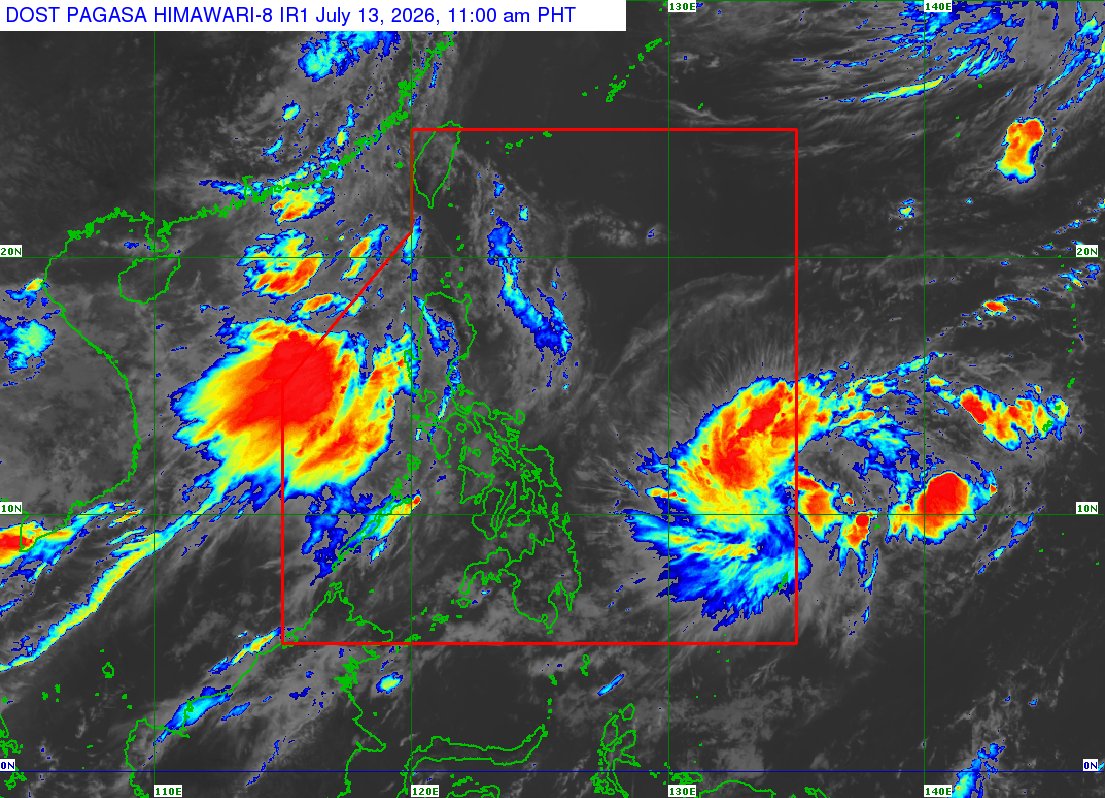
TROPICAL CYCLONE ADVISORY NR. 1
Tropical Depression HAISHEN
Issued at 11:00 AM, 13 July 2026
Valid for broadcast until the next bulletin at 11:00 PM today.
THE LOW PRESSURE AREA EAST OF VISAYAS DEVELOPED INTO A TROPICAL DEPRESSION.
Link:https://t.co/Qn10X0QYBE
Rainfall Advisory No. 3 #NCR_PRSD
Weather System: Southwest Monsoon (Habagat)
Issued at: 11:00 AM, 13 July 2026(Monday)
Light to moderate rains are expected over Bataan and Tarlac(Capas, San Jose, Mayantoc, San Clemente).
Light to moderate rains affecting Zambales(Cabangan, Botolan, Iba) and may affect nearby areas.
The public and the Disaster Risk Reduction and Management Offices concerned are advised to MONITOR the weather condition and watch for the next warning to be issued at 2:00 PM today.
For more information and queries, please call telephone numbers 8927-1335 and 8927-2877 or log on to https://t.co/59mTpZJq1n.
Thunderstorm Advisory No. 1 #NCR_PRSD
Issued at: 10:55 AM, 13 July 2026(Monday)
Moderate to heavy rainshowers with lightning and strong winds are expected over Cavite(Noveleta, Cavite City, Kawit, Imus, Bacoor, Dasmarinas, General Trias, Rosario, Gen. Mariano Alvarez, Carmona, Tanza, Trece Martires, Amadeo, Silang, Tagaytay), Metro Manila(Las Pinas, Paranaque, Taguig, Muntinlupa, Pasay, Makati, Mandaluyong, San Juan, Pasig, Manila, Quezon City, Marikina, Pateros, Caloocan), Rizal(San Mateo, Antipolo, Cainta, Taytay, Angono, Binangonan, Teresa, Morong, Cardona, Baras, Rodriguez), Laguna(San Pedro, Binan, Santa Rosa, Cabuyao, Calamba), Batangas(Talisay, Tanauan, Laurel) and Bulacan(San Jose del Monte, Norzagaray) within the next 2 hours.
All are advised to take precautionary measures against the impacts associated with these hazards which include flash floods and landslides.
Keep monitoring for updates.
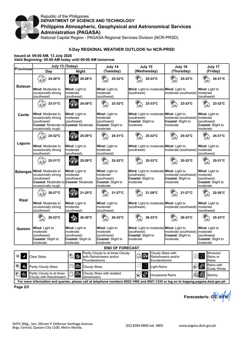
5-DAY REGIONAL WEATHER OUTLOOK for #NCR_PRSD
Issued at: 9:00 AM, 13 July 2026
Valid Beginning: 9:00 AM today - 9:00 AM tomorrow
https://t.co/FgzeJ2NtSQ
***Help us improve our service by answering this quick survey.
Kindly follow this link: https://t.co/GG5gDsTW29
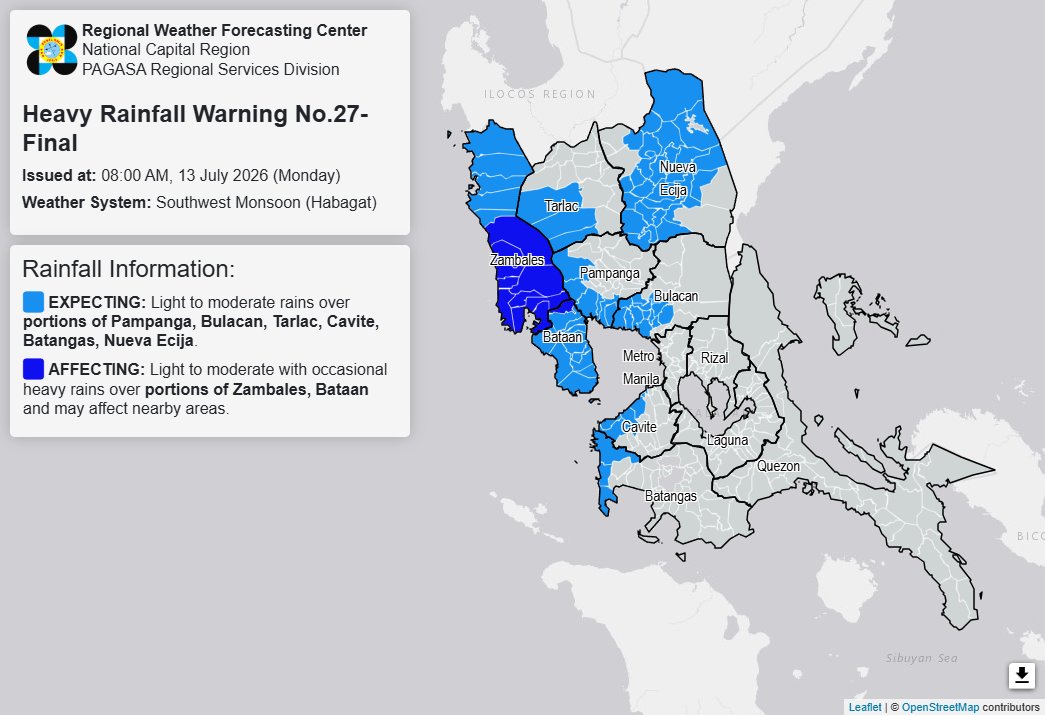
Heavy Rainfall Warning No. 27-Final #NCR_PRSD
Weather System: Southwest Monsoon (Habagat)
Issued at: 8:00 AM, 13 July 2026(Monday)
Light to moderate rains was observed over Zambales and Bataan for the past 3 hours. With this development all RAINFALL WARNING in these areas are now terminated.
Meanwhile, expect light to moderate rains over Pampanga(Lubao, Sasmuan, Macabebe, Masantol, Floridablanca, Porac), Bulacan(Hagonoy, Paombong, Calumpit, Malolos, Santa Maria, Bocaue, Bulakan, Balagtas, Guiguinto, Pandi, Plaridel, Pulilan, Bustos), Tarlac(Bamban, Capas, San Jose), Cavite(Noveleta, Cavite City, Rosario, Tanza, Naic, Ternate, Maragondon), Batangas(Nasugbu, Lian, Calatagan) and Nueva Ecija(Lupao, San Jose, Talugtug, Pantabangan, Munoz, Santo Domingo, Talavera, Llanera, Rizal, General Mamerto Natividad, Carranglan, San Leonardo, Santa Rosa, Cabanatuan, Aliaga, Quezon, Palayan, Bongabon, Laur, Penaranda, Jaen, San Isidro, Gapan, Cabiao, San Antonio, Zaragoza, Licab) within the next 3 hours.
Light to moderate with occasional heavy rains affecting Zambales(Olongapo, San Antonio, Castillejos, San Marcelino, San Narciso, Botolan, Cabangan, San Felipe, Subic) and Bataan(Dinalupihan) which may persist within 3 hours.
The public and the Disaster Risk Reduction and Management Offices concerned are still advised to MONITOR the weather condition.
For more information and queries, please call telephone numbers 8927-1335 and 8927-2877 or log on to https://t.co/59mTpZJq1n.
Heavy Rainfall Warning No. 26 #NCR_PRSD
Weather System: Southwest Monsoon (Habagat)
Issued at: 5:00 AM, 13 July 2026(Monday)
YELLOW WARNING LEVEL: Zambales(San Antonio, Subic, Olongapo, Castillejos, San Narciso, Santa Cruz, Candelaria, Masinloc, Palauig) and Bataan(Morong).
ASSOCIATED HAZARD: FLOODING in flood-prone areas.
Meanwhile, expect light to moderate rains over Pampanga(Floridablanca, Lubao, Porac, Masantol, Sasmuan, Macabebe, Santa Rita, Guagua, Angeles, Mabalacat, Minalin, Bacolor, San Fernando, Santo Tomas), Tarlac(Bamban, Capas, San Jose, Mayantoc, San Clemente, Camiling, Santa Ignacia), Batangas(Nasugbu, Lian, Calatagan) and Cavite(Ternate, Naic, Tanza) within the next 3 hours.
Light to moderate rains affecting Bataan(Bagac, Mariveles) and Zambales(San Felipe, Cabangan, Iba, Botolan, San Marcelino) which may persist within 3 hours and may affect nearby areas.
The public and the Disaster Risk Reduction and Management Offices concerned are advised to MONITOR the weather condition and watch for the next warning to be issued at 8:00 AM today.
For more information and queries, please call telephone numbers 8927-1335 and 8927-2877 or log on to https://t.co/59mTpZJq1n.
REGIONAL WEATHER FORECAST for #NCR_PRSD
Issued at: 5:00 AM, 13 July 2026
Valid Beginning: 5:00 AM today - 5:00 AM tomorrow
https://t.co/FgzeJ2NtSQ
***Help us improve our service by answering this quick survey.
Kindly follow this link: https://t.co/GG5gDsTW29
REGIONAL WEATHER FORECAST for GREATER METRO MANILA AREA (GMMA) #NCR_PRSD
Issued at: 4:00 AM, 13 July 2026
Valid Beginning: 4:00 AM - 10:00 AM today
https://t.co/FgzeJ2NtSQ
Heavy Rainfall Warning No. 25 #NCR_PRSD
Weather System: Southwest Monsoon (Habagat)
Issued at: 2:00 AM, 13 July 2026(Monday)
YELLOW WARNING LEVEL: Bataan and Zambales(Olongapo, Subic, San Marcelino, Castillejos, San Antonio, San Felipe, San Narciso).
ASSOCIATED HAZARD: FLOODING in flood-prone areas.
Meanwhile, expect light to moderate with occasional heavy rains over Metro Manila, Cavite, Bulacan(Angat, Balagtas, Baliuag, Bocaue, Bustos, Meycauayan, San Jose del Monte, Marilao, Obando, Pandi, San Ildefonso, San Miguel, San Rafael, Santa Maria, Plaridel, Pulilan, Malolos, Bulakan, Guiguinto, Calumpit, Hagonoy, Paombong), Nueva Ecija(Cabiao, Gapan, San Antonio, San Isidro, Aliaga, Cuyapo, Guimba, Jaen, Licab, Nampicuan, Quezon, San Leonardo, Talugtug, Zaragoza), Batangas(Nasugbu, Lian, Balayan, Calatagan, Tuy, Calaca, Laurel, Lemery, Agoncillo, Talisay, San Nicolas), Rizal(San Mateo, Taytay, Cainta, Angono, Binangonan, Teresa, Morong, Antipolo) and Laguna(San Pedro, Santa Rosa, Binan) within the next 3 hours.
Light to moderate with occasional heavy rains affecting Zambales(Botolan, Cabangan, Candelaria, Iba, Masinloc, Palauig, Santa Cruz), Tarlac(San Jose, Capas, Bamban, Mayantoc, San Clemente, Camiling, Santa Ignacia) and Pampanga(Porac, Floridablanca, Lubao, Sasmuan, Macabebe, Bacolor, San Fernando, Masantol, Minalin, Santo Tomas, Angeles, Mabalacat, Guagua, Santa Rita) which may persist within 3 hours and may affect nearby areas.
The public and the Disaster Risk Reduction and Management Offices concerned are advised to MONITOR the weather condition and watch for the next warning to be issued at 5:00 AM today.
For more information and queries, please call telephone numbers 8927-1335 and 8927-2877 or log on to https://t.co/59mTpZJq1n.
Heavy Rainfall Warning No. 24 #NCR_PRSD
Weather System: Southwest Monsoon (Habagat)
Issued at: 11:00 PM, 12 July 2026(Sunday)
YELLOW WARNING LEVEL: Bataan and Zambales(Cabangan, San Narciso, San Antonio, Subic, San Marcelino, Olongapo, Castillejos, San Felipe).
ASSOCIATED HAZARD: FLOODING in flood-prone areas.
Meanwhile, light to moderate with occasional heavy rains affecting Metro Manila, Bulacan, Pampanga, Cavite, Batangas, Laguna, Rizal, Zambales(Candelaria, Iba, Masinloc, Palauig, Santa Cruz, Botolan), Tarlac(Concepcion, Bamban, Capas, Tarlac City, La Paz, San Jose), Nueva Ecija(San Antonio, Gapan, San Isidro, Cabiao, Jaen, San Leonardo, Zaragoza, Santa Rosa, Penaranda, General Tinio) and Quezon(General Nakar, Infanta, Real, Sariaya, Tiaong, San Antonio, Dolores, Candelaria, Tayabas, Lucban, Lucena, Pagbilao, Sampaloc) which may persist within 3 hours and may affect nearby areas.
The public and the Disaster Risk Reduction and Management Offices concerned are advised to MONITOR the weather condition and watch for the next warning to be issued at 2:00 AM tomorrow.
For more information and queries, please call telephone numbers 8927-1335 and 8927-2877 or log on to https://t.co/59mTpZJq1n.
Thunderstorm Advisory No. 9 #NCR_PRSD
Issued at: 10:25 PM, 12 July 2026(Sunday)
Moderate to heavy rainshowers with lightning and strong winds are expected over Laguna(Majayjay, Luisiana, Cavinti, Lumban, Paete, Kalayaan) within the next 2 hours.
The above conditions are being experienced in Quezon(Mauban, Tayabas, Pagbilao, Atimonan, Perez, Padre Burgos, Agdangan, Sampaloc, Lucban) which may persist within 2 hours and may affect nearby areas.
All are advised to take precautionary measures against the impacts associated with these hazards which include flash floods and landslides.
Keep monitoring for updates.