After months of hard work, we're excited to announce our new weather tracking and analysis site, coming this March!
We’ll be dropping weekly teasers leading up to the launch, so keep an eye out for sneak peeks.
No exact release date yet, but you’ll be the first to know. Stay tuned!
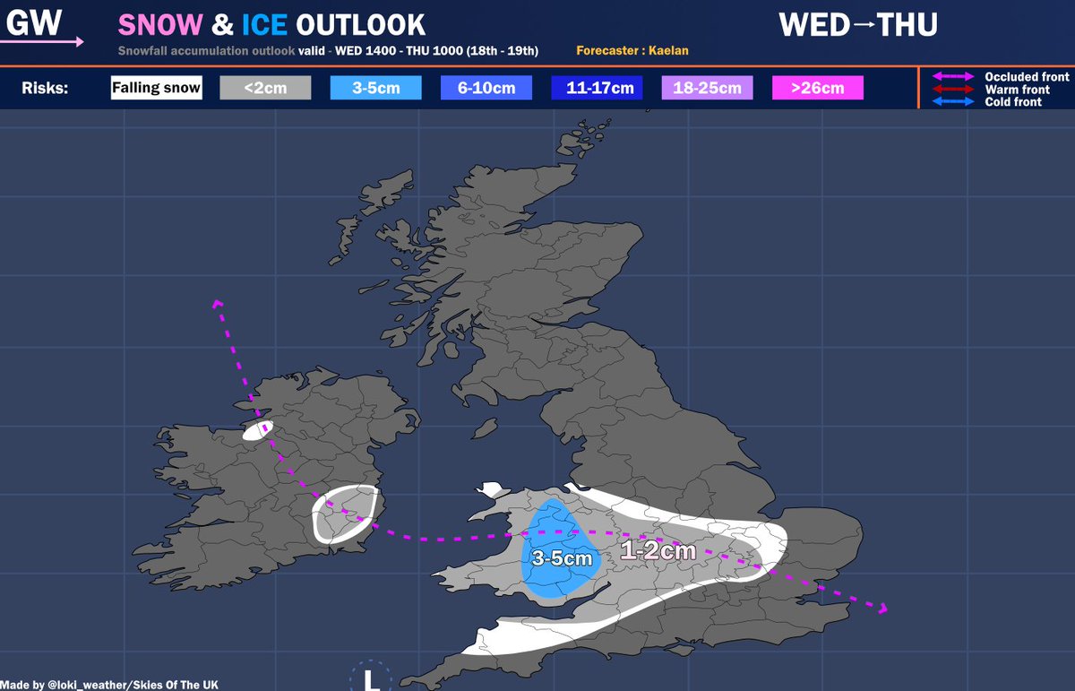
On Wednesday, an occluded front will approach the south moving North East across the country.
Many places *could recieve falling snow however, accumulations will be unlikely towards lower levels. nonetheless, there is a risk of wide spread snow falling Wednesday night.
Storm Marta looks really concerning, and yet again, I dont think the Portuguese are aware of how impactful this situation COULD be. We saw the damage from Storm Kristin and its still there + the flooding currently ongoing.
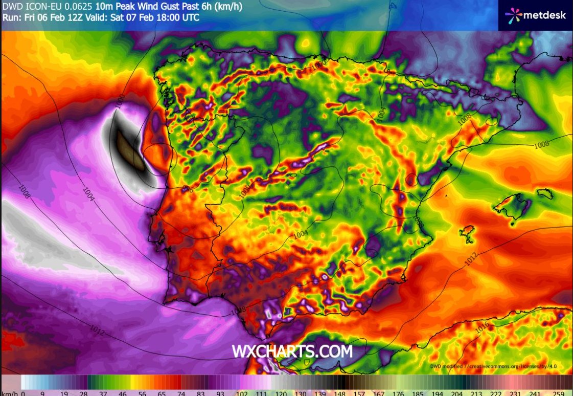
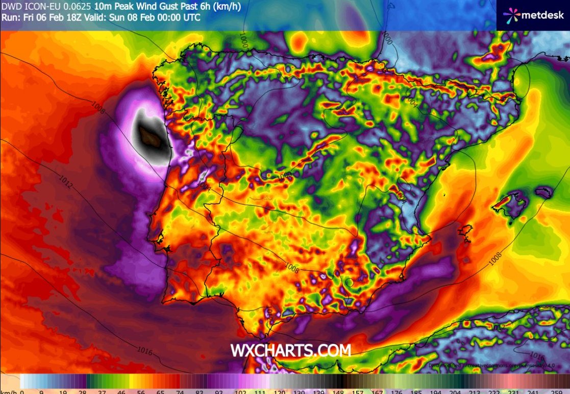
There is growing confidence in high res models (mainly the ICONS) that another sting jet will impact Portugal in a very similar place as it did last time. Gusts could reach 85mph+ along coasts which would likely result in more damage than Storm Kirstin due to the weakened infrastructure. Please stay up to date on this situation if u live in Portugal.
Let me just start off this update with good news… the relentless rainfall in Portugal and Spain may slow down towards the middle of February, as the Azores High potentially strengthens and builds over Iberia. Even still, as I explained in my forecast today, we have a long way to go before the weather pattern shifts dramatically and brings a more solid period of dry weather.
Anyways, any improvement is welcome. Until then, we have Storm #Leonardo and then multiple low pressure systems slowly guiding this next plume of moisture across the Atlantic from February 7-11.
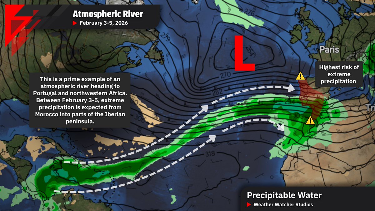
Between February 3-5, an “atmospheric river” will affect the Iberian Peninsula and parts of North Africa. Here are some important details 👇
The term “atmospheric river” is self-explanatory. These are narrow but long bands (rivers) of concentrated water vapor in the atmosphere. They’re very common, and Europe (including Iberia) is affected by these conveyer belts of moisture every year.
The amount of moisture that these rivers carry, their duration, and length can all vary… and those are just some of the factors that dictate their possible impact.
Unfortunately, as I’ve mentioned in recent posts, Iberia and northwestern Africa are extremely saturated due to relentless Atlantic storms. Those affected by violent Storm #Kristin may face setbacks in cleanup efforts due to further waves of dangerous weather. Just within February 3-5, this atmospheric river will lead to widespread heavy/persistent rainfall for nearly all of Portugal, western/southern Spain, and northern Morocco. This is not to mention the next atmospheric river arriving between February 7-8.
The situation:
Waterlogged soil/swollen rivers + prolonged atmospheric river extending from the Caribbean Sea to Portugal leading to an additional 100-200+ mm of rainfall widely leads to a worsening flood threat, not to mention further rainfall after. There will be periods of strong winds as well.
Over 200 mm is possible in southern Spain and northern Morocco where precipitation rates could be highest, in fact Red Warnings have been issued in parts of southern Spain for Wednesday in anticipation of extreme rainfall.
Be sure to follow, like, and share if you find this information useful. Thank you for reading and please stay safe!
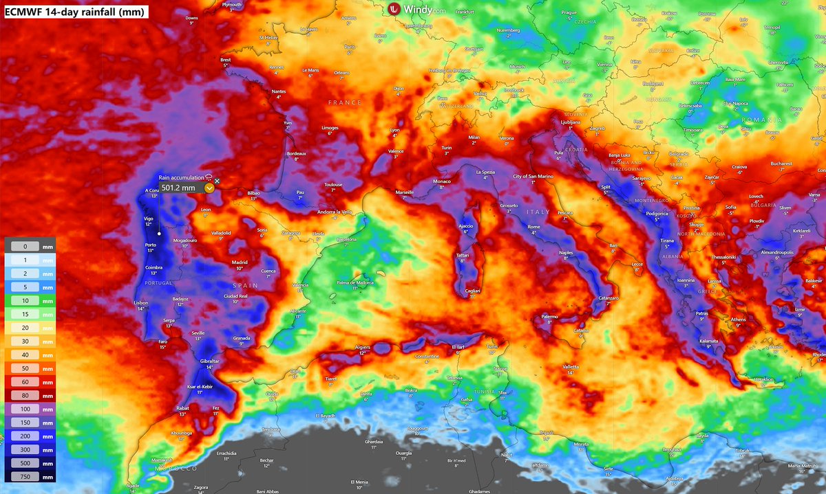
Extreme rainfall is expected across western Iberia, especially in Portugal, over the next 14 days. More rain is also expected for Spain, Italy, and the western Balkans. We will have more forecast details tomorrow. Stay tuned. @Windycom
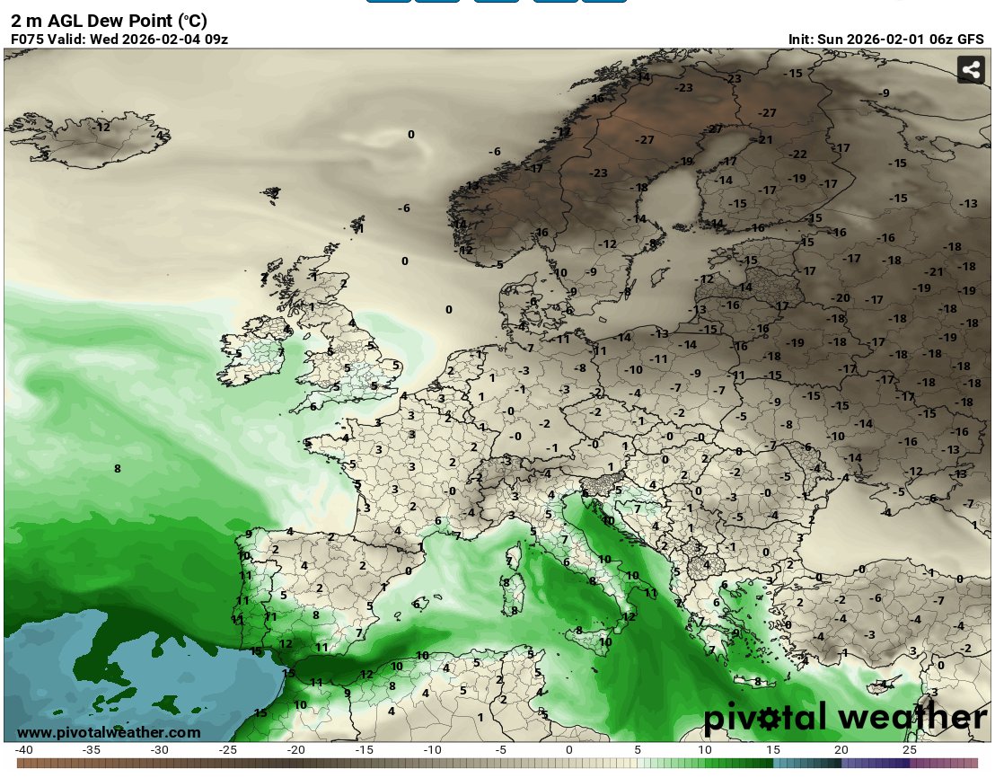
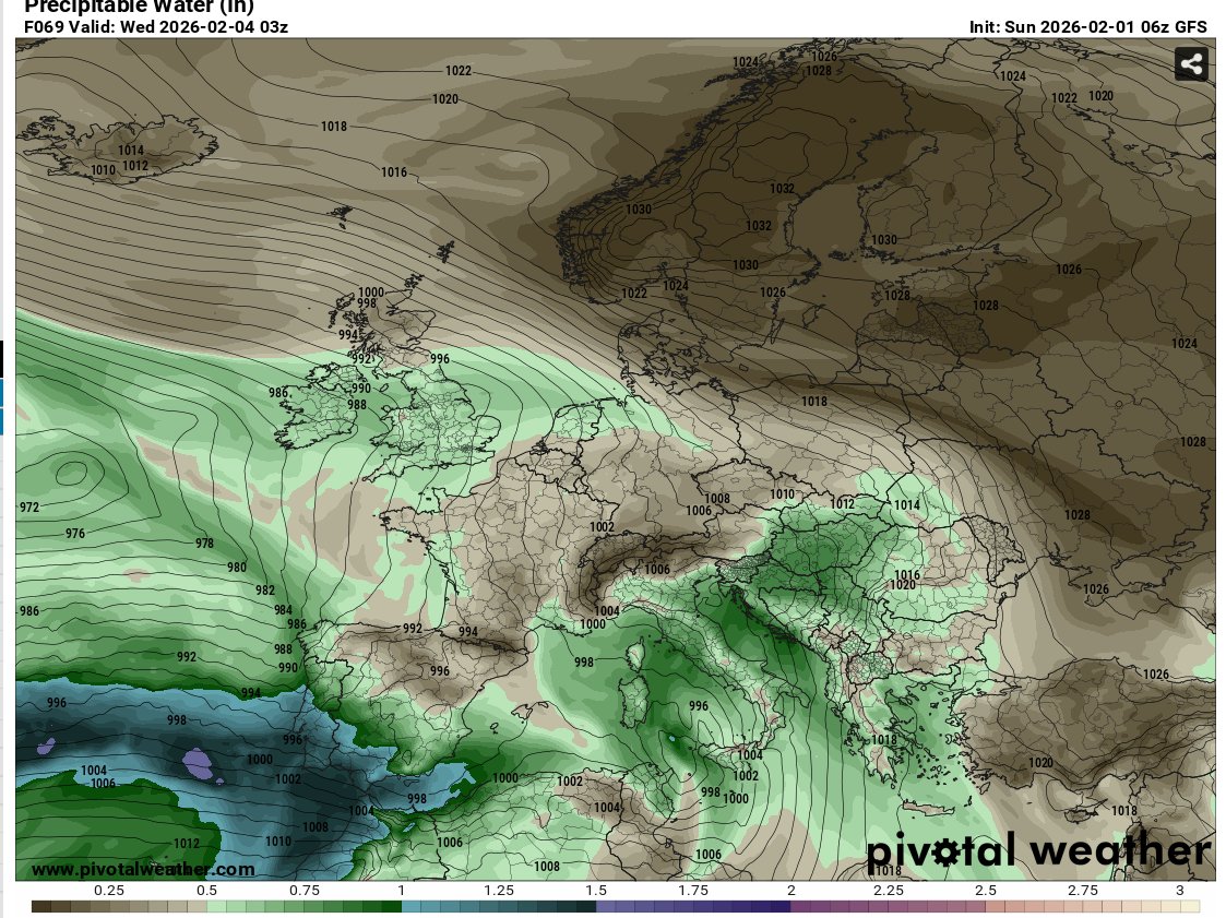
It's going to feel very humid and tropical across the far south of Spain and Portugal on Wednesday. This will be followed with heavy intense precipitable water (PW) which will likely produce long lasting spells of rain. All eyes on Portugal and Spain!
If you would like to keep up with latest severe weather updates across Europe, join our discord : https://t.co/0Oj9NWM8ez
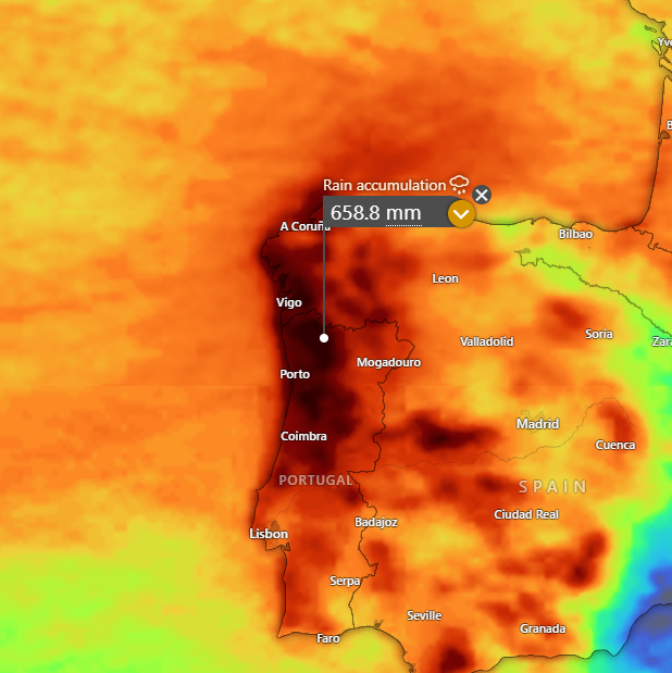
I dont think a lot of people are aware of how rare and dangerous the situation is in Portugal right now.
Over 600mm+ of rainfall is likely to fall between now and the 15th. This will lead to extreme flash flooding and potentially communties being cut off.
Along side this, strong winds may also be associated from the storms that are going to impact Portugal in the coming weeks.
Keep up to date with @WXWatcher07 on this particually dangerous situation.
Wow, I've hit 2,000 followers! It wasn't that long ago when I hit 1,000! Thank you so much for the support in recent months and I will continue to update you on severe weather across Europe!
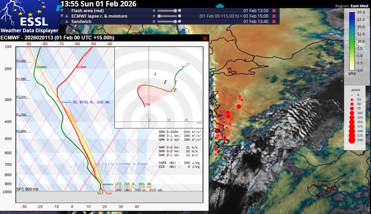
Quite intense storms are ongoing across SW Turkey in an environment of modest CAPE, but strong vertical wind shear, including a strongly curved hodograph and up to 200 m2/s2 SRH near the ground.
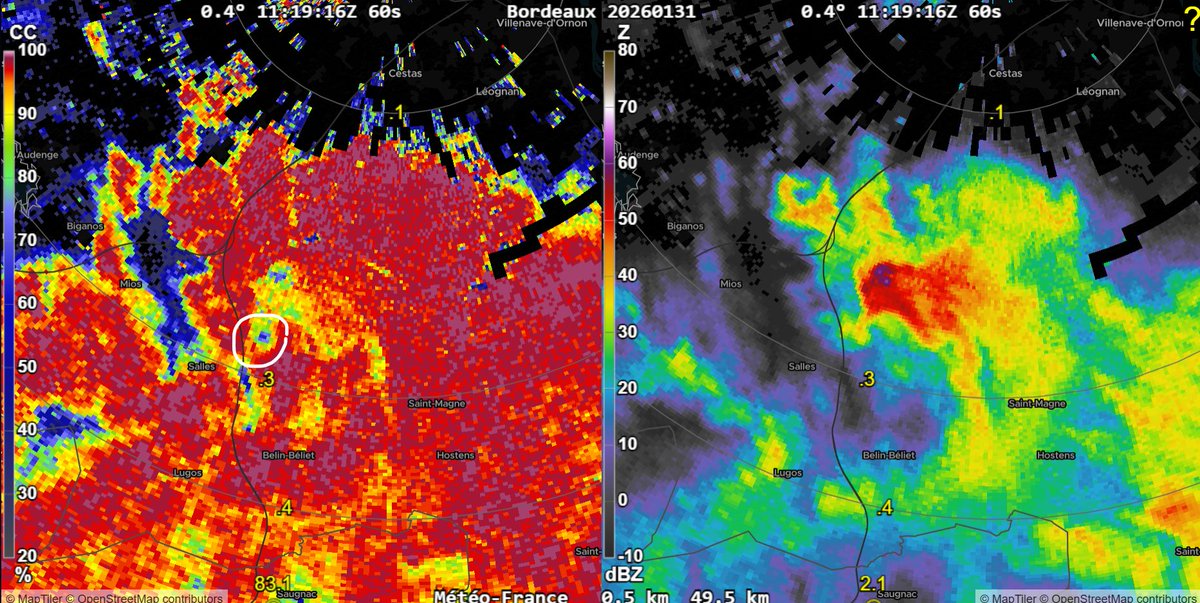
🚨We will post a short video covering the Mios tornado and it's impacts in France, either later today or tomorrow.
Once more data is released in regards to ratings, wind speed estimates, we will post a longer follow up video.