Celebrate President's Day with @IWCEexpo! 25% OFF ALL passes using promo PREZ25, plus FREE expo passes. Join us in Las Vegas, March 17 - 20
🕒 Offer valid: February 13 – 20
🌐 Register NOW: https://t.co/CglkbM49rg
PS: Not valid for existing registrations & government pricing.
Welcome to the VETRO team Ryan Trudeau! 🚀
Ryan, the new Senior Director of Sales Enablement, is passionate about driving success through collaboration and looks forward to partnering with the sales organization to help VETRO grow and succeed.
Welcome to the #VETROFamily!
Map of SW California and the current Red Flag Warnings in effect. All areas in red have a high risk for rapid fire growth if a fire starts. Areas outlined in purple are of most concern and are in a Particularly Dangerous Situation (PDS). Stay safe neighbors. #cawx
🚩 Critical Fire Weather Alert 🚩
Southern California is facing critical fire weather through Wednesday.
Life-threatening winds and dangerously low humidity are forecast for much of Southern California - from Ventura to San Diego - creating a significant risk of rapid fire spread.
The winds will cause increased fire activity. Here’s how you can help reduce the risk of new fire:
🚫 Avoid mowing or trimming dry grass on windy days.
🚗 Don’t Park vehicles on dry grass.
🔥 Make sure campfires are completely out.
👀 Report suspicious activity to help prevent arson.
State resources -- augmented by out-of-state and country help -- stand ready to respond.
Stay prepared. Stay safe. For fire prevention tips and emergency planning, visit https://t.co/xAsi7kicHn.
#CriticalFireWeather #WildfirePrevention #ReadyForWildfire
Heads up! Strong, locally damaging, NE/E winds will affect West LA Co. & much of Ventura Co thru Wednesday. Critical fire weather is expected, so PLEASE have multiple ways of getting notifications in case of new fires & prepare ahead of time. #venturacounty#LA#Cawx#Socal
HEADS UP!!! A LIFE-THREATENING, DESTRUCTIVE, Widespread Windstorm is expected Tue afternoon-Weds morning across much of Ventura/LA Co. Areas not typically windy will be impacted. See graphic for areas of greatest concern. Stay indoors, away from windows, expect poweroutages. #LA
Currently, we have ~8,300 customers without power located primarily in Hancock and Penobscot counties.
Customers without power at 10 p.m. should expect to be without power overnight. Crews will continue restoration efforts through the night.
https://t.co/GzdUKq8XWT
A full complement of internal crews and contractors continue to work on restoring power to about 5,300 customers from last night's snowstorm. They are following our outage approach to bring the most customers online with each repair.
Live outage map: https://t.co/yr5MhZRrUD
Versant Power crews are en route to restore power to approximately 2,170 customers in the Lincoln/Brownville area.
Crews will remain in the field making repairs safely and as quickly as possible until all customers are restored.
FMI: https://t.co/yr5MhZRrUD
After higher than predicted winds swept through our service territory, outages peaked at 20,500 at 1:30pm and about 10,100 are now without power. A full complement of line and tree crews are working to bring the most customers online at a time.
FMI:https://t.co/yr5MhZRrUD
⚠️ Life-threatening storm surge is forecast in the #TampaBay area and #SWFL
📏 Here’s an illustration of what this looks like 👇
🔠 Heed all evacuation orders #flwx
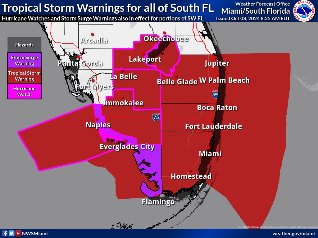
⚠️All of South Florida is now under a Tropical Storm Warning through Thursday at 8 AM⚠️
🌬️This means that tropical storm force wind gusts between 39-74 mph could be felt across the region.
🚨Hurricane watches and storm surge warnings remain in effect for SW FL.
#FLwx
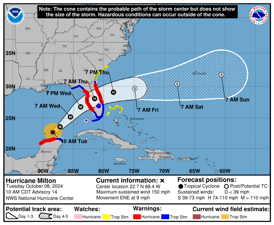
Update 1100 #MILTON FORECAST TO RETAIN MAJOR #HURRICANE STATUS AND EXPAND IN
SIZE WHILE IT APPROACHES THE WEST COAST OF #FLORIDA...
...TODAY IS THE LAST FULL DAY FOR FLORIDA RESIDENTS TO GET THEIR
FAMILIES AND HOMES READY AND EVACUATE IF TOLD TO DO SO BY LOCAL
OFFICIALS #FL
10/07/24 11am Major Hurricane Milton Update
⚠️Now a Category 5 Hurricane
⚠️If the storm stays on the current track, it will be the worst storm to impact the Tampa area in over 100 years.
⚠️Please evacuate if told to do so.
⚠️Complete all prep before tomorrow night. #flwx
Reminder: Travel in Western NC is limited to local and hurricane response traffic.
This map will help you detour around Western N.C., avoiding road closures and dangerous driving conditions 👉 https://t.co/gKHWg0UsYq
#HeleneNC#ncwx
Navigating the data migration labyrinth can be daunting for ISPs expanding their fiber networks. 🕸️ Dive into our latest blog post to read about challenges and best practices!
https://t.co/SnpyjqIjMX
#fibermanagement#datamigration#ISP#networkexpansion
⭐Case Study⭐
WTC envisioned a future where technology empowered them to deliver exceptional service. They sought a solution that would streamline operations, improve network visibility, and enhance customer experience.
Read WTC's full story here: https://t.co/YyghoJzuUA
🚨 All roads in Western NC should be considered closed 🚨
Do not travel unless an emergency or seeking higher ground
Do not drive through standing water
Respect barricades and road closures
#TurnAroundDontDrown#Helene#ncwx
‼️Situation Overview for #HurricaneHelene from our Hurricane Local Statement Product ‼️
(https://t.co/Hr6fIdtCfA).
PLEASE give this a read and do not take #Helene lightly.
#FLwx#ALwx#GAwx
Planning to travel and need to update your passport? The @StateDept announced that you can now renew online — streamlining the process and making it more convenient for Maine people across the state.
Learn more about how you can renew online 🌎⬇️
https://t.co/W78sYm8m8G