The City of NOLA’s emergency preparedness campaign, managed by New Orleans Homeland Security & Emergency Preparedness (NOHSEP). Not monitored 24/7. #NOLAReady
NOLAREADY: Traffic Alert: General De Gaulle Dr. (riverbound) is closed between Kabel Dr. & Shirley Dr. due to an oil spill. Expect delays & seek alternate route
NWS has issued a Heat Advisory for potentially dangerous heat conditions with “feels like” temps of 108°-110° today from 11 AM to 7 PM.
Stay hydrated, limit time outside, know the difference between heat exhaustion and heat stroke. Heat relief resources: https://t.co/AyuRn37IF4
NOCEM is hard at work supporting the work of RTA and NOPD’s Transit Police Unit as they begin a comprehensive effort to improve conditions at the Transit Hub located at the Main Library.
NOLAReady: Precautionary boil water advisory in effect for the entire Westbank. Boil water before consuming. Map of affected area here: https://t.co/gpFgXw7dh0
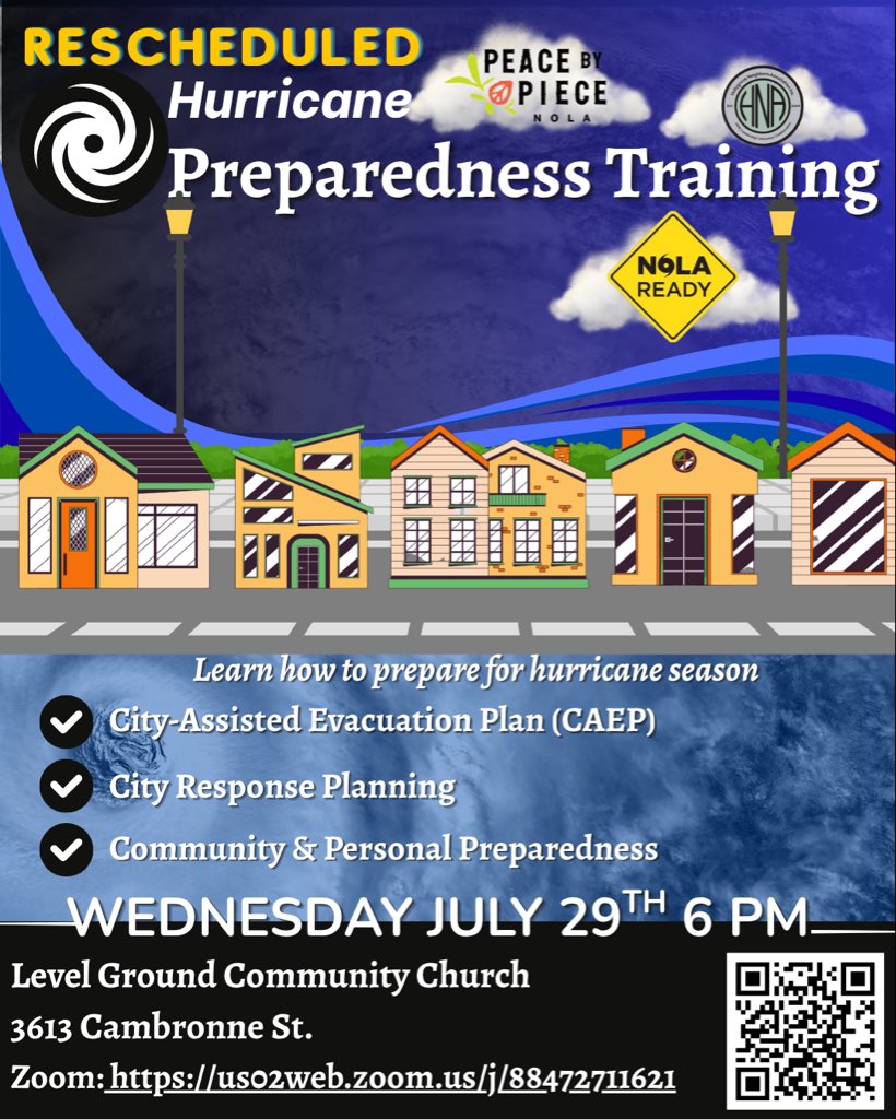
Join us for a Hurricane Preparedness Training 🌀
Wednesday, July 29th at 6 PM
Level Ground Community Church
3613 Cambronne St.
Zoom: https://t.co/6DMmXNYPns
Since the threat of Tropical Storm Bertha is moving out of our area, the Rosenwald Shelter will close tomorrow, Thursday, July 23 at 8 AM.
Huge thanks to our partners @2ndHarvestGNOA for providing food and @ARCLouisiana for blankets
Tropical Storm Bertha continues to move towards the Louisiana coast. While the threat of widespread heavy rainfall has decreased, dangerous heat, gusty winds and isolated power outages remain concerns today.
An Extreme Heat Warning has been issued for the area from 10 AM - 8 PM
NOLAREADY: Extreme Heat Warning 10 AM-8 PM. "Feels like" temps up to 118°. TS Bertha's rain threat has decreased. Limit outdoor activity & stay hydrated.
🌀 4AM Tropical Storm #Bertha Update. No major changes this forecast advisory. Bertha continues to move west and has started to weaken.
Max sustained winds 50 mph
Minimum central pressure 998mb.
We're seeing mutlple wind gusts of 30-40 mph in the open waters already.
👀No your eyes don't deceive you. We do have
🌀 Tropical Storm Watches/Warnings in place
and at the same time those same locations are also under
🥵Extreme Heat Warnings/Heat Advisories
As far as we can tell this is the first time this has ever happened. #Bertha#LAwx#MSwx
The City of New Orleans is closely monitoring Tropical Storm Bertha as it approaches southeast Louisiana late tonight/tomorrow. Clean catch basins, secure loose outdoor furniture and stay informed.
NOLAREADY: Complete preparations today. Secure loose outdoor items, clean catch basins & stay informed. Gusty winds & heavy rain possible late tonight.
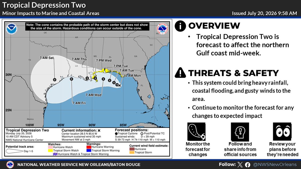
Heavy rainfall remains the primary concern with Tropical Depression Two, but wind gusts of 40 mph or greater are also possible later this week.
Gusty winds could begin as early as late Tuesday night, with the greatest potential for impacts Wednesday morning through evening.
Tropical Depression Two is forecast to affect the northern Gulf coast midweek.
This system could bring heavy rainfall for New Orleans of about 3-5 inches with locally higher amounts possible.
Wind gusts of 40 mph plus are possible. Stay weather aware & follow for updates.
10am CT: Here is a look at the latest conditions we expect for Tropical Depression Two! 🌀
It is currently in the northeast Gulf and expected to move west and affect the northern Gulf Coast mid-week.
We break down all the hazards here below. 👇
#mswx#lawx
🌀4AM update: @NHC_Atlantic shifted the track slightly north & now explicitly bring it onshore over SELA Wednesday. TD2 is still very poorly organized but it has stregthened to 35 mph with a pressure of 1007mb as it drifts northwest. It is forecast to turn to the west Tuesday.