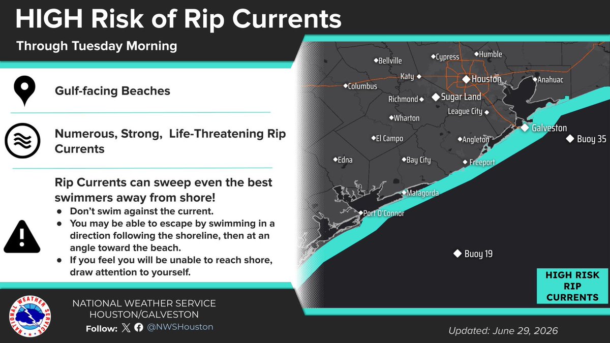
🌊There is a HIGH risk of rip currents through Tuesday morning.
☀️Heat continues through the week, with highs in the 90s and heat indices in the triple digits.
#TXwx#HOUwx
Our midyear reflection highlights current ground conditions moving into July, while also taking a look at longer term rainfall trends across TX and NM. #txwx#nmwx#drought#flood
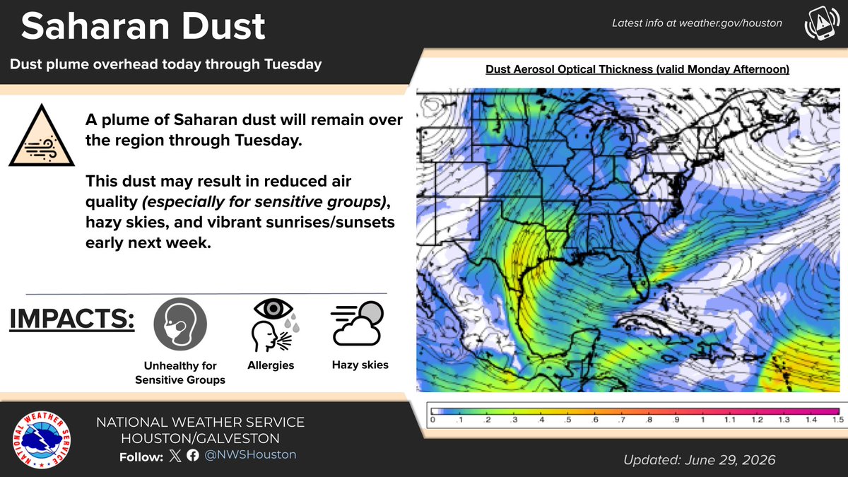
The Saharan Dust plume has arrived in SE TX🏜️
Little to no impacts are expected with the arrival of this plume. Hazy skies may reduce visibility, and air quality may be unhealthy for sensitive groups. If you get the chance, keep an eye out for vibrant sunrise/sunsets🌅
#TXwx
Warm, muggy night ahead. Heat continues into the week—stay cool & hydrated! Rain chances return mid-week. Saharan dust plume brings hazy skies thru Tuesday. Sensitive groups, watch air quality. Follow @NWSHouston for updates. #NWSHouston#HeatSafety#SaharanDust
Stay safe on the coast today!
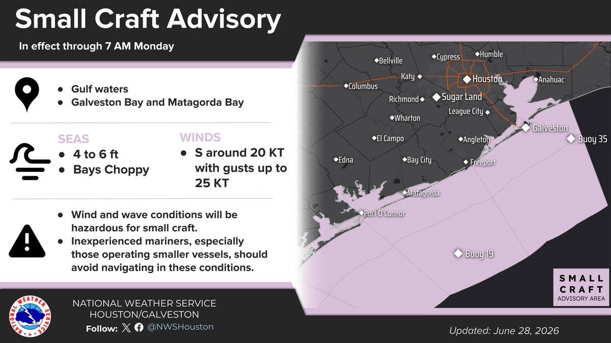
‼️A Small Craft Advisory is in effect now through Monday morning. Wind conditions will be hazardous for small craft.
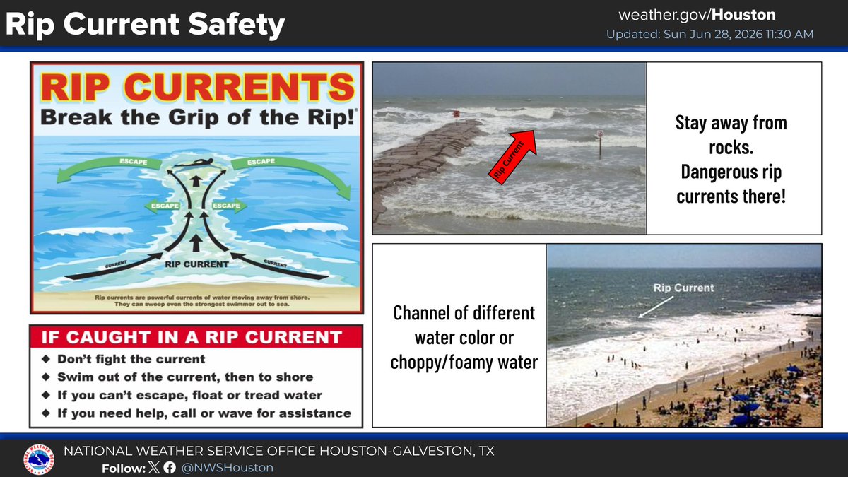
‼️There is a HIGH risk of rip currents through Monday evening. If you get caught in a rip current, follow the safety tips listed.
Heads up, SE TX! ☀️ Weekend weather:
🌊 Rip Current risk is HIGH—stay safe!
🔥 Heat sticks around Sunday (up to 96°F/36°C). Stay cool & hydrated!
💨 Saharan dust arrives Sun-Wed, bringing haze & extra-vibrant sunsets.
Follow @NWSHouston for updates. #TXWX#HeatSafety#SaharanDust
Good morning! Hot and humid weather will continue this weekend, so be sure to stay hydrated and take plenty of breaks if you have outdoor plans.
If you plan to visit the Gulf beaches, there is a high risk of rip currents this weekend. Be sure to heed local beach flag systems.
A plume of Saharan dust is expected to push into Southeast Texas late Sunday and persist through early Wednesday. This dust may result in reduced air quality (especially for sensitive groups), hazy skies, and vibrant sunrises/sunsets early next week.
Warm and muggy days ahead! The heat continues through the weekend, so make sure to:
💧Stay hydrated
👕Wear light clothing
🐾Check in on friends and pets
Rain chances may return mid week, so keep an eye on the forecast! #TXwx#HOUwx
There are a few small rain showers on the radar around Groveton, Huntsville, and Livingston this morning, but they will quickly diminish over the next few hours. Our stretch of warm and humid weather will continue into this weekend. Stay hydrated and be safe out there!
A plume of Saharan dust is expected to push into Southeast Texas late Sunday and persist through late Tuesday. This dust may result in reduced air quality (especially for sensitive groups), hazy skies, and vibrant sunrises/sunsets early next week.
The hot and dry pattern continues today with heat indices (feels-like temperatures) soaring up to 106°F.
Keep practicing heat safety! Remember to:
🥤Stay hydrated
🧊Find the AC/shade
🧢Limit outdoor time
Stay cool and safe out there!
Seasonably warm and humid conditions will continue over the next several days with minimal rain chances. Stay hydrated and take plenty of breaks if you plan to spend large amounts of time outdoors during the middle of the day and afternoon.
Have a great Thursday!
Hot weather continues across SE Texas through early next week. Highs will reach 87°-98°F (31°-37°C) with heat index values peaking around 98°-109°F (37°-43°C) in the afternoon. Make sure to stay hydrated and cool off in the shade/indoors! #TXwx#HOUwx
Hot and humid conditions will continue across Southeast Texas through the next several days. Stay cool and take frequent breaks from the heat if spending time outdoors. #TXwx#HOUwx
High risk of rip currents continues across Gulf-facing beaches today. Otherwise hot summer weather continues for SE Texas throughout the week with highs ranging from 87°-98°F (31°-37°C) and afternoon heat index values around 99°-111°F (37°-44°C). Stay cool out there! #TXwx#HOUwx
Partly cloudy with warm and humid conditions tonight and tomorrow. Lows will be in the mid 70s to lower 80s tonight, and highs will be in the low to mid 90s tomorrow. Heat indexes reach into the mid 100s tomorrow afternoon, so be sure to stay safe from the heat. #TXwx#HOUwx
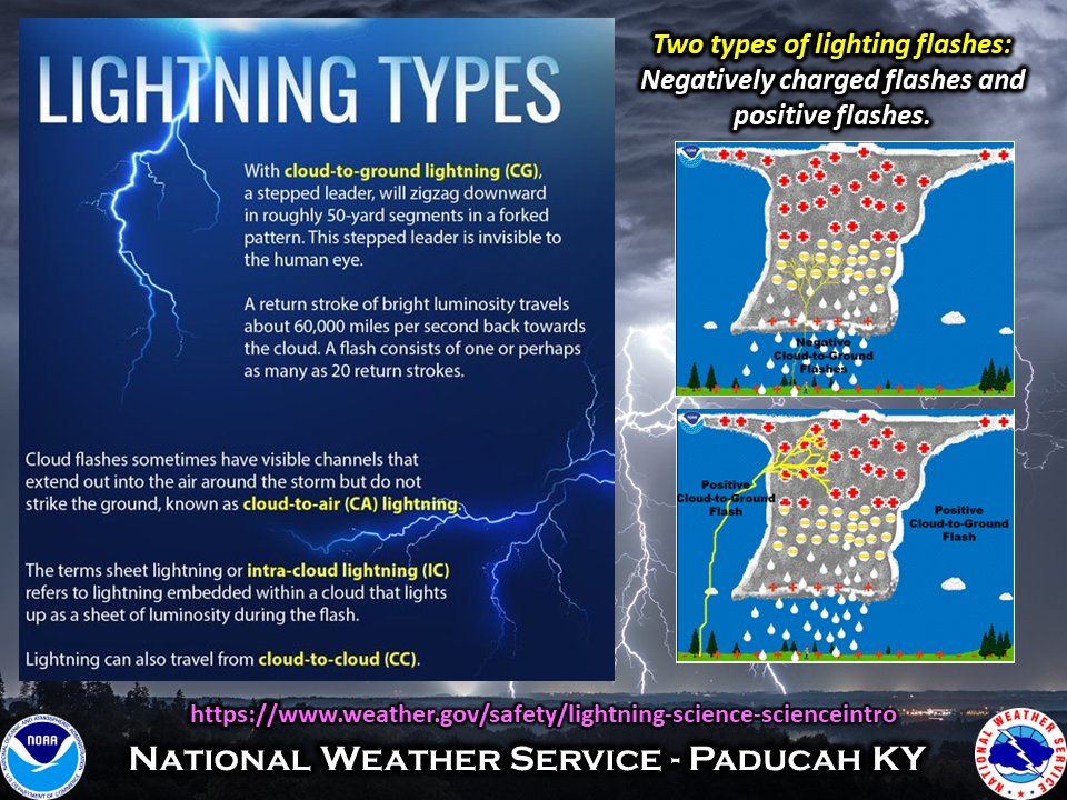
Dig deeper into lightning by learning about the types of lightning flashes along with negative vs. positive flashes by visiting this webpage: https://t.co/X5PlvyxCCL