🌍 World Environment Day 2026
What we measure accurately, we can better understand - and protect in the long term.
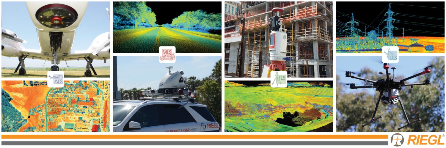
With innovative #LiDAR technology, #RIEGL supports users worldwide in this task.
UN Environment Programme:
https://t.co/ppO4Ovdvhv
The challenges of our time call for well-informed decisions. Whether it’s environmental monitoring, resource management, or ecosystem observation - reliable #geospatial data provides the foundation for making changes visible and documenting developments over the long term.
🎤 A key highlight has been the #RIEGL presentation:
“Utilizing the #RIEGL VZ-600i to leverage productivity without sacrificing accuracy – static and mobile scanning from one instrument".
Highlights from #GEOBusiness2026 - #RIEGL at Booth G232
#GEOBusiness2026 at ExCeL London has been an exciting and productive event, with the #RIEGL UK team on-site representing #RIEGL and showcasing the latest innovations in high‑performance #LiDAR technology.
Throughout the show, they’ve connected with geospatial professionals and showcased solutions across #UAV based, #Bathymetric, #airborne, and #mobile surveying applications.
A special thank you to Dr. Carlos Alberto Silva (University of Florida, Associate Professor of Quantitative Forest Science) and the ForestSAT Conference Committee for organizing a great event and field experience.
🎥 Check out #RIEGL’s #LiDAR solutions for forestry - captured live at Forestsat 2026 🌳
Get a preview of our latest #RIEGL Video Lab episode, produced by the #RIEGL USA team.
👉 Watch the full video now: https://t.co/XQXQ6o7Pjq
Why the #RIEGL VZ‑600i makes fieldwork easier:
🔸 25‑second scan time with image capture
🔸 70+ scan positions per hour
🔸 Instant switch to kinematic mode
🔸 Reliable performance in rugged environments
👉 “Want to learn more? At #GeoBusiness2026, discover how these workflows translate into real-world solutions and meet the #RIEGL UK team starting tomorrow at Excel London, booth G232. For more information: https://t.co/Q1R3w1FIdn
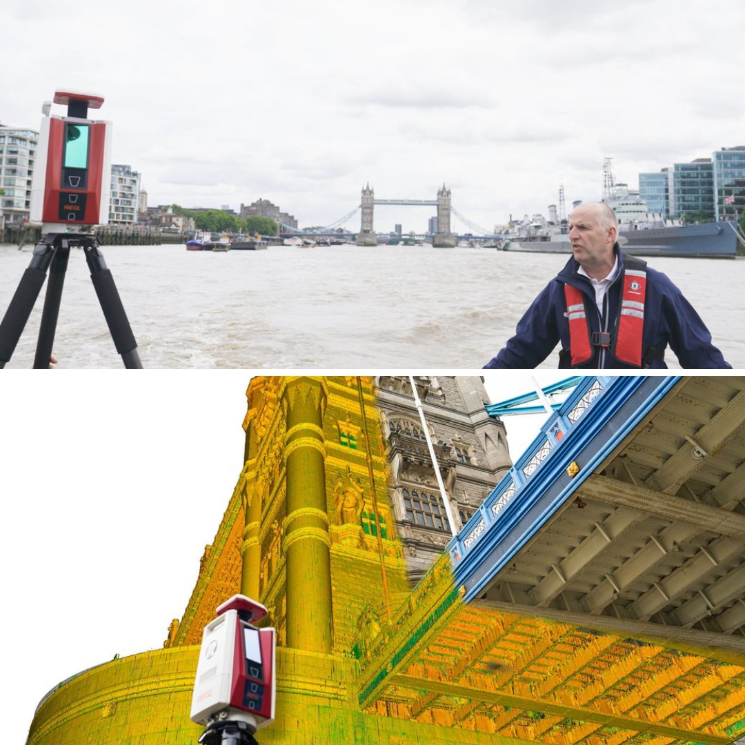
Kinematic Terrestrial Laser Scanning of the River Thames.
Read article ⬇️
https://t.co/1l0EXADA8H
A recent article in GIM International highlights how #RIEGL#terrestrial#LiDAR is being applied in a kinematic workflow to capture high-quality data in dynamic environments.
Led by #RIEGL experts Dave Foster (Managing Director, #RIEGL UK) and Bernhard Groiss (Application Engineer, #RIEGL Laser Measurement Systems), this project covered a 12 km section of the River Thames between Tower Bridge and Lambeth Bridge.
Reducing Power Outages with #Airborne#LiDAR and #AI: A Scalable Approach to Vegetation Management in Eastern Canada.
Read article⬇️
https://t.co/12Oh3Dpcwi
Featuring #GeoWeekNews, #EAASI & #XEOS, powered by #RIEGLLiDAR with the VQ-1460.
📖 Read the full article to explore how this research is shaping strategies for urban forestry, wildfire mitigation, and climate resilience: https://t.co/zDZdnrBP0n
After the Fires: Protecting LA’s Trees While Learning Lessons for the Future. Utilizing the #RIEGL VZ-400i Terrestrial Laser Scanner.
🎥 Watch the video to see how #LiDAR technology is being used to capture fire-affected landscapes in precise 3D detail: https://t.co/x8Vq0nmd4T
At #RIEGL, we’re committed to providing the data quality and reliability professionals need to make informed decisions in an era of increasingly complex environmental challenges.
For the second flight, the #UAV was equipped with the #RIEGL VUX‑160, illustrating its exceptional performance for high-density airborne mapping. Thank you to Nordic Geo Center, Acecore, and all who joined us for an engaging day of #LiDAR demonstrations in Northern Europe.
📍#RIEGL Multi-platform #LiDAR Demo in Tallinn.
The #RIEGL team gathered at the Kopli waterfront in Tallinn, Estonia’s capital on the shores of the Baltic Sea on the Gulf of Finland, for a live #LiDAR demo in collaboration with Nordic Geo Center, using an #Acecore#UAV platform.
In addition to #UAV operations, we showcased #kinematic scanning using the #RIEGL VZ‑600i, mounted in a backpack configuration - highlighting the flexibility of #mobile laser scanning for dynamic #terrestrial applications.