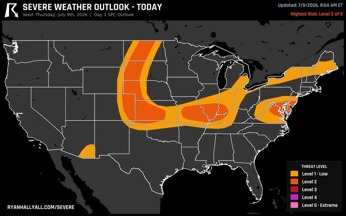
Level 2 of 5 today across a big stretch from Kansas and Missouri up into North Dakota.
Gusty, damaging winds are the main concern as storms clump together this afternoon. Up in North Dakota it's more of a hail play, with a couple stronger storms possible. Around Columbia, MO the busiest window runs 2-10 PM, peaking near 4.
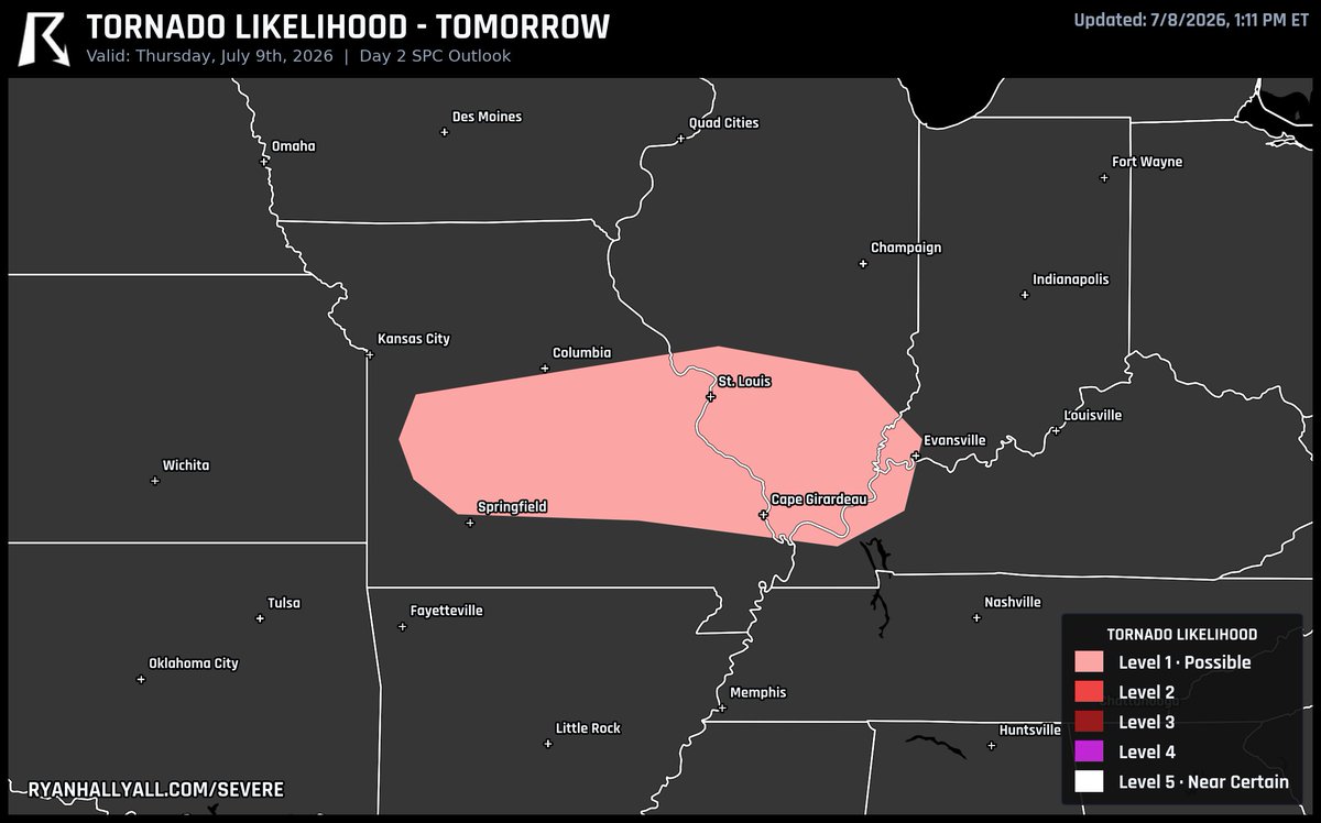
If you're anywhere around Evansville, IN, Cape Girardeau, MO, or Paducah, KY tomorrow, you're sitting in the zone with the best shot at a tornado in the country.
It's a Level 1 risk, so a low-end chance, but that's where the odds run highest.
😈 This isn't just an update, it's innovation.
Our biggest models update yet is now live.
Open WeatherWise and explore everything that's new.
🎥 Full walkthrough/tutorial coming by Friday evening.
See thread below!
That Colorado high country setup I mentioned this morning got a bump up to Level 3 of 5.
Storms fire off the mountains this afternoon, then clump together and bow out with the strongest wind gusts on the northeast Colorado and northwest Kansas plains. Around Colby, KS the rough stretch runs 4 PM to midnight, peaking near 7.
Level 2 of 5 tomorrow across parts of Kansas, Missouri, and Colorado. Storms fire off the Colorado high country in the afternoon, then bunch together and roll east overnight with gusty, damaging wind the main worry. Out in southwest Kansas a cluster could hold together late into the night, so heavy downpours may pile up too.
Take cover now, Mora. Radar-indicated tornado near central Kanabec County, tracking east at 30 mph until midnight CDT. Mora, Mora Airport, and Quamba are directly in the path. Tornadoes are hard to see at night. LIVE: https://t.co/IJvaCVSyzZ
The most likely place in the USA to see a tornado tomorrow is around Green Bay, WI, Algona, IA, and Charles City, IA.
It's a Level 1 risk for tornadoes, so a low-end chance, but that's where the odds are highest.
Level 2 of 5 today across parts of Montana, South Dakota, and Minnesota.
Storms start out west this afternoon with hail, then the winds crank up after dark and pull everything into a line that can gust hard as it heads east. Around Alexandria, MN the roughest stretch runs into the late evening, peaking near 10 PM.
Confirmed large, extremely dangerous tornado on the ground near Rochert in central Becker County, MN. This is a PDS. Basement or lowest interior room, right now.
PDS Tornado Warning, southeastern Becker County, Minnesota. Spotters have confirmed a large, extremely dangerous tornado near Rochert and Detroit Lakes moving east at 40 mph. Get to a basement or lowest interior room right now.
Northeastern Dare County, including Manteo, has a Tornado Warning until 4 PM EDT. Radar rotation over Croatan Sound, nearly stationary west of Manteo. Take cover now. We're LIVE: https://t.co/IJvaCVSyzZ
Level 2 of 5 today in two spots: the eastern Dakotas into western Minnesota, and central Virginia. Up north the early storms can drop hail bigger than a golf ball, then merge into a line that gusts hard. Around Fargo, ND the busiest stretch runs 2-11 PM, peaking near 4.
🚨 You're looking inside one of the strongest storms on Earth.
This is Super Typhoon Bavi approaching Guam. On the left is rainfall intensity. On the right is radar velocity, showing the incredible winds rotating around the eye.
The tighter those colors are wrapped around the center, the more intense the circulation. Winds near the core are expected to reach around 180 mph, making this a Category 5-equivalent super typhoon.
Nature doesn't get much more powerful than this.
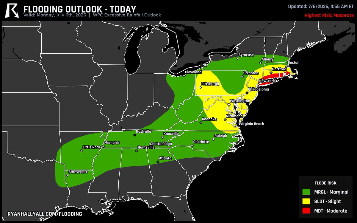
Moderate flood risk from WPC today for Connecticut, Rhode Island, and parts of southeast New York. The zone runs from around Hartford down to Providence and out past Long Island's south shore. Slow, heavy downpours can stack up fast here, so watch for flooded streets and low spots this afternoon.
That flood risk from this morning just got bumped up. WPC now has a Moderate risk for tomorrow across northern New Jersey, New York City into Long Island, and eastern Pennsylvania near Allentown. Downpours over crowded, paved-over metro areas back up fast, so build in extra time on Monday and turn around if a road is underwater.