South Dakota, Illinois, and North Dakota sit under a Level 2 risk today, and damaging wind is the main hazard, with large hail possible too. The Chicago area's best window for wind runs into the evening hours, peaking around 8 PM, while a separate batch of storms over the Dakotas could bring its own round of wind and hail later today.
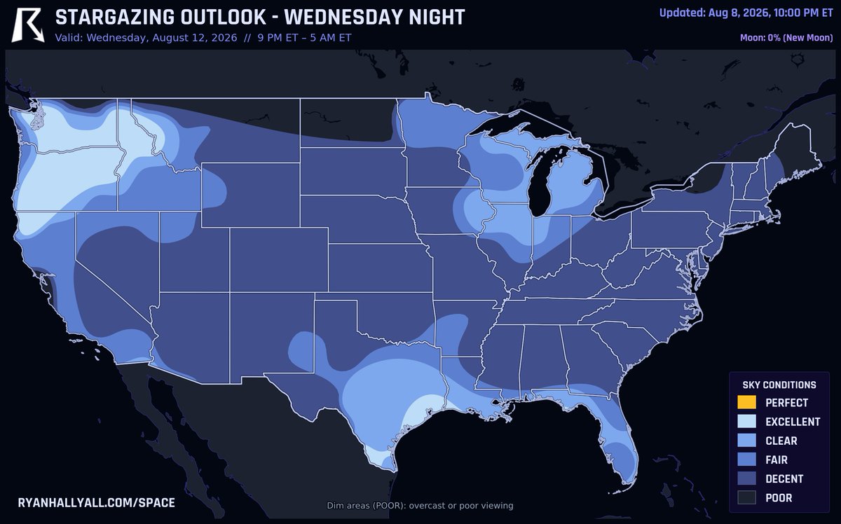
NEW MOON MEETS PERSEIDS PEAK Wednesday night!
The moon goes fully dark that night, and it happens to line up with the actual peak of the Perseids, one of the best meteor showers of the year. With next to no moonlight in the way, you've got a real shot at some fast, bright meteors if skies cooperate. Early read favors the Pacific Northwest and Texas, think Seattle, Portland, and Houston, but it's still three nights out so check back as we get closer.
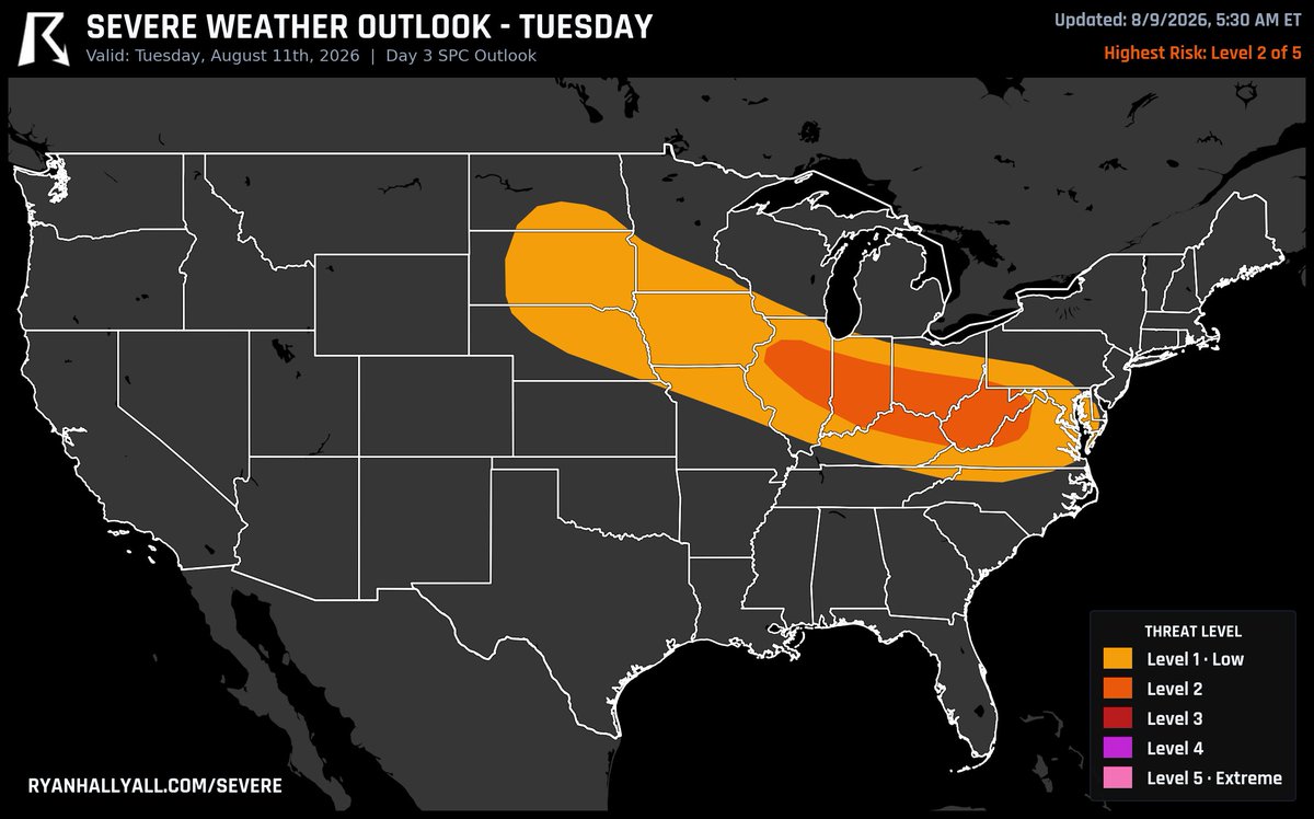
Tuesday's severe threat over Indiana, Illinois, and West Virginia is up to a Level 2 risk. Leftover storms from the day before should leave behind a boundary that reignites into a cluster of strong to severe storms as it slides into the Ohio Valley that afternoon, and damaging wind gusts look like the main worry if that cluster holds together into the evening.
Two separate storm zones show up on Wednesday's map.
SPC has a 15% severe risk stretching from western Nebraska all the way to the mountains of Virginia and West Virginia, with damaging wind the main worry in both spots. Still three days out, so treat this as an early flag, not a lock.
PERSEIDS PEAK Tuesday night!
This is the actual peak of the year's best meteor shower, and it lines up with a new moon, so there's basically zero moonlight to wash things out. If skies cooperate you could catch a solid number of these fast, bright meteors an hour, no telescope needed, just find a dark spot and give your eyes a few minutes to adjust. Early look has decent clear-sky odds for spots like Houston, Tampa, and LA, but that's still a few nights out so keep checking back.
New Jersey, Pennsylvania, and Maryland sit under a Level 2 risk today, and it's really a wind story: clusters of storms could push out gusts of 50 to 65 mph as they roll through this afternoon. Baltimore and Aberdeen look busiest right around 3 PM, with some hail also possible near Maryland's Eastern Shore.
Monday's storm threat over Ohio, Illinois, and Indiana just moved up to a Level 2, one step above where we had it yesterday.
A stalled front will kick off storms near northern Illinois by afternoon, and with muggy air already in place to the south, damaging wind gusts look like the main concern as those storms cluster together into the evening.
The most likely place in the country to see a tornado tomorrow is around Chicago, Rockford, and Cedar Rapids. SPC has that risk marked Level 1, the mildest step on their scale.
Buchanan County, Iowa is under a Tornado Warning until 5 PM CDT, confirmed tornado on the ground near Otterville and Independence, moving southeast at 45 mph. Winthrop, Quasqueton, Rowley and Monti in its path with 2 inch hail possible. Basement or interior room now, away from windows.
Take cover now: a confirmed tornado is tearing across southwestern Fayette County, Iowa, headed for Oelwein by 4:15 PM CDT. Warning stands until 4:30 PM CDT, half dollar hail possible. Get low, get away from windows. https://t.co/IJvaCVSyzZ
A Level 2 severe risk covers Pennsylvania, Maryland, and New Jersey today, with damaging wind gusts up to 60 mph the main threat as storm clusters push through the I-95 corridor this afternoon and evening. Philly and Baltimore look worst from 3 to 9 PM, peaking near 5, while New York and Newark's window runs a bit later, 5 to 10 PM with a 7 PM peak.
Marking Monday on the map.
SPC has a 15% severe risk penciled in over Ohio, Illinois, and Indiana, mainly for damaging wind gusts from clusters of storms. Four days out, so this is an early flag, not a lock.