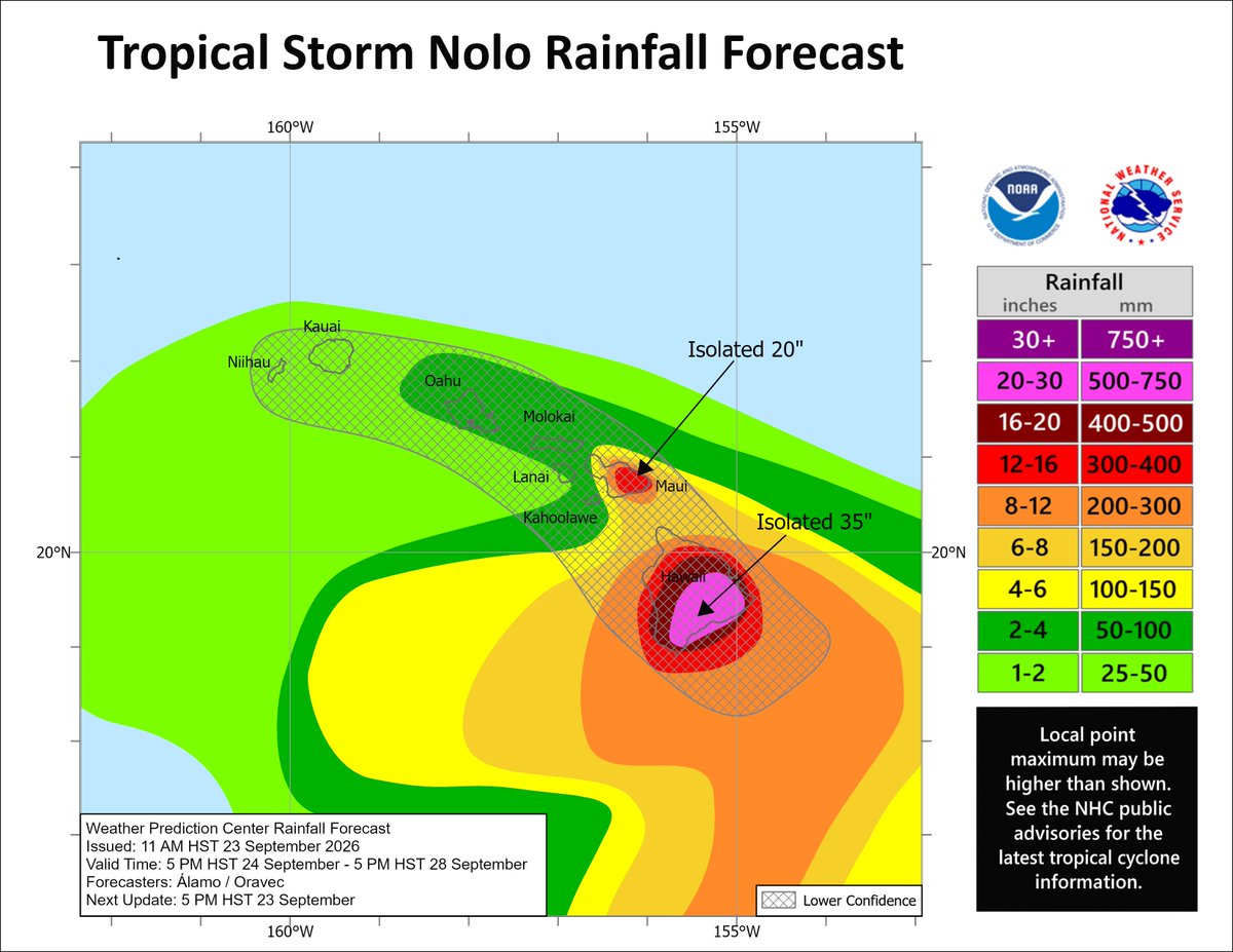
Crazy to see yet another hurricane threat to #Hawaii this season. Tropical Storm #Nolo has formed and will intensify into a potentially strong hurricane to the south of the Big Island over the next 3 days within a favorable environment. Complex steering currents will likely bring Nolo close enough to the Big Island to cause at least severe flooding concerns, and possibly wind hazards if it gets too close. A Hurricane Watch has been issued for the island. The other islands aren't out of the woods either, with uncertainty in the forecast track leaving a small possibility of a closer brush with Nolo. Hope everyone has a plan ready to go after dealing with Lala and Lowell earlier this year.
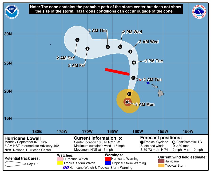
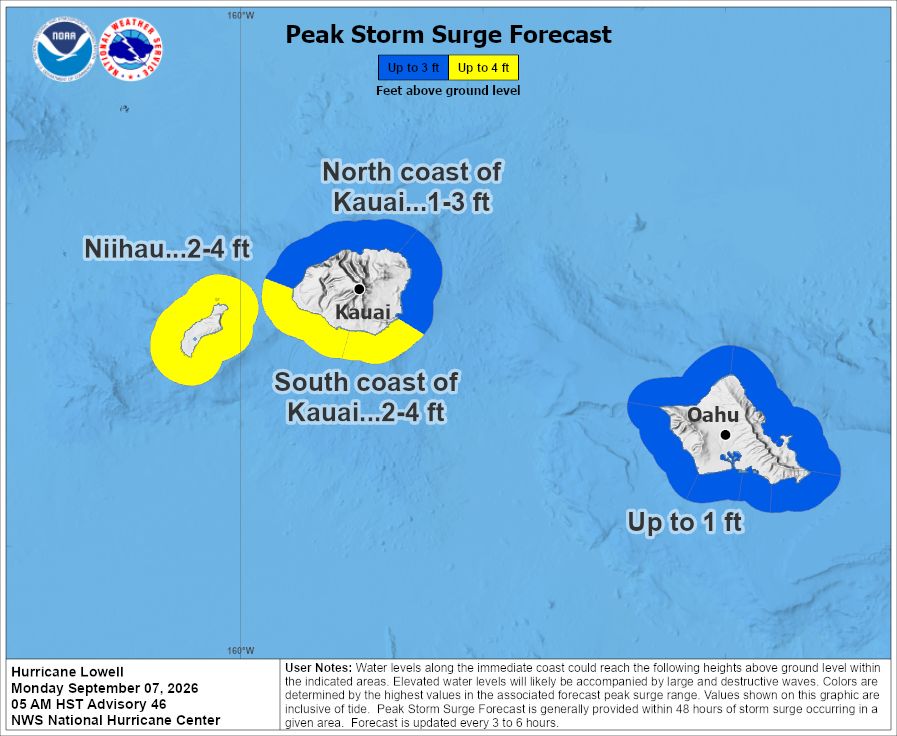
Hurricane #Lowell is approaching the Hawaiian Islands today with a wind field large enough to impact #Kauai, #Niihau, and #Oahu. A Hurricane Warning now extends to Kauai, and a Tropical Storm Warning to O'ahu. The worst conditions will occur later this evening and overnight tonight. Storm surge and flash flooding hazards are also expected, especially closer to the storm track. Hope everyone has a plan to stay safe today.
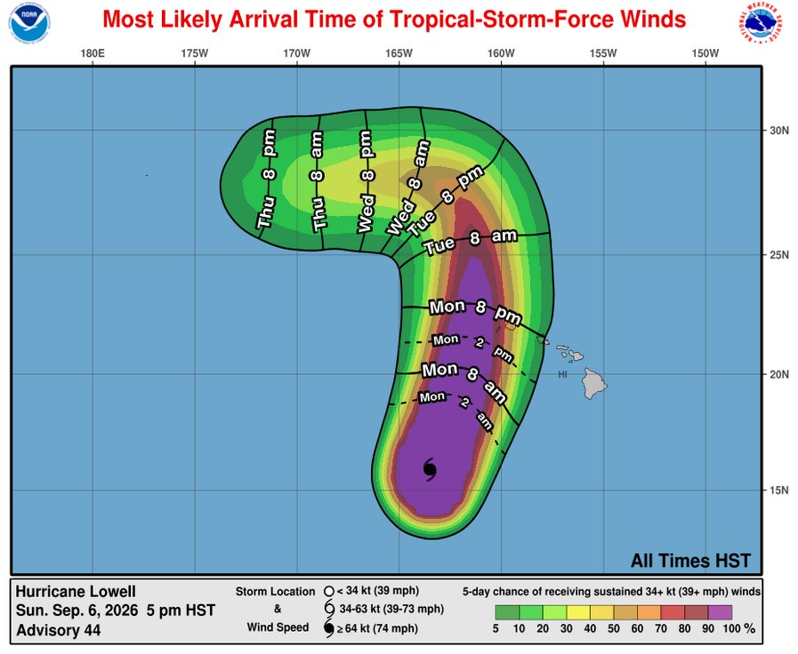
Watching Hurricane #Lowell move toward its brush-by of the main Hawaiian Islands tomorrow, likely bringing dangerous conditions to #Kauai, where a Tropical Storm Warning and Hurricane Watch are in place. Hope everyone stays safe in Kauai and the outlying islands to its west.
Some outer bands may also bring high wind gusts and downpours to #Oahu, where I will hope for no power outages.
Watching Hurricane #Lowell and hoping the primary islands of #Hawaii can avoid a major hit.
One trend to watch: whether models' ongoing southward correction for the short-term track continues. Most guidance has shifted the westward track leg closer to the monsoonal belt (pink) and farther from the trade winds (yellow). Too much of that trend would slow Lowell down, forcing the northward turn to occur farther east increasing risk to the main Hawaiian Islands. Ensemble correlation analysis confirms this sensitivity (thanks @burgwx for the 2nd plot).
There remains significant uncertainty, and the storm is several days away, but it is smart to have a plan just in case. I've already dusted mine off more this year than I would have guessed.
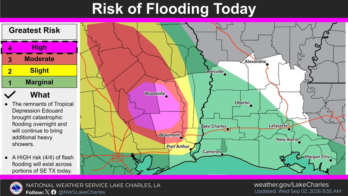
Tropical Depression #Edouard has unfortunately produced more rainfall than expected as it tracks inland, with storm total reports peaking as high as 16-20 inches in some spots. A Flash Flood Emergency was issued for portions of Hardin and Tyler counties in eastern Texas earlier this morning as severe flooding was observed in the region. High flooding risk continues today, with Flash Flood Warnings still in effect for Liberty, Polk, Hardin, Jasper, and Tyler counties as of this hour. Hoping folks stay safe today.
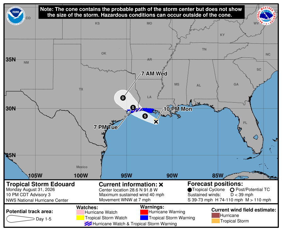
Tropical Storm #Edouard made landfall earlier along the far western #Louisiana coastline with Max winds around 60 mph, and is now moving inland near Beaumont, #Texas. While the storm will now weaken fairly quickly, some flooding and wind alerts from the National Weather Service remain in effect. Stay safe and smart today.
🌀 Quick update on Tropical Storm #Edouard, strengthening as it approaches landfall in the border region of #Texas and #Louisiana.
🌀 Be safe and smart today if you're in the path of hazardous conditions, especially near the coastline. @NWSHouston and @NWSLakeCharles have the details for your local area.
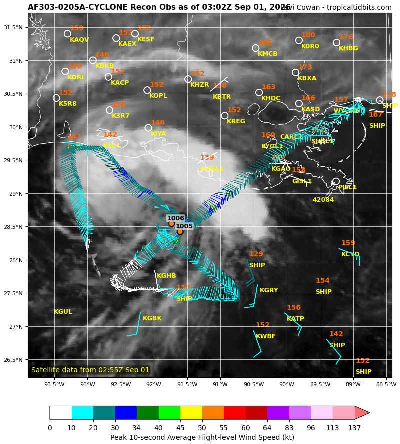
We now have Tropical Storm #Edouard in the Gulf with max winds of ~40 mph. A recon aircraft found that the central pressure fell considerably to ~1005 mb during the day, associated with a tight and well-defined core wind field. The storm's central convection has waned somewhat in recent hours, which will likely stall intensification until a new burst of thunderstorms ignites.
The compact nature of the wind field increases the risk of Edouard gaining a quick rush of strength before landfall in eastern #Texas or western #Louisiana tomorrow, as small storms are more prone to rapid intensity changes. Accordingly, @NHC_Atlantic has issued a Storm Surge Warning and a Hurricane Watch along portions of the coastline.
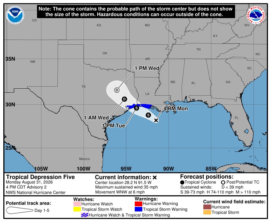
Tropical Depression 5 (#TD5) is maintaining a central cluster of thunderstorms even into the diurnal convective minimum, indicating its local environment is becoming more conducive to intensification. Earlier recon aircraft data also suggested a compact inner core wind field may be forming, which would also support quick intensification.
The updated @NHC_Atlantic forecast has significantly raised the forecast intensity peak to 60 mph max winds, with an associated increase in coastal storm surge risk.
This evening's planned 00Z recon mission will confirm whether a phase of quick intensification is beginning.
🌀 Monday video update on the new storm developing in the Gulf which will impact portions of eastern #Texas and western #Louisiana on Tuesday and Wednesday.
🌀 The National Hurricane Center has initiated advisories on "Potential Tropical Cyclone Five" (#PTC5), which will acquire the name #Edouard if it strengthens into a tropical storm.
🌀 Sunday afternoon video update on a new tropical disturbance in the Gulf expected to impact portions of #Texas and #Louisiana, and the remnants of Tropical Storm #Dolly near #PuertoRico
The remnants of #Dolly are approaching the #LeewardIslands today, where strong winds and heavy rains will occur in some islands tonight, spreading to the #VirginIslands and #PuertoRico on Monday.
The wave remains vertically decoupled due to westerly shear, with the mid-level vorticity (spin) maximum displaced well ENE of the surface vorticity maximum.
Dolly's remnants will be monitored later next week as they track west-northwestward through the Bahamas region and potentially the Gulf, in case environmental conditions make regeneration possible. At the moment, this appears to have a low probability of occurring, but is worth monitoring.
Tropical Storm #Dolly has formed in the eastern Atlantic from the tropical wave previously known as Invest 96L. A west-northwestward track towards the Leeward Islands of the Lesser Antilles is expected through this weekend.
While a well-defined circulation is evident in satellite imagery, Dolly's currently anemic levels of deep convection foreshadow unfavorable environment ahead, consisting of a generally dry air mass east of the Caribbean and higher levels of westerly/southwesterly shear as the storm nears the #LesserAntilles. Models are thus bearish on Dolly's near-term future, as is the first official NHC forecast, showing likely dissipation of Dolly near or east of the #LeewardIslands.
If Dolly does dissipate, its remnants would be similar to a strong tropical wave that could still bring heavy rains and gusty winds to portions of the northeastern Caribbean, including #PuertoRico. Residents in the region should monitor the forecast over the rest of this week.
A tropical wave leaving Africa has a decent chance to become a tropical storm as it tracks across the eastern and central Atlantic this week. Dubbed "Invest #96L," its surroundings generally favor development short-term, as the Saharan air mass to its north is less dry and deep than usual. Models agree on a west-northwestward track that would bring the system near or north of the Lesser Antilles in 6-7 days.
96L will likely encounter a less favorable environment later in the week as it nears a persistent zone of elevated wind shear over the central Atlantic. While earlier waves have been destroyed entirely by this zone, it is now peak hurricane season, so waves like 96L may survive long enough to get through the zone. It's too early to know whether 96L will stick around beyond this week, but it is a system to watch. The National Hurricane Center currently gives 96L a 60% chance of becoming a tropical cyclone.
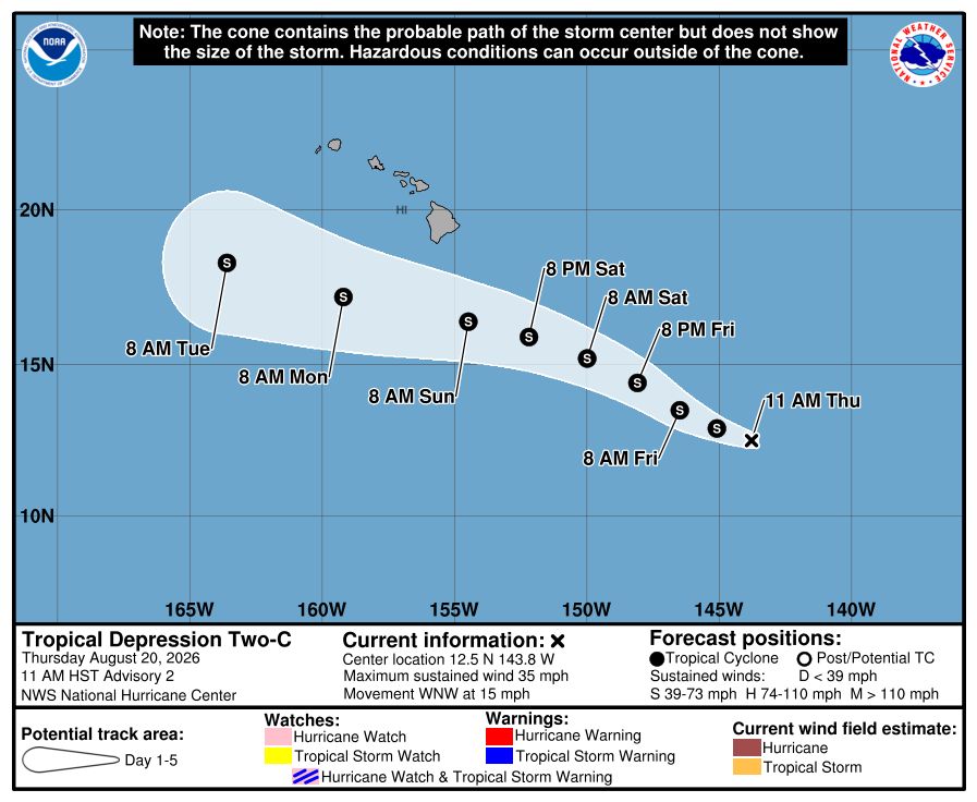
Tropical Depression Two-C (#TD2) continues to track west-northwestward to the southeast of #Hawaii. Satellite imagery shows you how the easterly trade winds in the lower atmosphere switch to southerly winds at higher altitudes, creating vertical shear that is pushing thunderstorms away from TD2's center of circulation towards the north. This shear is expected to persist over the next 3 days and hold TD2's intensity below hurricane threshold.
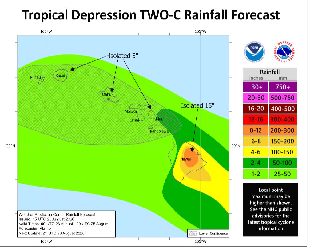
Heavy rains and gusty winds may still occur in the Big Island of Hawai'i this weekend, where a Flood Watch is in effect. @NWSHonolulu notes that "it will not take a significant amount of rain to cause flash flooding due to saturated grounds from recent heavy rains [from Lala]." Everyone stay safe this weekend.
Tropical Depression "Two-C" (TD2) has formed southeast of #Hawaii. It will be named "Moke" if it strengthens into a tropical storm. Some adverse environmental conditions are expected to keep TD2 below hurricane intensity as it tracks west-northwestward over the rest of the week.
Models are coming into better agreement on TD2 tracking south of the Hawaiian Islands, but the key will be exactly how distant. Heavy rains and strong wind gusts may still occur in at least the Big Island, and any track shift to the north would worsen expected impacts. Residents should be prepared for additional flash flooding and landslide potential this weekend. Hoping for more southward shifts! Stay tuned to the National Hurricane Center and NWS Honolulu for expected impacts.
🌀 The Central Pacific won't calm down. As Hurricane #Lala moves on after thrashing #Hawaii last weekend, another system (dubbed Invest #90E) is lurking behind, poised to soon develop and move into the vicinity of the Hawaiian Islands.
🌀 Environmental conditions may be a bit less favorable for 90E than they were for Lala, but the steering flow could feasibly carry it along a similar trajectory to Lala, approaching from the southeast, and the storm could track close enough to cause impacts to the Big Island as soon as Saturday night, then spreading westward.
🌀 Residents in the islands should be prepared for a potential second round of hazardous conditions if this new storm passes too close. Keep a close eye on the forecast from the National Hurricane Center and NWS Honolulu this week.
It's definitely an exceptional El Niño event and we are seeing its fingerprints on the hurricane season. It's not surprising that the Pacific is active and the Atlantic is quieter than normal so far. Of course, that doesn't guarantee an Atlantic storm won't develop and cause impacts at some point. We are only just now entering the climatological peak of the Atlantic season.