We have moved all USGS Land Cover updates to the @USGS_EROS account! Don't forget to follow us there to stay connected and hear about exciting #LandCover news and announcements. Find USGS EROS on Instagram and Facebook too.
We have moved USGS Land Cover content to the @USGS_EROS account. Don’t forget to follow us there to hear about exciting land cover news and announcements. Find USGS EROS on Instagram and Facebook too.
https://t.co/zQ7xI7ugXY
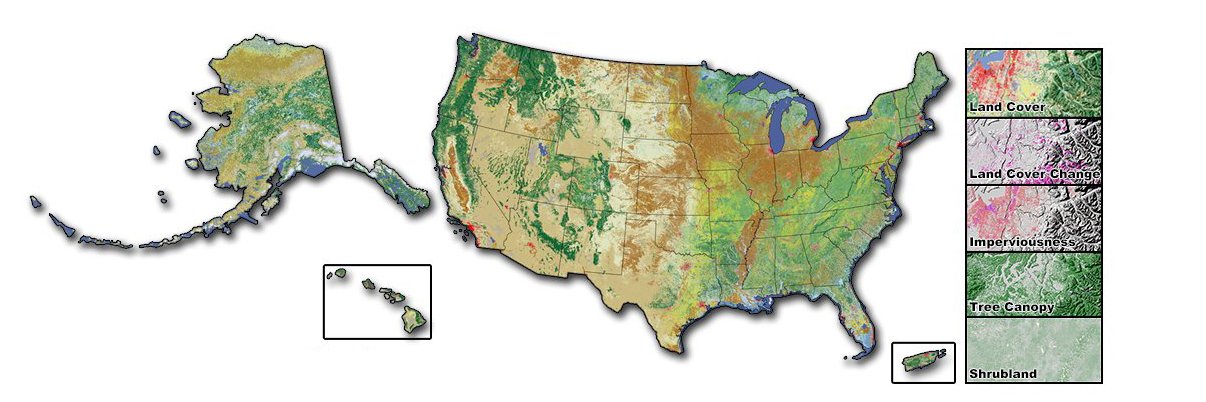
Annual NLCD, slated to be released #Fall2024, will revolutionize #LandCover and #LandCoverChange assessments by providing a suite of six annual data products for the conterminous United States from 1985 to 2023. Stay tuned for more details! #ImperviousSurfaces#Innovation
The USGS Land Cover account is closing soon. To stay connected and learn about the latest #LandCover updates, follow us at @USGS_EROS. Find USGS EROS on Instagram and Facebook too.
https://t.co/HuQZZ0XsBh
In case you missed our exciting land cover announcement last month, we are thrilled to share it again. Coming this fall, the next generation of land cover and change products, known as Annual NLCD, will be released. Learn more here: https://t.co/k0DvHhb05k
Important reminder! The USGS Land Cover account is closing soon, but we will be posting content on the @USGS_EROS account. Stay connected to hear about exciting #LandCover updates and announcements.
https://t.co/Tv7eiJUH5J
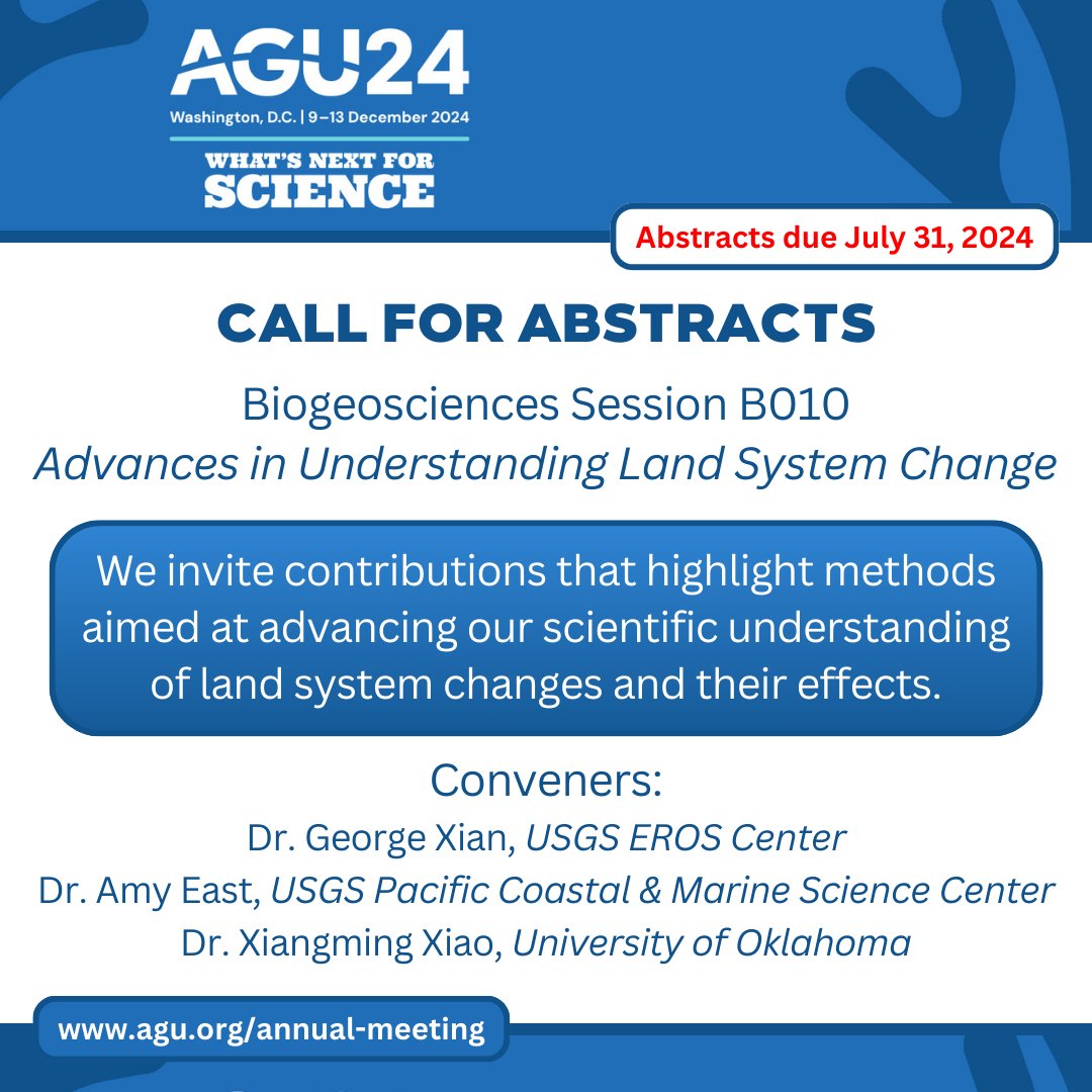
Abstracts for #AGU24 are due by July 31! Consider submitting a presentation under Session B010 – Advances in Understanding Land System Change to showcase your #LandChangeScience and #RemoteSensing research. Learn more here: https://t.co/GTqUCmEvie
Important update for our followers! This account is closing soon, but there are plenty of ways to stay connected. For the latest and greatest on land cover, follow us at @USGS_EROS. Find EROS on Instagram and Facebook too!
https://t.co/lgLWj2i8AV
Exciting news for #NLCD users! We are working hard to bring you a major update: Annual NLCD. Coming this fall, annual #LandCover products will be released for the conterminous #UnitedStates from 1985 to 2023. Learn more here: https://t.co/3z5NeGvcU3
#LandCoverChange#DataRelease
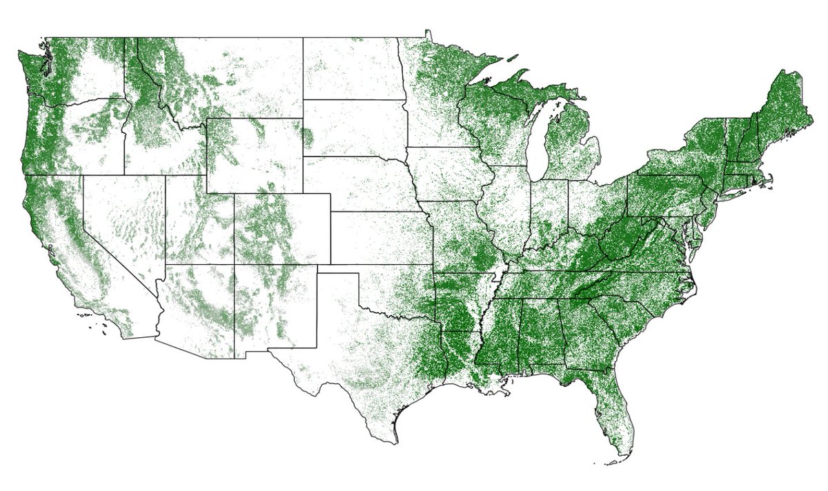
Planting a tree for #ArborDay? Our satellites are mapping trees nationwide 🌳 to aid land cover research. This canopy data from @forestservice with #Landsat images is just one layer on the National Land Cover Database supporting environmental research: https://t.co/7LBJFBbGft 🛰️
The latest #RCMAP data release highlights updated projections of rangeland vegetation cover. These datasets will allow land and resource managers to assess the impacts of #ClimateChange on #RangelandEcosystems. Learn more here: https://t.co/SScBRm1eW9
👀 New Pub! Thematic accuracy assessment #NLCD 2019 CONUS land cover paper has published! Overall results are consistent with previous NLCD land cover accuracy assessments. Have a look at this research article by Wickham et. al. 2023 to find out more! https://t.co/g4SgxXNAmW
New EROS science lead Terry Sohl: “Overall, we're trying to look at the landscape, look at how it changes, look at the causes and the drivers of that change and then try to identify what the consequences are for society.”
Eyes on Earth podcast episode: https://t.co/43mnWSSqTp
Hear about Terry Sohl’s passion for remote sensing science and birdwatching in our latest Eyes on Earth podcast episode with the newly named leader of EROS science: https://t.co/LgwOxVOt9z
NLCD 2023 Sneak Peak!
Based on Landsat Collection 2, NLCD 2023 will offer annual products from 1985-2023. Depicting urban growth for the Atlanta area, this animation shows a single Landsat U.S. ARD tile of Anderson Level II #LandCover. https://t.co/THeHPq0ueT
For additional info, take a look at the Science version that includes model uncertainty metrics and predictions of standard error. https://t.co/okFikPrhF4
Tree Canopy Cover (TCC) layers for the continental United States, coastal Alaska, Hawaiian Islands, Puerto Rico, and the U.S. Virgin Islands for the years 2011-2021 are on the MRLC #NLCD Map Viewer. Check it out! https://t.co/8w22MiWI4v
Three new draw styles available for the Data Download Tool in the MRLC Rangeland Viewer! Now you can draw a custom polygon right on the map, upload a shapefile that specifies your area, or enter a GeoJSON string to define the extent. #RCMAP https://t.co/Sq7fQQfIBa
Now there are three new ways to download your data on the MRLC #NLCD Map Viewer plus tutorials! In addition to drawing a simple box on the map, you can draw your own shape, use a shapefile you upload, or enter a GeoJSON string that defines your area. https://t.co/rjOWNONSql
Here’s to 30 more years #NLCD! Building on this legacy through recent advancements in artificial intelligence and high-performance computing, the next generation will release annual land cover maps to support long-term land resource monitoring capability. https://t.co/aYx9l5GSEs
NLCD is a recognized leader in the land cover field. Its land cover is rigorously validated for accuracy, and NLCD is making these validations more easily accessible. A set of accuracy assessment points is now available with NLCD 2019 data: https://t.co/0uT9luRnVg
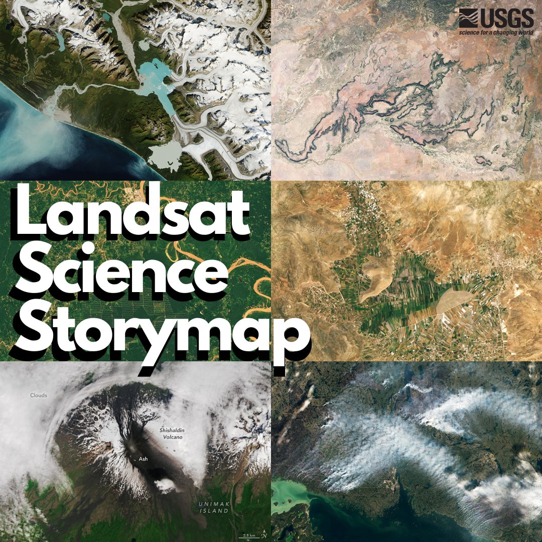
For more than 50 years, #Landsat has documented the evolving conditions of our planet. This storymap shows how Landsat benefits #agriculture, #glaciers and #ice, #H20 quality, #forest management, #fire, #urban sprawl, and now #volanos! Check it out here: https://t.co/f9ShQSVyjm
A new machine learning filter helps LANDFIRE monitor disturbance—change in landscapes. SAFER was trained using years of human-reviewed data and improves accuracy and speed, so fire first responders get crucial data faster. Learn more here: https://t.co/NpJdHSVEqc
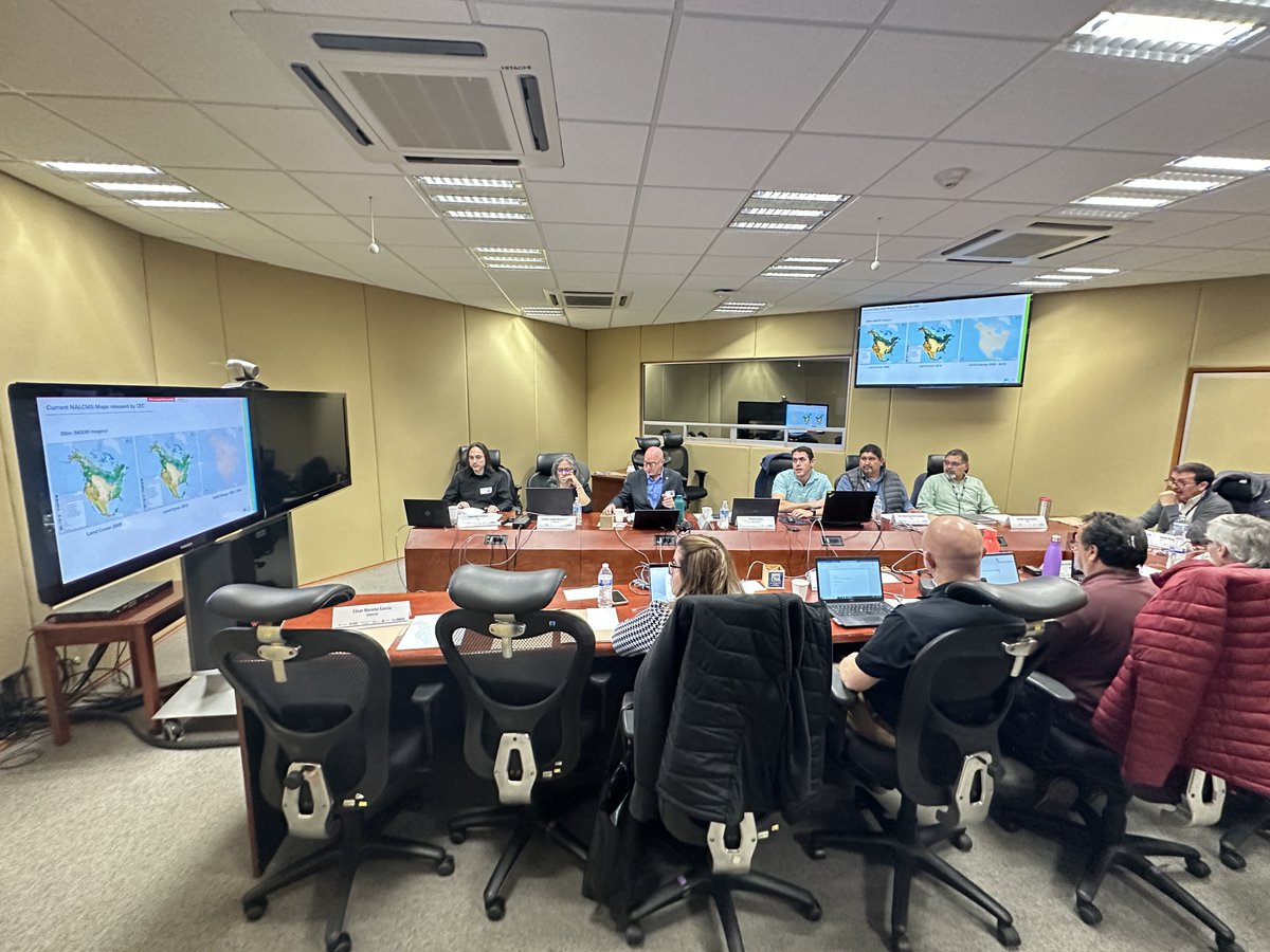
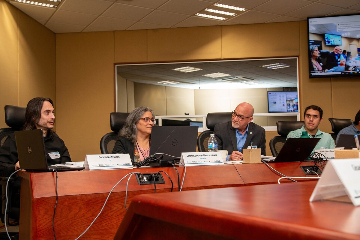
Last month, the North American Land Change Monitoring System (NALCMS) met in Aguascalientes 🇲🇽 to discuss & enhance the North American Land Cover & Land Cover Change #geospatial datasets available in the North American Environmental #Atlas
👉https://t.co/M2bUg4Yt30