We are expecting rain today on already saturated ground, this may lead to high water and road closures. Please Turn Around, Don't Drown! Here is a catchy song to help you remember!
https://t.co/0Q4Mz0lQid
Given the already saturated ground conditions, we are concerned about high water due to rainfall coming into the area tomorrow. Remember do not drive through high water! Turn Around, Don't Drown!
[2:10 PM] Multiple rounds of rainfall are expected from the early morning hours Wednesday through Wednesday night.
Be prepared for rises in creeks and streams, along with renewed flooding issues.
[4:23 AM] Very warm conditions are expected today, with high temperatures near record values, and wind gusts of up to 35-45 MPH.
Scattered thunderstorms are possible today, with the greatest chances near and north of Interstate 70. Some storms could produce damaging winds.
⚠️ Severe weather possible tonight. Be ready.
• Stay weather aware
• Know your safe place
• Secure outdoor items that could become dangerous in high winds
• Have multiple ways to get alerts
• Check in with family and make sure everyone knows the plan
Don’t wait—prepare 🌪️
[5:26 AM] Storms will develop and move southeast through the area tonight. There is the potential for large hail and damaging winds as well as an isolated tornado. The greatest chance for severe weather will be near and north of I-70. Locally heavy rainfall is also possible.
[5:54 PM] Severe Thunderstorm Watch issued for the counties highlighted in pink. Watch is in effect now, but we expect a lull in activity until a complex of storms develops behind the cold front late evening. Primary threat is large hail given that the storms will be elevated.
Windy conditions are expected again through tonight, with non-storm-related gusts between 40-60 mph, particularly near/west of I-71 and I-75. The winds may briefly decrease around sunset for several hours before increasing once again in the hour or two ahead of the squall line.
🌧️ Rain is on the way!
Heads up, everyone — showers are expected in our area today and into tomorrow with more rain throughout the week. Make sure to grab your umbrella, allow a little extra travel time, and stay safe on the roads.
Stay dry and cozy! ☔
[9:10] Multiple rounds of rainfall expected as we head through the week. Rain moves into the region late this morning and continues throughout the day, with the heaviest rain arriving this evening into the overnight hours.
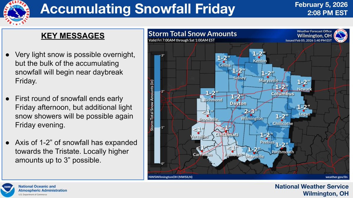
A band of snow will move in near daybreak Friday, with most of the accumulating snowfall expected Friday morning and afternoon. Expect impacts during the Friday morning commute. Additionally, bitterly cold air settles back in Friday night with sub-zero wind chills developing.
A winter storm will impact area this weekend, particularly late Saturday through Sunday. Although light snow will begin for parts of the area Saturday afternoon and persist through Saturday night, the heaviest snowfall is expected during the daytime Sunday.
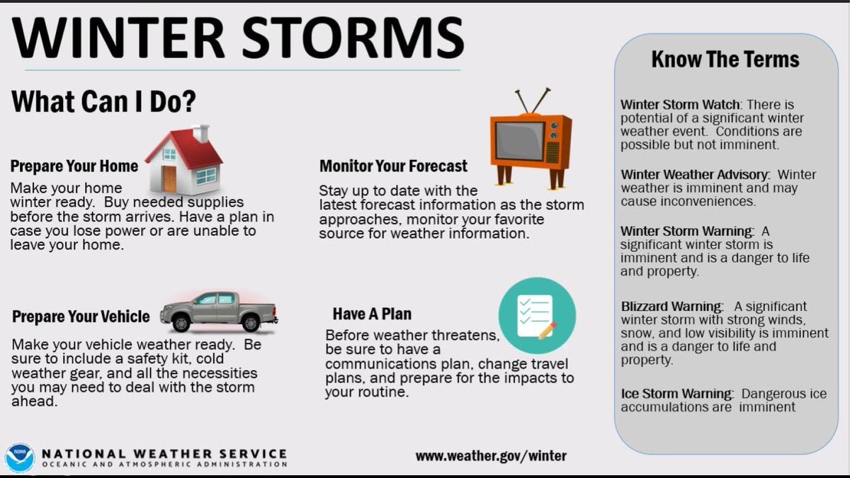
❄️ Winter Storm Prep Reminder ❄️
Prepare now in case of power outages or hazardous conditions:
🔋 Charge devices
🔦 Have flashlights & extra batteries
🥫 Food & water
💊 Medications
👶🐾 Essentials: pet and baby supplies
A little prep now goes a long way. Stay safe!
A winter storm is likely to impact the area this weekend. Here are some helpful tips to prepare for the storm. The greatest impacts are likely Saturday evening into Sunday.
[3:32 PM 1/21] Confidence continues to increase that our area will receive accumulating snow from Saturday through Sunday. A Winter Storm Watch is in effect for a portion of the area where this is most likely. Significant impacts to travel are expected where heavy snow occurs.
[3:27 AM] Gusty southerly winds are expected today, with the strongest gusts occurring between 11AM and 5PM. Rain is expected to move in by afternoon as well.
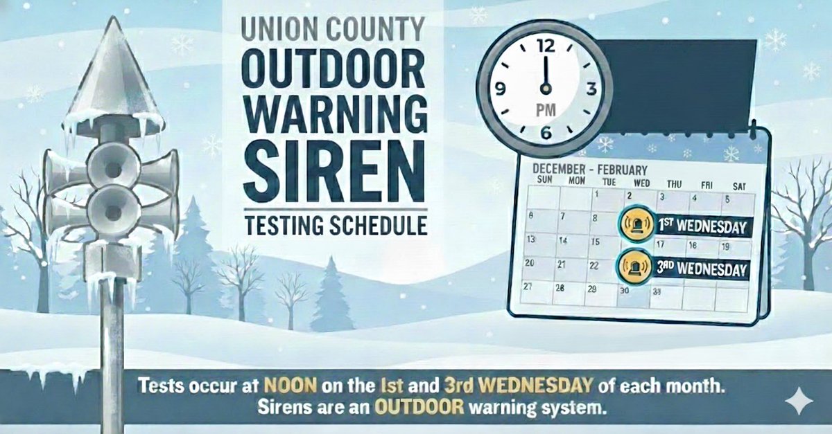
Union County will be testing the outdoor warning sirens twice a month from December through February; on the first and third Wednesday of each month.
From March through September, we will resume our regular weekly Wednesday noon siren testing schedule.
Let’s Talk Emergency Preparedness!
Union County Emergency Management Agency is here to help your group, or organization get prepared.
We’re happy to give a presentation on how to stay safe before, during, and after emergencies.
Let’s keep the preparedness conversation going!
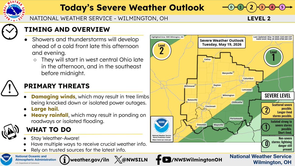
[9:20 AM] The Storm Prediction Center has upgraded parts of our forecast area to a slight risk (2 out of 5). A few strong to severe storms are likely this afternoon through early evening. Heavy downpours and gusty winds are the main hazards.

![NWSILN's tweet photo. [4:23 AM] Very warm conditions are expected today, with high temperatures near record values, and wind gusts of up to 35-45 MPH.
Scattered thunderstorms are possible today, with the greatest chances near and north of Interstate 70. Some storms could produce damaging winds. https://t.co/Tq0k9eugBX](https://pbs.twimg.com/media/HEubVryXMAAB-ub.jpg)

![NWSILN's tweet photo. [2:10 PM] Multiple rounds of rainfall are expected from the early morning hours Wednesday through Wednesday night.
Be prepared for rises in creeks and streams, along with renewed flooding issues. https://t.co/GziMSFOymK](https://pbs.twimg.com/media/HJQ8lbBWoAEgl4h.jpg)
![NWSILN's tweet photo. [4:23 AM] Very warm conditions are expected today, with high temperatures near record values, and wind gusts of up to 35-45 MPH.
Scattered thunderstorms are possible today, with the greatest chances near and north of Interstate 70. Some storms could produce damaging winds. https://t.co/Tq0k9eugBX](https://pbs.twimg.com/media/HEubXeEXYAAnHeM.jpg)


![NWSILN's tweet photo. [5:26 AM] Storms will develop and move southeast through the area tonight. There is the potential for large hail and damaging winds as well as an isolated tornado. The greatest chance for severe weather will be near and north of I-70. Locally heavy rainfall is also possible. https://t.co/FNHTvlPubr](https://pbs.twimg.com/media/HEU59EjbwAAdsbD.jpg)
![NWSILN's tweet photo. [5:54 PM] Severe Thunderstorm Watch issued for the counties highlighted in pink. Watch is in effect now, but we expect a lull in activity until a complex of storms develops behind the cold front late evening. Primary threat is large hail given that the storms will be elevated. https://t.co/RSZfq1kGQY](https://pbs.twimg.com/media/HEC-ptxW0AETUju.png)


![NWSILN's tweet photo. [9:10] Multiple rounds of rainfall expected as we head through the week. Rain moves into the region late this morning and continues throughout the day, with the heaviest rain arriving this evening into the overnight hours. https://t.co/KQqFwe0PUK](https://pbs.twimg.com/media/HCfgNHMWAAEct9O.jpg)


![NWSILN's tweet photo. [3:32 PM 1/21] Confidence continues to increase that our area will receive accumulating snow from Saturday through Sunday. A Winter Storm Watch is in effect for a portion of the area where this is most likely. Significant impacts to travel are expected where heavy snow occurs. https://t.co/44x5uC3t0R](https://pbs.twimg.com/media/G_NsbkzWYAAplJa.jpg)
![NWSILN's tweet photo. [3:27 AM] Gusty southerly winds are expected today, with the strongest gusts occurring between 11AM and 5PM. Rain is expected to move in by afternoon as well. https://t.co/BtCfwnRDfW](https://pbs.twimg.com/media/G8cAnsTXUAAAZql.jpg)

![NWSILN's tweet photo. [9:20 AM] The Storm Prediction Center has upgraded parts of our forecast area to a slight risk (2 out of 5). A few strong to severe storms are likely this afternoon through early evening. Heavy downpours and gusty winds are the main hazards. https://t.co/0PpLaGrvdw](https://pbs.twimg.com/media/G1dCGZdXIAAIXn9.jpg)