Hello My Name Is Jack Robertson And I Am A Certified Skywarn Storm Spotter. I am also Team Leader of Team Texoma Skywarn Network on zello. My 34th Year 2026
Some rainfall totals from the past 48 hours or so. Image shows the radar and rain gauge estimation of rainfall, while the numbers show the observed rain amounts. Too much for some, not nearly enough for most of us. #okwx#texomawx
Conditions start to dry out Monday, but with that will come increasing heat. Expect widespread high temperatures in the low to middle 90s by Tuesday and Wednesday of next week with peak heat index values in the 100 to 105 degree range. Prepare for the coming heat now.
Expect mild conditions and partly cloudy skies today, with isolated to scattered showers and thunderstorms possible this afternoon, as an upper-level trough shifts across the region. #arwx#lawx#txwx#okwx
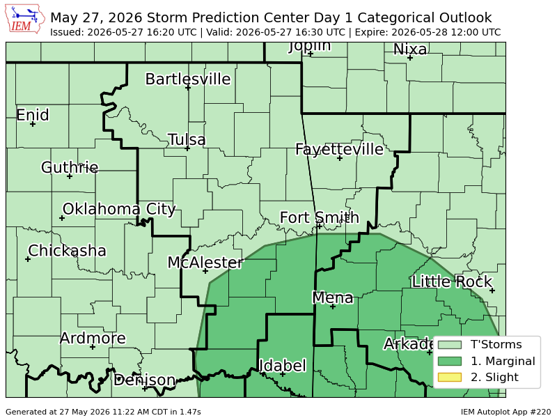
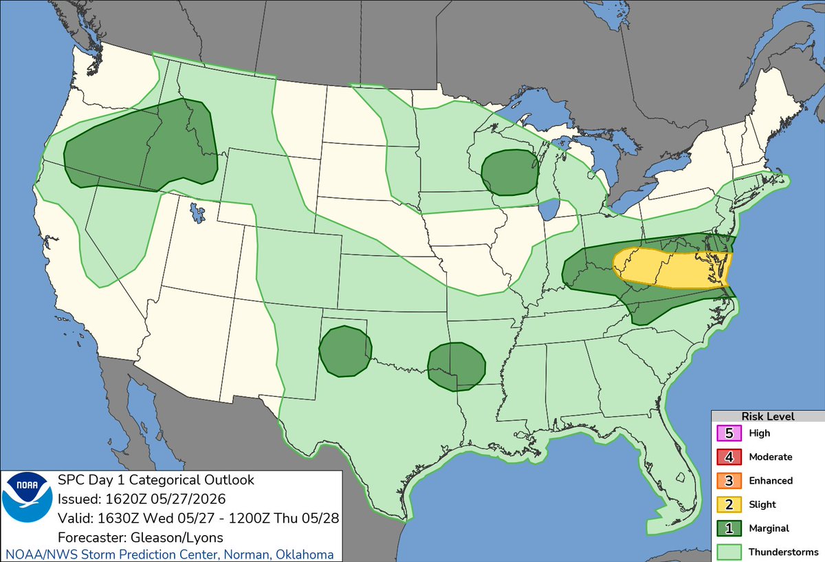
A Marginal Risk for a few strong to severe thunderstorms has been introduced for portions of the area. Main threats will be strong winds, but an isolated tornado also can't be ruled out.
[12:15 PM - 5/27/26] - Shower and thunderstorm chances will expand across eastern Oklahoma and northwest Arkansas today and tomorrow. Heavy rain and dangerous lightning are expected along with locally gusty winds. #okwx#arwx
At 10:15 AM CDT, 2 SSW Forney [Kaufman Co, TX] Emergency Mngr reports Flash Flood. Emergency Manager reported water on the roads in Melody Ln and Pecan Ln south of Forney. Water was reaching some of the homes. #txwx https://t.co/2VIBB5AwbU
At 11:48 AM CDT, 1 E Sachse [Dallas Co, TX] Emergency Mngr reports Flash Flood. Emergency Manager reported road closure of Sachse Rd at Country Club Rd due to high water. #txwx https://t.co/b7OUWk8Dpq
At 11:15 AM CDT, 4 S Trenton [Fannin Co, TX] Postal Employee reports Flash Flood. Public reported Water on roads near state highway 78 and 160 just west of Leonard. #txwx https://t.co/zOcA3pyY3w
At 11:00 AM CDT, 2 S Heath [Rockwall Co, TX] Local Official reports Flash Flood. Public official reported in social media road closure of Governors Blvd between FM 740 and Trophy Club Dr. There are also some impassable areas on Zurek Ln in the... #txwx https://t.co/dAUu5vi39M
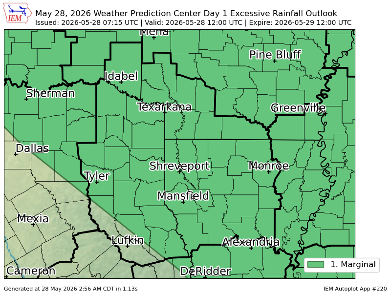
#WPC_MD 0260 affecting portions of southern, central, eastern Oklahoma, far north Texas, and far western Arkansas, #arwx#txwx#okwx, https://t.co/OQgun7fr6I
#WPC issues MPD 260 concerning HEAVY RAINFALL...FLASH FLOODING POSSIBLE: PORTIONS OF SOUTHERN, CENTRAL, EASTERN OKLAHOMA, FAR NORTH TEXAS, AND FAR WESTERN ARKANSAS https://t.co/jUd9lkmNQf
#WPC issues MPD 260 concerning HEAVY RAINFALL...FLASH FLOODING POSSIBLE: PORTIONS OF SOUTHERN, CENTRAL, EASTERN OKLAHOMA, FAR NORTH TEXAS, AND FAR WESTERN ARKANSAS https://t.co/XVPYpzPyoE


![NWStulsa's tweet photo. [12:15 PM - 5/27/26] - Shower and thunderstorm chances will expand across eastern Oklahoma and northwest Arkansas today and tomorrow. Heavy rain and dangerous lightning are expected along with locally gusty winds. #okwx #arwx https://t.co/RQ4MG1kj0V](https://pbs.twimg.com/media/HJV5FVTWYAIE3TL.jpg)


![iembot_fwd's tweet photo. A strong thunderstorm will impact portions of northeastern Hopkins County through 200 PM CDT [wind: 40 MPH, hail: 0.25 IN] https://t.co/8rIEqytvC1 https://t.co/5La1gkAWM2](https://pbs.twimg.com/media/HJbSyy3W4Ac_PIj.jpg)

![iembot_fwd's tweet photo. FWD issues Flood Warning for Fannin, Grayson [TX] till May 27, 5:00 PM CDT https://t.co/j8niG5B6Zf https://t.co/gjAAb80lpa](https://pbs.twimg.com/media/HJWRsbGWwAQ4UVe.png)

![iembot_fwd's tweet photo. At 10:15 AM CDT, 2 SSW Forney [Kaufman Co, TX] Emergency Mngr reports Flash Flood. Emergency Manager reported water on the roads in Melody Ln and Pecan Ln south of Forney. Water was reaching some of the homes. #txwx https://t.co/2VIBB5AwbU https://t.co/unCQf706IK](https://pbs.twimg.com/media/HJVxZsKXoAMXbPR.jpg)
![iembot_fwd's tweet photo. At 11:48 AM CDT, 1 E Sachse [Dallas Co, TX] Emergency Mngr reports Flash Flood. Emergency Manager reported road closure of Sachse Rd at Country Club Rd due to high water. #txwx https://t.co/b7OUWk8Dpq https://t.co/wKo6r1wIw1](https://pbs.twimg.com/media/HJV2o4UWwAcb7_9.jpg)
![iembot_fwd's tweet photo. At 11:15 AM CDT, 4 S Trenton [Fannin Co, TX] Postal Employee reports Flash Flood. Public reported Water on roads near state highway 78 and 160 just west of Leonard. #txwx https://t.co/zOcA3pyY3w https://t.co/SMrf1vrdAi](https://pbs.twimg.com/media/HJVyQ6gXoAAz8IP.jpg)
![iembot_fwd's tweet photo. At 11:00 AM CDT, 2 S Heath [Rockwall Co, TX] Local Official reports Flash Flood. Public official reported in social media road closure of Governors Blvd between FM 740 and Trophy Club Dr. There are also some impassable areas on Zurek Ln in the... #txwx https://t.co/dAUu5vi39M https://t.co/K4NdplloEy](https://pbs.twimg.com/media/HJV0SCqWYAMMOcW.jpg)