BREAKING: HUGE WILDFIRE IN LABRADOR, PANGASINAN 🔥
WILDFIRE ALERT: A huge wild grass fire hits a mountainous area of Brgy. Laois, Labrador, Pangasinan this Thursday evening, March 27, 2025.
STATUS UPDATES:
• WILDFIRE IN PROGRESS
#FireAlert#WildFire#Labrador#Pangasinan
HIGHEST FORECASTED HEAT INDEX TODAY
March 27, 2025, Thursday
WEATHER UPDATE: 67 weather stations sa bansa ang inaasahang makakaranas ng mainit at maalinsangang panahon ngayong araw, Huwebes, Marso 27, 2025.
#WeatherAlert#HeatIndex
HEAT INDEX UPDATE (FORECAST): 19 lugar sa bansa ang makakaranas ng MATAAS na HEAT INDEX o MARARAMDAMANG INIT na aabot sa NEAR DANGER (EXTREME CAUTION) HANGGANG DANGER LEVEL ngayong araw, Huwebes, Marso 27, 2025, kabilang na dito ang #MetroManila.
#WeatherAlert#HeatIndex
SUNOG SA UST HOSPITAL, SAMPALOC, MANILA CITY 🔥
FIRE ALERT: Fire hits inside the University of Santo Tomas (UST) Hospital, Sampaloc, Manila City, Metro Manila today, July 02, 2024. Firefighters are now on scene to extinguish the fire.
#FireAlert#HospitalFire#ManilaCity
An intensification into Tropical Storm is possible prior landfall. The highest possible Tropical Cyclone Wind Signal that will be raised for this tropical cyclone will be TCWS No. 2.
WEATHER ALERT: The Low Pressure Area spotted at Southeast of Mindanao outside the Philippine Area of Responsibility (PAR) develops into a minor Tropical Depression today , according to Japan Meteorological Agency (JMA).
#WeatherAlert#TropicalDepression#KabayanPH
PRE-KABAYAN is forecasts to move generally west northwestward and will make its first landfall over Northern Mindanao-Eastern Visayas area and will cross the Visayas archipelago starting Sunday evening until it emerges over the West Philippine Sea by Monday evening.
It is expected to become a full-blown Tropical Depression and enter PAR within the next 24 hours. Once it enters PAR, it will be locally named "KABAYAN" by PAGASA.
BREAKING NEWS: A Lite Ferry 3 ship capsized tonight in the vicinity of Ormoc City Pier, Leyte. The authorities are now on scene. More details to follow. I 📸: Ynah-Mira Bauya Danao
#MaritimeAlert#CapsizedShip#OrmocCity#Leyte
TYPHOON "KIKO" (CHANTHU) UPDATE
As of 11:00 PM, 09 September 2021, Thursday
KIKO maintains its strength while moving West Northwestward over the Philippine Sea East of Northern Aurora towards Extreme Northern Luzon
#WeatherAlert#Typhoon#KikoPH#Chanthu
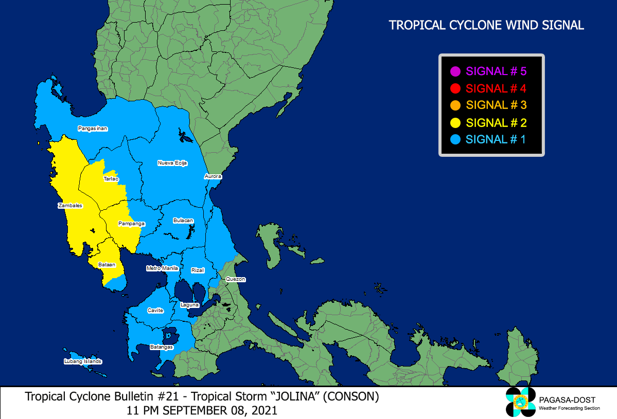
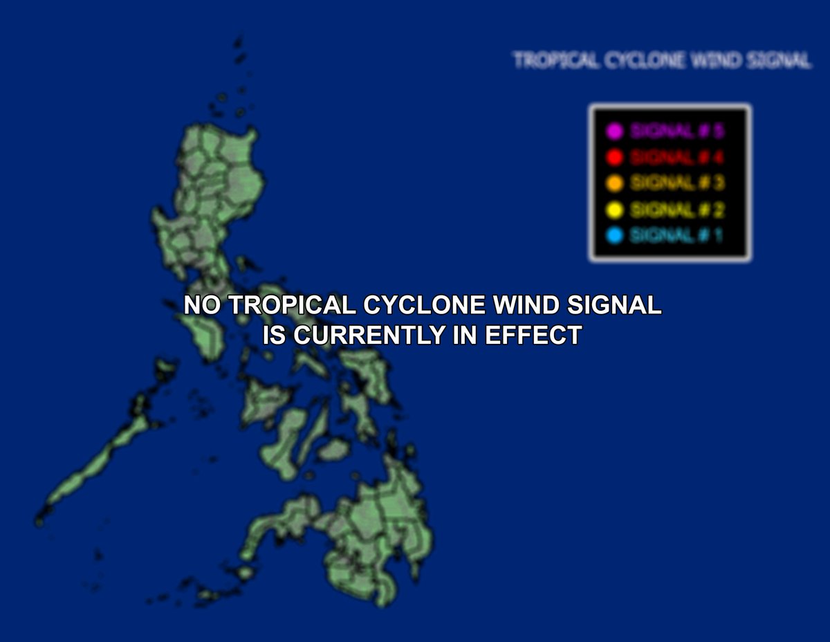
TROPICAL STORM "JOLINA" (CONSON) UPDATE
As of 11:00 AM, 09 September 2021, Thursday
JOLINA continues to move westward over the West Philippine Sea. Tropical Cyclone Wind Signals are now LIFTED.
#WeatherAlert#TropicalStorm#JolinaPH
TYPHOON "KIKO" (CHANTHU) UPDATE
As of 11:00 AM, 09 September 2021, Thursday
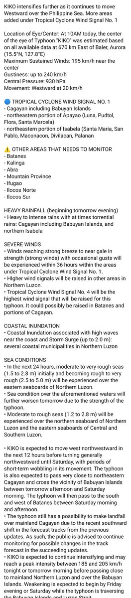
KIKO intensifies further as it continues to move Westward over the Philippine Sea. More areas added under Tropical Cyclone Wind Signal No. 1
#WeatherAlert#Typhoon#KikoPH#Chanthu
TYPHOON "KIKO" (CHANTHU) UPDATE
As of 5:00 AM, 09 September 2021, Thursday
KIKO resumes its intensification over the Philippine Sea East of Central Luzon
#WeatherAlert#Typhoon#KikoPH#Chanthu
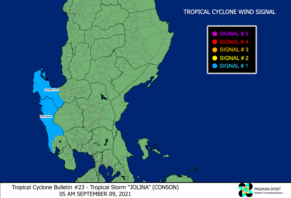
TROPICAL STORM "JOLINA" (CONSON) UPDATE
As of 5:00 AM, 09 September 2021, Thursday
JOLINA continues to move Northwestward away from Luzon landmass
#WeatherAlert#TropicalStorm#JolinaPH
BREAKING NEWS: TCWS No. 1 has been raised over the following areas in Cagayan Valley due to Typhoon "KIKO". 30-60 km/h winds are expected within 36 hours.
- eastern portion of Cagayan
- northeastern portion of Isabela
#WeatherAlert#Typhoon#KikoPH
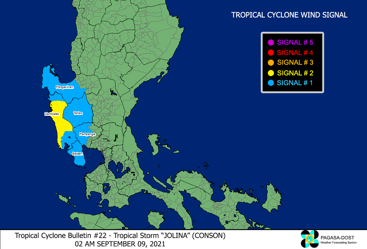
TROPICAL STORM "JOLINA" (CONSON) UPDATE
As of 2:00 AM, 09 September 2021, Thursday
JOLINA continues to move Northwestward away from Zambales.
#WeatherAlert#TropicalStorm#JolinaPH
TYPHOON "KIKO" (CHANTHU) UPDATE
As of 11:00 PM, 08 September 2021, Wednesday
KIKO maintains its strength while moving Westward over the Philippine Sea
#WeatherAlert#TropicalStorm#KikoPH#Chanthu
TROPICAL STORM "JOLINA" (CONSON) UPDATE
As of 11:00 PM, 08 September 2021, Wednesday
JOLINA is now over the coastal waters of Zambales Province.
#WeatherAlert#TropicalStorm#JolinaPH