Science communicator | MS Meteorology UP Diliman | JABYU just always bring your umbrella☂️ | Resident Meteorologist @abscbnnews @tvpatrol Ligtas Dapat @radyo630
I am deeply proud and grateful that Catanduanes achieved zero casualty during #PepitoPH—a testament to the resilience, preparedness, and unity of Catandunganons.
Knowing that my weather updates on TV Patrol and Facebook played a part in this is incredibly humbling and inspiring.
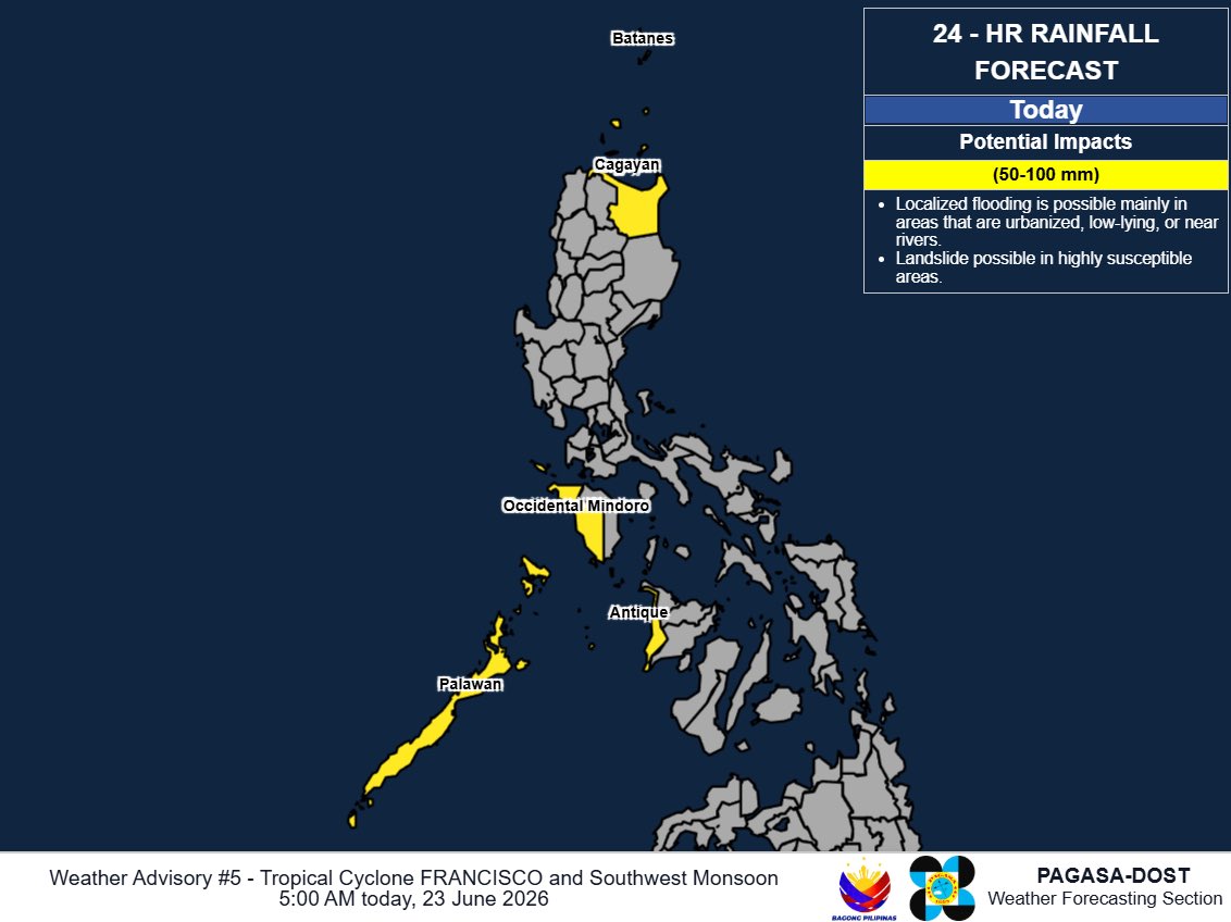
Moderate to heavy rains may be experienced due to Francisco’s outer rain bands and the Habagat:
• Batanes and Cagayan through Thursday
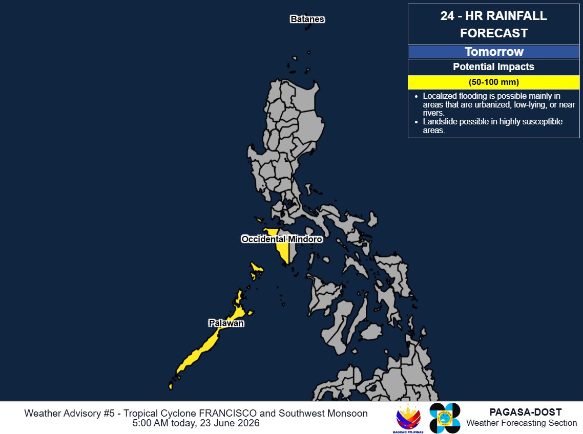
• Antique, Palawan, Occidental Mindoro, and Bataan through Friday
Flooding and landslides are likely, especially in hazard-prone areas.
Wind signal no. 1 is hoisted over Batanes and northeastern Cagayan.
Francisco is seen to gradually weaken as it recurves east of the Batanes-Babuyan area until its PAR exit late Thursday, June 25, or early Friday, June 26.
BAGYO UPDATE #FranciscoPH
11AM, June 23, 2026
Francisco weakens into a typhoon.
At 10 a.m. Tuesday, it was located 380 km east of Calayan, Cagayan.
It has sustained winds of 175 kph and gustiness up to 215 kph and is moving northwestward at 10 kph.
Flooding and landslides are expected in hazard-prones areas, especially during periods of prolonged and heavy rainfall.
Francisco may exit the Philippine area of responsibility on Friday, June 26.
BAGYO UPDATE #FranciscoPH
5AM, June 23, 2026
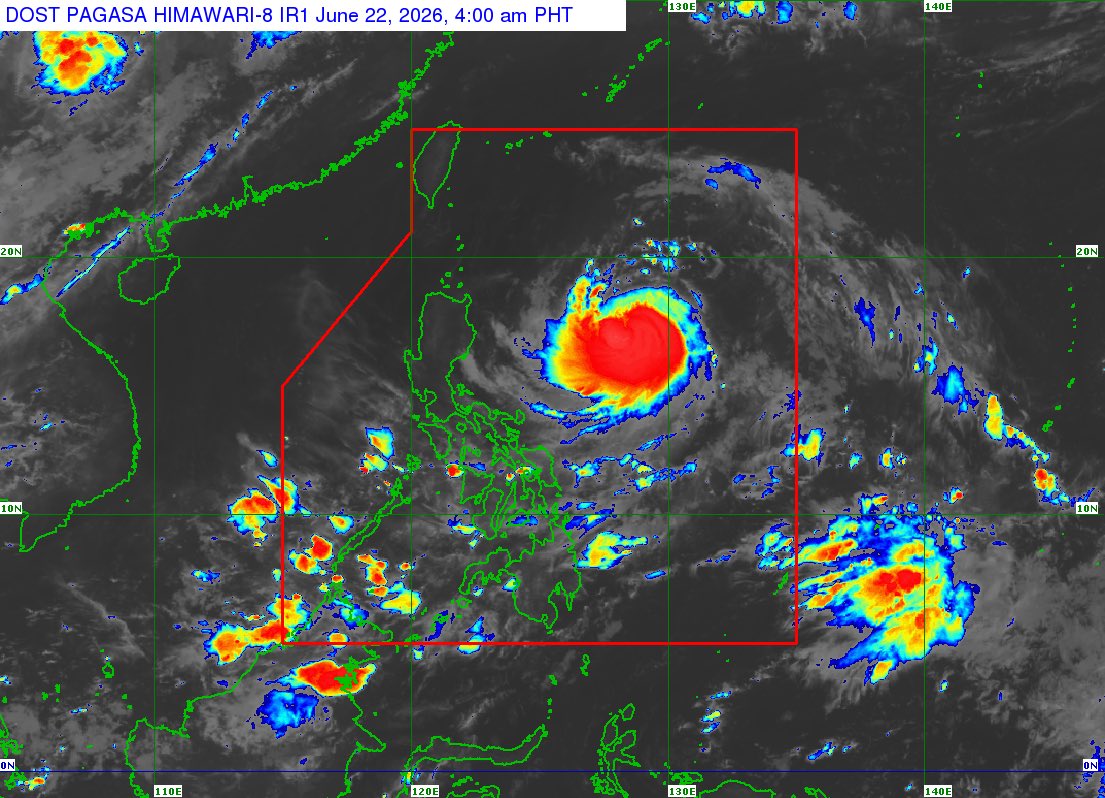
At 4 a.m. Tuesday, super typhoon Francisco was located 410 km east of Aparri, Cagayan.
It maintained its sustained winds of 185 kph and gustiness up to 230 kph. It is moving west northwestward at 10 kph.
This Tuesday, moderate to heavy rains rains may be experienced in Batanes and Cagayan due to Francisco’s rain bands and in Occidental Mindoro, Palawan, and Antique due to Habagat.
Moderate to heavy rains may persist in Batanes, Occidental Mindoro, and Palawan through Thursday.
Wind signal no. 1 remains in effect over Batanes and northeastern Cagayan.
Francisco may intensify further to 195 kph before recurving east of the Batanes-Babuyan area on Tuesday.
It may exit the Philippine area of responsibility on Friday, June 26.
BAGYO UPDATE #FranciscoPH
11 PM, June 22, 2026
Francisco intensified into a super typhoon, now packing winds of 185 kph with gustiness up to 230 kph.
At 10 p.m., it was located 450 km east of Aparri, Cagayan. It is moving west northwestward at 15 kph.
JUST IN: Francisco intensified into a super typhoon at 8 p.m. Monday, according to @dost_pagasa. It now packs winds of 185 kph with gustiness up to 230 kph.
Meanwhile, the low pressure area outside the PAR alsodeveloped into a tropical depression.
Weather Forecast for June 23, 2026, Tuesday
Magiging super typhoon na ang bagyong #FranciscoPH.
Mararamdaman ang masungit na panahon sa ilang lugar sa Cagayan Valley.
Magpapaulan naman ang Habagat sa western parts ng Visayas at Mindanao.
JABYU☔️
Francisco will reach super typhoon intensity on Tuesday at the onset of its recurvature near the Batanes-Babuyan area.
Wind signal no. 1 remains in effect in Batanes and northeastern Cagayan.
Signal no. 2 may be the highest possible wind warning that will be raised.
BAGYO UPDATE #FranciscoPH
5 AM, June 22, 2026
Typhoon Francisco is nearing super typhoon strength, with winds of 175 kph and gustiness up to 215 kph.
At 4 p.m., it was located 525 km east of Tiguegarao City, Cagayan. It is moving west northwestward at 20 kph.
BAGYO UPDATE #FranciscoPH
11AM, June 22, 2026
Typhoon Francisco has rapidly intensified.
At 10 a.m., it was located 620 km east of Tiguegarao City, Cagayan. It packs winds of 155 kph with gusts up to 190 kph and is moving west northwestward at 15 kph.
The typhoon will bring strong winds and moderate to heavy rains in Cagayan and Batanes through Thursday noon.
It will also enhance the southwest monsoon which will bring rains over the western part of the country.
Flooding and landslides are expected.
Flooding and landslides are likely during periods of prolonged and heavy rainfall.
Francisco may exit the Philippine area of responsibility by Friday, June 26.
BAGYO UPDATE #FranciscoPH
5AM, June 22, 2026
Wind signal no. 1 up in 2 areas as Typhoon Francisco intensifies further
At 4 a.m., it was located 715 km east of Tiguegarao City, Cagayan. It packs winds of 140 kph with gusts up to 170 kph and is moving west northwestward at 30 kph
Francisco’s rain bands will bring moderate to heavy rainfall in Batanes and Cagayan on Tuesday and Wednesday.
It will also enhance the southwest monsoon, with heavy rains expected over the western portions of Luzon, Visayas, and Mindanao.