The hot & humid weather will continue for the rest of the working week, with the heat peaking on Thursday🥵
There'll be some showers & thunderstorms from later Thursday.
Turning cooler & more changeable this weekend: rain on Saturday, then sunshine & scattered showers on Sunday
⛈️ Sodeč po radarskih odbojnostih so močnejše padavine trenutno verjetne predvsem v Posočju, padavinski pas pa se pomika proti vzhodu.
⛈️ V naslednjih dveh do treh urah še pričakujemo nevihte z nalivi, ki bodo potovale proti vzhodu. Nato se bo ozračje postopno umirilo.
A warm and generally dry weekend ahead
A mix of cloud & sunshine on Saturday⛅️ with highs of 17 to 23 degrees
More widespread sunshine on Sunday☀️ with highs of 18 to 24 degrees.
Fog may encroach on some coastal fringes though making it cooler there😶🌫️
🌡️ Die Luftmassen in 850 hPa werden jetzt immer wärmer
📈 Von zuletzt teils nur 4 bis 7°C steigen die Werte bis zum Wochenende auf 10 bis 15°C
🔥 Das ist die Grundlage für verbreitet sommerliche bis heiße Temperaturen am Boden
Tomorrow will be a cool, breezy day with sunny spells and blustery showers, some of which will be heavy.☔️
Highs of 10 to 14 degrees with moderate to fresh and gusty northwesterly winds, strong near coasts.🍃
🔗https://t.co/sFyGizB5AS
Today will be cool & blustery with a mix of sunny spells and scattered showers, turning heavy at times 🌦️ 🍃
Highs of 10 to 14°C 🌡️
More ℹ️ https://t.co/itZWaoDj9A
Heute viele Schauer und teils kräftiger Regen, regional mit größeren Mengen
⛈️ Dazu immer wieder Gewitter mit Starkregen, Graupel und stürmischen Böen
❄️ In den Alpen oberhalb 1500 m Schnee, insgesamt nass, kühl und unbeständig
⛈ Močnejše nevihte se pojavljajo na zahodu države. V zadnji uri smo na meteorološki postaji Vedrijan izmerili 30 mm padavin. Padavine in nevihte se bodo v naslednjih urah širile v notranjost države.
🌦️ Heute in Deutschland wechselhaft: Norden teils trocken und aufgelockert, sonst viele Wolken mit Schauern und einzelnen Gewittern
🌧️ Besonders in der Mitte und im Süden immer wieder Regen, lokal auch kräftiger
🌡️ Temperaturen meist 12 bis 25°C – im Süden etwas wärmer
🌍 LUFTMASSEN-UPDATE (Instagram Post)
🌬️ Über Deutschland liegt eine geteilte Luftmassenstruktur:
⬛ Norden: eher feuchte, kühlere Luft unter hochnebelartigen Wolken → nur mäßig mild
☁️ häufig St/Sc-Wolken, kaum echte Durchmischung
☀️ Süden: deutlich trockener & wärmer
Rather dull today with occasional patches of light rain and drizzle
A few sunny breaks are possible🌦️
Highs of 11 to 14 C in light to moderate west to southwest winds🍃
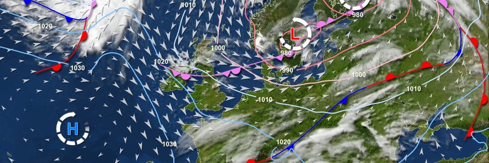
This super-smooth clouds and pressure animation is based on #DWD#ICON#weather forecast model data and shows the possible development in the next 18 hours. Graphics: https://t.co/VcWApIyc74
We have applied our super smooth #weather data interpolation technology to #DWD#ICON forecast model data and this is the result for the next about 3/4 day. Graphics: https://t.co/VcWApIyc74
Special data interpolation technology makes it possible to create super smooth cloud animations like this one for the next 18 hours based on #DWD#ICON data. Graphics: https://t.co/VcWApIyc74
This super-smooth clouds and pressure animation is based on #DWD#ICON#weather forecast model data and shows the possible development in the next 18 hours. Graphics: https://t.co/VcWApIyc74
Einen wunderschönen guten Morgen aus Offenbach. Nachdem es letzte Nacht vor allem im Osten und im Südwesten mitunter kräftig geschneit hat, schneit es derzeit vor allem in der Lausitz und am Alpenrand noch ein wenig. Aber auch sonst flockt es hier und da etwas. /V