Sunday was one of the stormiest days we've seen so far this year... Check out all the storm reports from yesterday & radar estimated rain totals over the last 24 hours⛈️.
#gawx#Savannah#weather
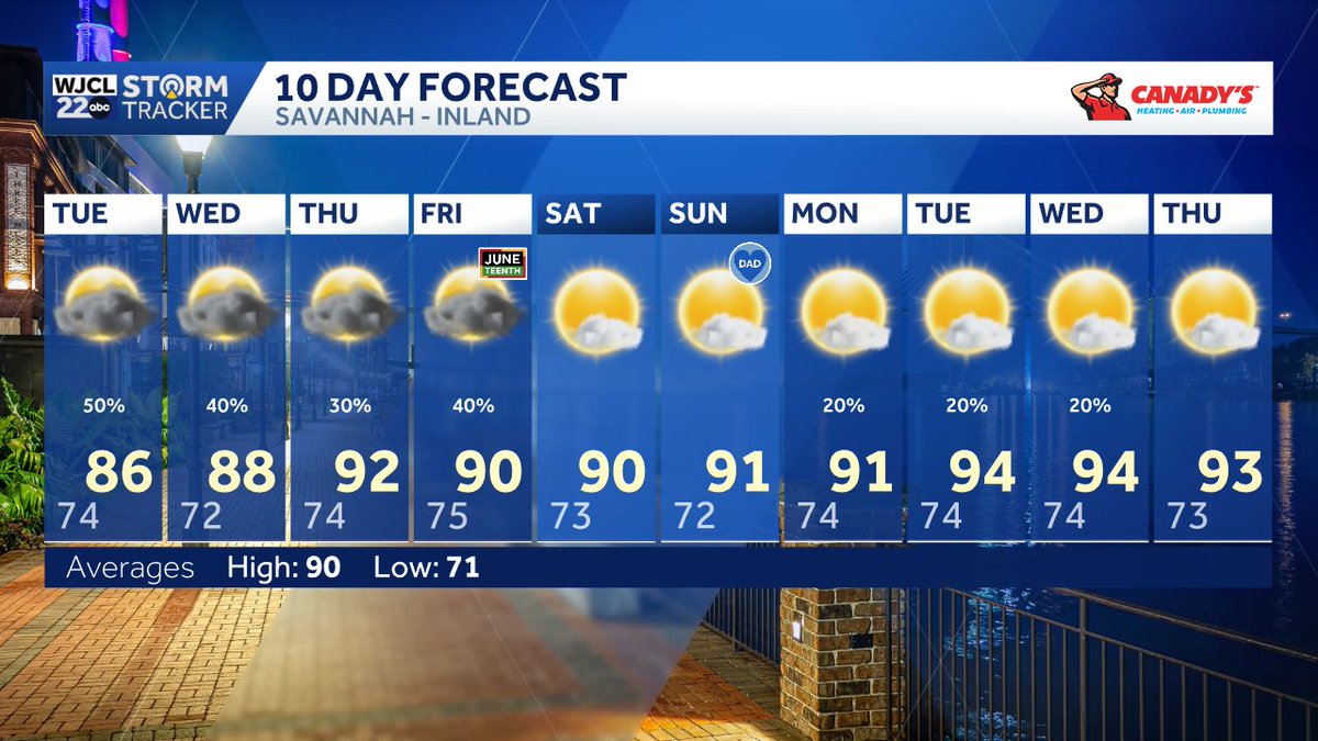
A cold front draped over the Southeast will stall out heading into Tuesday, keeping clouds & rain chances around throughout the day, but giving us a break from the heat☁️!
#gawx#Savannah#weather
Tropical Update: #Invest90L over NE Mexico now has a 50% chance of development over the next 7 days...
Models are continuing to show this system just barely re-emerging into the Gulf late Tuesday, where it may try to briefly develop into our first tropical storm of the season heading into Wednesday. Main concerns for the U.S. will be heavy rain and high flooding risks for portions of the Gulf Coast states.
#tropicswx #HurricaneSeason2026
Tropical Update: Still monitoring a broad area of low pressure located over eastern Mexico...
The system may re-emerge in the Gulf this week, bringing heavy rain to portions of Texas & Louisiana, but overall chance of tropical development is still low.
#tropicswx #HurricaneSeason2026
Tracking another line of strong-severe thunderstorms moving from west to east this evening⛈️.
Once this line clears out, that should wrap up any severe weather concerns for Southeast Georgia and the Lowcountry.
#gawx#Savannah#rain
SEVERE T-STORM WARNINGS for portions of Screven, Effingham, Hampton, Jasper, & Allendale counties until 4:30 PM & 5PM⚠️.
Possible Hazards: 60 mph wind gusts
SEVERE T-STORM WARNING for portions of Screven, Effingham, Hampton, Bulloch, & Allendale counties until 4:30 PM⚠️.
Possible Hazards: 60 mph wind gusts