Meteorologist and general nerd with a sense of humor. Loves weather forecasting and IT. I appreciate when people express themselves with facts over feelings.
Hurricane Milton presently a category 4 hurricane.......
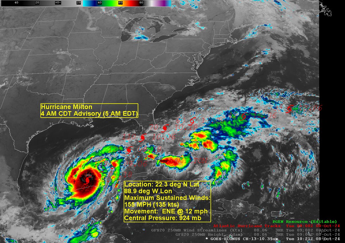
As of 5am EDT this morning Hurricane Milton was located at 22.3 deg N Latitude and 88.9 deg W Longitude which puts Milton 520 mi SW of Tampa, FL.
I am using the 5am advisory due to the fact that the track graphic that is overlayed on the satellite images attached to this post corresponds to the 5am EDT (4am CDT) advisory. The 11 AM EDT advisory does not have a track forecast available in my version of AWIPS so I wanted to make sure that everything matched up from a temporal point of view. I will include any graphic that the NHC posted at 11am in this post.
Ok, disclaimer complete.
Hurricane Milton is a very well defined, intense and dangerous storm. Fortunately, it is expending much of its wrath over schools of fish in the Gulf of Mexico and perhaps the occasional buoy. Milton was moving almost due east earlier but, as we moved into Tuesday morning the effects of an upper-level trough moving through the southern US has caused Milton to veer a bit north of due east and this turn should continue to execute as he interacts with northern latitude weather systems streaking along in the jet stream. In addition to turning Milton these interactions will start to introduce wind shear into his environment and that should start to weaken Milton as he approaches the FL coast.
The problem here is that Milton is such an intense storm, and it is moving at a decent clip that it won't have time to dissipate the storm's energy sufficiently to get Milton down to a manageable level (I'm sure FL would rather a Cat 1 over a Cat 3 or 4) so when Milton reaches the west coast of FL (very close to Tampa is the current model thinking) it will still be a strong, disruptive and, yes, dangerous storm to contend with.
Milton is forecast to slice right through central FL impacting from Tampa through the Orlando/Disney area exiting the state through the Space Coast. These are all areas that are going to be extremely sensitive to a high impact weather event such as this. I would anticipate evacuations and closures of major attractions to start happening by tomorrow afternoon at the latest. In fact, evacuations along the west coast of FL in and around the Tampa area should start now. Hurricane warnings are already flying along much of the central western coast of FL and also the eastern and northeastern coast, centered around Cape Canaveral, of Florida as well. Remember winds will still be above hurricane force as the center of Milton tracks completely through the state.
Storm surge will be a serious threat with this storm around the Tampa area as 10-15 foot storm surge is expected from Anclote River, FL southward along the coast to Englewood, FL. Given the shape of Tampa Bay inundation can happen very rapidly and can result in loss of life and property if you are caught unaware.
It is imperative that local evacuation orders be heeded right away. 6-10 foot storm surge values exist both north to Yankeetown, FL and south to Bonita Beach outside of the 10-15 foot surge area.
Given the strong winds currently churning within Milton, maximum sustained winds in Milton at landfall could be at or above 100 knots or 115 mph which would put Milton at the low end of Category 3 on the Saffir-Simpson Hurricane intensity scale. Don't let the description "low end" mislead you however. A category 3 hurricane whether and the top of the scale or near the low end is still considered to be a major hurricane and must be taken seriously. Wind damage will be significant along the west coast of FL penetrating well in land as the storm's sustained winds only drop to between 96-110 mph (Cat 2) and these winds can do significant damage to life and property.
The models are pretty clustered around Milton arriving at the west coast of FL between 3-6am Thursday morning. Intensity forecasts are all over the map with some models rapidly weakening Milton before reaching the coast and others holding together the hurricane around 100kt right around landfall. Since the most reliable of the Hurricane models goes with this I concur with the NHC intensity forecast as presented in their advisory packages. Looks like a Cat 3 storm will impact the Tampa area.
The big question is where exactly, relative to Tampa, does Milton make landfall? If Milton makes landfall north of Tampa that will represent the greatest threat to the Tampa metro area since S-SW winds at Cat 2-3 speeds will drive the water northward right up into the Bay and widespread and destructive flooding will result. If Milton tracks south of Tampa then the winds will be more N to NE and that will push the water out of the Bay and limit the scope of the disaster (but not entirely eliminate it). We should all hope for the latter solution or even better a complete miss.
Well, that's the update. If you have interests in the Tampa area all the way to the Central Florida coast, I advise you to stay in touch with the weather forecasts in that area and take action when advised to do so.
#tropics #MiltonFlorida #miltonhurricane #MILTON
@AH_Status The free AWIPS server is often not timely and often glitches. The fact that there is little interest doesn't make it a reasonable and attractive option for AllisonHouse to offer but more notice would have been appreciated.
Southern New England Forecast - Becoming less humid with quiet weather as we end the work week and move into the weekend. #MAwx#CTwx#RIwx https://t.co/jpxl5faoh3
Southern New England Forecast - A muggy day today with a risk of thunderstorms, cooler and drier weather returns for Friday and the weekend. #MAwx#CTwx#RIwx https://t.co/hTyw70h8sR
Southern New England Forecast - Getting a little more sticky today then much more humid tomorrow with the risk of a few boomers. #MAwx#CTwx#RIwx https://t.co/HmlXjWUs15