Mature line of thunderstorms is nearing West Michigan's doorstep, which'll sweep through over the coming hours (6 PM - 9 PM). Damaging wind (60+ MPH) the main concern.
Severe Thunderstorm Watch likely on the way shortly.
3:50 PM UPDATE: A line of strong to severe thunderstorms is moving through southern Wisconsin and northern Illinois, and is expected to reach the lakeshore around 6 PM before sweeping east through West Michigan this evening. Damaging winds of 60+ mph are the primary concern.
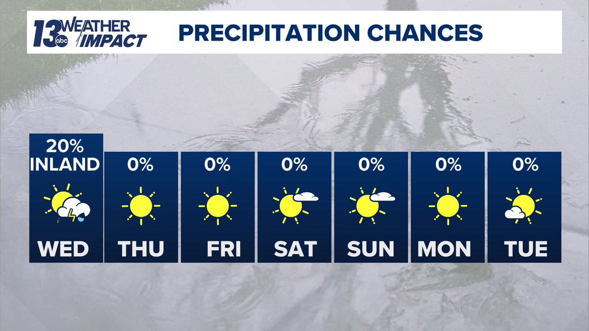
Weather Aware Wednesday & Thursday... multiple rounds of thunderstorms are possible, with some storms potentially reaching severe limits.
Damaging wind appears to be the primary concern, though all hazards may be on the table Thursday.
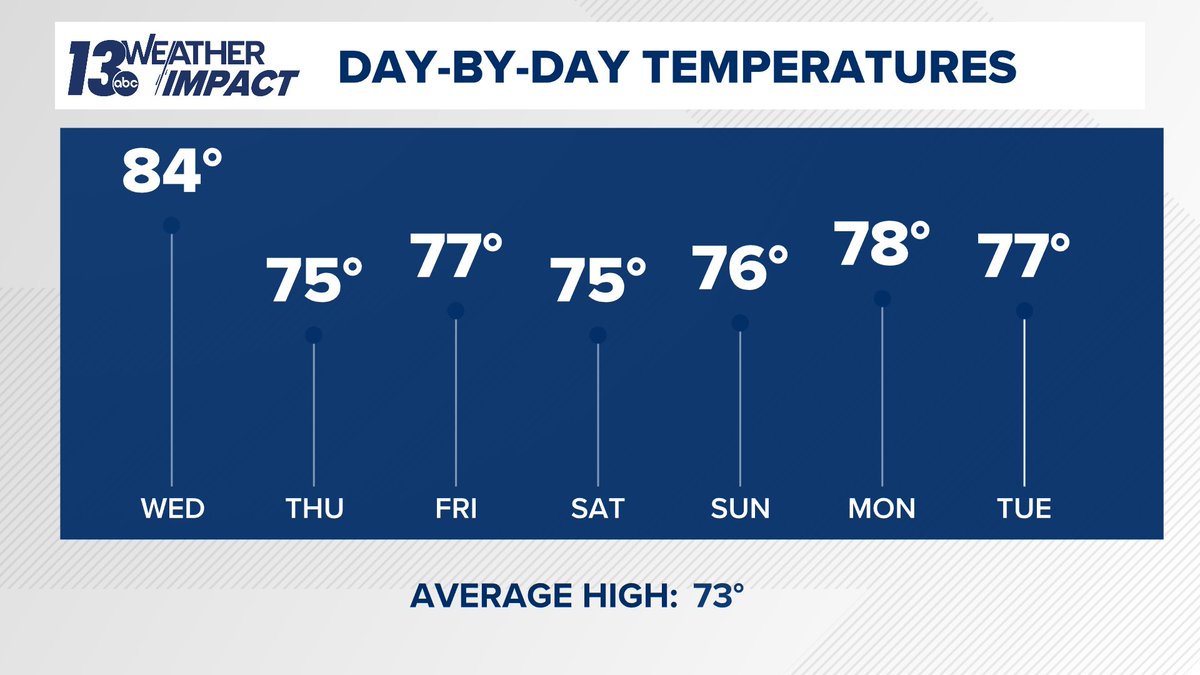
Air you can wear is here! Heat index values will surge into the 90s Wednesday and Thursday. ⛈️
Periodic thunderstorms are expected through the week, with the greatest severe weather risk Wednesday night & late Thursday. Damaging wind appears to be the primary concern
Next weeks focus... building heat and humidity, especially late in the week.
Ridging will reaffirm itself across the Great Lakes, which'll soar temperatures and a southerly flow will boost the humidity. It'll feel like a sauna!
Quiet Thursday, Unsettled Friday. Drier Saturday?
Incoming cold front will serve as the catalyst for showers/storms throughout Friday. There's been a trend for it to sweep through West Michigan earlier on Saturday, which would allow for more dry time than stormy weather.
🌟Fans of the night sky... take a look at Venus & Jupiter!
The two brightest planets in the evening sky are putting on a show much of June, appearing closer together each evening before reaching their closest alignment on June 9. Look west-northwest shortly after sunset!
It’ll be a broken record around here... tranquil skies will be the rule of thumb late week, this weekend, even into much of next week.
The only cloud cover of note will be some higher-level cirrus, primarily Friday into Saturday. Nothing that’ll interfere with outdoor plans!
Omega block pattern will influence our weather to round out May... and it'll be about as quiet as it can be.
The influence of the ridge of high pressure will promote ample sunshine and near average temperatures in the 70s.
Severe T-Storm Warning for Kent, Ottawa, Kalamazoo & Calhoun Co. until 3:30 PM. There remains an separate ongoing Severe T-Storm Warning for Allegan & Van Buren County.
Winds upwards of 60 to 70 mph the main risk with these thunderstorms, which are trekking northeast.
Severe T-Storm Warning for Allegan & Van Buren Co. until 2:15 PM.
Winds upwards of 60 mph the main risk with these thunderstorms, which are trekking northeast.