Attempting to gain knowledge in meteorology and monitor natural disasters and their damage. Hopefully Chasing Storms, and also chasing a career in Meteorology.
@JackPeltz1 I recently got both subscriptions, and I will say that RadarScope is still superior in Radar quality, but WeatherFront has it beat in tons of things. Models, Satellites, ease of use, etc. If WeatherFront added a couple Radar based things, then it would be perfect.
We are watching what could be an active weather pattern developing around this weekend and continuing to early next week. This is driven by our upper level ridging pattern that will break down, shifting the jet stream into the Great Lakes. Updates to follow.
Jaw-dropping satellite and radar imagery of Super Typhoon Bavi as it barrels toward the southern portion of the Mariana Islands, including Guam. Notice on radar the abundance of tornadic supercells in the western semicircle of the storm...this is quite unusual for a Northern Hemisphere tropical cyclone, as they're usually found in the eastern semicircle.
I was shooting storms in some prime jet conditions in Oklahoma, and almost got a gigantic jet right by me. This is one of those cloud-top features that could develop into a GJ with just a little more juice. Crazy and beautiful plasma
🌡️ Here are the latest Key Messages for the prolonged and dangerous heat wave that is set to impact the central and eastern U.S. through the week and into the weekend.
@Jayluke949@ibraheem_martin I have seen occasional instances of weather stations (mainly personal) tending to overdo dew points in specific areas. That’ll raise the heat indices easily.
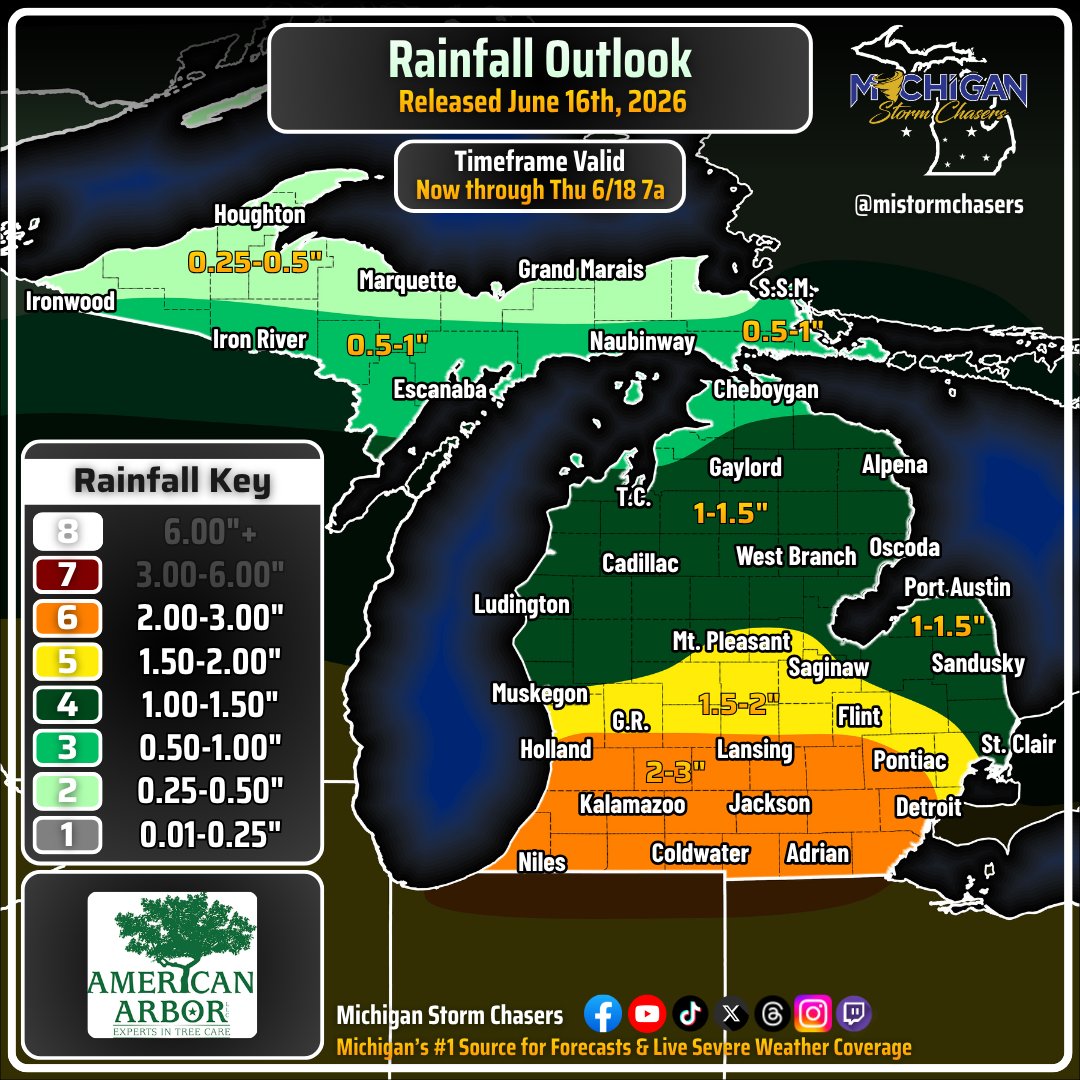
A chance for flash flooding exists across the Lower Peninsula, primarily starting on Wednesday, June 17th, 2026. Rainfall will also occur today, but most locations will see under 1".
Heavy rainfall within a low pressure system, aided by strong moisture advection from the south will allow for above average, perhaps daily records for rainfall rates across the I-96 and I-94 corridors. PWAT values over 2" at times will allow for continuous rain throughout the day, with supplemental dew points and temperatures in the 60s. 2-3", with localized pockets of 4" cannot be ruled out for all areas in the orange. This area may shift north depending on how far north the warm front can lift. All this rain will keep things stable, hindering most severe storm development, but not all. Heavy rain should be wrapping up by early Thursday morning, as denoted in the timeframe listed. The chances for flash flooding in the areas where 1.5"+ is expected are 15-30%.
-- Trusted Partner of the Day --
American Arbor | Call 269-244-8524 today for all your tree care needs across southwestern lower Michigan!
Violent tornado damage on the outskirts of Kouts, Indiana from last nights tornado. The high tension powerlines toppled and crumbled into pieces are especially eye popping! #INwx