@USASteeplechase I grew up watching these legends ❤️
Bill Shoemaker
Pat Day
Laffit Pincay, Jr
But, Julie Krone - She made me want to become a jockey 🥰😎
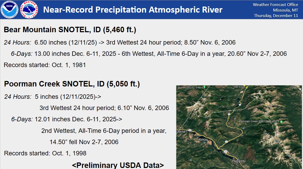
🌧️An Atmospheric River dumped 5 to 6.50 inches of rain in the last 24 hours (ending 12/11/2025) in western Lincoln & east Boundary Counties-ranking it the 3rd Wettest 24-Hour Period in 44 years at Bear Mountain SNOTEL. Since Sat. Dec 6, 12-13 inches of water equivalent has fallen
❄️Changes arrive this weekend! Prepare for slick travel over the passes with cold and windy conditions in the backcountry. Some light snow potential in the valleys by Sunday night/Monday. #idwx#mtwx
Weekly weather outlook for W MT & NC ID:
🌨️ Mon: Mountain snow tapers off.
☀️ Tue-Fri: Warming & drying trend.
🌫️ Caveat: Fog could limit warming.
❄️ Next Wknd: Growing chances for mountain snow.
Watch our full recorded briefing for details! https://t.co/3rVuiDCMIs #mtwx#idwx
🌬️ Strong and damaging NE winds are forecast for NW Montana Sun night into Mon.
📍 Primary concern: Flathead Valley and SE #FlatheadLake.
💨 Gusts: 40-50 mph.
⚠️ Threats: Falling trees/branches, potential power outages, and Flathead Lake dock damage.
❄️ Snow is on the ground in the high country this morning (especially in Glacier NP).
• Forecast: Showers linger this AM, then decrease.
• Temps: 30s in the mountains, 40s/50s in the valleys.
⚠️ Heading into the backcountry? It's winter up there. Pack accordingly. #mtwx
Widespread frost/freeze hitting the Northern Rockies Monday & Tuesday!
Time to harvest those last vegetables and get your home, property, and vehicles ready for winter. Remember, impacts will vary by location, so check the latest forecast at https://t.co/KjpLweDamj. #mtwx#idwx
ICYMI: A taste of winter is on the way! Prepare for cold, wind, and snow. Backcountry roads could become slushy and hypothermia is a real risk. Pack extra layers and be safe!
Headed to the high country this weekend? A taste of winter is on the way! Prepare for cold, wind, and snow. Backcountry roads could become slushy and hypothermia is a real risk. Pack extra layers and be safe! #MTwx#IDwx
Thunderstorms are expected in NC ID and west-central/SW MT by this evening. Expect heavy rain (up to 0.75 in/hr, watch for debris flows!), lightning, and gusty winds (40-50 mph). These conditions could impact outdoor plans #mtwx#idwx
7:45PM: Rainfall rates are decreasing across El Paso. However, flooding is currently ongoing across downtown/central El Paso. Image below was taken from @txdotelp camera at I-10 and Piedras. #txwx