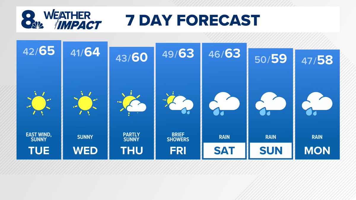
Sunny skies and cool temperatures in the 60s are in our future for the next few days. Expect breezy conditions Tuesday afternoon. Overnight lows will be cold, triggering a Frost Advisory for some areas like Hillsboro and Vancouver, and a Frost Warning in the Gorge. #kgwweather
Expect showers in Portland to return early Saturday afternoon, and last through sunset. Then, there will be brief break in the rain until Sunday morning, when rain will return once more, and last through the night. Temperatures will rest in the 50s all weekend long. #kgwweather
Expect Friday to start with showers. By noon, we will get a brief break, mainly dealing with cloudy conditions. However by evening and then into Saturday morning, we will see the rain return, which will last through the weekend. Expect snowfall in the mountains. #kgwweather
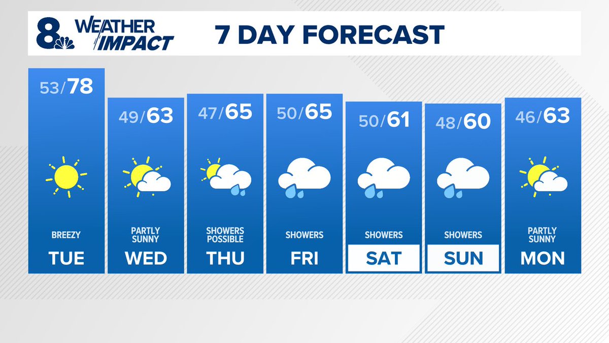
The warm weather continues for one more day, as Tuesday is expected to bring the upper 70s. Expect breezy conditions in the morning. The potential for showers arrives Thursday, with the real potential for rain arriving Friday, and lasting through the weekend. #kgwweather
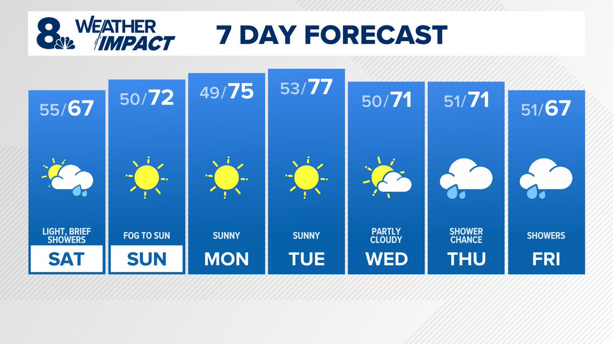
Expect light, scattered showers Saturday, especially in the morning and early afternoon. The good news is that rain totals will be less than .10", and by Saturday evening conditions will improve. Sunday will be a sunny day, with temperatures reaching the low 70s. #kgwweather
The weekend starts warm and sunny, before widespread rain rolls in late Saturday night, bringing light showers on Sunday. The good news is this wraps up by Sunday night, and Monday, the clouds clear and we will return to mild and warm temperatures. #kgwweather
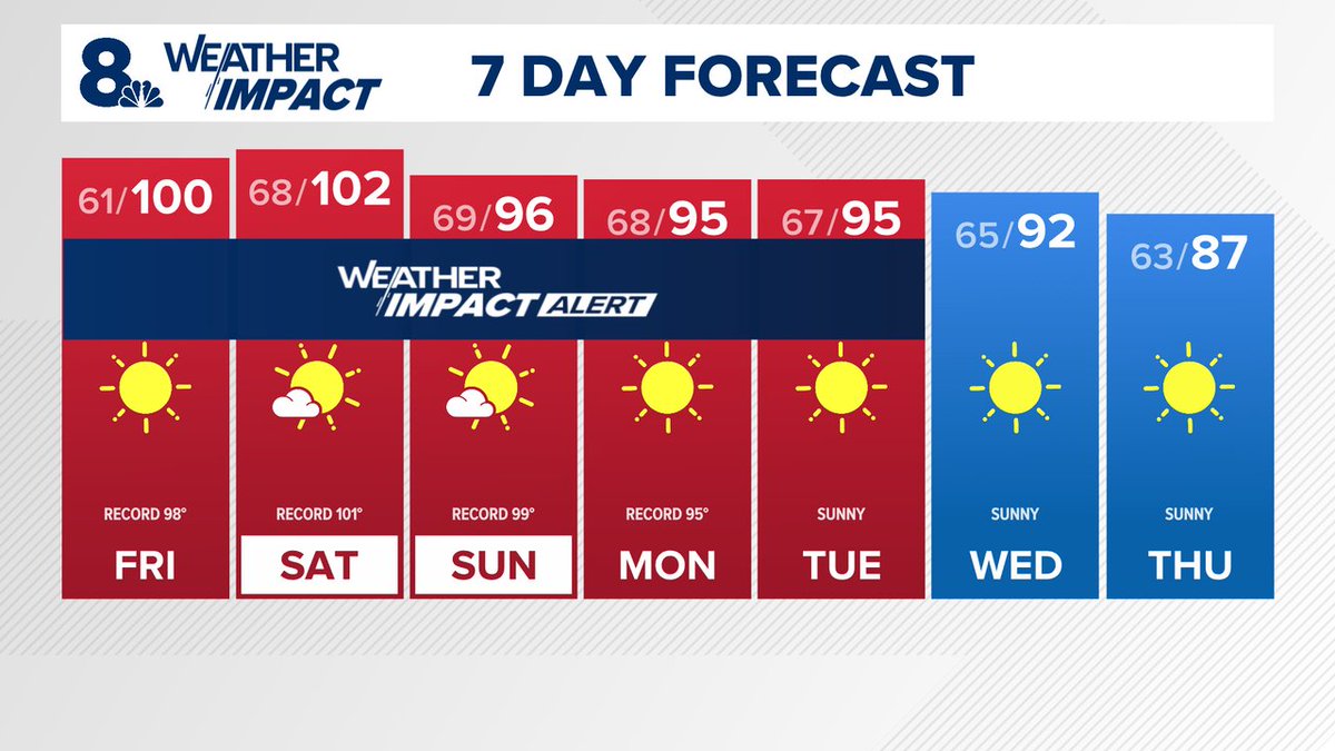
We are looking at extreme heat coming to many parts of Oregon, including Portland. We're under an Excessive Heat Warning, as temperatures are set to break records and enter the triple digits on Friday and Saturday. Overall, expect the heat to stay until next Thursday. #kgwweather
We are entering a warming trend, with Friday set to be the hottest day this week. An Extreme Heat Watch has been issued starting Friday for parts of Portland and the Gorge, as well as the Hood River Valley, with the heat lasting through the weekend. #kgwweather
Although widespread rain is moving into the area, the majority of the rainfall we are set to see will fall overnight. By tomorrow morning, we will start to dry up, and the only additional rain we should see will be in the form of brief showers that end by evening. #kgwweather
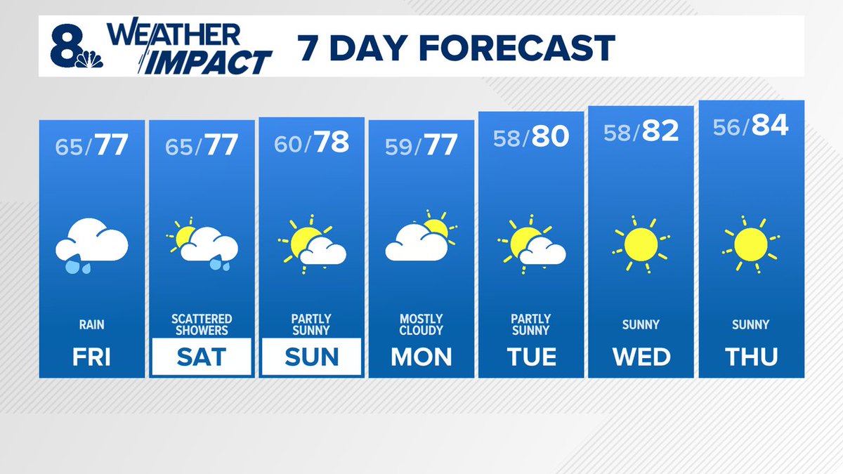
After a hot week, we are now waiting for the rain to move in overnight in the form of scattered showers, before the heavier, steady rain rolls in by Friday afternoon. Temperatures will remain in the upper 70s, but expect a cloudy and wet day. #kgwweather
Expect the weekend to continue to be mild, although Sunday is expected to be slightly cooler than today, with much more cloud coverage. However, by late afternoon, those clouds will begin to clear. The 80s return Tuesday, yet we may also see some showers by night. #kgwweather
Expect a seasonable and warm weekend ahead. Temperatures will remain in the upper 70s and low 80s all weekend, and the next small heat up comes on Tuesday, when the 90s return for a couple of days, before we return to the 80s by Thursday. #kgwweather
A Red Flag Warning is in effect tonight for the Eastern Columbia River Gorge, due to critical fire weather conditions. As for the Portland area, a more mild weekend is in store, with temperatures peaking in the low 80s to upper 70s, with some clouds to go with it. #kgwweather
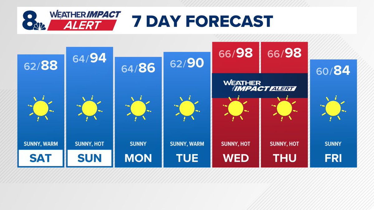
We continue to see highs in the upper 80s tomorrow, and then mid 90s Sunday. A Heat Advisory is in effect Sunday due to the heat, and we've issued a KGW Weather Impact Alert for next Wednesday and Thursday, due to temperatures reaching the upper 90s. #kgwweather
The holiday weekend will continue to improve once we arrive at Saturday, when temperatures are expected to rise into the upper 70s, and sunny conditions return. The warm up continues into early next week, as we hit the 80s Sunday and 90s by Tuesday. #kgwweather
This weekend marks the start of a warming trend, with sunny conditions returning by Saturday afternoon and temperatures jumping into the upper 80s by Sunday. Expect low 90s on Monday, and a warm week ahead as temperatures remain above average through the 4th of July. #kgwweather
Temperatures start warming up Friday into the low 70s, although the clouds linger for one more day until we transition into a warm, sunny and dry weekend. Expect temperatures to increase to the upper 80s by Sunday, with a solid chance of breaking the 90° mark by Monday.
This weekend will truly feel like spring, with temperatures in the mid to upper 70s all weekend long. Expect more cloud coverage tomorrow compared to today. The good news is we should be staying dry. After that, we're looking at a warm and dry week. #kgwweather
Expect today's temperatures to peak in the low to mid 70s. The day will be partly sunny, with increased clouds rolling in by evening. Memorial Day is shaping up to be mild temperature wise, but expect brief, scattered showers that end by late afternoon. #kgwweather
This holiday weekend will be warm and mild, with temperatures Saturday in the upper 70s with clear skies. However, Memorial Day brings light showers throughout the day with low 70s for highs. The good news is the rain is expected to be light and clears up by evening. #kgwweather