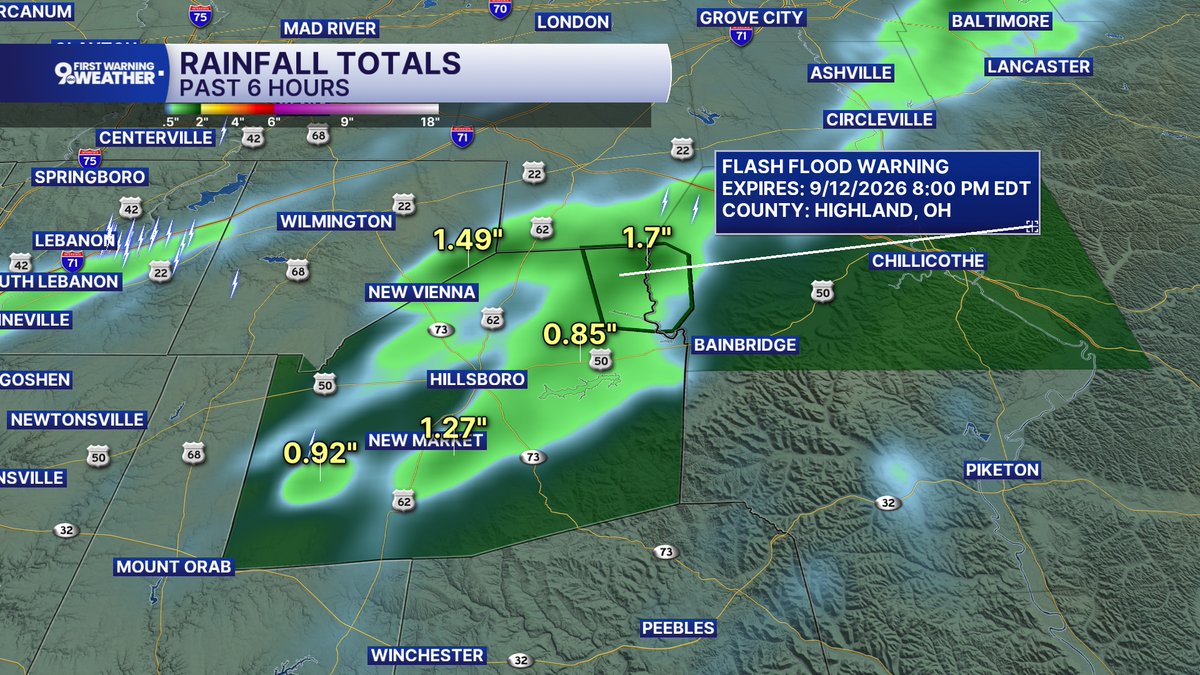
9 FIRST WARNING: A Flash Flood Warning is in effect until 8pm Saturday for the northeast corner of Highland County, where rain totals are nearing 2 inches.
If you come across a flooded road, Turn Around, Don't Drown. Keep kids away from high water.
9 First Warning: Flood Watch until Midnight for Highland, Brown, Adams, Bracken, Mason, and Robertson counties. After heavy rain the ground is saturated and more rain is coming into Saturday #wcpo
🐅🛍️Today find bargains, Bengals gear, and help support young adults struggling with mental health issues. Please stop by and take a peak! 👀
Plus, our famous @TonyDaTiger96 will be debuting his brand new booblehead, signing autographs, & creating special shopping moments!
9 First Warning: Flood Advisory for Campbell & Clermont counties until 1:45am. 2"-3" of rain has already fallen and another 1"-2" is possible Minor flooding is ongoing or expected #weatheraware
9 First Warning: Flood Advisory is out for Hamilton County until 1:15am. Up to 2.5" of rainfall has already fallen and an additional 2" is possible. Minor flooding is on going or expected. #weatheraware
NEW: A flash flood warning has been issued for northern Adams County until 8:30 a.m. 1.5-3" of rain has fallen in the area. Flash flooding is ongoing or is expected to begin shortly. #wcpo#cincywx
A flash flood warning is in effect for Highland County until 7 a.m. 2-5" of rain has fallen in the area and another 1-2" of rain is possible. #wcpo#cincywx
As dawn brightens Wednesday morning the 9th, use binoculars to help pick up the thin waning crescent Moon low in the east-northeast about a fist-width below Jupiter. Look 4° or 5° below the Moon for twinkly Regulus.
https://t.co/qYJ0DSMzoQ
#stargazing
9 FIRST WARNING: A Severe Storm Warning is in effect until 9:45pm Saturday for Switzerland, Boone, Gallatin, Owen, and Grant counties. Damaging 60mph winds are possible along with small hail, heavy rain, and lightning as the storm moves SE at 25mph. Stay indoors!
9 FIRST WARNING: A Severe Storm Warning is in effect until 9pm Saturday for parts of Boone, Kenton, Campbell, Grant, and Pendleton counties. Damaging 60mph winds are possible along with small hail, heavy rain, and lightning as the storm moves SE at 25mph. Stay indoors!
9 FIRST WARNING: A strong storm is moving southeast through Greater Cincinnati around 25mph with heavy rain, lightning, 50mph wind, and half inch size hail. The storm likely reaches downtown between 7:45 and 8pm Saturday.
9 FIRST WARNING: The Severe Storm Warning for Robertson and Mason counties has been canceled as of 5:15pm Saturday, but strong storms with heavy rain, lightning, hail, and strong wind continue to move southeast through northern Kentucky. Stay indoors until these clear your city.
9 First Warning; Severe T-Storm Warning for Northion Portion of Butler County & Franklin Co Winds to 60mph, frequent lightning, torrential rain. Check the graphic for times. #wcpo
9 First Warning: Severe T-Storm Warnings for Butler, Warren & Clinton Counties Wind gusts to 60mph, torrential rain and frequent lightning Check the graphic for times #wcpo