Hey everyone! In case you haven't seen, WF put new signage on the top of 550 S Tryon and won't be doing lighting tributes until they complete the building's lighting updates next year.
I'll still post updates when other buildings' lights have meaning - just will be less frequent
Hey everyone! In case you haven't seen, WF put new signage on the top of 550 S Tryon and won't be doing lighting tributes until they complete the building's lighting updates next year.
I'll still post updates when other buildings' lights have meaning - just will be less frequent
The Charlotte skyline is red tonight ❤️ for Valentine's Day. You've got less than an hour. Get off this thing off & go be with your person (happy you’re sharing the moment here first, but seriously, go!)
The Charlotte skyline is lit up for the @Hornets again tonight! It's purple and teal 🟪🟦 to support them as they attempt to start a new win streak starting with the @ATLHawks
The Charlotte skyline is multiple colors tonight! The BofA buildings are teal and purple 🟦🟪 for the @hornets 7th win in a row today ‼️ and the Truist building is red and green 🟥🟩 for the start of Black History Month
🚨 URGENT WEATHER ALERT: THIS IS THE REAL DEAL 🚨
Folks, I cannot stress this enough: Please prepare now!
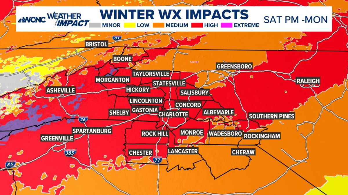
We have all day today (Friday) and most of the daylight hours on Saturday to get ready. After that, the window closes. This is not a "bread and milk" situation—this is a major to extreme ice threat. We are looking at a setup we haven't seen in at least 10 years, and if the higher ice totals hold, we could be looking at something we haven't dealt with in 20 years (think back to the 2002 ice storm).
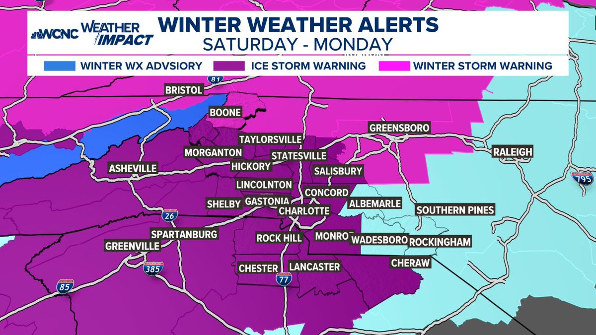
Here is the reality of what is coming this weekend (Sat PM - Monday):
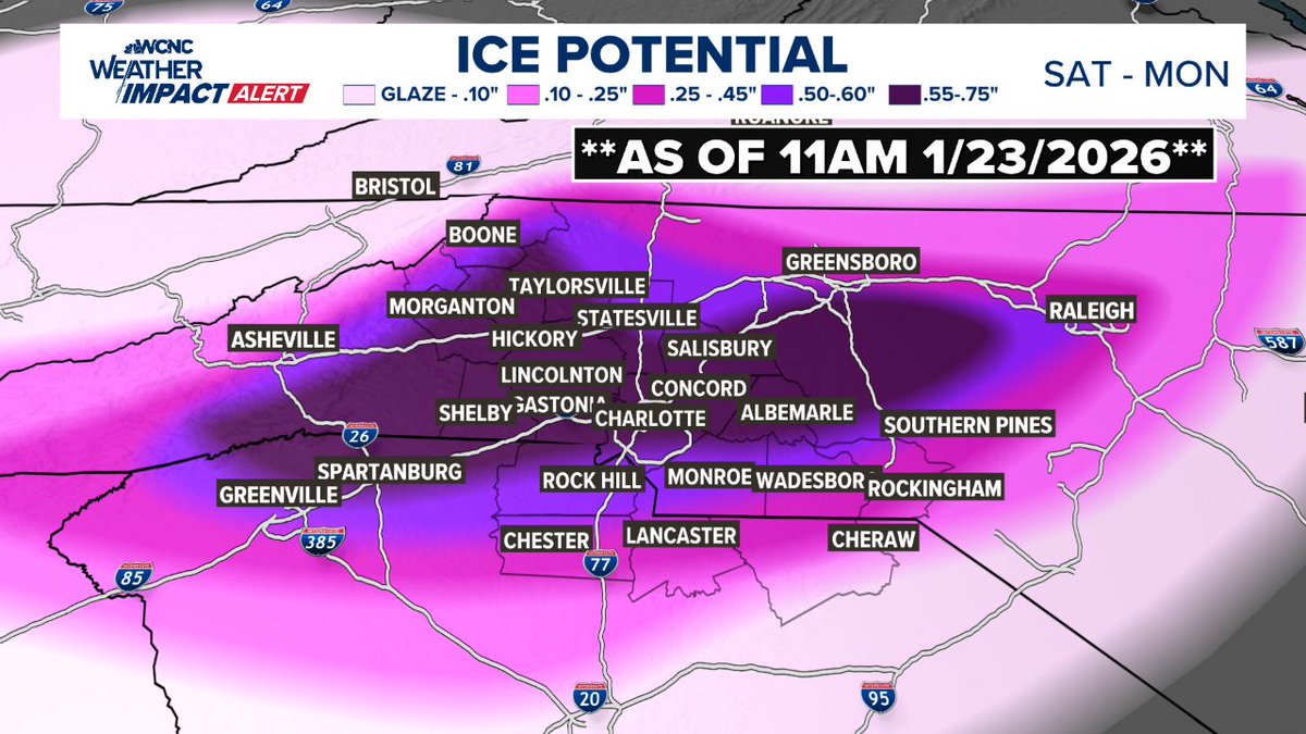
🧊 THE ICE THREAT
Look at the maps attached. That pink and purple area isn't just "snow." It is freezing rain and heavy ice accumulation.
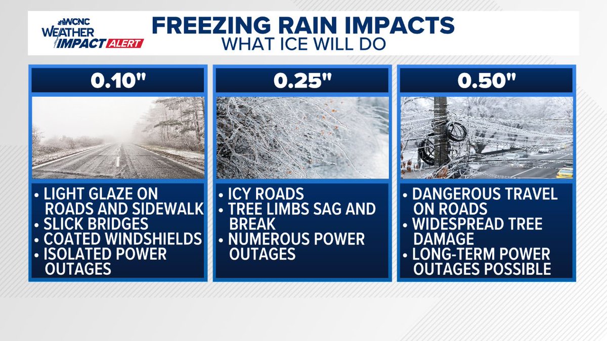
The forecast shows potential for 0.25" to 0.75" of ice.
What that means: At 0.25", tree limbs snap and power lines go down. At 0.50"+ (which is possible in the darker purple bands), we are talking about widespread, long-duration power outages and impassable roads.
🛑 IMPACTS: WHAT TO EXPECT
POWER OUTAGES: This is my biggest concern. With ice accumulating on trees and lines, outages are likely. If you are in the high-risk zones, you need to be prepared to be without power for days, not hours.
TRAVEL: By Saturday night, travel will likely become dangerous to impossible. Do not plan to be on the roads Sunday. If you get stuck in an ice storm, emergency crews may not be able to reach you quickly.
TREES: The weight of the ice will bring down weak limbs and trees. If you have large trees over your driveway or home, be hyper-aware.
⏳ YOUR ACTION PLAN (DO THIS NOW):
You have until Saturday evening to get this done. Do not wait.
1. CHARGE EVERYTHING: Phones, laptops, tablets, and power banks. Do it now while the grid is 100%.
2. HEAT: If the power goes out, how will you stay warm? Have blankets ready. If you have a fireplace, get wood. **NEVER** use a generator or grill indoors—carbon monoxide is a silent killer.
3. FOOD/WATER: You don't need to panic buy, but have enough food that doesn't require cooking (sandwiches, dry goods) and water for 72 hours.
4. MEDICAL: If you need prescriptions or oxygen, secure it today.
The Bottom Line:
This isn't a "fun snow day." This is a damaging ice event. We have been lucky for a long time, but the data is showing a setup that demands respect and preparation.
Use today and tomorrow to prepare your family and check on your elderly neighbors, then stay off the roads once this starts.
Stay safe, stay warm, and stay tuned for updates.
#cltwx #ncwx #scwx #wcnc #iceOMG #icestorm #wxbrad