We’re rethinking participatory planning with tools that go beyond public meetings.
In Project Claiborne Reborn, we’re using:
🗺 GIS + air quality overlays
💬 Map-based feedback
🌡 Sensor data
The goal: deeper, more grounded community engagement.
We’re exploring new ways to make community engagement more interactive and accessible.
For Project Claiborne Reborn in New Orleans, we built a tool that combines real-time air quality data, GIS overlays, and map-based feedback from residents.
🔽 Demo video:
📣 Announcing Project Claiborne Reborn
We're partnering with @LSUHealthNO & Claiborne Avenue Alliance on an EPA-funded initiative empowering New Orleans’ Treme neighborhood through citizen science, interactive maps, and community-driven tech.
#UrbanTech#NewOrleans 🧵👇
Goals of #ProjectClaiborneReborn:
✅ Equip students & residents to measure air quality
✅ Use GIS & interactive maps for community planning
✅ Provide free sensors & educational tools
✅ Advocate for environmental awareness & community health
#GIS#CommunityEngagement
@the_transit_guy Thanks Hayden, but this brilliant work was done by @JoshAFrank and his team at @DoverKohl. We were responsible for developing the public website at https://t.co/0lcVbegTRM
Collective Form is thrilled to announce our @Wharton Innovation Fund Implementation Award!
We are incredibly grateful to The Wharton School @vntrlab for recognizing our potential and investing in Collective Form’s future.
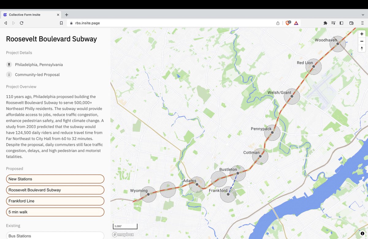
Check out our @ColForm Insite page on the Roosevelt Boulevard Subway!
We just added more data on the 5 min walk radius of stations on the proposed subway. We will add more data in the coming weeks.
Let me know what data you want to see on the page!
https://t.co/mNt5UKvhLc
We've created an interactive map to showcase the proposed Roosevelt Boulevard Subway line with new stations and the extension of the Market-Frankford Line.
Check it out would love to hear your feedback! Thank you @ColForm
https://t.co/mNt5UKvhLc
Cities account for 78% of global energy consumption and are responsible for 60% of global greenhouse gas emissions. Transportation and the built environment (including buildings and the systems used to manage internal climates) are the worst offenders.
https://t.co/xOEyrLa57q
We’re developing a new, interactive community engagement platform for urban design and planning projects.
If you’re working on a planning or mobility study, sign up for Insite Early Access to be among the first to use Insite.
Stay tuned🔔 https://t.co/Lj5D3A6bWQ