HURRICANE SEASON STARTS JUNE 1: State leaders urge resident to stay aware and prepare for summer storms. @LGSusanB@CTDEMHS More here: https://t.co/1tMr34d27n
He has a lifetime of experience in service as an EMT, a U.S. Army veteran and a police officer. He will bring all of that experience to his new role with the Bristol Fire Department. https://t.co/psWiExyoFd
Whether they're police, fire rescue, tow truck drivers, construction workers or other first responders, they're there to do a job and get home safe. Let 's help them do that. Slow Down and Move Over. #CTDOT#SlowDown#MoveOver
The FEMA Review Council approved its final report today. Public comments are open until June 8, 2026. All Council documents are available at: https://t.co/cosH6IliME
More info: https://t.co/WJ8jogmamQ
🚨URGENT NEWS!🚨
The NFFF is pleased to announce that the U.S. DHS has confirmed the campus of the United States Fire Administration will be open for the 2026 National Fallen Firefighters Memorial Weekend, scheduled for May 2–3 in Emmitsburg, Maryland.
https://t.co/9mCrH8oIQk
We've got another Traffic Incident Management class coming up on April 11! In this class we teach first responders about responder safety, clearance, and prompt communications. Register for an upcoming class: https://t.co/dxO9nPk99o #TrafficIncidentManagement
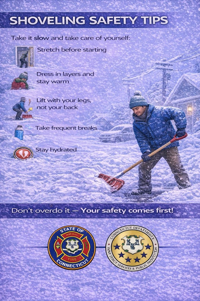
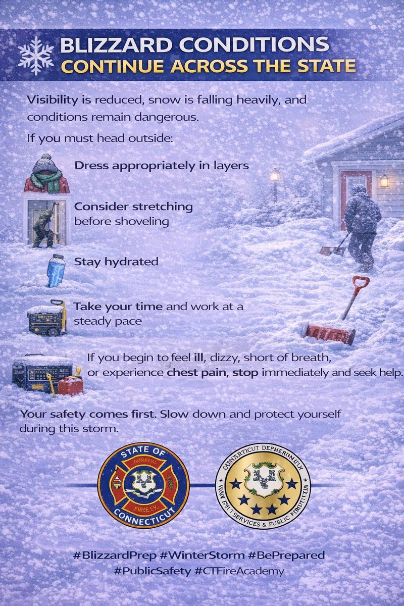
Shoveling Safety Reminder
As you venture out to start or finish the clean up, make your safety the priority
Snow removal is hard work and can put serious strain on your body. Each year, we see injuries and cardiac events during cleanup.
@CTDESPP@CTDEMHS
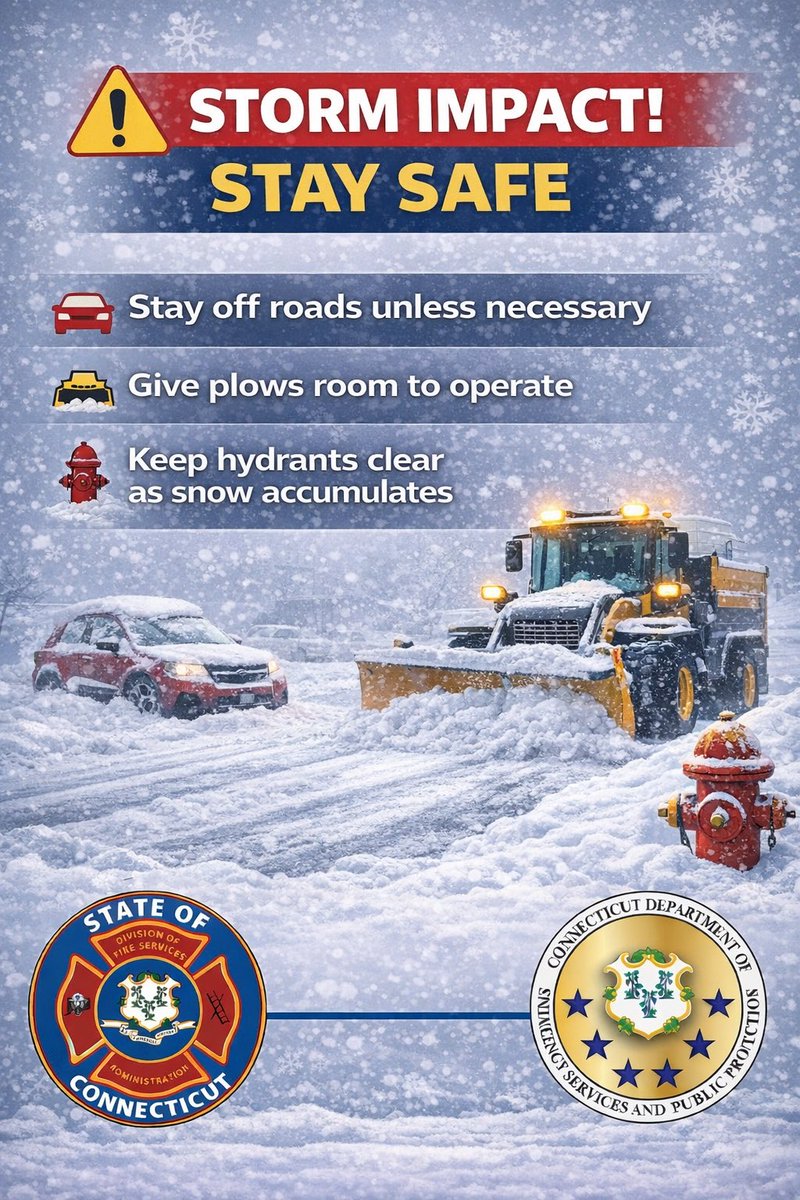
We’re facing a blizzard tonight into Monday. Strong winds. Whiteout conditions. Do NOT travel. If you HAVE to drive, be safe, put the distractions away, and DON’T CROWD THE PLOW.
Register with https://t.co/JSNq5SdTSy for real-time travel reports and live traffic cameras. #CTDOT
[Potentially Historic/Destructive Storm southeast of the BOS-PVD corridor] We are very concerned for areas southeast of the Boston-Providence corridor where wet snow combines with northeast wind gusts of 60-70 mph. Power outages & tree damage. Worst conditions Mon 4 am to noon.
[3/3] Strong-damaging winds accompany the storm. Strongest winds further east (gusts up to 60 mph, potentially up to 70 mph) early Mon morning-Mon evening. ⚠️This combined with heavy wet snow will increase risk for tree damage and power outages, especially east MA/RI🌲.
[2/3] ❄️Steadier snow arrives Sun evening through late Sunday night. Heavier snow rates (1-2"/hr) arrive after 2 AM Mon continuing through Mon afternoon. Snow decreases later Monday afternoon, exiting Monday night. ⚠️Hazardous travel conditions likely.
[1/3]❄️High-impact winter storm expected to hit southern New England Sun evening-Mon night bringing strong winds and heavy snow. Blizzard conditions likely in east MA & RI. Hazardous travel expected. Increased risk for tree damage/power outages in east MA/RI. #MAwx#RIwx#CTwx
Connecticut officials warn of increased house fire risk during extreme cold. The cold is dangerous in several ways, and the increased fire risk is among them.
https://t.co/rIYwRY8Shu
@CTDESPP@CTDEMHS@GovNedLamont


![NWSBoston's tweet photo. [2/3] ❄️Steadier snow arrives Sun evening through late Sunday night. Heavier snow rates (1-2"/hr) arrive after 2 AM Mon continuing through Mon afternoon. Snow decreases later Monday afternoon, exiting Monday night. ⚠️Hazardous travel conditions likely. https://t.co/5QiuknQaSG](https://pbs.twimg.com/media/HBtWa4xWUAAm09E.jpg)
![NWSBoston's tweet photo. [2/3] ❄️Steadier snow arrives Sun evening through late Sunday night. Heavier snow rates (1-2"/hr) arrive after 2 AM Mon continuing through Mon afternoon. Snow decreases later Monday afternoon, exiting Monday night. ⚠️Hazardous travel conditions likely. https://t.co/5QiuknQaSG](https://pbs.twimg.com/media/HBtWPaVXAAANynt.jpg)
![NWSBoston's tweet photo. [1/3]❄️High-impact winter storm expected to hit southern New England Sun evening-Mon night bringing strong winds and heavy snow. Blizzard conditions likely in east MA & RI. Hazardous travel expected. Increased risk for tree damage/power outages in east MA/RI. #MAwx #RIwx #CTwx https://t.co/3Wp3Ydgc3E](https://pbs.twimg.com/media/HBtTZjOWkAA4V7n.jpg)
![NWSBoston's tweet photo. [1/3]❄️High-impact winter storm expected to hit southern New England Sun evening-Mon night bringing strong winds and heavy snow. Blizzard conditions likely in east MA & RI. Hazardous travel expected. Increased risk for tree damage/power outages in east MA/RI. #MAwx #RIwx #CTwx https://t.co/3Wp3Ydgc3E](https://pbs.twimg.com/media/HBtS7AKWYAAjgGB.jpg)


![NWSBoston's tweet photo. [Potentially Historic/Destructive Storm southeast of the BOS-PVD corridor] We are very concerned for areas southeast of the Boston-Providence corridor where wet snow combines with northeast wind gusts of 60-70 mph. Power outages & tree damage. Worst conditions Mon 4 am to noon. https://t.co/8NHt3mkDIP](https://pbs.twimg.com/media/HBxN0EMXkAA_q-c.jpg)
![NWSBoston's tweet photo. [3/3] Strong-damaging winds accompany the storm. Strongest winds further east (gusts up to 60 mph, potentially up to 70 mph) early Mon morning-Mon evening. ⚠️This combined with heavy wet snow will increase risk for tree damage and power outages, especially east MA/RI🌲. https://t.co/oNqQz8iaaF](https://pbs.twimg.com/media/HBtYIi_XcAAJ3GT.jpg)
![NWSBoston's tweet photo. [2/3] ❄️Steadier snow arrives Sun evening through late Sunday night. Heavier snow rates (1-2"/hr) arrive after 2 AM Mon continuing through Mon afternoon. Snow decreases later Monday afternoon, exiting Monday night. ⚠️Hazardous travel conditions likely. https://t.co/5QiuknQaSG](https://pbs.twimg.com/media/HBtaYC2WIAAGvQA.jpg)