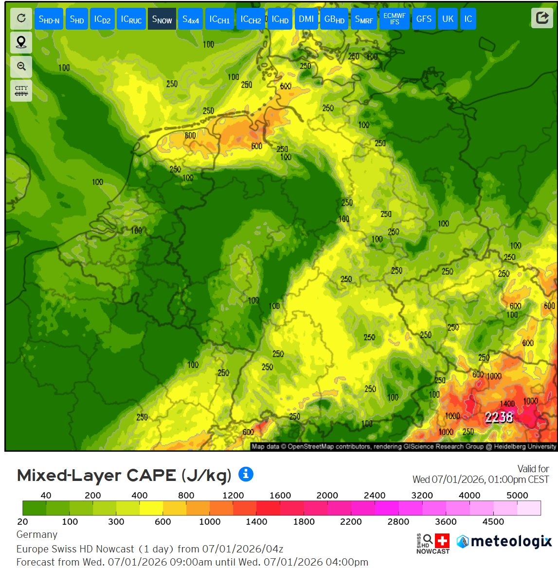
As central Europe is facing severe weather with high CAPE values, North Germany and surrounding also can expect some storms. Shear is on the weak side, however some rotating cells can still happen due to higher 0-3 CAPE and local storm interactions.
Pretty long timelapse of the progression of the storms forming in West Germany on the 26th of June. Towards the middle the first updrafts start to form from blue sky.
This evening very strong storms formed over the Netherlands, they contained hail, gusts, downpours and a lot of lightning. These continue to be a threat while they move NE.
In the south a MCS is making its way NNE. Currently, severe wind gusts are ongoing with this.
As convection is still ongoing in the west (slowly dying/moving off over the sea) new surface based convection is popping around the boundary of 2 air masses colliding.
Also note the thunderstorms forming towards Denmark.
As heat is peaking across central Europe, we got cumulus fields forming.
Some cells are expected to form in the marked area more south, then less certain are the cumulus in the more NE marked region. These are less certain to pop and will be more local.
If the cells form, they pose a threat for lightning, wind gusts and isolated flooding due to very slow movement.
It is likely that this will not be widespread due to lower temperatures creating for a strong cap and forcing lacking.
On Friday, temperatures could reach very high around the Benelux, with values just below, and if not, 40 degrees.
Due to this heat, the convective temperature may be reached, this then could be enough to trigger some isolated thunderstorms.
Semi-Isolated convection occurred throughout south Germany. This cell more to the west was able to use a bit of the available shear and become a left moving supercell.
Hodograph indeed does support for potential left movers with radar having indicated hail, currently it is dying.
A bow echo formed in the SW storm, this already has been producing strong wind gusts for a while now and will continue to do so.
In the meantime, more storms are forming SE of it on its outflow.
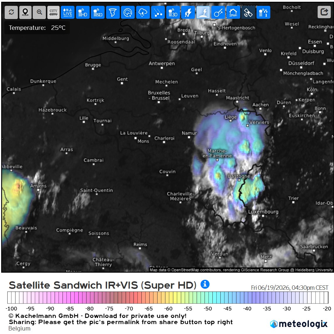
Two main regions of convections around the Benelux.
Some more (elevated) cells seem to form in the Netherlands.
It is also possible that more cells erupt east of the complex in the (south) west.
More (stronger) cells are popping around East Belgium, this system moves NNE.
In the meantime the boundary from the west is creating for strong cells in NW France.
Observed soundings from 12 UTC show that the convective temp has not been reached at places of sounding launch.
Yet, elevated cells are situated in N-France within the greatest risk area.
The sounding shows these likely form from the 700 hPa layer.
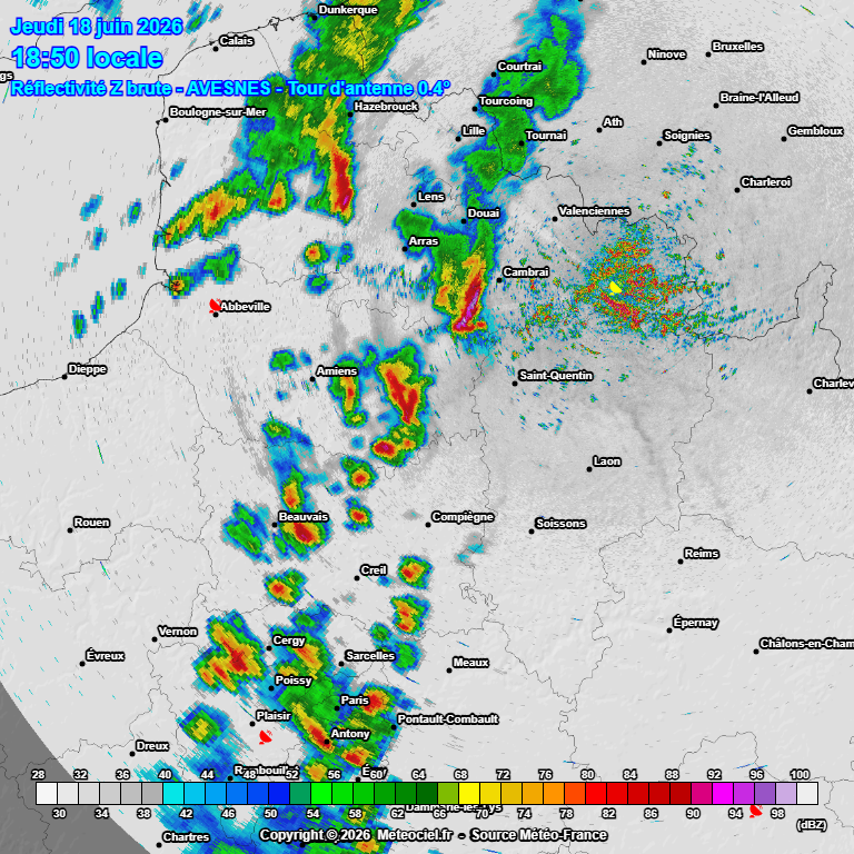
Currently some thunderstorms and supercells active in NW France. These move NE as the day progresses.
Intensity may increase with these or other cells before decreasing slowly later in the evening.
Of course, some cells may vanish earlier.
The details are still very vague, but it seems that this system is able to survive until the evening and maybe going into the night where convection will go elevated.
Risks are hail mainly during the day and besides that, wind gusts, lightning and heavy rain.
[1/2] Thursday, a region of spin in the air caused by convection in Spain on Wednesday will makes its way through the Bay of Biscay into NW France.
This is likely to create enough lift to make use of the cape that is available.


![Finntie2's tweet photo. [1/2] Thursday, a region of spin in the air caused by convection in Spain on Wednesday will makes its way through the Bay of Biscay into NW France.
This is likely to create enough lift to make use of the cape that is available. https://t.co/Zd663vGqmd](https://pbs.twimg.com/media/HLAnNPdW0AA9aAt.jpg)
![Finntie2's tweet photo. [1/2] Thursday, a region of spin in the air caused by convection in Spain on Wednesday will makes its way through the Bay of Biscay into NW France.
This is likely to create enough lift to make use of the cape that is available. https://t.co/Zd663vGqmd](https://pbs.twimg.com/media/HLAnKCmW8AA2JR4.jpg)


![Finntie2's tweet photo. [1/2] Thursday, a region of spin in the air caused by convection in Spain on Wednesday will makes its way through the Bay of Biscay into NW France.
This is likely to create enough lift to make use of the cape that is available. https://t.co/Zd663vGqmd](https://pbs.twimg.com/media/HLAnTB6XMAA6mQy.jpg)


