Discover robust APIs and SDKs, analysis-ready geospatial datasets and tools, powerful cloud computing, and no-code geospatial evaluation and analysis tools.
Want a better app experience for your users? Get grounded with Google's trusted Maps data to transform LLM reasoning and customize AI responses with geospatial content.
🌍 https://t.co/7ZzVpXnadv
Building generative AI applications requires more than just logic — it requires real-world context. With Grounding with Google Maps and Maps Grounding Lite, you can access the next generation of geospatial intelligence and create conversational, location-based experiences via Gemini Enterprise Agent Platform, the Gemini API, Google AI Studio or MCP.
🛣️ Enhance AI responses with targeted recommendations and fresh information about places, routes and weather.
🏪 Provide nearby recos, answer queries and tailor responses by combining your data with info on 300M+ places worldwide.
⚡ Learn more about maps grounding and try it at the link above.
#GoogleMapsPlatform #GenerativeAI #Grounding #GeoAI #Developers
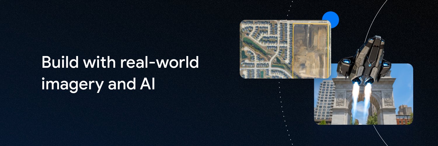
📷 ⚡ Want to create high-fidelity assets that have global-scale accuracy and are seamlessly integrated with your own subjects? Now you can with Maps Imagery Grounding (Private Preview) in Gemini Enterprise Agent Platform ➡️ https://t.co/JUUGfrcYi5
Now you can transform geospatial imagery into real-world visual experiences, with an authoritative foundation to ensure your AI-generated content is anchored in real locations.
Why this changes the game for businesses and creators:
✨ Unique Perspectives: Access vantage points and camera angles that are physically or logistically difficult to capture
✨ Velocity at Scale: Transform months of production into days, creating accurate assets without costly and complex on-site shoots
✨ Clean Canvas: Seamlessly insert subjects to bring your narrative to life with immersive stories
From retail storefronts to iconic destinations, turn a real-world location into your digital canvas.
Apply for access at the link above.
#GoogleMapsPlatform #StreetView #AI #Grounding #MarTech
👵 Supporting aging populations 🛣️ Connecting "last mile" communities ✨ Enhancing service reliability
Community Mobility aims to help solve Japan's rural transport challenges with mobi, built on Google Maps Platform.
The on-demand transit app uses our tools to provide route optimization, scheduled dispatches, and granular parameter settings → https://t.co/Fo8jwSdGiR
🔑 No credit card required! ➡️ https://t.co/Skk0WVOPH6
Start building without barriers with our Maps Demo Key, giving you access to build and validate feasibility quickly, whether you're testing new features or building a prototype.
We are excited to announce that the Maps Demo Key now works with: ✅ Compute Routes ✅ Autocomplete ✅ Nearby Search ✅ Text Search ✅ Geocoding
Prototype with confidence and save setup time. Get your key and start building at the link above.
#GoogleMapsPlatform #Developers #Geospatial #MapsDemoKey
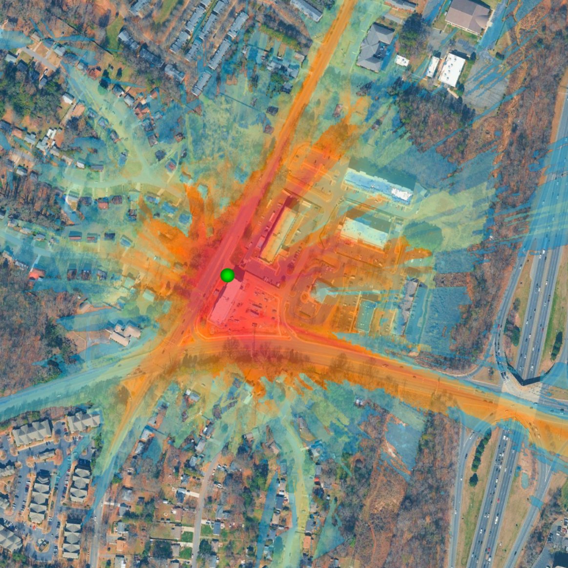
Frustrated by traffic? 🚗💨 What if roads could tell us what's next?
Mobility infrastructure management leader @Abertis uses our Roads Management Insights to turn mobility data into powerful foresight, making your journeys smoother and safer.
RMI's unique combination of data quality, granularity, and the ability to operationalize insights through a scalable analytics environment allows Abertis to move beyond descriptive reporting toward proactive management.
See how we're making roads smarter, together → https://t.co/vjE1vbWV3i
Lovable's Google connectors are live.
You can now build full-stack apps that talk directly to data from Google: Gmail, Calendar, Drive, Sheets, Slides, Maps, Gemini Enterprise, and BigQuery.
🔎 Search the globe using simple descriptions. New AI models from Earth AI let you find objects like wind turbines or rivers across the planet without complex coding. ➡️ https://t.co/pAnlpWX9qQ
It's been 20 years since the first Geo Developer Day, and we've come so far! This #GoogleIO, we showcased:
❓ Ask Maps, allowing Google to help you in new ways
🔍 AI Mode in search, powering Google Maps for personal intelligence use cases
👁🗨 Street View imagery in DeepMind’s Project Genie, so you can anchor interactive worlds in reality
Here's the latest from Google Maps Platform ➡️ https://t.co/zG9XvHnuwH
🛠️ Measure utility poles and road signs from your desk. New LiDAR data in Street View Insights, part of Earth AI, turns weeks of manual field work into minutes of digital analysis. Learn more ➡️ https://t.co/UMYgyg24bY
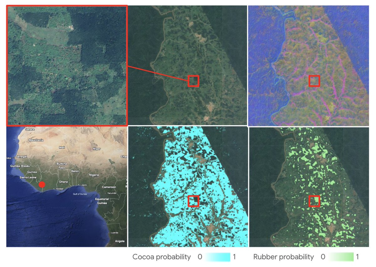
Today, we're excited to announce a major milestone in spatial transparency: the launch of annual, global commodity tree crop maps (coffee, cocoa, oil palm and rubber) built with Google’s Satellite Embedding dataset, part of Google Earth AI. https://t.co/CO5Hjvn9yK
This dataset represents the first pan-tropical, open source, 10-meter resolution map for cocoa, coffee, and rubber, key commodity tree crops associated with deforestation.
These maps are a core output of the Forest Data Partnership (FDaP), a global consortium dedicated to halting forest loss by collaboratively improving monitoring and supply chain tracking. By scaling our coverage from individual countries to the entire tropical belt, we’re closing a critical data gap that has hindered conservation efforts for decades.
🚪 Get a glimpse at the #GoogleIO experience with our real-world AI demo!
Avoid image hallucinations with Google Maps Street View in Maps Imagery Grounding, which grounds AI outputs with location data. 🌍
Watch Alexa Anastasio recreate the Shoreline Amphitheater in an origami style! Learn more ➡️ https://t.co/OZPX3mLG0f
💡 Add real-time, authoritative location intelligence into your AI workflows using Google Maps Platform Grounding Lite as an MCP server.
Join Caio and Ken from our Developer Experience team for #GoogleIO to learn how Places Search, Weather Lookup, and Routing combine to give your AI reliable geospatial data.
Eliminate location-based hallucinations ➡️ https://t.co/lXUNl93l0b
🚨 We're live! DevX Engineers Ryan Baumann and Teresa Qin offer their insight on real-time reasoning agents, plus answer your submitted questions. Learn to:
🪄 Move from deterministic engineering to probabilistic orchestration
😶🌫️ Avoid cascading hallucination problems for autonomous agents
🏗️ Bridge the gap between AI logic and physical reality
👀 ➡️ https://t.co/Z64zgYBsrv
📢 Join DevX Engineers Ryan Baumann and Teresa Qin on May 15 for a conversation about building trustworthy, real-time reasoning Agents.
They'll examine usecases for maps and agents, talk through agent architectures, and answer your submitted questions!
Join the Google Maps Platform Discord now and be the first to watch ➡️ https://t.co/faInChbJc1?
🌍 Using Earth AI, we're combining high-res satellite views with Street View, so now businesses can track regional trends and zoom into street-level details all in one place.
Learn more ➡️ https://t.co/bgVQcVzM0s
#GoogleMapsPlatform#Geospatial
🧊📍 Our 3D Maps and hyper-granular information about places let you deliver the ultimate map experience with:
new programmable camera settings
custom HTML place markers
mesh flattening for a clean canvas
Create a photorealistic world, then weave in your brand identity and data ➡️ https://t.co/LiHTMR9PSP
🧠💡 Ready to build trustworthy, real-time reasoning Agents?
Join Google Maps Platform DevX Engineers Ryan Baumann and Teresa Qin on May 15 on Discord to catch our second fireside chat, where Ryan and Teresa will discuss building agents that reason over up-to-date places, routes, weather, and more.
They'll also answer your questions about maps and agent use cases and agent architecture. Join the Google Maps Platform Discord ➡️ https://t.co/ETW3HLPhj4?