Please make sure all debris caused by #Imelda is ready for pickup by Monday, Oct. 14. Debris crews will begin pickup in Orange and Hardin County before moving on to Jefferson, Chambers and Newton County
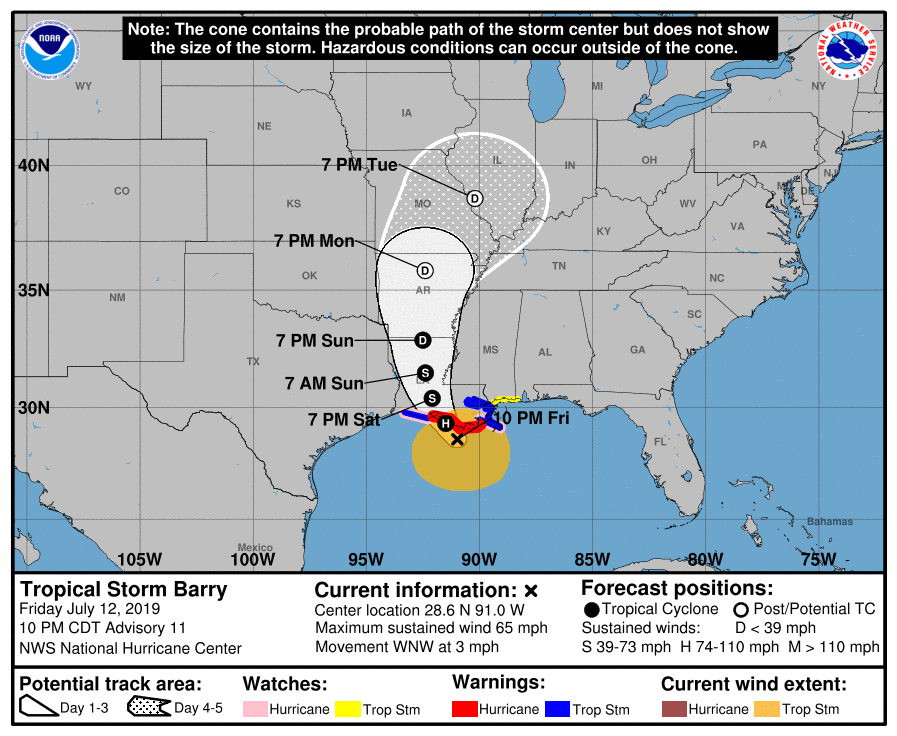
Here is the 10:00 PM advisory from NHC on Tropical Storm Barry. Maximum sustained winds remain near 65 MPH and the forecast track continues to indicate a landfall between Morgan City and Vermilion bay tomorrow morning as a minimal category 1 hurricane (75 MPH winds).
Household Hazardous Waste and Tire Collection Event THIS SATURDAY
8am - 1pm
Silsbee High School
1575 Highway 96 North - Silsbee
During this free event, the SETRPC is collecting items that could cause damage to... https://t.co/hu0eEpgFAK
***** Weekly Weather Update 4-25-2019 *****
After today's round of strong to severe thunderstorms, dry weather is expected Friday through Monday. A low chance of showers and thunderstorms is forecasted for Tuesday and... https://t.co/dMQX0aQKV7
***** Weather Alert 4-24-2019 *****
The Storm Prediction Center is still carrying a marginal to slight risk (5-15%) for severe storms for our region. The timing of the storms will be between midnight and 6 am Thursday... https://t.co/FEKnnnUP4e
***** Weather Alert 4-16-2019 *****
The Storm Prediction Center is outlining a marginal (5%) to slight (15%) threat for strong to severe storms, starting in southeast Texas late Wednesday/early Thursday, then... https://t.co/QkVCdZApps
Weather Update 4-5-2019
The National Weather Service in Lake Charles is expecting less of a threat for severe weather late Saturday or early Sunday. There still remains a slight risk for severe storms all day Sunday,... https://t.co/gpyx0XPtvM
Weather Update 4-3-2019
An unsettled weather pattern will begin overnight with showers and thunderstorms expected through early next week.
There is a slight risk for severe storms (Hail/Tornadoes) during the... https://t.co/2Odioglval
***** Weekly Weather Update 3-7-2019 *****
Minor river flooding on the Sabine River near Deweyville will continue.
Small rain chances on Friday increase into the weekend, when there is a threat for a few strong to... https://t.co/uiaEfDq1zq
***** Weekley Weather Update 2/28/2019 *****
Scattered showers and thunderstorms this afternoon will weaken and dissipate later tonight. A few showers and thunderstorms will return Friday and Saturday.
Rain chances are... https://t.co/Z8cn8n5sns
***** Weekly Weather Update 2-15-19 *****
Temperatures will run 10 to 15 degrees above normal for overnight low temperatures for the next 7 days. This will result in patchy dense fog at times, especially along... https://t.co/x5yOU4QfDT
***** Weather Update 2-7-2019 *****
As a cold front moves across our region today, temperatures will run below normal tonight through Saturday, and return to normal or above next week.
Mostly cloudy skies are expected... https://t.co/7pdm4tbfHd
***** Weekly Weather Update 2/1/2019 *****
Temperatures will run above normal for much of the next 7 days.
There will be scattered showers and a few thunderstorms every day. No widespread severe storms are expected.... https://t.co/860LvwGqA7
***** Weather Alert 1-28-2019 *****
A cold front will move through the area tonight into Tuesday morning accompanied by scattered showers.
Much colder air will move in behind the front. Lingering precipitation behind... https://t.co/0KBiV7FDlN
***** Weekly Weather Update 1-24-19 *****
Temperatures will run below normal to near normal for the next 7 days. Freezing temperatures are expected Friday and Saturday morning in some places, as well as next... https://t.co/mGzcy5bEA3
***** Weekly Weather Update 1-17-2019 *****
Scattered showers and thunderstorms will increase in coverage late Friday through Saturday morning. There is a low threat for strong to severe storms. Rain totals... https://t.co/AfHmT0azk0
***** Weekly Weather Update 1-10-19 *****
Rivers that are flooding have crested everywhere except along the Atchafalaya River, where Morgan City won’t see their flat crest for a couple more weeks.
Dry weather... https://t.co/6S5LYOZaGY