Top Tweets for #BCSTORMWATCH

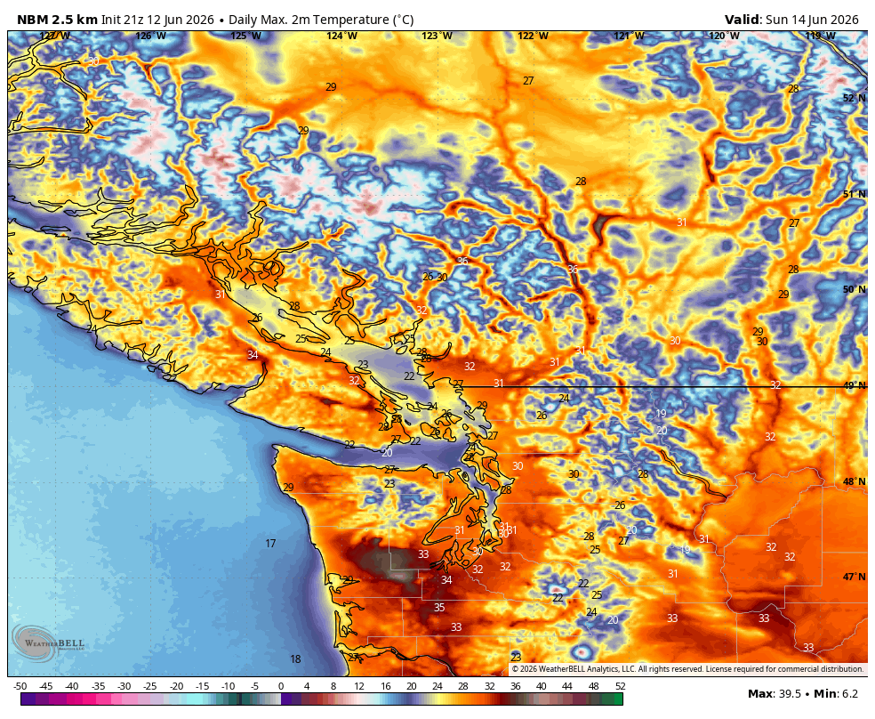
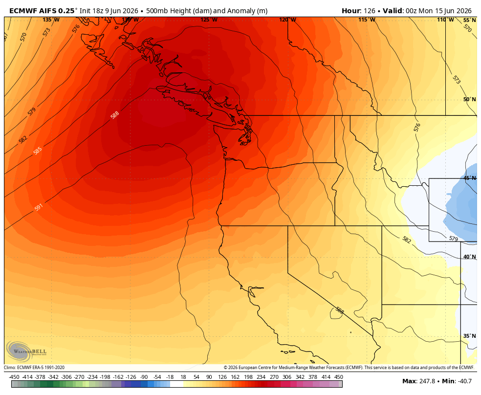
Warmest day's on #VancouverIsland look to be Sun/Mon. Expect 31-32C around #Nanaimo and up to 35C for areas Inland.
#BCHeat #BCWx #BCStormWatch #Heatwave #PNW #Forecast #News


#BCStorm #BCwx #BCStormWatch
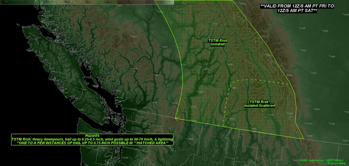
Overall, across most (if not all) of Southern BC, from late this afternoon to early Saturday morning, <1-5 mm to up to 15-25 mm of rain is expected.
Both the highest totals, & greatest possibility for locally higher totals, will tend to occur in higher elevations &/or where moderate-heavy rain/convection &/or any t-storm(s) pass over (particularly continuously/repeatedly).

#BCStorm #BCwx #BCStormWatch
As for the Interior isolated-scattered t-storm threat that'll accompany the rain/convection during the late morning-eve period, it'll be driven by the aforementioned upper-level shortwaves & associated cold, (mostly-entirely) NW flow, in tandem with marginal instability, daytime heating, & weak deep-layer shear, as well as orographic lift, steep lapse rates, & any weak SFC features.
Heavy downpours, hail up to 0.25-0.5 inches/~0.5-1.25 cm, and wind gusts up to 50-70 km/h will be the main concerns in non-TSTM/TSTM convection tonight & tmrw. However, in SE BC, one to a few instances of hail up to 0.75 inch/~2 cm will be possible tmrw aft.


#BCStorm #BCwx #BCStormWatch
That won't last long, however, as patchy-widespread rain/convection, w/ the risk of isolated-scattered t-storms, will then get underway in the Interior around late tmrw morning. Rain/convection will begin to slowly diminish around mid or late aft as the BC-side shortwave fully moves out of the region, with only a few areas of isolated rain/convection expected to remain by late eve, mainly-entirely in the Koots, which'll remain the case through the rest of tmrw night. The t-storm threat itself will come to a close late eve or early overnight tonight.


#BCStorm #BCwx #BCStormWatch
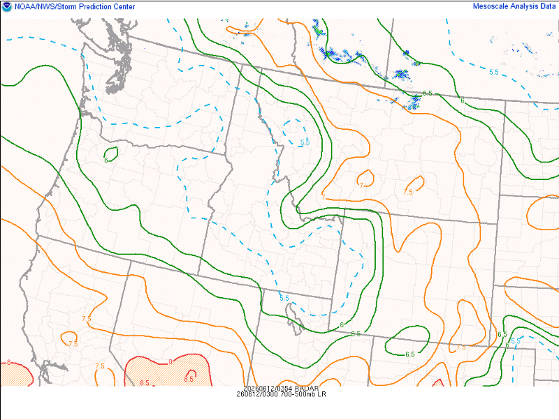
As for tonight, weak instability & 15-25 to upwards of 45-65 kts of deep-layer shear, in tandem with orographic lift, 6.5-7.5 C/km mid-level lapse rates, & the elongated low/shortwave trough, this’ll lead to continued isolated-scattered/patchy rain/convection & the risk of isolated t-storms, which has been ongoing since this afternoon, through tonight across some-most of the Interior.
While the t-storm threat & convection will come to an end early or mid tmrw morning, isolated-scattered/patchy rain will continue to impact parts of the Koots-Columbias & potentially the North Thompson-Shuswap-Okanagan.


#BCStorm #BCwx #BCStormWatch
However, aloft, an elongated low stretching from West-Central BC to South-Southeast Central (roughly 100 Mile-Clinton, North Thompson, & Columbias) will remain relatively stalled over said areas & gradually convert turn into a shortwave trough tonight.
The shortwave will begin to sweep through Southern BC later tonight or early tmrw morning, before fully exiting the region by late aft tmrw.
Another shortwave, stretching across Alberta & into eastern sections of BC/the Koots-Columbias, will also affect the Interior late morning-early aft tmrw, through into tmrw night, before exiting stateside late tmrw night or early Saturday morning.
#BCStorm #BCwx #BCStormWatch
Southern BC - Late 6/11 to 6/12 Weather Update
Created @ 4 pm
Besides generic weak troughing &/or weak low(s), as well as a potential CF that'll work its way from the AB/Rockies into the Koots-Columbias tmrw, the SFC will remain relatively quiet the rest of today, tmrw, & tmrw night.


Quite the cell pushing over Port Coquitlam right now with torrential rain — don’t be surprised if you hear a rumble of thunder or two as this cell pushes in to the north shore mountains.
📍 DT PoCo | 1:50p PT | 9 June 2026
#ShareWeather #BCStorm #BCStormWatch #BCWX
#BCStorm #BCwx #BCStormWatch
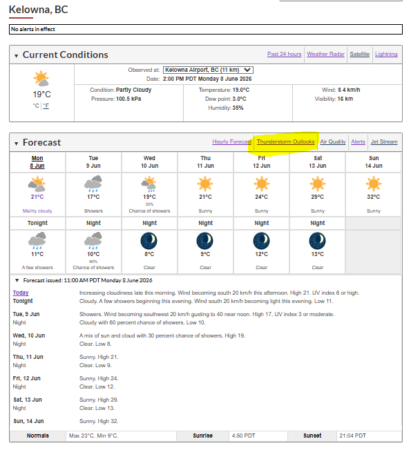
If you take a look at the Environment Canada website, you may notice something new...They have finally added their thunderstorm outlooks directly to their site! 🥳
Instead of needing to access them from a separate source (such as https://t.co/lkVShi1ATI), you can now access them simply by clicking "Thunderstorm Outlooks" just above your locality's 7-Day forecast.


Good morning Monday!
Red sky in morning, Sailor take warning!
#sunrise #goodmorning #June #bcstormwatch #Vancouver #hummingbird #Westcoast #redskyinthemorning #spring #summeriscoming
#shareyourweather


Yesterday's & today's ECCC outlooks, as well as my personal TSTM outlook, for late this morning-early evening's Interior thunderstorm potential.
#BCStorm #BCwx #BCStormWatch


#BCStorm #BCwx #BCStormWatch
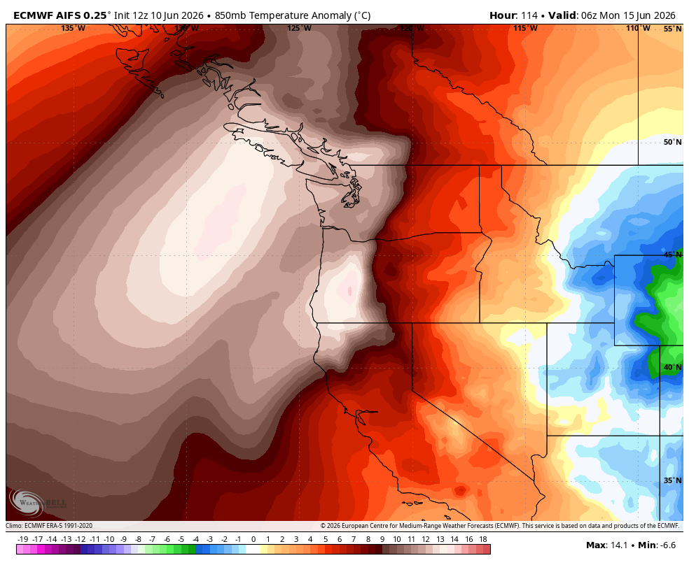
Today & tonight, a cold upper low, with related disturbances/troughing in its periphery, is expected to move across Southern BC, before making its way fully into Alberta tmrw morning. Then, from tmrw morning onward, a cold, NW-SW flow is expected, with the potential for one or more embedded disturbance(s), as weak ridging slowly passes overhead.
As for today, marginal instability, weak deep-layer shear (for most), & daytime heating, in tandem with orographic lift, steep lapse rates, weak SFC features (lows & troughing), & aformentioned upper level synoptics, this’ll lead to continued patchy-widespread precip/convection, which has been ongoing since yesterday, with the risk of isolated-locally scattered t-storms, from now, into this evening, across much of Southern BC.
While the t-storm threat & convection will come to a gradual end in the evening, patchy-widespread precip will continue to impact many areas/parts of the coast & Interior through tonight & into tmrw morning.
Patchy-widespread precip will continue to impact many parts/areas of Southern BC into tmrw aft, with convection & the risk of isolated t-storms in the Koots-Columbias, Okanagan-Shuswap, Similkameen, Nicola, & Thompson late tmrw morning-early eve. Precip/convection will begin to slowly diminish around early eve, with patchy precip expected mainly-entirely in parts of the Koots-Columbias & coast by late eve, remaining the case through the rest of tmrw night.
As for the Interior isolated t-storm threat that'll accompany the precip/convection during the late morning-early eve period, it'll be driven by the aforementioned cold upper-level flow with any embedded disturbances/shortwaves, in tandem with marginal instability, daytime heating, & weak deep-layer shear, as well as orographic lift, steep lapse rates, & weak SFC features (low(s) &/or trough(s)).
Heavy downpours (or snowfall in some high elevations), hail (or graupel/snow pellets in some higher elevations) up to 0.25-0.5 inches/~0.5-1.25 cm, and wind gusts up to 50-70 km/h will be the main concerns in non-TSTM/TSTM convection both days. A risk of waterspouts continues in the Georgia Strait & Howe Sound, but will come to an end within the next couple of hours or so.
Additional T-Storm Threat Notes
- W/ shear expected to be on the weaker side (≤25 kts) for the large majority (if not all) today & tmrw, it's expected that the majority-all of today's & tmrw's convection (non-TSTM/TSTM) will be short-lived (popcorn/pulse type; generally quick maturity before weakening, lasting no more then ~30-60 mins), which'll also tend to result in non-TSTM/TSTM collisions/interactions due to the lack of organization & relatively slow storm motions.
- As well, today's & tmrw's storms will tend to favour the higher elevations/ridgetops (at least initial development) due to the weaker shear/steering coinciding w/ greater lift (orographic lift) & associated thermodynamic environment (ie. dry/drier lower elevations/valleys).


Convection over the North Shore mountains trying so hard to be thunderstorms but the flow now more NWly, the cumulonimbi die as they move into the more stable air of the lowlands. The best dynamics having since moved into southern Washington State.
#BCstorm #BCstormwatch #BCwx


As expected, just like the rest of the storms today, it lasted about 20 minutes or so before weakening.
The lingering showers have kept that nice & menacing look though.
(#Kelowna #BC)
#BCStorm #BCwx #BCStormWatch #ShareYourWeather


Watching a neat thunderstorm work its way along the Westside from #Kelowna.
#BCStorm #BCwx #BCStormWatch #ShareYourWeather


Last Seen Hashtags on Sotwe
logoadaptatif
Seen from United States
任せていたら来年になりそう
Seen from United States
كبلز_الخرج
Seen from Saudi Arabia
horny brush
Seen from Mexico
bursatravesti
Seen from Turkey
mk240901
Seen from United States
liselikiz
Seen from Turkey
omegle
Seen from United States
momson() +filter:media()
Seen from Brazil
هديل_انور
Seen from United States
Most Popular Users

Elon Musk 
@elonmusk
240.2M followers

Barack Obama
@barackobama
119.3M followers

Donald J. Trump
@realdonaldtrump
111.6M followers

Cristiano Ronaldo
@cristiano
109.4M followers

Narendra Modi
@narendramodi
106.9M followers

Rihanna
@rihanna
97.4M followers

NASA
@nasa
92.1M followers

Justin Bieber
@justinbieber
90.7M followers

KATY PERRY
@katyperry
87.1M followers

Taylor Swift
@taylorswift13
80.9M followers

Lady Gaga
@ladygaga
72.4M followers

Kim Kardashian
@kimkardashian
69.5M followers

Virat Kohli
@imvkohli
68.9M followers

YouTube
@youtube
68.6M followers

Bill Gates
@billgates
63.5M followers

The Ellen Show
@theellenshow
62.5M followers

CNN
@cnn
61.9M followers

Neymar Jr
@neymarjr
61.5M followers

X
@x
60.9M followers

Selena Gomez
@selenagomez
60.1M followers