Top Tweets for #FireMap

🔥 Santa Rosa Island Fire Update
🗺️ Acres burned so far: 10,029🏝️ Total island size: 53,195 acres📊 18.85% of the island has burned
Live perimeter & spread tracking 👉 https://t.co/nltZKKiH39
#SantaRosaIsland #Wildfire #FireMap


El proyecto #Firemap de @unileon, presentado en los #TalleresCDFsobre tecnología, pone al alcance de gestores forestales, administraciones públicas, servicios de emergencia y comunidades locales análisis satelitales sin necesidad de conocimientos técnicos previos


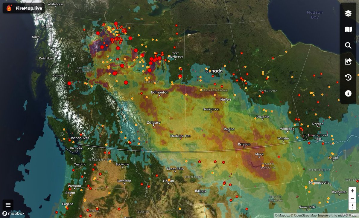
Curious about the smoke's source?
Wildfires in Alberta and NE BC are causing heavy smoke in Calgary, Edmonton, the Prairies, and ND. Lighter smoke drifts east toward Toronto and Chicago. Conditions should improve by Friday. View hourly smoke model updates on #FireMap🌎🌬️

FireMap is developing real-time wildfire smoke intelligence, launching soon.


@CityofSSF @SSFCERT_PIO @SSFfirefighters Thank you @CityofSSF for attending tonight’s Town Hall with @SSFFire Great turnout and questions! #FireMap #Awareness @SSFCERT_PIO @CALFIRECZU

🚨 Palisades Fire Expands to 15,832 Acres
Today, the Palisades Fire has pushed west into Tuna Canyon en route to Malibu, now burning 15,832 acres. Check out #FireMap for real-time satellite hotspots and track the fire’s movement. More boundary updates coming soon—stay informed and stay safe. #PalisadesWildfire

🚨 Breaking News: Wildfires rage across Southern California, with Pacific Palisades, Altadena, Pasadena, and Sylmar severely impacted. Over 2,900 acres .🔥
#CaliforniaFires #PalisadesFire #LAFire #LosAngeles #PasadenaFire #EatonFire #Wildfires #FireMap #LAnews #EmergencyUpdates


Does anyone have an accurate #firemap of the #Palisades #PalisadeFire? A very close friend’s mom is in the Ciela nursing home - they did not evacuate them but sheltered in place. My friend is desperately trying to reach her. Thank you (and prayers to all the first responders). 😔
@Weather_West For those looking for real-time mapping updates... see #FireMap and stay safe!
https://t.co/EJTgKUORbe
Tracking the Pacific Palisades Fire 🔥
Neal-time satellite hotspots and burned area boundaries on FireMap #PacificPalisadesFire
🔥 #FranklinFire Mapping Update: 4,037 Acres Burned
View our new 3D map on #FireMap. Satellite Hotspots are down, and we’re approaching final containment efforts. Stay safe, and thank you to all the crews working tirelessly.
#MalibuFires #MalibuWildfire
Usually its the parking lot that takes out nature, now nature is taking out a parking lot. See the location of this eruption on #FireMap #BlueLagoon #IcelandVolcano
https://t.co/ZHby7Ari2L


WATCH: Lava flows into Blue Lagoon car parking lot, destroys building after Iceland volcano erupts again
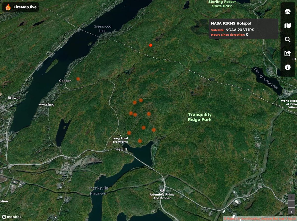
Here's the location of the Jennings Creek Fire on the New York-New Jersey border. Map shows proximity to New York. Stay tuned to #FireMap for data updates.
https://t.co/NSymLxMxLj
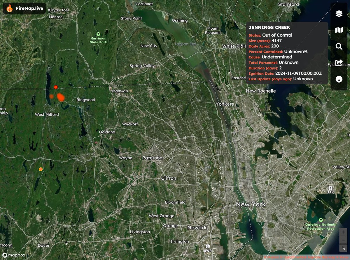

The Jennings Creek wildfire has now scorched more than 5,000 acres along the New York-New Jersey border. @trevorlault has the latest on the blaze.
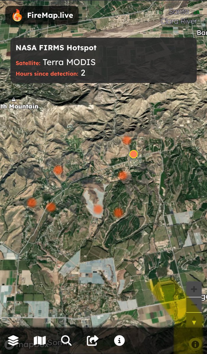
🚨 #MountainFire Update 🚨
The fire has expanded down the north slope of South Mountain toward Santa Paula. Be prepared to evacuate if necessary. Live mapping updates are being streamed into FireMap—stay tuned for real-time information.
#VenturaCounty #SantaPaula #FireMap #StaySafe
We are starting to see a few satellite, hotspots on #FireMap for #MountainFire. Safe to say this one is going to cover a significant area is in the region evacuate to be on the safe side.

⚠️UPDATE⚠️The fire has jumped SR-118 west of Somis and there are now MANDATORY evacuations south of SR-118. Check https://t.co/oGZ5GvEU1I for up to the minute details on the #MountainFire.
Preliminary Location for #BroadFire in Malibu.
At this time, there are no defined boundaries or hotspots. Firefighters are actively engaged, with efforts complicated by the location. Stay tuned to #firemap for the latest updates on this developing situation. Remember, high winds and dry conditions increase the risk of fire spread. #MalibuFire #FireSafety
@weatherchannel @FeliciaCombsTWC Thank you for the update, @FeliciaCombsTWC. The combination of high winds and dry conditions creates an extremely dangerous situation. We’ll be closely monitoring the real-time updates on #FireMap to stay informed. Stay safe, California!
@or_bit_eye @HotshotWake @ECOWARRIORSS @Weather_West @AlanaBrophyWX @BrienReports @UtahWildfire @brian_schnee @tvheidihatch @youtah @NWSSaltLakeCity Nice image, its certainly interesting terrain near #YellowLakeFire. Here is what it looks like in 3D on #FireMap
https://t.co/74sxSFJVEU
Yellow Lake Fire Explodes to 15,000 Acres; Evacuations Continue as Crews Battle Aggressive Blaze
#FireMap #YellowLakeFire #SaltLakeCity #Utah
Yellow Lake Fire Explodes to 15,000 Acres; Evacuations Continue as Crews Battle Aggressive Blaze
#FireMap #YellowLakeFire #SaltLakeCity #Utah
Last Seen Hashtags on Sotwe
Trends for you
Most Popular Users

Elon Musk 
@elonmusk
240.2M followers

Barack Obama
@barackobama
119.3M followers

Donald J. Trump
@realdonaldtrump
111.6M followers

Cristiano Ronaldo
@cristiano
109.1M followers

Narendra Modi
@narendramodi
107M followers

Rihanna
@rihanna
97.3M followers

NASA
@nasa
92.1M followers

Justin Bieber
@justinbieber
90.6M followers

KATY PERRY
@katyperry
86.9M followers

Taylor Swift
@taylorswift13
80.7M followers

Lady Gaga
@ladygaga
72.3M followers

Kim Kardashian
@kimkardashian
69.4M followers

Virat Kohli
@imvkohli
68.7M followers

YouTube
@youtube
68.6M followers

Bill Gates
@billgates
63.5M followers

The Ellen Show
@theellenshow
62.5M followers

CNN
@cnn
61.9M followers

Neymar Jr
@neymarjr
61.3M followers

X
@x
60.9M followers

Selena Gomez
@selenagomez
60M followers