Top Tweets for #Firemapping

New drone fleet strengthens emergency response
#ausnews #cfa #vicnews #fire #summer #bushfires #science #technology #drones #firemapping #firespotting #firefighting #region13 #ffmv https://t.co/7AC7yiK3fT

The MTBS @QGIS #FireMapping Tool has been updated! This #OpenSource tool, developed by EROS and the @ForestService GTAC, allows users to assess the impacts of fires before MTBS assessments are published. Download it here: https://t.co/MRkVrThQ1F
#FireScience #Landsat #Sentinel2


A Lightweight Remote Sensing Payload for Wildfire Detection and Fire Radiative Power Measurements
https://t.co/eDJA6skODR
#Wildfires #FireRadiativePower #FireTemperature #FireMapping


This is a story about wide-angle imaging for #firemapping and maritime search but it’s also a story about changing the culture and getting people to trust a new way of doing things.
https://t.co/kNNnkf9xIU

Great work @OroraTech!😍
Love these, thanks for the late night tag!
Comparing to the survey flight up; Part 1 is now complete & moving onto Part 2 for fresh am fire maps!
#ORfire #CAfire #firemapping

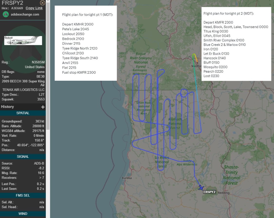

#Wildfires continue to rage in Northern #California, sparked by lightning strikes and fueled by recent hot weather. The largest, Smith River Complex fire, covers 83,000 acres (33,589 ha). Smoke has blanketed the Bay Area. Relief is expected soon due to the rain forecast. 🔥


#CaldorFire #MultipleCounties #LakeTahoe #CA #NV #USA #FireWeather #FireMapping
Hoping all remaining in affected areas have firm #EvacuationPlans
https://t.co/StFeKf3OSj

Gotta say, the outlook for the #CaldorFire is not good. With fire established on both sides of 50 east of #Strawberry and crescendoing SW winds for the next 48 hrs (including at night) it is hard to imagine scenarios in which it doesn't make a run toward Hwy 89 south of #Meyers.


Great work by the crews hitting the 25 Mile Fire on lake Chelan. Looks like just a few hot spots left to mop up. #twentyfivemilefire #firemapping #firemapper #firemap @MtAdamsInf @waDNR_fire @BLMOregon

How technology in the air battles fires on the ground - BBC News #firemap #firemapping #firemapper @waDNR_fire @EWFIREANDHAZARD @wildfiretoday @BCWildfireHelp @wildfirenews https://t.co/wgTPRQy3uh
@Coldsalt @waDNR_fire @NWCCInfo @MtAdamsInf WOW! 🔥🌋✈️
Awesome work @Coldsalt!
Check this out #firetwitter tech: @CAFireScanner @barkflight @ai6yrham @RobMayeda @US_Stormwatch @8bitmeme @mn_storm @BranomJaeden @JhawkFire
#wildfire #wildfiretech #aerialfirefighting #fireGIS
#firemapping #firemappers #firewx #cafire #cawx
Clouds stopped us from getting all of the #twentyfivemilefire. @waDNR_fire @MtAdamsInf @NWCCInfo #WAwildfire #firemapping #mappingfire


Miss the premiere episode of #AdvancingAustralia?
Here’s a link to the episode as we discuss the use of aerial fire mapping technologies to combat bushfires in Australia: https://t.co/0rTqM1RJlX
#bushfire #firemapping #innovation
Tune in to our TV debut tonight! In #AdvancingAustralia, hosted by the legendary @TheGuyPearce, we will be tackling the issue of wildfires with our innovative bushfire-mapping tech.
Tune in to @Channel10AU and 10 play at 6pm.
#bushfire #firemapping #innovation

“Fires today are more intense, more widespread and more frequent. We now have fires that are becoming almost too big to fight.” Dr Paul Dare talks the need for new innovations and #firemapping like FireFlight in our TV debut for #AdvancingAustralia on @Channel10AU. #bushfires

Getting ready to spin into Monday! The FVR-90 UAV is capable of staying aloft up to 13 hours! #keepingpeoplesafe
#aerialfirefighter #aerialfirefighting #L3Harris #fvr90 #uav #uas #drone #Carbonfiber #Wildfire #wildlandfire #surveillance #firemapping #situationalawareness

Great view of a controlled burn in the Ngarkat Conservation Park last week.
#firemapping #controlledburn #prescribedburn


Mapping and surveying the Cinnabar Fire. A Zoom Meeting allows fire Managers to view a live camera feed from the UAV!
#l3harris #fvr90 #firemapping #firefighting #aviation #UAS #UAV #drone #aerialfirefighting #wildlandfire #firefighters #Cinnabarfire #surveillance #realtime


🛩🔥🚁 “This month the Orange County Fire Authority began a 150-day pilot program that could lead to real time fire mapping being available to firefighters on the ground.“ @OCFAChief #OCFA @PIOthanhn #wildfires #FireMapping #RemoteSensing

Don’t Miss This => Orange County begins trial of real time mapping technology https://t.co/nCG4rW3Bq4 via @FireAviation #wildfires #firemapping #IRmapping #hightech @RSFireNerd @JohnAFisher @JhawkFire @Bewickwren @wildfirediva (Kudos to @FireAviation for sharing this great info.)
Don’t Miss This => Orange County begins trial of real time mapping technology https://t.co/nCG4rW3Bq4 via @FireAviation #wildfires #firemapping #IRmapping #hightech @RSFireNerd @JohnAFisher @JhawkFire @Bewickwren @wildfirediva (Kudos to @FireAviation for sharing this great info.)
Last Seen Hashtags on Sotwe
EstudiosDeSuelo
Seen from Argentina
ファンウン
Seen from Japan
pussy
Seen from Germany
carlesson
Seen from Belgium
กลุ่มไลน์หนังโป๊
Seen from Thailand
BigAss
Seen from Turkey
ACFirstCivVP
Seen from Brazil
marasesc
Seen from Turkey
ห้องน้ำปั้ม
Seen from Thailand
exny or #nolimit() #momson() +filter:native_video
Seen from Turkey
Most Popular Users

Elon Musk 
@elonmusk
240.2M followers

Barack Obama
@barackobama
119.3M followers

Donald J. Trump
@realdonaldtrump
111.6M followers

Cristiano Ronaldo
@cristiano
109.1M followers

Narendra Modi
@narendramodi
107M followers

Rihanna
@rihanna
97.3M followers

NASA
@nasa
92.1M followers

Justin Bieber
@justinbieber
90.6M followers

KATY PERRY
@katyperry
86.9M followers

Taylor Swift
@taylorswift13
80.7M followers

Lady Gaga
@ladygaga
72.3M followers

Kim Kardashian
@kimkardashian
69.4M followers

Virat Kohli
@imvkohli
68.7M followers

YouTube
@youtube
68.6M followers

Bill Gates
@billgates
63.5M followers

The Ellen Show
@theellenshow
62.5M followers

CNN
@cnn
61.9M followers

Neymar Jr
@neymarjr
61.3M followers

X
@x
60.9M followers

Selena Gomez
@selenagomez
60M followers