Top Tweets for #GeoColor

View of the Tropical Atlantic basin today 06/08 real-time #GOESEast ABI Full Disk RGB #GeoColor product. See a hi-res version here-> https://t.co/pJAvT92hJ9 #RealEarth™ #UWCIMSS @SSECRealEarth
View of the Tropical Atlantic basin today 06/05 real-time #GOESEast ABI Full Disk RGB #GeoColor product. See a hi-res version here-> https://t.co/enQmPZBBhD #RealEarth™ #UWCIMSS @SSECRealEarth

This #FullDiskFriday, we thought we'd show this #GeoColor imagery from @NOAA's #GOESWest 🛰️ with wind vectors overlaid.
These different-colored barbs indicate wind direction and speed at different heights in the atmosphere (Red: high altitude, Cyan: mid-altitude, and Yellow: low altitude). #GOES18
More about this type of imagery:
https://t.co/8sg5jXetm5
This #FullDiskFriday, we are looking at the Atlantic Ocean with #GeoColor imagery via @NOAA's #GOESEast.
In this view, you can see the remnants of #TropicalStorm #Dexter and the #smoke moving over the ocean from Canadian #wildfires. Also notice the #SaharanDust blowing off of Africa! #GOES19
What's the weather where you live? https://t.co/FdGeSaDQXa
Did you see it? Some areas in the eastern U.S. were treated to a partial #SolarEclipse last Saturday and @NOAA’s #GOESEast 🛰️ had a great view!
In this #GeoColor imagery, you can see the moon’s shadow as it passed over parts of the Northern Hemisphere.
#GOES16
In this time-lapse from today, we are looking at #GeoColor imagery from @NOAA’s #GOESEast 🛰️ overlaid with wind barbs from various levels of the atmosphere. Those can help forecasters determine jet streams and areas of wind shear.
Happy #FullDiskFriday everyone!
.@NOAA's #GOESEast 🛰️ is tracking blowing #dust across parts of the Southwest this afternoon.
The #GeoColor imagery on top shows the dust as it appears to the human eye. The imagery on the bottom enhances the blowing dust as yellow to help it stand out.
A #BlowingDust Advisory is in effect for parts of NM and AZ.
Imagery via @NOAA's #GOESEast 🛰️ shows two views of lake effect snow coating the ground around the Great Lakes yesterday. The #GeoColor imagery shows the bright white snow under the moving clouds, while the enhanced color imagery helps differentiate this snow (light green) from the clouds above (pink/yellow).
This 7-hour #GeoColor/#FireTemperature imagery from @NOAA’s #GOESEast satellite shows the #JenningsCreek fire burning along the New York/New Jersey border on Saturday. The fire has recently grown to more than 5,000 acres and a #RedFlagWarning remains in effect for the region.
#TimelapseTuesday


🛰️❱ Animación #GOES-16 [#Geocolor - Ash EUMASAT]
Oct 23, 2024 [12:00-23:30 | GMT-6]
La pluma de cenizas del #Popocatépetl ya se extiende a +110km de longitud, dirección N-NO, cobertura a 6 estados del país:
= #EDOMEX (Chalco - Tecámac)
= #CDMX (Iztapalapa, V.C, GAM)
= #Hidalgo (Altiplano, Pachuca)
= #Tlaxcala (Calpulalpan)
= #Puebla (Texmelucan)
= #Veracruz (Huasteca Baja)
We never get tired of this #GeoColor view of our part of the world. This #FullDiskFriday image was captured with @NOAA's #GOESEast 🛰️ today, as it watched from geostationary orbit.
There’s always a lot to see when looking back at Earth from space. What’s catching your eye in this imagery? 🌎🔍
Here’s the latest #GeoColor/#GLM imagery of Category 3 #Hurricane #Helene from @NOAA's #GOESEast satellite.
Get details on the powerful storm: https://t.co/6J6oQkh3F3

Hurricane #Helene Advisory 14: Helene is a Very Dangerous and Large Major Hurricane. Damaging Hurricane Winds and Catastrophic Storm Surge Expected to Begin in the Florida Big Bend This Evening. https://t.co/tW4KeGe9uJ
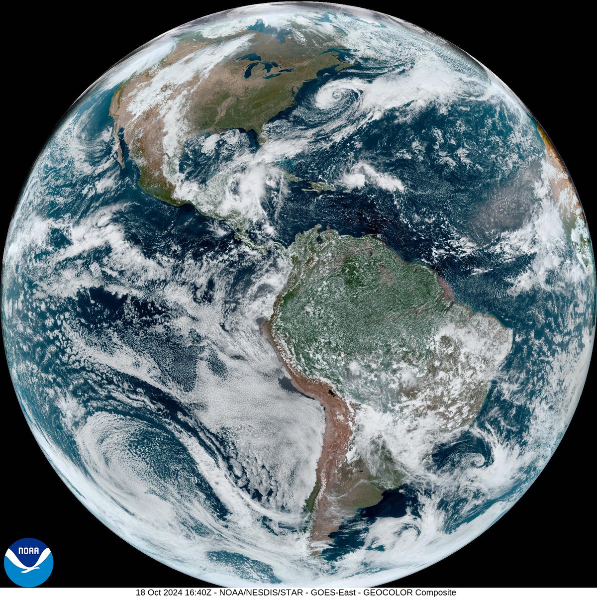
We never get tired of this #GeoColor view of Earth. This #FullDiskFriday image was captured with @NOAA's #GOESEast 🛰️ today, as it watched over us from orbit.
There’s always a lot to see when looking back at Earth from space. What’s catching your eye in this imagery? 🌎🔍

For #TimelapseTuesday, we're reviewing this 8-hour #GeoColor/infrared imagery from @NOAA’s #GOESEast satellite, which tracked a #derecho moving across the Midwest yesterday evening.
The severe storms produced destructive wind gusts and spawned a tornado near Des Moines, Iowa.

🌀🛰️ Increíbles imágenes captadas por #GeoColor del satélite #GOESEast de @NOAA muestran la evolución de #Beryl en sus primeros 4 días, desde tormenta en el Atlántico hasta ciclón tropical y finalmente huracán categoría 5 en el mar Caribe. 🌊🌪️ #HuracánBeryl
📹 @NOAASatellites
For #TimelapseTuesday, this #GeoColor imagery from @NOAA's #GOESEast satellite shows the first 4-days of #Beryl, when the storm grew from a tropical cyclone in the western Atlantic Ocean to a category 5 hurricane in the Caribbean Sea.
More on #HurricaneBeryl: https://t.co/g8o6QiThXB
Trends for you
Most Popular Users

Elon Musk 
@elonmusk
240.2M followers

Barack Obama
@barackobama
119.3M followers

Donald J. Trump
@realdonaldtrump
111.6M followers

Cristiano Ronaldo
@cristiano
109.1M followers

Narendra Modi
@narendramodi
107M followers

Rihanna
@rihanna
97.3M followers

NASA
@nasa
92.1M followers

Justin Bieber
@justinbieber
90.6M followers

KATY PERRY
@katyperry
86.9M followers

Taylor Swift
@taylorswift13
80.7M followers

Lady Gaga
@ladygaga
72.3M followers

Kim Kardashian
@kimkardashian
69.4M followers

Virat Kohli
@imvkohli
68.7M followers

YouTube
@youtube
68.6M followers

Bill Gates
@billgates
63.5M followers

The Ellen Show
@theellenshow
62.5M followers

CNN
@cnn
61.9M followers

Neymar Jr
@neymarjr
61.3M followers

X
@x
60.9M followers

Selena Gomez
@selenagomez
60M followers