

Top Tweets for #Hvm


Please upgrade to v1.2.3 as soon as possible. This is a long-term stable version since the Istanbul upgrade, with HVM virtual machine capabilities basically set, and there won't be any full-node version updates in the short term.
https://t.co/5NUv39JLPZ

Please upgrade to v1.2.3 as soon as possible. This is a long-term stable version since the Istanbul upgrade, with HVM virtual machine capabilities basically set, and there won't be any full-node version updates in the short term.
https://t.co/5NUv39JLPZ


Nandritra ny Kongresy HVM tao Antananarivo, nanamafy ny fanohanany ny Fitondrana Fanavaozana ny antoko, niantso fifidianana madio sy mangarahara, ary nanasongadina ny firaisam-pirenena sy ny fanohanana ny tanora, ny vehivavy ary ny fampandrosoana ara-toekarena.
#HVM #Fanavaozana

@SilvanaNHR 🇨🇱🇺🇸 | #HVM #HV3 +1. | El país debe tener el @LockheedMartin F-35 Lightning II.
Es sobrevivencia geopolítica..

🇨🇱⚡️🇦🇷 | #HVM #HV3 + 1. #CamposDeHielosSur #Chaiten #Coyhaique #VillaOhiggins #PuertoNatales #PuntaArenas #puq | #Chile no ha perdido nada, ante la traición y el delito de Lesa Patria de toda nuestra propia clase política.
@CDE_CHILE
@FiscaliadeChile
@PJudicialChile
📽 | Gentileza del Canal de YT #PortalPatriota.. https://t.co/14sIIluNII
🇨🇱⚡️🇦🇷 | #Coyhaique #VillaOhiggins #PuntaArenas #puq | #Chile dividido en dos y esta boca no es mía.. @GobiernodeChile ?
El mapa oficial argentino de #CamposDeHielosSur (Hielo Continental Patagónico) de la provincia de Santa Cruz, lo produce el Instituto Geográfico Nacional (IGN). Por la Ley de la Carta (Ley 22.963), esa es la cartografía que debe usarse en el país.
Edición de septiembre de 2016.
⚠️ | En el oeste se ve el campo de hielo, Fitz Roy/Chaltén, Agassiz y Stokes, con el límite internacional corrido según la línea que Argentina publica como oficial. "No aparece el rectángulo blanco del Acuerdo de 1998 que sí usan los mapas chilenos".
Descargas directas del IGN:
1.- Mapa político oficial:
[SANTA-CRUZ-POLITICO-WEB.jpg](https://t.co/rvFqshyPLg)
2.- Mapa satelital oficial:
[SANTA-CRUZ-SATELITAL-WEB.jpg](https://t.co/E93jog5VPT)
3.- Mapa Físico:
[SANTA-CRUZ-FISICO-WEB.jpg](https://t.co/2UM1G7Xxu7)
4.- Listado de mapas provinciales:
[https://t.co/VWnoAfDbpI](https://t.co/miAuDLYAaZ)
El mapa web del IGN es la fuente viva:
- Visor de mapas: [https://t.co/CIzuftTjKr](https://t.co/pj5iTGRkbD)
- Geoportal: [https://t.co/yYEU3zZH6B](https://t.co/KAlZLBA2p5)
- Argenmap (mapa base oficial para insertar en sitios): [https://t.co/PyJUOn70DV](https://t.co/jkpHCeN9YQ)
🔍 | Ahí se puede zoom al sector Fitz Roy–Murallón–Stokes y ver el límite y la toponimia oficiales.
⚠️ | Qué muestra la cartografía argentina ?
En los mapas IGN de Santa Cruz el límite oeste se traza como línea continua. Quedan del lado argentino, entre otros:
- Monte Fitz Roy / Chaltén (3.405 m)
- Cerro Agassiz (3.180 m)
- Monte Stokes (2.070 m)
- Glaciares y lagos orientales del hielo (Viedma, Argentino, San Martín)
No hay leyenda de “área pendiente de demarcación”. Eso es la diferencia con la cartografía oficial chilena, que marca un rectángulo con el texto del Acuerdo de Buenos Aires del 16 de diciembre de 1998 (Fitz Roy–Cerro Daudet).
⚠️ | En 2006, ante el reclamo chileno, el gobierno argentino dijo que esos mapas eran oficiales porque estaban aprobados por el entonces Instituto Geográfico Militar (hoy IGN). Esa línea se sigue usando.
Contexto breve:
El Campo de Hielo Patagónico Sur está entre ~48°15′ S y ~51°30′ S. Hay un tramo **aún no demarcado** entre el Fitz Roy y el cerro Murallón/Daudet. El Acuerdo de 1998 creó una comisión mixta para fijar esa línea; el trabajo no está cerrado. Por eso Chile dibuja el rectángulo y Argentina, en su cartografía oficial, dibuja su pretensión como límite.
Hay también un mapa argentino de 1912 (Anuario Oficial) con los hitos que citaban los peritos de ambos países; es histórico, no el vigente.
Si necesitás el recorte a escala grande (Fitz Roy–Circo de los Altares–Stokes) o las capas SIG del IGN (límites, glaciares, toponimia), lo armo a partir del visor y de las capas abiertas.

2.- Mapa satelital oficial:
[SANTA-CRUZ-SATELITAL-WEB.jpg](https://t.co/E93jog5VPT)
3.- Mapa Físico:
[SANTA-CRUZ-FISICO-WEB.jpg](https://t.co/2UM1G7Xxu7)
4.- Listado de mapas provinciales:
[https://t.co/VWnoAfDbpI](https://t.co/miAuDLYAaZ)
El mapa web del IGN es la fuente viva:
- Visor de mapas: [https://t.co/CIzuftTjKr](https://t.co/pj5iTGRkbD)
- Geoportal: [https://t.co/yYEU3zZH6B](https://t.co/KAlZLBA2p5)
- Argenmap (mapa base oficial para insertar en sitios): [https://t.co/PyJUOn70DV](https://t.co/jkpHCeN9YQ)
🔍 | Ahí se puede zoom al sector Fitz Roy–Murallón–Stokes y ver el límite y la toponimia oficiales.
⚠️ | Qué muestra la cartografía argentina ?
En los mapas IGN de Santa Cruz el límite oeste se traza como línea continua. Quedan del lado argentino, entre otros:
- Monte Fitz Roy / Chaltén (3.405 m)
- Cerro Agassiz (3.180 m)
- Monte Stokes (2.070 m)
- Glaciares y lagos orientales del hielo (Viedma, Argentino, San Martín)
No hay leyenda de “área pendiente de demarcación”. Eso es la diferencia con la cartografía oficial chilena, que marca un rectángulo con el texto del Acuerdo de Buenos Aires del 16 de diciembre de 1998 (Fitz Roy–Cerro Daudet).
⚠️ | En 2006, ante el reclamo chileno, el gobierno argentino dijo que esos mapas eran oficiales porque estaban aprobados por el entonces Instituto Geográfico Militar (hoy IGN). Esa línea se sigue usando.
Contexto breve:
El Campo de Hielo Patagónico Sur está entre ~48°15′ S y ~51°30′ S. Hay un tramo **aún no demarcado** entre el Fitz Roy y el cerro Murallón/Daudet. El Acuerdo de 1998 creó una comisión mixta para fijar esa línea; el trabajo no está cerrado. Por eso Chile dibuja el rectángulo y Argentina, en su cartografía oficial, dibuja su pretensión como límite.
Hay también un mapa argentino de 1912 (Anuario Oficial) con los hitos que citaban los peritos de ambos países; es histórico, no el vigente.
Si necesitás el recorte a escala grande (Fitz Roy–Circo de los Altares–Stokes) o las capas SIG del IGN (límites, glaciares, toponimia), lo armo a partir del visor y de las capas abiertas.](https://pbs.twimg.com/media/HRt7YwuWsAAwS2P.jpg)

2.- Mapa satelital oficial:
[SANTA-CRUZ-SATELITAL-WEB.jpg](https://t.co/E93jog5VPT)
3.- Mapa Físico:
[SANTA-CRUZ-FISICO-WEB.jpg](https://t.co/2UM1G7Xxu7)
4.- Listado de mapas provinciales:
[https://t.co/VWnoAfDbpI](https://t.co/miAuDLYAaZ)
El mapa web del IGN es la fuente viva:
- Visor de mapas: [https://t.co/CIzuftTjKr](https://t.co/pj5iTGRkbD)
- Geoportal: [https://t.co/yYEU3zZH6B](https://t.co/KAlZLBA2p5)
- Argenmap (mapa base oficial para insertar en sitios): [https://t.co/PyJUOn70DV](https://t.co/jkpHCeN9YQ)
🔍 | Ahí se puede zoom al sector Fitz Roy–Murallón–Stokes y ver el límite y la toponimia oficiales.
⚠️ | Qué muestra la cartografía argentina ?
En los mapas IGN de Santa Cruz el límite oeste se traza como línea continua. Quedan del lado argentino, entre otros:
- Monte Fitz Roy / Chaltén (3.405 m)
- Cerro Agassiz (3.180 m)
- Monte Stokes (2.070 m)
- Glaciares y lagos orientales del hielo (Viedma, Argentino, San Martín)
No hay leyenda de “área pendiente de demarcación”. Eso es la diferencia con la cartografía oficial chilena, que marca un rectángulo con el texto del Acuerdo de Buenos Aires del 16 de diciembre de 1998 (Fitz Roy–Cerro Daudet).
⚠️ | En 2006, ante el reclamo chileno, el gobierno argentino dijo que esos mapas eran oficiales porque estaban aprobados por el entonces Instituto Geográfico Militar (hoy IGN). Esa línea se sigue usando.
Contexto breve:
El Campo de Hielo Patagónico Sur está entre ~48°15′ S y ~51°30′ S. Hay un tramo **aún no demarcado** entre el Fitz Roy y el cerro Murallón/Daudet. El Acuerdo de 1998 creó una comisión mixta para fijar esa línea; el trabajo no está cerrado. Por eso Chile dibuja el rectángulo y Argentina, en su cartografía oficial, dibuja su pretensión como límite.
Hay también un mapa argentino de 1912 (Anuario Oficial) con los hitos que citaban los peritos de ambos países; es histórico, no el vigente.
Si necesitás el recorte a escala grande (Fitz Roy–Circo de los Altares–Stokes) o las capas SIG del IGN (límites, glaciares, toponimia), lo armo a partir del visor y de las capas abiertas.](https://pbs.twimg.com/media/HRt7Xyya0AACdCK.jpg)

Hybrid bonding already works in production, but finer-pitch die-to-wafer integration must preserve fab-level surface and alignment control at back-end volumes and costs.
https://t.co/tSkxOpUYF6
#semiconductor #hybridbonding #HVM

Hybrid bonding already works in production, but finer-pitch die-to-wafer integration must preserve fab-level surface and alignment control at back-end volumes and costs.
https://t.co/jCJgnDaQot
#hybridbonding #semiconductor #HVM

@TheOfficerTatum Another reason every building with a glass front where people could be injured by a vehicle, should have bollards along the wall to prevent penetration #HVM
Gerçek inovasyon...
Yeni bir blockchain yapmak değil,
Yeni bir ekonomik model üzerine uygulamalar inşa etmektir.
HVM'nin vizyonu bu.
#HVM #Hacash #SoundMoney


@Ethereum_Maxis The next chapter is #hacash and #HVM.
Hacash vs ethereum (ethereum deploys patches, while hacash thought things through from the start):
Hacash is #ultrasoundMoney.
https://t.co/VeQ8TZzNFn
https://t.co/sCx8qdcB9s 👀

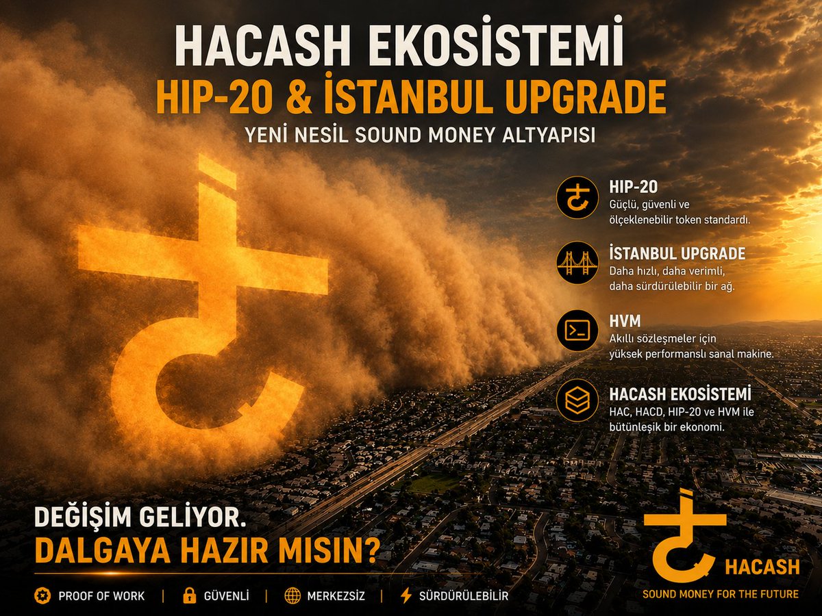
🌪️ Toz kalktığında geriye sadece güçlü temeller kalır.
Hacash ekosistemi; 🔸 HIP-20 🔸 HVM 🔸 One-Way BTC Transfer 🔸 İstanbul Upgrade
Hepsi tek bir hedef için: Yeni nesil Sound Money altyapısını inşa etmek.
Değişim sessiz başlar... Sonra herkes fark eder.
#Hacash #HIP20 #HVM #IstanbulUpgrade #Bitcoin #SoundMoney #btc #binance #SolanaMemes


🧵 3/4
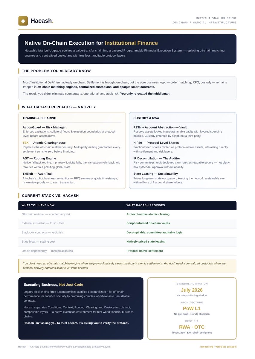
Moreover, Hacash is not just remaining a value transfer chain; it is undergoing a massive evolution! 🚀
👉 The grand Istanbul Upgrade (activating at block height 765,432 on July 19) marks a historic turning point for the network! 🗓️
🛠️ With the implementation of #HVM, ActionGuard, and TxBlob, the network gains full programmability without sacrificing security and privacy. The transition from a transfer chain to a globally programmable financial system begins! 🌐 @YouKenTrust @hacdlabs @GracyBitget


HIIII this is the trailer for the Gooning to the "Marvel Rivals universe REMAKE" ive been working on for sometime the runtime is 25, mins i will be uploading it onto the rule34video website soon hope yall enjoy ittt. #gooning #hvm #rule34 #marvelrivals #marvelrivalsedit

@HTX_Global @HTX_India Strong typing in a contract VM sounds dull until you count how many EVM hacks were type confusion. #HVM
Last Seen Hashtags on Sotwe
fitmom
Seen from Turkey
ShesAllThat
Seen from Ukraine
แนวครอบครัวแม่ลูก
Seen from Thailand
lontehijab
Seen from Indonesia
sakso
Seen from Turkey
ayakfetişi
Seen from Turkey
藤条
Seen from Germany
minichat(((((((((((((()))))))))))))) +filter:native_video
Seen from Australia
minichat()*******************
Seen from Spain
ngintip
Most Popular Users

Elon Musk 
@elonmusk
241.7M followers

Barack Obama
@barackobama
119M followers

Cristiano Ronaldo
@cristiano
114.6M followers

Donald J. Trump
@realdonaldtrump
111.9M followers

Narendra Modi
@narendramodi
107.2M followers

Rihanna
@rihanna
98.7M followers

NASA
@nasa
92.4M followers

Justin Bieber
@justinbieber
91.8M followers

KATY PERRY
@katyperry
90.1M followers

Taylor Swift
@taylorswift13
84M followers

Lady Gaga
@ladygaga
75.5M followers

Virat Kohli
@imvkohli
73.5M followers

Kim Kardashian
@kimkardashian
70.9M followers

YouTube
@youtube
68.8M followers

Neymar Jr
@neymarjr
66.5M followers

Bill Gates
@billgates
65.2M followers

Selena Gomez
@selenagomez
63.1M followers

The Ellen Show
@theellenshow
62.3M followers

CNN
@cnn
61.8M followers

X
@x
60.7M followers