

Top Tweets for #Qldstorm

#tropicswx #QLDStorm #PNGwx |
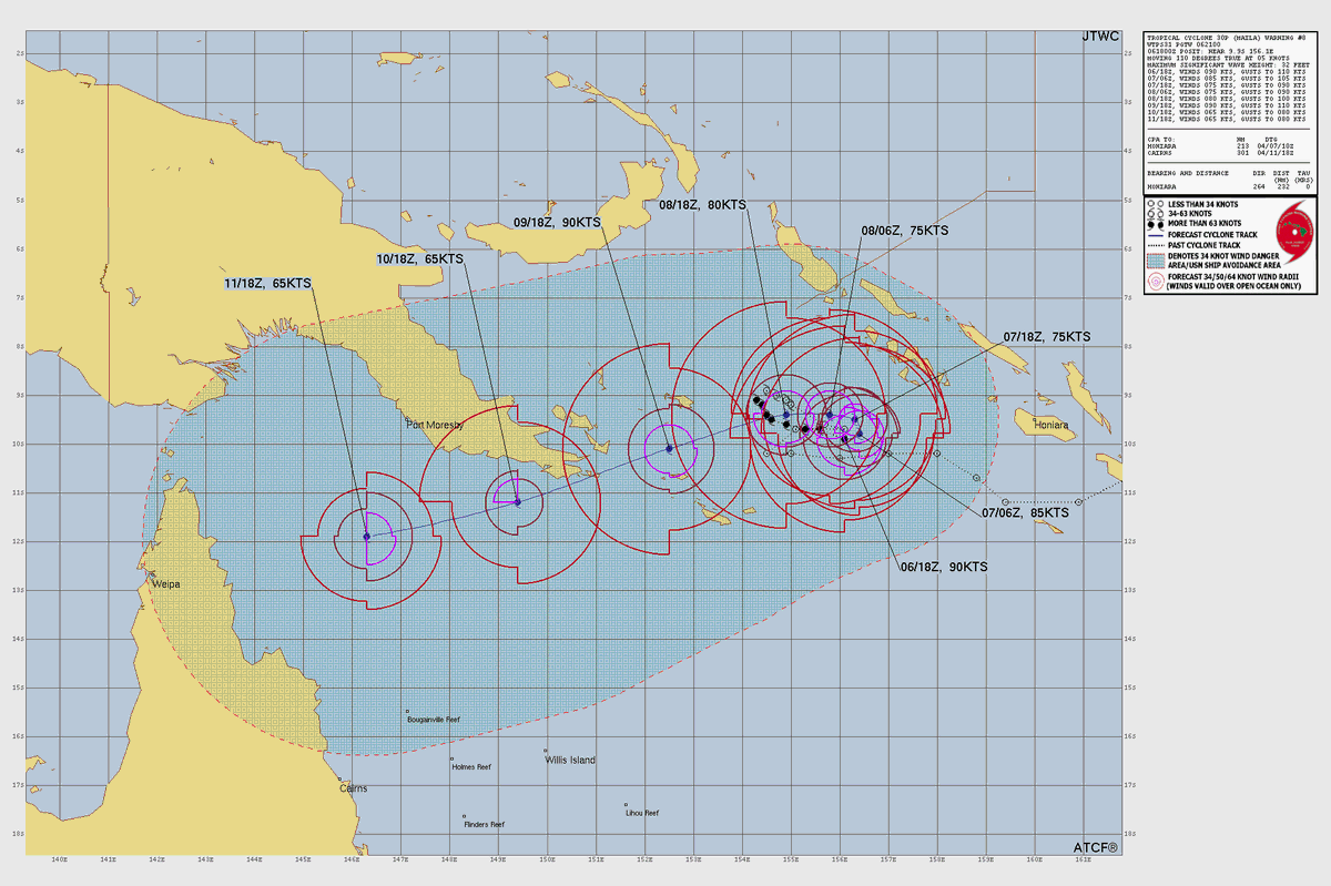
#Maila is still hanging around the Solomon Sea & has recently became the strongest TC in the sea on record. Maila likely to hit #PapuaNewGuinea on the Papuan Peninsula as a C1 cyclone (SSHWS) before moving towards the Coral Sea where #Queensland needs to take interest.
#tropicswx #QLDStorm |
Cyclone #Narelle made landfall near Lockhart River, #Queensland, becoming the strongest landfalling TC in the state since Yasi '11. Narelle will make a brief journey through the Cape York Pennisula before going into the Gulf of Carp. & striking #NorthernTerritory.
Destructive winds are now hitting the N #Queensland coast as #Narelle’s eye moves ashore near Lockhart River. We’re watching a band crossing Weipa where some embedded supercells could spawn tornadoes.
#QLDStorm #tropicswx #severewx
#Narelle reached its peak at 125kts (145mph). That said, due to some E-erly shear, it doesn’t look like it’s further intensifying. That said, Narelle is expected to be 1 of the most powerful TCs #Queensland has faced since Yasi ‘11. A very dangerous storm.
#tropicswx #QLDStorm
#tropicswx #QLDStorm |
#Narelle, now at C4 status (SSHWS; C5 AUS) is about to deal a nasty blow to #Queensland. Now there is some shear which isn’t helping the eye clear too fast but it’s still making a run for it. Even when Narelle weakens near landfall, it will still be a powerful TC.
Those in N QLD can expect intense winds, high storm surge, inland flooding & even a tornado or two.

#tropicswx #QLDStorm |
#Narelle is at C3 (SSHWS) status & is now making a beeline towards the #Queensland coast. The eye has appeared w/ heavy convection surrounding it. Narelle is enjoying the expansive outflow which is helping it to breathe more. We have a little under 30hrs until landfall.
#tropicswx #QLDStorm |
#Narelle may legitimately become one of the strongest landfalling TCs in #Queensland in many years. Narelle is nearly a C1 (SSHWS) & it's prepping for rapid intensification w/ a CDO & distinct banding. Optimal SSTs & shear pattern will aid in its strengthening process. Landfall is expected within 2 days.


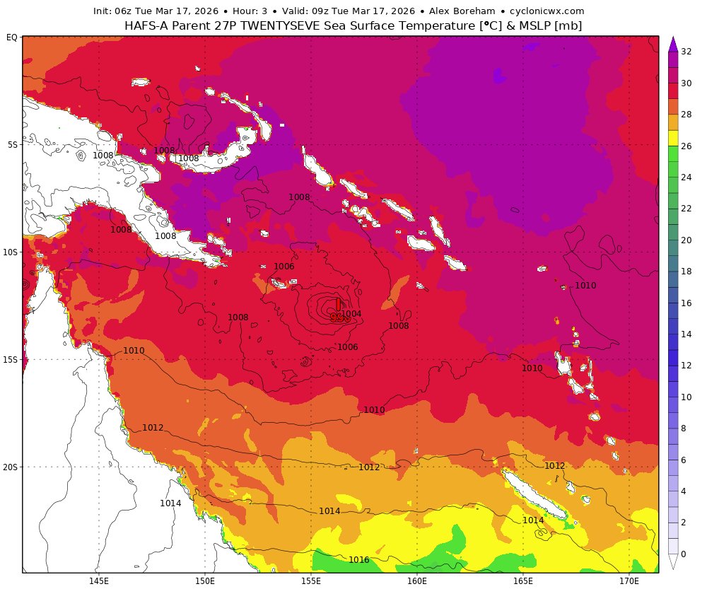
As for #Queensland, a Tropical Cyclone Watch has been issued from Lockhart River to Port Douglas. #27P could bring damaging winds, storm surge flooding, & inland flooding.
#tropicswx #QLDStorm
#tropicswx #PNGwx |
#27P is already looking a bit impressive despite it just forming. ASCAT already picked up sustained winds as high as 45kts (50mph) & some convection is making some effort in curving upshear. There's end a bit of dry air that made a bit of a banding eye, at least on vis imagery.
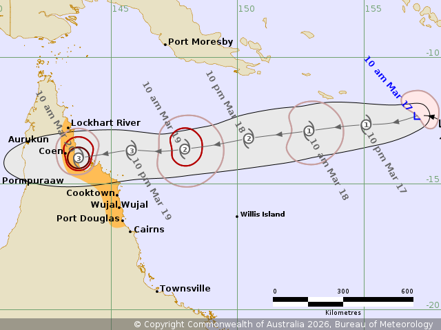
27P currently poses a danger to #MilneBay Province in #PapuaNewGuinea so this could get rather serious.

The new cone is out for #27P where it's expected to move by #MilneBay Province in #PapuaNewGuinea. Afterwards, it will be much stronger by the time it heads into #Queensland. Interest should be taken in those aforementioned places.
#QLDStorm #PNGwx #tropicswx

A tropical cyclone is developing very soon. #96P is in between #PapuaNewGuinea & #SolomonIslands. The track is in fair agreement w/ impacts to N #Australia but intensity-wise, it's still up in the air. #Narelle is the next name on the list.
#tropicswx #AUSStorm


#tropicswx #QLDStorm |
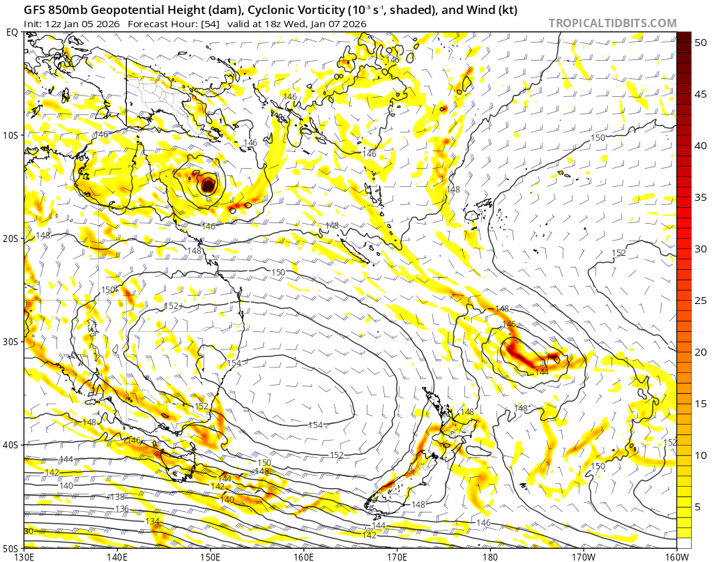
#Australia may have the 1st landfalling tropical cyclone, mainly in #Queensland. A tropical wave is hanging around N 🇦🇺 & this gyre has a bunch of mid-lvl vortices inside it. Similar to the Central American Gyre, this gyre can attempt to drill one of those mid-lvl circulations towards the surface & help spawn a tropical cyclone. This is expected to happen in roughly within 5 days.

This big ass storm cloud #QLDStorm


#QLDStorm #tropicswx |
#Alfred is closing in on the #Queensland coast after it pummels it with seemingly endless rain. Alfred has been trekking slowly, leading to flooding for parts of the Brisbane & Gold Coast metros. The landfall process is underway as the center move into Dunwich.
#QLDStorm #NSWStorm #tropicswx |
It’s rare to see a TC make landfall in the Brisbane Metro in SE #Queensland but #Alfred is managing to do that. That said, Alfred is pretty exposed w/ its circulation & due to this, it’s not expected to be any stronger than a mid range TS (SSHWS; C1-C2 AUS). That said, bands of heavy rainfall & gusty winds are expected. A TC warning has been issued for parts of QLD & #NewSouthWales.


Brisbane and the AFL are working with the Queensland government and local authorities over plans for Thursday night’s Gabba season opener.
Currently a ‘watching brief’.
300-600mm of rain + 130km/h winds forecast over Wed/Thurs as Cyclone Alfred nears
@7NewsMelbourne @7AFL

Want to join me anyone ?
It’s pitch black outside and all the homes in my area
Power company is working overtime I suppose…..
#qldstorm

Storm hit central Qld a while ago
Power out and I’m sitting in the dark with candles and luckily for me I can see the moon 🌑 now. Thank you universe
#qldstorm


Lots of lightning strikes in this storm #qldstorm
A system of storms stretching from Queensland’s southeast to the state’s central west has sparked a severe weather warning, with damaging winds and large hail possible. #qldweather #qldstorm https://t.co/bSPD0AIc5I
Trends for you
Most Popular Users

Elon Musk 
@elonmusk
241M followers

Barack Obama
@barackobama
119.2M followers

Cristiano Ronaldo
@cristiano
111.8M followers

Donald J. Trump
@realdonaldtrump
111.8M followers

Narendra Modi
@narendramodi
107M followers

Rihanna
@rihanna
98M followers

NASA
@nasa
92.2M followers

Justin Bieber
@justinbieber
91.2M followers

KATY PERRY
@katyperry
88.3M followers

Taylor Swift
@taylorswift13
82.2M followers

Lady Gaga
@ladygaga
73.7M followers

Virat Kohli
@imvkohli
71M followers

Kim Kardashian
@kimkardashian
70.1M followers

YouTube
@youtube
68.7M followers

Bill Gates
@billgates
64.3M followers

Neymar Jr
@neymarjr
63.8M followers

The Ellen Show
@theellenshow
62.4M followers

CNN
@cnn
61.8M followers

Selena Gomez
@selenagomez
61.4M followers

X
@x
60.8M followers