Top Tweets for #bcStorm


Struggling a bit between clouds, my cold, and the city lights but undeterred, an #AuroraBorealis shot at 1:12am as they light up the skies over Vancouver’s North Shore Mountains.
#ShareYourWeatner #BCStorm #BCStormWatch #AuroraWatch #NorthernLights @TamithaSkov @Vincent_Ledvina

Aurora possible tonight across the Lower Mainland if skies can clear over the next few hours. Current space weather is favourable, w/ a low Bz & strong hemispheric power. If you’re out after dark and skies clear, look N/NE. If conditions hold, you may catch a glimpse.
#BCStorm


For Saturday, temperatures over here in Vancouver for the 10am kick-off for Canada will be around 17°C (63°F) with mostly Sunny skies. May want to wear an extra layer! 🥶 #bcstorm
In Toronto at 1pm for kick-off it will be 27°C (81°F) feeling like 35°C (95°F). 🥵

Happy Canada Day from here on the West Coast. Mother Nature giving us well below average temperatures today and a slim chance of rain showers. Temperatures struggling to come close to 20°C today in Vancouver. 18°C (64°F) at 350pm here in Coquitlam. #shareyourweather #bcstorm

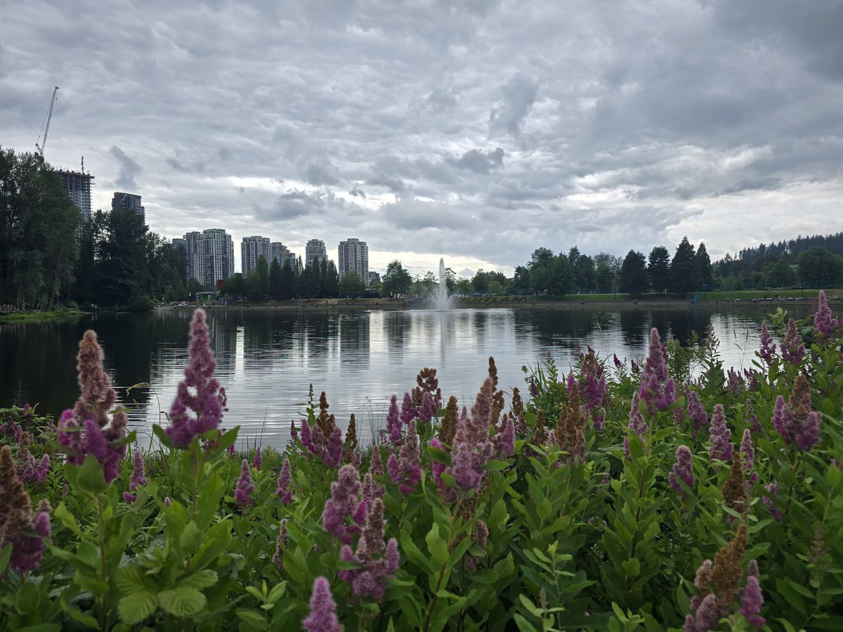

#BCStorm #BCwx #BCStormWatch
https://t.co/5galAEf0v8
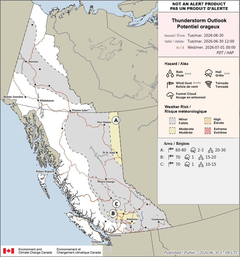
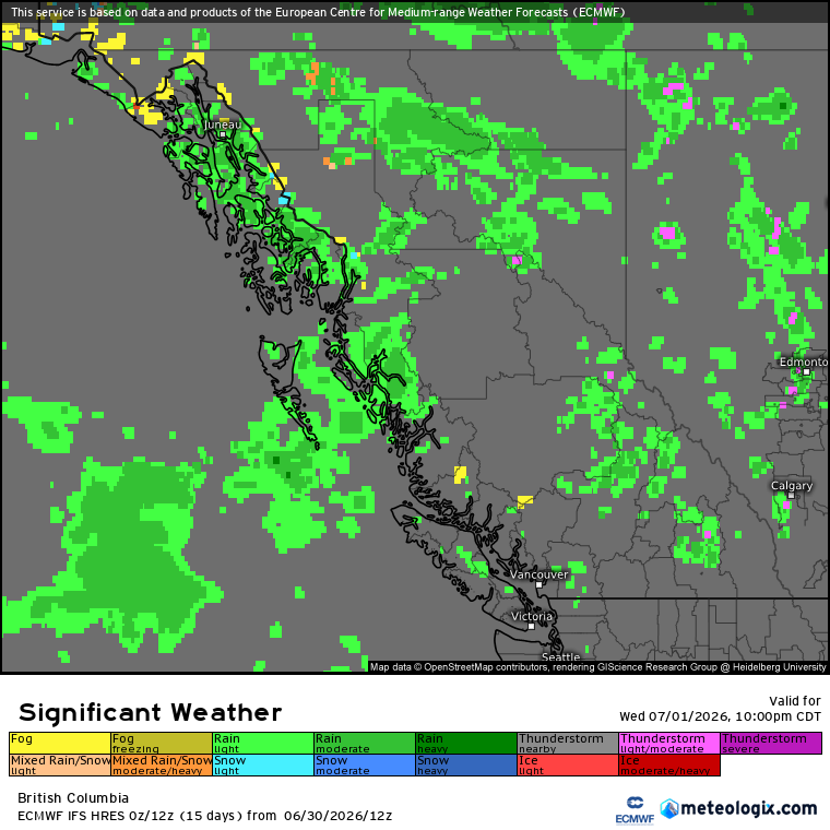
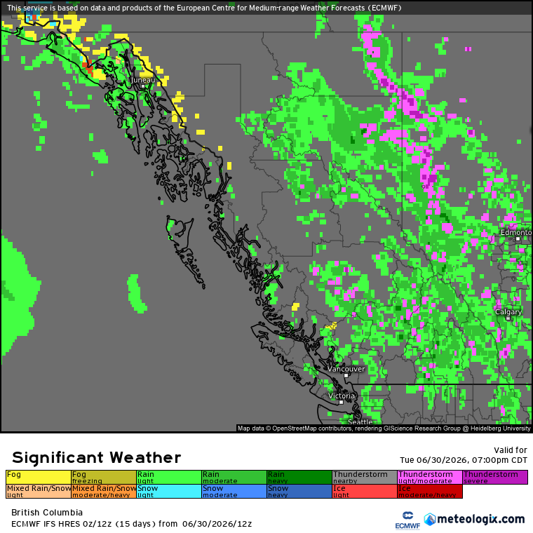
However, for many, it may be a wet &/or electric Canada Day, with rain/convection & a risk of isolated-scattered thunderstorms is still expected this afternoon-evening in the Koots-Columbias (incl. the eastern outskirts of the Okanagan region), Shuswap, Thompson, & Central Interior regions.
Heavy downpours, hail up to 0.25-0.5 inch/~0.5-1.25 cm, & wind gusts up to 50-60 km/h will be possible in convection (non-TSTM/TSTM). However, in any strong-severe cells that develop within the highlighted area, extremely heavy downpours, stronger wind gusts (up to 70-80 km/h), &/or larger hail (up to 0.75 inch/~2 cm) will be possible.


#BCStorm #BCwx #BCStormWatch
(ECCC outlook in the previous post & top two outlooks in this post are for today, personal outlook in the bottom left is for tmrw)
Thunderstorm Threat - Tomorrow
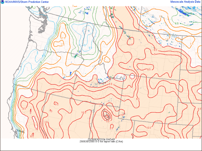
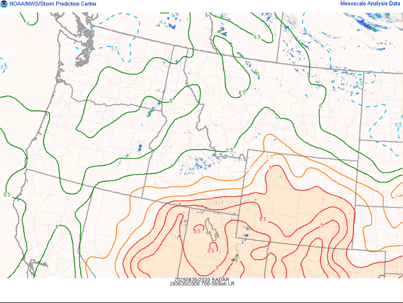
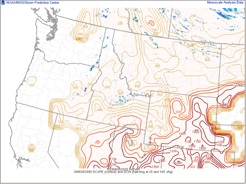
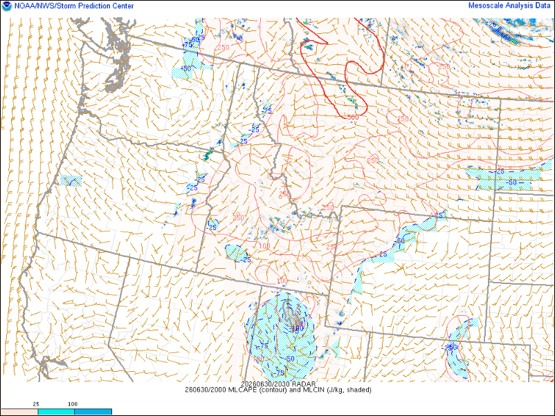
The environment will be characterized by weak instability (up to ~100-750 SBCAPE, ~100-250 MLCAPE, locally higher possible), modest deep-layer shear (~15-30 kts), steep lapse rates (7-8.5 C/km low levels, 6-7 C/km mid levels), & DCAPE values up to ~100-750 during the mid/late morning-early/mid eve period.


Happy Canada Day! 🇨🇦🇨🇦🇨🇦
Here was this morning's beautiful sunrise in #Kelowna #BC. 👌
#BCStorm #BCwx #BCStormWatch #ShareYourWeather #CanadaDay


#bcstorm
Hart highlands, Prince George BC
2045 Local
South


#BCStorm #BCwx
Winds
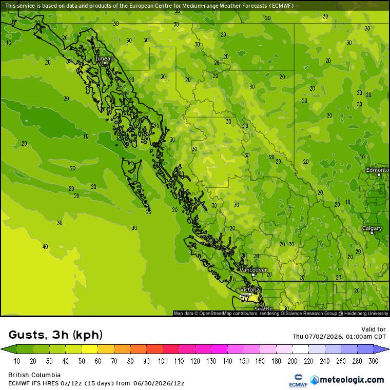
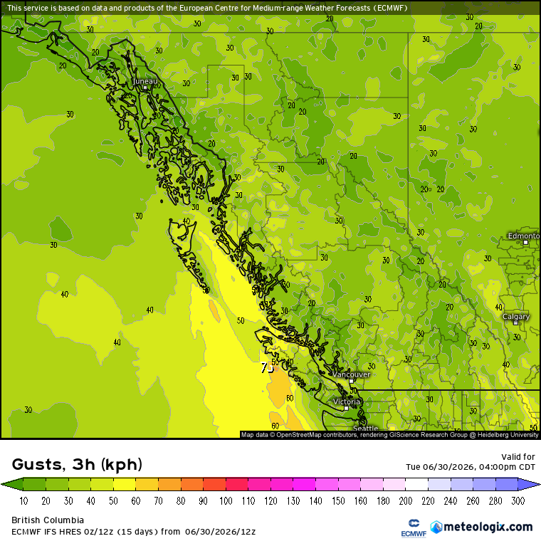
Daily (non storm-related) maximum wind gusts of up to 30-60 km/h will be expected for some-most of Southern BC today & tomorrow, w/ gusts up to 70-80 km/h possible for exposed sections of the West Island today-tonight & the Fraser Canyon/Lytton area today (this aft-eve) & tmrw (later morning-eve).
Note: For most (if not all), peak winds/wind threat will occur during the mid morning-mid eve hrs.
Notes
- Updates will be provided (as necessary) over the next couple of days.
- Refer to maps provided for further details.

#BCStorm #BCwx #BCStormWatch
Rainfall (5 am today to 5 am Thursday)
Interior: For most, <1-5 mm to up to 20-40 mm of rain is expected. Both the highest totals, & greatest possibility for locally higher totals, will tend to occur where moderate-heavy rain/convection &/or any t-storm(s) pass over (particularly continuously/repeatedly).
Coastal Regions: While not discussed, periods of showers/rain/convection will be possible for parts of the coast today, tmrw, & tmrw night. As such, for parts, a trace to up to 5-10 mm of rain will be expected.
#BCStorm #BCwx
Additional T-Storm Notes
- W/ shear expected to be on the weaker side (≤25 kts) for all today & at least most tmrw, it's expected that the majority-all of today's & tmrw's convection (non-TSTM/TSTM) will be short-lived (popcorn/pulse type; generally quick maturity before weakening, lasting no more then ~30-60 mins), which'll also tend to result in non-TSTM/TSTM collisions/interactions due to the lack of organization, additional forcing from any outflow boundaries that advance away from weakening convection, allowing for further development, & relatively slow storm motions.
- As well, today's & tmrw's storms will tend to favour the higher elevations/ridgetops (at least initial development) due to the weaker shear/steering coinciding w/ greater lift (orographic lift) & associated thermodynamic environment (ie. dry/drier lower elevations/valleys).
#BCStorm #BCwx #BCStormWatch
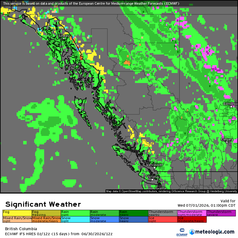
Convection (TSTM/non-TSTM) will be capable of producing heavy downpours, hail up to 0.25-0.5 inch/~0.5-1.25 cm, & wind gusts up to 50-60 km/h. However, in any strong-severe cells that develop within the highlighted area, extremely heavy downpours, stronger wind gusts (up to 70-80 km/h), &/or larger hail (up to 0.75 inch/~2 cm) will be possible.
The storm mode will be cellular (singular/multi), which includes any multi-cell clustering.
#BCStorm #BCwx
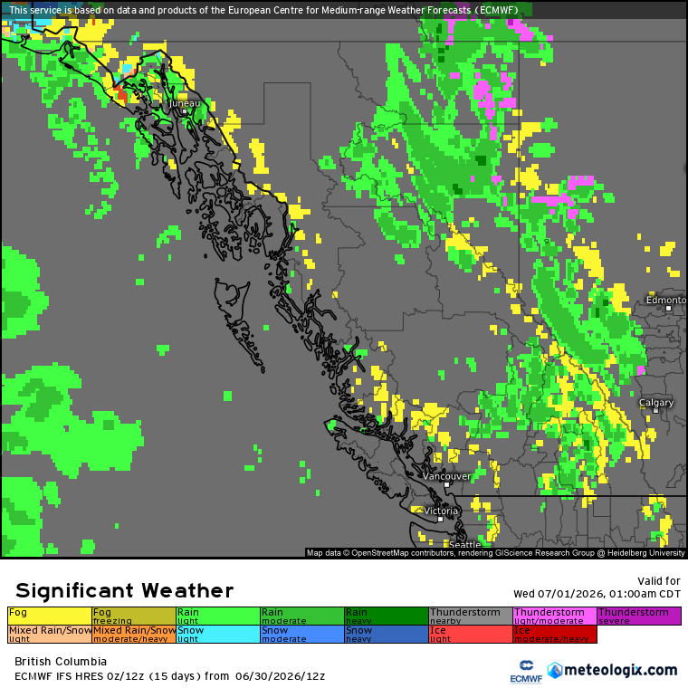
In tandem w/ daytime heating, orographic lift, & the cool upper troughing w/ related flow (+ any embedded disturbances within), this'll allow for patchy-widespread rain/convection & the risk of isolated-scattered t-storms, several in which may become strong-severe, mid or late tmrw morning to mid or late tmrw eve across the Koots-Columbias (incl. the eastern outskirts of the Okanagan region), Shuswap, (particularly North) Thompson, & Central Interior.
#BCStorm #BCwx #BCStormWatch
(ECCC outlook in the previous post & top two outlooks in this post are for today, personal outlook in the bottom left is for tmrw)
Thunderstorm Threat - Tomorrow
The environment will be characterized by weak instability (up to ~100-750 SBCAPE, ~100-250 MLCAPE, locally higher possible), modest deep-layer shear (~15-30 kts), steep lapse rates (7-8.5 C/km low levels, 6-7 C/km mid levels), & DCAPE values up to ~100-750 during the mid/late morning-early/mid eve period.
#BCStorm #BCwx #BCStormWatch
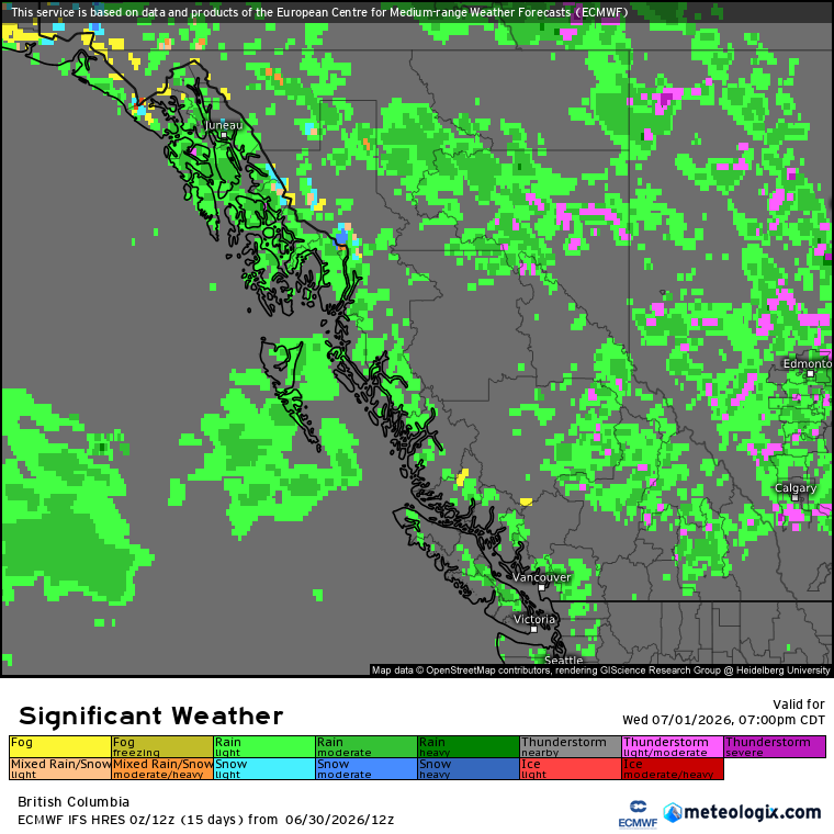
Convection (TSTM/non-TSTM) will remain capable of producing heavy to extremely heavy downpours, hail up to 0.25-0.5 inch/~0.5-1.25 cm, & wind gusts up to 50-70 km/h through the rest of this aft to mid or late eve. However, in any strong-severe cells that develop within the highlighted area (*not limited to the severe thunderstorm watch*), stronger wind gusts (up to 80-90 km/h) &/or larger hail (up to 0.75-1 inch/~2-2.5 cm) will be possible.
The storm mode will be cellular (singular/multi), which includes any multi-cell clustering.


#BCStorm #BCwx
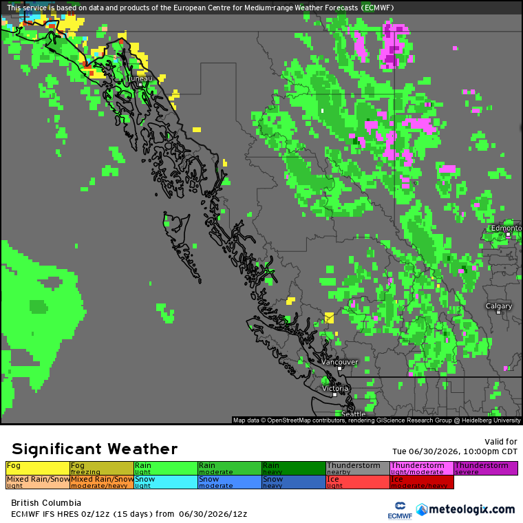
In tandem w/ daytime heating, orographic lift, & the cool upper troughing + low w/ related flow (+ any embedded disturbances within), this'll allow for patchy-widespread rain/convection & the risk of isolated-scattered t-storms, several in which may become strong-severe, to CONTINUE through this aft to mid or late eve across the Interior, with a severe thunderstorm watch currently in place for the Central-North Okanagan, Nicola, South Thompson, & North Fraser Canyon!
However, a few isolated t-storms will remain possible in the Koots-Columbias, Shuswap, North Thompson, & Central Interior through the rest of tonight to early or mid tmrw morning.

#BCStorm #BCwx #BCStormWatch
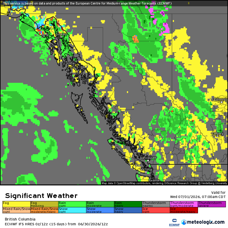
Thunderstorm Threat - Present to Tonight
Looking at the environment, it'll be characterized by marginal instability (~100-1250 SBCAPE, ~100-500 MLCAPE), weak deep-layer shear (≤25 kts), steep lapse rates (7-8.5 C/km low levels; steeper possible in the Central Interior, 6-7 C/km mid levels), & DCAPE values up to ~100-1000 during the aft-early/mid eve hrs.
Last Seen Hashtags on Sotwe
Most Popular Users

Elon Musk 
@elonmusk
240.7M followers

Barack Obama
@barackobama
119.2M followers

Donald J. Trump
@realdonaldtrump
111.7M followers

Cristiano Ronaldo
@cristiano
110.8M followers

Narendra Modi
@narendramodi
107M followers

Rihanna
@rihanna
97.7M followers

NASA
@nasa
92.2M followers

Justin Bieber
@justinbieber
90.9M followers

KATY PERRY
@katyperry
87.8M followers

Taylor Swift
@taylorswift13
81.6M followers

Lady Gaga
@ladygaga
73.2M followers

Virat Kohli
@imvkohli
70.1M followers

Kim Kardashian
@kimkardashian
69.8M followers

YouTube
@youtube
68.7M followers

Bill Gates
@billgates
64M followers

Neymar Jr
@neymarjr
62.9M followers

The Ellen Show
@theellenshow
62.4M followers

CNN
@cnn
61.9M followers

Selena Gomez
@selenagomez
60.9M followers

X
@x
60.8M followers