Top Tweets for #spatialAnalysis

What is an Image Composite? | Google Earth Engine & Remote Sensing Explained.
#googleearthengine
#remotesensing
#GIS
#Sentinel2
#LANDSAT
#EarthObservation
#satelliteimagery
#Geospatial
#SpatialAnalysis

Every final score traces back to its root components, allowing decision-makers to know exactly why a location is viable.
Watch the full data-driven workflow below. 👇
https://t.co/Z81Tjp9Qt4
#UrbanPlanning #Geospatial #SiteSelection #GeoAI #SpatialAnalysis #GriidAi

GIS in Land Resource Management and Administration Training. Register now at https://t.co/DIbsNaaRIT
#gis #landmanagement #geospatial #corporatetraining #professionaldevelopment #spatialanalysis #gistraining #solomonpeoplesolutions #solomonenables


"Agent-Based Modeling and Geographical Information Systems: A Practical Primer (GeoSpatial Analytics and GIS)" https://t.co/y1DsK8B1w1
—————
#DataScience #AI #ComputationalScience #SocialScience #NetworkScience #SpatialAnalysis #Simulation

Natural-color and false-color band combination in Google Earth Engine.
To get full tutorial comment #remotesensing
#googleearthengine
#remotesensing
#GIS
#GeoAI
#geospatial
#ArcGISPro
#QGIS
#PythonGIS
#EarthObservation
#satelliteimagery
#machinelearning
#SpatialAnalysis


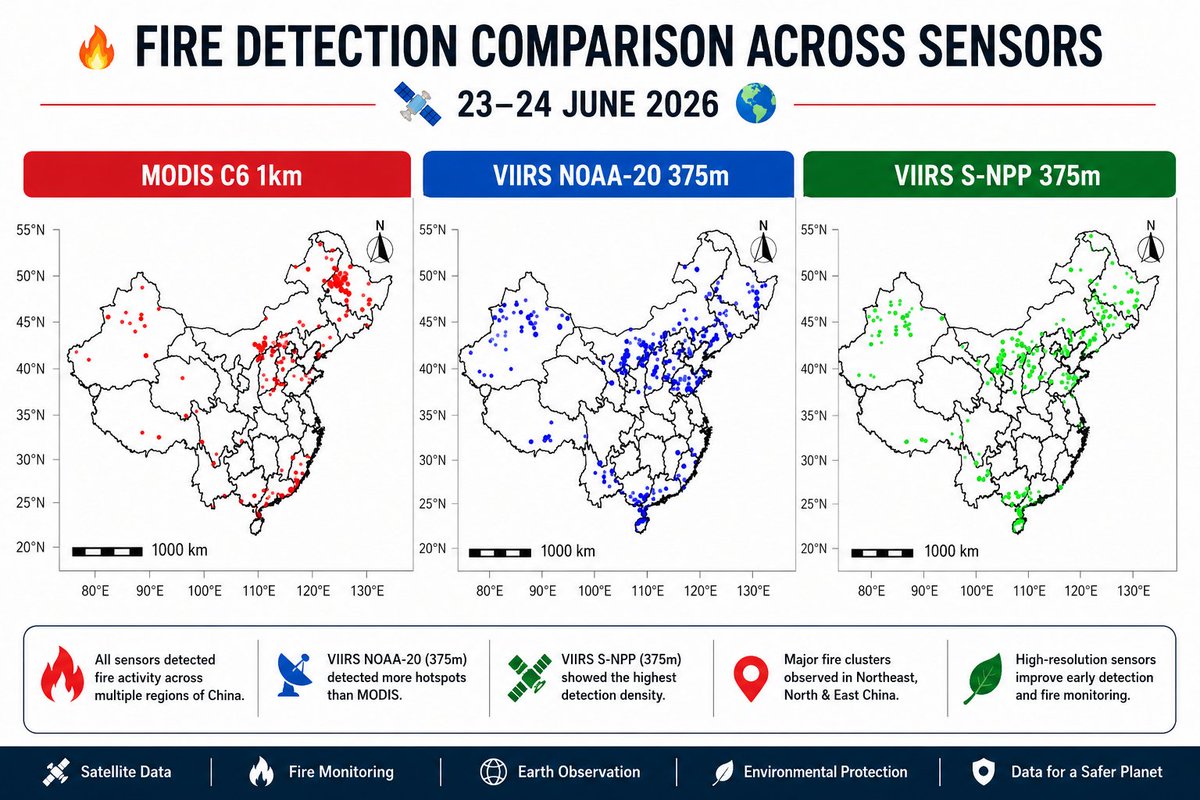
🔥 Fire Detection Comparison Across Sensors in South Asia (22–23 June 2026) 🌏🛰️
#RemoteSensing #GIS #MODIS #VIIRS #FireDetection #SouthAsia #WildfireMonitoring #EarthObservation #SatelliteData #GeospatialAnalysis #ClimateChange #EnvironmentalMonitoring #SpatialAnalysis

Meet #DrFincher 🎓💜✨
The #TarletonCJ family couldn't be more proud. Congratulations, Dr. Fincher — welcome to the other side! 🥳💪
#TexansByTradition #DissertationDefense #TarletonState #TexanPride #PhDLife #CJResearch #ChildProtection #SpatialAnalysis #MajorAchievement

🔥 Fire Detection Comparison Across Sensors in South Asia (22–23 June 2026) 📷
#SouthAsia #wilsdire #consultant #EarthObservation #SatelliteData #GeospatialAnalysis #ClimateChange #EnvironmentalMonitoring #SpatialAnalysis #DataScience 📷📷📷📷 🌍📊🌿🚨

🔥 Fire Detection Comparison Across Sensors in South Asia (22–23 June 2026) 🌏🛰️
#SouthAsia #wilsdire #consultant #EarthObservation #SatelliteData #GeospatialAnalysis #ClimateChange #EnvironmentalMonitoring #SpatialAnalysis #DataScience 🔥🛰️🌍📊🌿🚨


Can you predict where people are most likely to run?
With QGIS + sDNA, you can analyze street networks using Betweenness Centrality to identify corridors that naturally attract pedestrian movement.
A powerful tool for smarter urban planning.
#QGIS #GIS #sDNA #SpatialAnalysis

📷 Fire Detection Comparison Across Sensors in East Africa (20–22 June 2026) 📷📷
#EastAfrica #EarthObservation #SatelliteData #GeospatialAnalysis #ClimateChange #EnvironmentalMonitoring #SpatialAnalysis #DataScience 🔥🛰️🌍📊🌿🚨


ماهو ArcGIS؟
ليست مجرد خرائط، بل هو نظام شامل لإنشاء البيانات وإدارتها وتحليلها.
لمعرفة المزيد: https://t.co/9YREoQCwfa
#ArcGISPro #GIS #Mapping #SpatialAnalysis #DataManagement #Imagery #Esri
🏆✨ Uncovering hidden opportunities beneath the surface!
Tutorial link: https://t.co/3ao6dlKb3f
#GoldExploration #MineralPotentialMapping #GIS #RemoteSensing #Mining #Geology #GeoAI #SpatialAnalysis #EarthObservation

🔥 Active Fire Detections Across North America (15–19 June 2026) 🌎🛰️
#RemoteSensing #GIS #FireMonitoring #Wildfire #SatelliteData #EarthObservation #NorthAmerica #ClimateChange #EnvironmentalMonitoring #GeospatialAnalysis #VIIRS #MODIS #SpatialAnalysis 🔥🛰️🌎📊🌲🚨

🛰️ Mapping Ferric Iron (Fe³⁺) from Space!
Check details:
https://t.co/rd5mPpINVa
#RemoteSensing #MineralExploration #ASTER #GIS #Geology #Mining #Geospatial #EarthObservation #MineralMapping #SatelliteData #Fe3 #HydrothermalAlteration #SpatialAnalysis #Geoscience


🚨 NEW COURSE
QGIS: An Introduction to Geographic Information Systems (GIS)
📅 July 14th, 16th, 17th, 20th, and 22nd, 2026
🌐 Online format
Info: https://t.co/mREppn8bdW
#QGIS #GIS #SpatialAnalysis


Exploring Kenya’s population distribution.
This population density map, created from the Global Human Settlement Population Grid (GHS-POP) dataset, visualizes population counts per 100-meter grid cell across Kenya.
#GIS #Geospatial #QGIS #DataVisualization #SpatialAnalysis #Kenya

How to Publish Google Earth Engine Apps | Complete GEE Web App Tutorial. Tutorial link: https://t.co/5A4xGCQMHx
#WebGIS
#GIS
#remotesensing
#geospatial
#EarthObservation
#GeoAI
#SpatialAnalysis
#appdevelopment
#mapping
Using the Esri 10 m Land Cover dataset and DEM data from USGS EarthExplorer, I processed and analyzed the data and area statistics in QGIS, with tables and charts prepared in Microsoft Excel.
#GIS#RemoteSensing. #Geospatial #LandCover #DataAnalysis #Cartography #SpatialAnalysis

Last Seen Hashtags on Sotwe
Seksiolgun
Seen from Turkey
nolimit()******************* +filter:native_video
Seen from France
Dummy
Seen from United Kingdom
poojahegde ai videos
Seen from India
Omegle
Seen from Netherlands
grepe
Seen from Indonesia
hijab bbc
Seen from France
青旅
Seen from Germany
acnoctem
Seen from Turkey
Benybbc
Seen from Canada
Most Popular Users

Elon Musk 
@elonmusk
240.6M followers

Barack Obama
@barackobama
119.2M followers

Donald J. Trump
@realdonaldtrump
111.7M followers

Cristiano Ronaldo
@cristiano
110.5M followers

Narendra Modi
@narendramodi
107M followers

Rihanna
@rihanna
97.6M followers

NASA
@nasa
92.2M followers

Justin Bieber
@justinbieber
90.9M followers

KATY PERRY
@katyperry
87.6M followers

Taylor Swift
@taylorswift13
81.4M followers

Lady Gaga
@ladygaga
73M followers

Virat Kohli
@imvkohli
69.8M followers

Kim Kardashian
@kimkardashian
69.8M followers

YouTube
@youtube
68.7M followers

Bill Gates
@billgates
63.9M followers

Neymar Jr
@neymarjr
62.5M followers

The Ellen Show
@theellenshow
62.4M followers

CNN
@cnn
61.9M followers

X
@x
60.8M followers

Selena Gomez
@selenagomez
60.7M followers