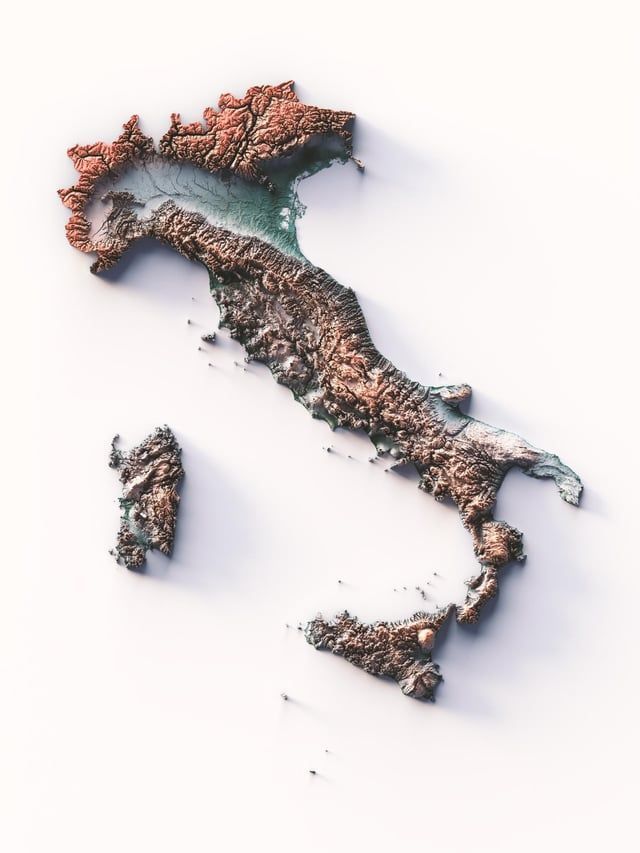
This is the second version of the map shared days ago, this time we made it without bathymetry and the final effect is quite different. Which one do you prefer?
#cARTography#map#italy#gis#dataviz#shadedrelief
Service announcement: we are forced to disable access to https://t.co/LUdunOX0Xt from Hong Kong because of bots. If you are from there and legit, reach us. We are sorry for that
Service announcement: we are forced to disable access to https://t.co/LUdunOX0Xt from Hong Kong because of bots. If you are from there and legit, reach us. We are sorry for that
Map of the Balkans, centred on Albania, the country that gives its name to the entire map.
This map is taken from ‘The World Atlas’ produced and published by the cartographic administration of the Soviet Union in 1967.
🔹Base map credit: @rumseymapcenter
Kristiana was the old name od Oslo, used since the 1924, when parliament decided to restore the original medieval name.
Map info:
Kristiania amt nr 77: Kart over Kristiania.
Amtskartsamling, Oslo 1901.Norsk Lithgr. officin, Oppmaalingsvæsenet i Kristiania
Source: kartverket.
@andreafontanot@Behance Milan Central Station is shown on the map because, at the time the project was launched, it was still under construction. It was inaugurated in 1931.
There is no mistaking the date of that map, as it is printed on the map itself.
This is the second version of the map shared days ago, this time we made it without bathymetry and the final effect is quite different. Which one do you prefer?
#cARTography#map#italy#gis#dataviz#shadedrelief
@andreamatranga Thank you!
The equalisation applied to the entire portion of Italy evens out the grey steps of the DEM, making the low points more evident.
I love this exaggerated relief map of Italy because it emphasizes the role of the Po Valley so beautifully. It's Italy's most important industrial and agricultural area and an important reason Northern Italy is much richer than Southern Italy. Source: https://t.co/6yucxhV6sv
🗺️ 𝗠𝗔𝗣 𝗜𝗡𝗙𝗢
Africa orientale Italiana, impero d'Etiopia, Eritrea e Somalia Italiana. Eastern Africa. Prepared and published by Istituto Geografico De Agostini (Novara) in 1937.
Source: UWM Library.
https://t.co/oVQU7F3DDF
Did you remember of the upcoming map of Pescara? Finally we can announce that it's finished and available at Vizcart shop!
Meanwhile we'll share with you the final result!
#abruzzo#pescara