Tropical Weather Outlook
NWS National Hurricane Center Miami FL
800 AM EDT Mon Jun 22 2026
For the North Atlantic...Caribbean Sea and the Gulf of America:
Tropical cyclone formation is not expected during the next 7 days.
$$
Forecaster Blake
#WeatherReadyNation#WRN#SKYWARN #CANWARN #Hamradio #AmateurRadio #SATERN #HurricaneHams
Tropical Weather Outlook
NWS National Hurricane Center Miami FL
800 PM EDT Sun Jun 21 2026
For the North Atlantic...Caribbean Sea and the Gulf of America:
Tropical cyclone formation is not expected during the next 7 days.
$$
Forecaster Cangialosi
#WeatherReadyNation#WRN #SKYWARN #CANWARN #Hamradio #AmateurRadio #SATERN #HurricaneHams
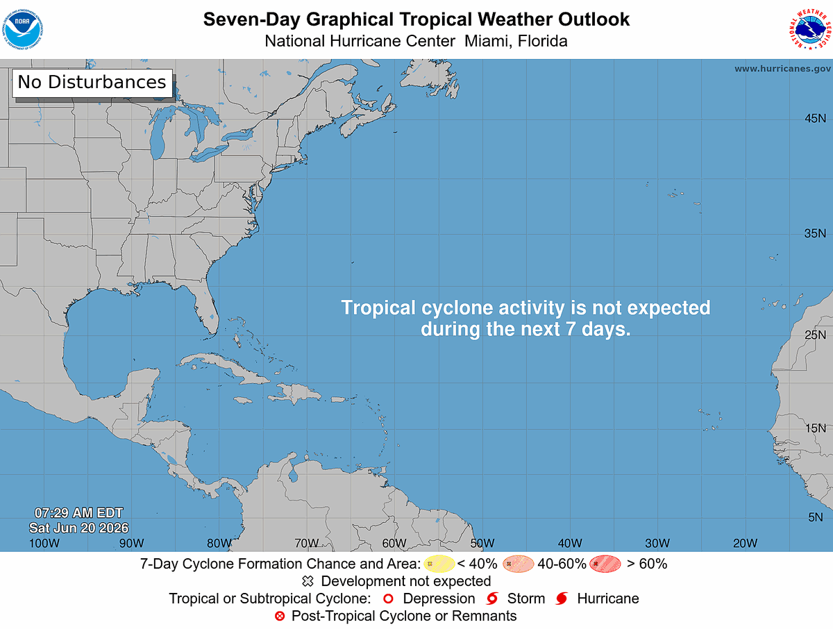
Tropical Weather Outlook
NWS National Hurricane Center Miami FL
800 AM EDT Sat Jun 20 2026
For the North Atlantic...Caribbean Sea and the Gulf of America:
Tropical cyclone formation is not expected during the next 7 days.
$$
Forecaster Blake
#WeatherReadyNation#WRN#SKYWARN #CANWARN #Hamradio #AmateurRadio #SATERN #HurricaneHams
Tropical Weather Outlook
NWS National Hurricane Center Miami FL
800 AM EDT Fri Jun 19 2026
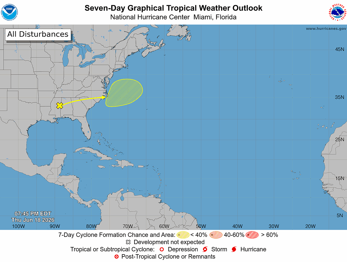
For the North Atlantic...Caribbean Sea and the Gulf of America:
1. Offshore the East Coast of the United States (Remnants of Arthur):
Showers and thunderstorms associated with a trough of low pressure
(the remnants of Arthur) are located over the southeastern United
States. The system is expected to emerge offshore the east coast of
the United States later today. Environmental conditions appear to be
marginally conducive for some subtropical or tropical development
tonight or Saturday as the system moves northeastward at around 20
mph across the Western Atlantic Ocean.
Regardless of development, heavy rainfall with the potential for
life-threatening flash flooding is likely across portions of the
Southeast United States through tonight. Additional information on
the rainfall potential can be found in rainfall forecasts and
Excessive Rainfall Outlooks from the Weather Prediction Center
online at https://t.co/4yP5smI9QG. More information on this system,
including Gale Warnings, is available in High Seas Forecasts issued
by the National Weather Service under AWIPS header NFDHSFAT1, WMO
header FZNT01 KWBC, and online at
https://t.co/mEM88spNO5
Formation chance through 48 hours...low...10 percent.
Formation chance through 7 days...low...10 percent.
Forecaster Reinhart
#WeatherReadyNation #WRN #SKYWARN #CANWARN #Hamradio #AmateurRadio #SATERN #HurricaneHams
Tropical Weather Outlook
NWS National Hurricane Center Miami FL
800 PM EDT Thu Jun 18 2026
For the North Atlantic...Caribbean Sea and the Gulf of America:
Offshore the East Coast of the United States (Remnants of Arthur):
Showers and thunderstorms associated with a trough of low pressure
(the remnants of Arthur) are located over the southeastern United
States. The system is expected to emerge offshore the east coast of
the United States on Friday. Environmental conditions then appear to
be marginally conducive for some subtropical or tropical development
on Friday or Saturday as the system moves northeastward at 15 to 20
mph across the Western Atlantic Ocean.
Regardless of development, heavy rainfall with the potential for
widespread and life-threatening flash flooding is likely across
portions of the Southeast United States during the next day or two.
Additional information on the rainfall potential can be found in
rainfall forecasts and Excessive Rainfall Outlooks from the Weather
Prediction Center online at https://t.co/4yP5smIHGe. More information
on this system, including Gale Warnings, is available in High Seas
Forecasts issued by the National Weather Service under AWIPS header
NFDHSFAT1, WMO header FZNT01 KWBC, and online at
https://t.co/mEM88sqlDD
Formation chance through 48 hours...low...10 percent.
Formation chance through 7 days...low...10 percent.
$$
Forecaster Beven
#WeatherReadyNation #WRN #SKYWARN #CANWARN #Hamradio #AmateurRadio #SATERN #HurricaneHams
BULLETIN
Post-Tropical Cyclone Arthur Advisory Number 8
NWS National Hurricane Center Miami FL AL012026
1000 PM CDT Wed Jun 17 2026
...ARTHUR DEGENERATES TO A LOW PRESSURE AREA ALONG THE UPPER
TEXAS COAST...
...LIFE-THREATENING FLOODING EXPECTED TO CONTINUE ACROSS PORTIONS
OF THE SOUTHEASTERN UNITED STATES...
SUMMARY OF 1000 PM CDT...0300 UTC...INFORMATION
-----------------------------------------------
LOCATION...29.7N 94.5W
ABOUT 35 MI...55 KM NNE OF GALVESTON TEXAS
ABOUT 85 MI...135 KM WSW OF LAKE CHARLES LOUISIANA
MAXIMUM SUSTAINED WINDS...35 MPH...55 KM/H
PRESENT MOVEMENT...NE OR 40 DEGREES AT 9 MPH...15 KM/H
MINIMUM CENTRAL PRESSURE...1000 MB...29.53 INCHES
WATCHES AND WARNINGS
--------------------
CHANGES WITH THIS ADVISORY:
All coastal watches and warnings are discontinued.
SUMMARY OF WATCHES AND WARNINGS IN EFFECT:
None.
DISCUSSION AND OUTLOOK
----------------------
At 1000 PM CDT (0300 UTC), the center of Post-Tropical Cyclone
Arthur was located near latitude 29.7 North, longitude 94.5 West.
The post-tropical cyclone is moving toward the northeast near 9 mph
(15 km/h). A northeastward motion at a faster forward speed is
expected tonight, followed by a turn toward the east-northeast
Thursday through Friday. On the forecast track, the remnants of
Arthur should move farther inland over southeastern Texas and
western Louisiana tonight, then cross the southeastern United States
Thursday through Friday.
Maximum sustained winds are near 35 mph (55 km/h) with higher gusts.
While additional weakening is expected as the system moves inland,
the remnants of Arthur will continue to produce widespread heavy
rains across the southeastern United States during the next few
days.
The estimated minimum central pressure based on surface observations
is 1000 mb (29.53 inches).
HAZARDS AFFECTING LAND
----------------------
Key messages for remnants of Arthur can be found in the Tropical
Cyclone Discussion under AWIPS header MIATCDAT1 and WMO header
WTNT41 KNHC.
RAINFALL: Arthur is expected to produce rainfall totals of 5 to 10
inches, with isolated higher totals near 20 inches, through early
Friday from the Mid and Upper Texas coast east-northeast into
southern and central portions of Louisiana, Mississippi, and
Alabama, along with western portions of Georgia and the Florida
Panhandle. This could generate dangerous to life-threatening flash
flooding.
For a complete depiction of forecast rainfall associated with the
remnants of Arthur, please see the National Weather Service Storm
Total Rainfall Graphic available at
https://t.co/ZQpREEfdnD and the Flash Flood Risk
graphic at https://t.co/9JDyHh5SOG.
For a list of rainfall observations (and wind reports) associated
with Arthur, see the companion storm summary at WBCSCCNS1 with the
WMO header ACUS44 KWBC or at the following link:
https://t.co/ZSYo0EdqdR.
WIND: Winds gusts to tropical-storm force are possible along the
Louisiana coast tonight.
STORM SURGE: Water levels remain elevated along the Upper Texas
coast but will continue to subside overnight.
SURF: Swells generated by Arthur are likely to cause
life-threatening surf and rip current conditions along the
northwestern Gulf Coast for the next day or two. Please consult
products from your local weather office.
A depiction of rip current risk for the United States can be found
at: https://t.co/vmRzAvl6fT
TORNADO: A few tornadoes are possible tonight across southeast
Louisiana and southern Mississippi, and tomorrow into parts of
Alabama, Georgia, and the Florida Panhandle.
NEXT ADVISORY
-------------
This is the last public advisory issued by the National Hurricane
Center on this system.
$$
Forecaster Beven
#WeatherReadyNation #WRN #SKYWARN #CANWARN #Hamradio #AmateurRadio #SATERN #HurricaneHams #TXwx #LAwx #MSwx
BULLETIN
Tropical Storm Arthur Intermediate Advisory Number 7A
NWS National Hurricane Center Miami FL AL012026
700 PM CDT Wed Jun 17 2026
...CENTER OF ARTHUR RE-FORMS NORTHEASTWARD NEAR GALVESTON TEXAS...
...LIFE-THREATENING FLOODING EXPECTED ACROSS PORTIONS OF THE
SOUTHEASTERN UNITED STATES...
SUMMARY OF 700 PM CDT...0000 UTC...INFORMATION
----------------------------------------------
LOCATION...29.4N 94.9W
ABOUT 10 MI...15 KM NW OF GALVESTON TEXAS
ABOUT 115 MI...180 KM WSW OF LAKE CHARLES LOUISIANA
MAXIMUM SUSTAINED WINDS...40 MPH...65 KM/H
PRESENT MOVEMENT...NE OR 35 DEGREES AT 8 MPH...13 KM/H
MINIMUM CENTRAL PRESSURE...1000 MB...29.53 INCHES
WATCHES AND WARNINGS
--------------------
CHANGES WITH THIS ADVISORY:
The Tropical Storm Warning is discontinued west of High Island,
Texas.
SUMMARY OF WATCHES AND WARNINGS IN EFFECT:
A Tropical Storm Warning is in effect for...
* High Island, Texas to Morgan City, Louisiana
A Tropical Storm Warning means that tropical storm conditions are
expected within the warning area.
For storm information specific to your area, including possible
inland watches and warnings, please monitor products issued by your
local National Weather Service forecast office.
DISCUSSION AND OUTLOOK
----------------------
At 700 PM CDT (0000 UTC), the center of Tropical Storm Arthur was
located near latitude 29.4 North, longitude 94.9 West. Arthur is
moving erratically toward the northeast near 8 mph (13 km/h). A
northeastward to north-northeastward motion should continue through
tonight. On the forecast track, the center of Arthur should move
farther inland over southeastern Texas tonight.
Maximum sustained winds are now near 40 mph (65 km/h) with higher
gusts. Weakening is expected as the center of Arthur moves farther
inland, and it could dissipate later tonight or early Thursday.
Tropical-storm-force winds extend outward up to 175 miles (280 km)
mainly to the southeast of the center. An oil rig well to the
southeast of the center recently reported sustained winds of 38 mph
(61 km/h) at an elevation of 135 ft (41 m).
The estimated minimum central pressure is 1000 mb (29.53 inches).
HAZARDS AFFECTING LAND
----------------------
Key messages for Tropical Storm Arthur can be found in the Tropical
Cyclone Discussion under AWIPS header MIATCDAT1 and WMO header
WTNT41 KNHC.
RAINFALL: Tropical Storm Arthur is expected to produce rainfall
totals of 5 to 10 inches, with isolated higher totals near 20
inches, through early Friday from the Mid and Upper Texas coast
east-northeast into southern and central portions of Louisiana,
Mississippi, and Alabama, along with western portions of Georgia and
the Florida Panhandle. This could generate dangerous to
life-threatening flash flooding.
For a complete depiction of forecast rainfall associated with
Tropical Storm Arthur, please see the National Weather Service Storm
Total Rainfall Graphic available at
https://t.co/ZQpREEfdnD and the Flash Flood Risk
graphic at https://t.co/9JDyHh5SOG.
For a list of rainfall observations (and wind reports) associated
with Tropical Storm Arthur, see the companion storm summary at
WBCSCCNS1 with the WMO header ACUS44 KWBC or at the following link:
https://t.co/ZSYo0EdqdR.
WIND: Tropical storm conditions are expected within the warning area
during the next few hours.
STORM SURGE: The combination of a dangerous storm surge and the
tide will cause normally dry areas near the coast to be flooded by
rising waters moving inland from the shoreline. The water could
reach the following heights above ground somewhere in the indicated
areas if the peak surge occurs at the time of high tide...
Matagorda, TX to the Mouth of the Mississippi River, LA...1-3 ft
The deepest water will occur along the immediate coast near and to
the east of the landfall location, where the surge will be
accompanied by large and dangerous waves. Surge-related flooding
depends on the relative timing of the surge and the tidal cycle,
and can vary greatly over short distances. For information
specific to your area, please see products issued by your local
National Weather Service forecast office.
For a complete depiction of areas at risk of storm surge inundation,
please see the National Weather Service Peak Storm Surge Graphic,
available at https://t.co/S5H6Qu0Ht5.
SURF: Swells generated by Arthur are likely to cause
life-threatening surf and rip current conditions along the
northwestern Gulf Coast for the next day or two. Please consult
products from your local weather office.
A depiction of rip current risk for the United States can be found
at: https://t.co/vmRzAvl6fT
TORNADO: A few tornadoes are possible late tonight across southeast
Louisiana and southern Mississippi, and tomorrow into parts of
Alabama, Georgia, and the Florida Panhandle.
NEXT ADVISORY
-------------
Next complete advisory at 1000 PM CDT.
$$
Forecaster Beven
#WeatherReadyNation #WRN #SKYWARN #CANWARN #Hamradio #AmateurRadio #SATERN #HurricaneHams #TXwx #LAwx #MSwx
BULLETIN
Tropical Storm Arthur Advisory Number 7
NWS National Hurricane Center Miami FL AL012026
400 PM CDT Wed Jun 17 2026
...LIFE-THREATENING FLOODING EXPECTED ACROSS PORTIONS OF THE
SOUTHEASTERN UNITED STATES...
...TROPICAL STORM WARNING REMAINS IN EFFECT FOR PORTIONS OF THE
TEXAS AND LOUISIANA COAST...
SUMMARY OF 400 PM CDT...2100 UTC...INFORMATION
----------------------------------------------
LOCATION...28.9N 96.1W
ABOUT 20 MI...35 KM NNW OF MATAGORDA TEXAS
ABOUT 195 MI...310 KM WSW OF LAKE CHARLES LOUISIANA
MAXIMUM SUSTAINED WINDS...45 MPH...75 KM/H
PRESENT MOVEMENT...NNE OR 15 DEGREES AT 7 MPH...11 KM/H
MINIMUM CENTRAL PRESSURE...1001 MB...29.56 INCHES
WATCHES AND WARNINGS
--------------------
CHANGES WITH THIS ADVISORY:
None.
SUMMARY OF WATCHES AND WARNINGS IN EFFECT:
A Tropical Storm Warning is in effect for...
* Sargent, Texas to Morgan City, Louisiana
A Tropical Storm Warning means that tropical storm conditions are
expected within the warning area.
For storm information specific to your area, including possible
inland watches and warnings, please monitor products issued by your
local National Weather Service forecast office.
DISCUSSION AND OUTLOOK
----------------------
At 400 PM CDT (2100 UTC), the center of Tropical Storm Arthur was
located near latitude 28.9 North, longitude 96.1 West. Arthur is
moving toward the north-northeast near 7 mph (11 km/h), and this
general motion should continue through tonight. On the forecast
track, the center of Arthur should move farther inland over
southeastern Texas tonight.
Maximum sustained winds are near 45 mph (75 km/h) with higher gusts.
Weakening is expected as the low moves farther inland, and it could
dissipate by tonight or early Thursday.
Tropical-storm-force winds extend outward up to 175 miles (280 km)
from the center. NOAA buoy 42035 east of Galveston recently reported
a sustained wind of 40 mph (65 km/h) and a gust of 52 mph (83 km/h).
The estimated minimum central pressure based on surface observations
and aircraft data is 1001 mb (29.56 inches).
HAZARDS AFFECTING LAND
----------------------
Key messages for Tropical Storm Arthur can be found in the Tropical
Cyclone Discussion under AWIPS header MIATCDAT1 and WMO header
WTNT41 KNHC.
RAINFALL: Tropical Storm Arthur is expected to produce rainfall
totals of 5 to 10 inches, with isolated higher totals near 20
inches, through early Friday from the Mid and Upper Texas coast
east-northeast into southern and central portions of Louisiana,
Mississippi, and Alabama, along with western portions of Georgia and
the Florida Panhandle. This could generate dangerous to
life-threatening flash flooding.
For a complete depiction of forecast rainfall associated with
Tropical Storm Arthur, please see the National Weather Service Storm
Total Rainfall Graphic available at
https://t.co/ZQpREEfLdb and the Flash Flood Risk
graphic at https://t.co/9JDyHh6qEe.
For a list of rainfall observations (and wind reports) associated
with Tropical Storm Arthur, see the companion storm summary at
WBCSCCNS1 with the WMO header ACUS44 KWBC or at the following link:
https://t.co/ZSYo0EdY3p.
WIND: Tropical storm conditions are expected within the warning area
during the next few hours.
STORM SURGE: The combination of a dangerous storm surge and the
tide will cause normally dry areas near the coast to be flooded by
rising waters moving inland from the shoreline. The water could
reach the following heights above ground somewhere in the indicated
areas if the peak surge occurs at the time of high tide...
Matagorda, TX to the Mouth of the Mississippi River, LA...1-3 ft
The deepest water will occur along the immediate coast near and to
the east of the landfall location, where the surge will be
accompanied by large and dangerous waves. Surge-related flooding
depends on the relative timing of the surge and the tidal cycle,
and can vary greatly over short distances. For information
specific to your area, please see products issued by your local
National Weather Service forecast office.
For a complete depiction of areas at risk of storm surge inundation,
please see the National Weather Service Peak Storm Surge Graphic,
available at https://t.co/S5H6Qu1fiD.
SURF: Swells generated by Arthur are likely to cause
life-threatening surf and rip current conditions along the
northwestern Gulf Coast for the next day or two. Please consult
products from your local weather office.
A depiction of rip current risk for the United States can be found
at: https://t.co/vmRzAvlE5r
TORNADO: A few tornadoes are possible late tonight across southeast
Louisiana and southern Mississippi, and tomorrow into parts of
Alabama, Georgia, and the Florida Panhandle.
NEXT ADVISORY
-------------
Next intermediate advisory at 700 PM CDT.
Next complete advisory at 1000 PM CDT.
$$
Forecaster Reinhart
#WeatherReadyNation #WRN #SKYWARN #CANWARN #Hamradio #AmateurRadio #SATERN #HurricaneHams #TXwx #LAwx #MSwx
BULLETIN
Tropical Storm Arthur Special Advisory Number 6
NWS National Hurricane Center Miami FL AL012026
1130 AM CDT Wed Jun 17 2026
...TROPICAL STORM WARNING EXTENDED SOUTHWARD...
...LIFE-THREATENING FLOODING EXPECTED ACROSS PORTIONS OF THE
SOUTHEASTERN UNITED STATES...
SUMMARY OF 1130 AM CDT...1630 UTC...INFORMATION
-----------------------------------------------
LOCATION...28.8N 95.5W
ABOUT 60 MI...100 KM ENE OF PORT OCONNOR TEXAS
ABOUT 165 MI...265 KM WSW OF LAKE CHARLES LOUISIANA
MAXIMUM SUSTAINED WINDS...45 MPH...75 KM/H
PRESENT MOVEMENT...NE OR 45 DEGREES AT 9 MPH...15 KM/H
MINIMUM CENTRAL PRESSURE...999 MB...29.50 INCHES
WATCHES AND WARNINGS
--------------------
CHANGES WITH THIS ADVISORY:
The Tropical Storm Warning has been extended southward to Sargent,
Texas.
SUMMARY OF WATCHES AND WARNINGS IN EFFECT:
A Tropical Storm Warning is in effect for...
* Sargent, Texas to Morgan City, Louisiana
A Tropical Storm Warning means that tropical storm conditions are
expected within the warning area.
For storm information specific to your area, including possible
inland watches and warnings, please monitor products issued by your
local National Weather Service forecast office.
DISCUSSION AND OUTLOOK
----------------------
At 1130 AM CDT (1630 UTC), the center of Tropical Storm Arthur was
located near latitude 28.8 North, longitude 95.5 West. Arthur is
moving toward the northeast near 9 mph (15 km/h), and an increase in
forward speed is expected today. On the forecast track, the low
pressure area should move northeastward along the Texas coast today
and then move inland over southwestern Louisiana by tonight.
Surface observations indicate maximum sustained winds have increased
to near 45 mph (75 km/h) with higher gusts. Weakening is anticipated
once the low moves inland, and it could dissipate by tonight or
early Thursday.
Tropical-storm-force winds extend outward up to 175 miles (280 km)
from the center. NOAA buoy 42035 east of Galveston recently reported
a sustained wind of 45 mph (72 km/h) and a gust of 52 mph (83 km/h).
The minimum central pressure based on surface observations is 999
mb (29.50 inches).
HAZARDS AFFECTING LAND
----------------------
Key messages for Tropical Storm Arthur can be found in the Tropical
Cyclone Discussion under AWIPS header MIATCDAT1 and WMO header
WTNT41 KNHC.
RAINFALL: Tropical Storm Arthur is expected to produce rainfall
totals of 5 to 10 inches, with isolated higher totals near 20
inches, through early Friday from the Mid and Upper Texas coast
east-northeast into southern and central portions of Louisiana,
Mississippi, and Alabama, along with western portions of Georgia and
the Florida Panhandle. This could generate dangerous to
life-threatening flash flooding.
For a complete depiction of forecast rainfall associated with
Tropical Storm Arthur, please see the National Weather Service Storm
Total Rainfall Graphic available at
https://t.co/ZQpREEfdnD and the Flash Flood Risk
graphic at https://t.co/9JDyHh5SOG.
For a list of rainfall observations (and wind reports) associated
with Tropical Storm Arthur, see the companion storm summary at
WBCSCCNS1 with the WMO header ACUS44 KWBC or at the following link:
https://t.co/ZSYo0EdqdR.
WIND: Tropical storm conditions are expected within the warning area
today.
STORM SURGE: The combination of a dangerous storm surge and the
tide will cause normally dry areas near the coast to be flooded by
rising waters moving inland from the shoreline. The water could
reach the following heights above ground somewhere in the indicated
areas if the peak surge occurs at the time of high tide...
Port Bolivar, TX to Morgan City, LA...2-4 ft
The deepest water will occur along the immediate coast near and to
the east of the landfall location, where the surge will be
accompanied by large and dangerous waves. Surge-related flooding
depends on the relative timing of the surge and the tidal cycle,
and can vary greatly over short distances. For information
specific to your area, please see products issued by your local
National Weather Service forecast office.
For a complete depiction of areas at risk of storm surge inundation,
please see the National Weather Service Peak Storm Surge Graphic,
available at https://t.co/S5H6Qu0Ht5.
SURF: Swells generated by Arthur are likely to cause
life-threatening surf and rip current conditions along the
northwestern Gulf Coast for the next couple of days. Please consult
products from your local weather office.
A depiction of rip current risk for the United States can be found
at: https://t.co/vmRzAvl6fT
TORNADO: A couple of tornadoes are possible through Thursday from
the Upper Texas Coast into southern Louisiana, Mississippi, Alabama,
and the western Florida Panhandle.
NEXT ADVISORY
-------------
Next intermediate advisory at 100 PM CDT.
Next complete advisory at 400 PM CDT.
$$
Forecaster Reinhart
#WeatherReadyNation #WRN #SKYWARN #CANWARN #Hamradio #AmateurRadio #SATERN #HurricaneHams #TXwx #LAwx #MSwx
Tropical Storm Arthur Discussion Number 5
NWS National Hurricane Center Miami FL AL012026
1000 AM CDT Wed Jun 17 2026
The low pressure area near the Middle Texas coast has produced
sustained convection well to the east of its center this morning. A
1200 UTC TAFB Dvorak classification indicated enough convective
organization to designate the system as a sheared tropical cyclone.
Within the past hour or two, buoy observations and a ship report
have indicated tropical-storm-force winds occurring within this
convection. Additionally, Air Force Reserve Hurricane Hunters
investigating the storm found peak 850-mb flight-level winds up to
52 kt, which also suggest this system has reached tropical storm
intensity. Based on these findings, the system is designated as
Tropical Storm Arthur with an intensity of 35 kt.
Arthur is starting to accelerate northeastward (045/8 kt) within
strengthening southwesterly flow associated with a low- to mid-level
trough. There are no significant changes to the track forecast
reasoning, with a faster northeastward motion expected today that
will move the center of the system along or over the Texas coast
today and then farther inland over southeastern Texas and
southwestern Louisiana by tonight. With no major changes to the
track guidance this cycle, the updated NHC forecast is very similar
to the previous one.
Given the unrelenting westerly shear and Arthur's close proximity to
land, it seems unlikely that much additional strengthening will
occur. The tropical-storm-force winds are confined to the eastern
semicircle and mainly occurring over the offshore waters. Arthur
will likely maintain its intensity while it remains over water, and
then weaken by tonight once it moves inland. Global model fields
indicate it will open into a trough soon thereafter, and although a
24-h forecast point is included mainly for continuity purposes,
Arthur should dissipate before that time. There is still a signal in
the global models for low pressure development over the western
Atlantic late this week or this weekend as remnant vorticity from
Arthur emerge off the Southeast U.S. coast. The exact nature of this
low remains unclear, so we will continue to monitor model trends to
evaluate the potential for tropical cyclone formation.
Heavy rainfall and life-threatening flash flooding remain the
primary hazard with this system. Based on recent observations, the
Tropical Storm Warning has been extended westward along the Upper
Texas coast to High Island.
KEY MESSAGES:
1. Potentially life-threatening flash flooding and urban flooding
are likely through Friday across southern Louisiana, southern
Mississippi, southern Alabama, southwestern Georgia, and the Florida
Panhandle, with possible flooding near the Upper Texas coast.
Ongoing heavy rainfall could prolong the flood threat into the
weekend.
2. Tropical-storm-force winds are expected along the Upper Texas
and Louisiana coasts today from High Island to Morgan City where a
Tropical Storm Warning is in effect.
3. Minor to moderate coastal flooding is expected along portions of
the Upper Texas and Louisiana coastlines today.
FORECAST POSITIONS AND MAX WINDS
INIT 17/1500Z 28.6N 95.8W 35 KT 40 MPH
12H 18/0000Z 30.0N 94.2W 30 KT 35 MPH...INLAND
24H 18/1200Z 31.9N 91.6W 20 KT 25 MPH...POST-TROP/REMNT LOW
36H 19/0000Z...DISSIPATED
$$
Forecaster Reinhart
#WeatherReadyNation #WRN #SKYWARN #CANWARN #Hamradio #AmateurRadio #SATERN #HurricaneHams #TXwx #LAwx #MSwx
BULLETIN
Tropical Storm Arthur Advisory Number 5
NWS National Hurricane Center Miami FL AL012026
1000 AM CDT Wed Jun 17 2026
...TROPICAL STORM ARTHUR DEVELOPS NEAR THE MIDDLE TEXAS COAST...
...LIFE-THREATENING FLOODING EXPECTED ACROSS PORTIONS OF THE
SOUTHEASTERN UNITED STATES...
SUMMARY OF 1000 AM CDT...1500 UTC...INFORMATION
-----------------------------------------------
LOCATION...28.6N 95.8W
ABOUT 40 MI...65 KM ENE OF PORT OCONNOR TEXAS
ABOUT 190 MI...300 KM WSW OF LAKE CHARLES LOUISIANA
MAXIMUM SUSTAINED WINDS...40 MPH...65 KM/H
PRESENT MOVEMENT...NE OR 45 DEGREES AT 9 MPH...15 KM/H
MINIMUM CENTRAL PRESSURE...1001 MB...29.56 INCHES
WATCHES AND WARNINGS
--------------------
CHANGES WITH THIS ADVISORY:
The Tropical Storm Warning has been extended westward to High
Island, Texas.
SUMMARY OF WATCHES AND WARNINGS IN EFFECT:
A Tropical Storm Warning is in effect for...
* High Island, Texas to Morgan City, Louisiana
A Tropical Storm Watch is in effect for...
* Sargent, Texas to High Island, Texas
A Tropical Storm Warning means that tropical storm conditions are
expected within the warning area, in this case within 12 hours.
A Tropical Storm Watch means that tropical storm conditions are
possible within the watch area, in this case within 12 hours.
For storm information specific to your area, including possible
inland watches and warnings, please monitor products issued by your
local National Weather Service forecast office.
DISCUSSION AND OUTLOOK
----------------------
At 1000 AM CDT (1500 UTC), the center of Tropical Storm Arthur was
located near latitude 28.6 North, longitude 95.8 West. Arthur is
moving toward the northeast near 9 mph (15 km/h), and an increase in
forward speed is expected today. On the forecast track, the low
pressure area should move northeastward along the Texas coast today
and then move inland over southwestern Louisiana by tonight.
Surface observations and data from the Air Force Reserve Hurricane
Hunters indicate that maximum sustained winds have increased to near
40 mph (65 km/h) with higher gusts. Little change in strength is
expected before the center moves over land. Weakening is anticipated
once the low moves inland, and it could dissipate by tonight or
early Thursday.
Tropical-storm-force winds extend outward up to 175 miles (280 km)
from the center. NOAA buoy 42035 east of Galveston recently reported
a sustained wind of 38 mph (61 km/h) and a gust of 43 mph (69 km/h).
The Scholes International Airport (KGLS) in Galveston recently
reported a wind gust of 48 mph (78 km/h).
The minimum central pressure based on surface observations is 1001
mb (29.56 inches).
HAZARDS AFFECTING LAND
----------------------
Key messages for Tropical Storm Arthur can be found in the Tropical
Cyclone Discussion under AWIPS header MIATCDAT1 and WMO header
WTNT41 KNHC.
RAINFALL: Tropical Storm Arthur is expected to produce rainfall
totals of 5 to 10 inches, with isolated higher totals near 20
inches, through early Friday from the Mid and Upper Texas coast
east-northeast into southern and central portions of Louisiana,
Mississippi, and Alabama, along with western portions of Georgia and
the Florida Panhandle. This could generate dangerous to
life-threatening flash flooding.
For a complete depiction of forecast rainfall associated with
Tropical Storm Arthur, please see the National Weather Service Storm
Total Rainfall Graphic available at
https://t.co/ZQpREEfdnD and the Flash Flood Risk
graphic at https://t.co/9JDyHh5SOG.
For a list of rainfall observations (and wind reports) associated
with Tropical Storm Arthur, see the companion storm summary at
WBCSCCNS1 with the WMO header ACUS44 KWBC or at the following link:
https://t.co/ZSYo0EdqdR.
WIND: Tropical storm conditions are expected within the warning area
today. Tropical storm force winds, especially in gusts, are possible
within the watch area today.
STORM SURGE: The combination of a dangerous storm surge and the
tide will cause normally dry areas near the coast to be flooded by
rising waters moving inland from the shoreline. The water could
reach the following heights above ground somewhere in the indicated
areas if the peak surge occurs at the time of high tide...
Port Bolivar, TX to Morgan City, LA...2-4 ft
The deepest water will occur along the immediate coast near and to
the east of the landfall location, where the surge will be
accompanied by large and dangerous waves. Surge-related flooding
depends on the relative timing of the surge and the tidal cycle,
and can vary greatly over short distances. For information
specific to your area, please see products issued by your local
National Weather Service forecast office.
For a complete depiction of areas at risk of storm surge inundation,
please see the National Weather Service Peak Storm Surge Graphic,
available at https://t.co/S5H6Qu0Ht5.
SURF: Swells generated by Arthur are likely to cause
life-threatening surf and rip current conditions along the
northwestern Gulf Coast for the next couple of days. Please consult
products from your local weather office.
A depiction of rip current risk for the United States can be found
at: https://t.co/vmRzAvl6fT
TORNADO: A couple of tornadoes are possible through Thursday from
the Upper Texas Coast into southern Louisiana, Mississippi, Alabama,
and the western Florida Panhandle.
NEXT ADVISORY
-------------
Next intermediate advisory at 100 PM CDT.
Next complete advisory at 400 PM CDT.
$$
Forecaster Reinhart
#WeatherReadyNation #WRN #SKYWARN #CANWARN #Hamradio #AmateurRadio #SATERN #HurricaneHams #TXwx #LAwx #MSwx
Potential Tropical Cyclone One Discussion Number 4
NWS National Hurricane Center Miami FL AL012026
400 AM CDT Wed Jun 17 2026
The center of the low pressure area is very near the Middle Texas
coast, and offshore buoy observations indicate that maximum winds
remain 25 kt. A line of deep convection has formed over the
northwestern Gulf waters since the last advisory, but due to strong
westerly shear, this activity is located more than 120 n mi to the
east/southeast of the low-level center. As a result, the latest
Dvorak classification from TAFB is Too Weak To Classify, meaning
the system does not have the convective organization necessary to
be designated as a tropical cyclone.
The current motion is northeastward, or 045/5 kt. The system is
embedded in strengthening low- to mid-level southwesterly flow, and
with another trough approaching from the northwest, it is expected
to accelerate northeastward today. The track guidance has shifted
slightly westward on this cycle, and the center of the low is
therefore likely to straddle the Texas coast for much of the day,
before moving farther inland over eastern Texas or Louisiana
tonight. The NHC official track has been nudged westward, close to
the TVCN and HCCA consensus aids.
The prospects for this system to become a tropical cyclone may be
decreasing. With the low-level center unlikely to fully emerge
over the Gulf waters for an appreciable amount of time, and 25-30
kt of westerly shear expected to continue for the next 12 hours, it
will be difficult for the system to gain the convective
organization necessary to become a tropical cyclone before it moves
inland tonight. Even if the system doesn't become a tropical
cyclone, there could still be some strengthening of the wind field
well east of the center during the day, and the NHC official
forecast will continue to show a peak of 35 kt in 12 hours. After
that, all of the global models now show the system opening up into a
trough over Louisiana by tonight. The official forecast shows the
system as a remnant low at 24 hours, but it's entirely possible it
will have dissipated by then.
The global models show the remnant low-level vorticity continuing
eastward across the Southeast U.S. on Thursday and Friday, and the
ECMWF, Canadian, and UKMET models indicate that a low pressure
system could redevelop, especially once the system moves offshore
over the western Atlantic. The exact nature of this low is unclear
at this time, but we will monitor model trends for the possibility
of tropical cyclone formation over the western Atlantic late this
week or this weekend.
Regardless of whether the system becomes a tropical cyclone, heavy
rainfall and life-threatening flash flooding will be the primary
hazards with this system.
KEY MESSAGES:
1. Potentially life-threatening flash flooding and urban flooding
are likely through Thursday across southern Louisiana, southern
Mississippi, southern Alabama, southwestern Georgia and the Florida
Panhandle, with possible flooding near the Upper Texas coast.
Ongoing heavy rainfall could prolong the flood threat into the
weekend.
2. Tropical-storm-force winds are expected along the Louisiana
coast today from Sabine Pass to Morgan City where a Tropical
Storm Warning is in effect.
3. Minor to moderate coastal flooding is expected along portions of
the Upper Texas and Louisiana coastlines today.
FORECAST POSITIONS AND MAX WINDS
INIT 17/0900Z 28.0N 96.7W 25 KT 30 MPH...POTENTIAL TROP CYCLONE
12H 17/1800Z 29.1N 95.2W 35 KT 40 MPH...TROPICAL STORM
24H 18/0600Z 31.1N 92.8W 25 KT 30 MPH...POST-TROP/REMNT LOW
36H 18/1800Z...DISSIPATED
$$
Forecaster Berg
#WeatherReadyNation #WRN #SKYWARN #CANWARN #Hamradio #AmateurRadio #SATERN #HurricaneHams #TXwx #LAwx #MSwx
BULLETIN
Potential Tropical Cyclone One Intermediate Advisory Number 4A
NWS National Hurricane Center Miami FL AL012026
700 AM CDT Wed Jun 17 2026
...LOW PRESSURE SYSTEM MOVING NORTHEASTWARD ALONG THE MIDDLE TEXAS
COAST...
...EXPECTED TO CAUSE LIFE-THREATENING FLOODING ACROSS PORTIONS OF
THE SOUTHEASTERN UNITED STATES...
SUMMARY OF 700 AM CDT...1200 UTC...INFORMATION
----------------------------------------------
LOCATION...28.3N 96.2W
ABOUT 15 MI...20 KM ESE OF PORT OCONNOR TEXAS
ABOUT 220 MI...355 KM SW OF LAKE CHARLES LOUISIANA
MAXIMUM SUSTAINED WINDS...30 MPH...45 KM/H
PRESENT MOVEMENT...NE OR 45 DEGREES AT 7 MPH...11 KM/H
MINIMUM CENTRAL PRESSURE...1002 MB...29.59 INCHES
WATCHES AND WARNINGS
--------------------
CHANGES WITH THIS ADVISORY:
None.
SUMMARY OF WATCHES AND WARNINGS IN EFFECT:
A Tropical Storm Warning is in effect for...
* Sabine Pass to Morgan City
A Tropical Storm Watch is in effect for...
* Sargent to Sabine Pass
A Tropical Storm Warning means that tropical storm conditions are
expected within the warning area, in this case within 12 to 24
hours.
A Tropical Storm Watch means that tropical storm conditions are
possible within the watch area, in this case within 12 hours.
For storm information specific to your area, including possible
inland watches and warnings, please monitor products issued by your
local National Weather Service forecast office.
DISCUSSION AND OUTLOOK
----------------------
At 700 AM CDT (1200 UTC), the disturbance was centered near latitude
28.3 North, longitude 96.2 West. The system is moving toward the
northeast near 7 mph (11 km/h), and an increase in forward speed is
expected today. On the forecast track, the low pressure area should
move northeastward along the Texas coast today and then move inland
over southwestern Louisiana by tonight.
Surface observations indicate the maximum sustained winds are near
30 mph (45 km/h) with higher gusts. Some strengthening is forecast,
and the disturbance could become a tropical storm today. Weakening
is anticipated once the low moves inland, and it could dissipate by
tonight or early Thursday.
* Formation chance through 48 hours...medium...60 percent.
* Formation chance through 7 days...medium...60 percent.
The minimum central pressure based on surface observations is 1002
mb (29.59 inches).
HAZARDS AFFECTING LAND
----------------------
Key messages for Potential Tropical Cyclone One can be found in the
Tropical Cyclone Discussion under AWIPS header MIATCDAT1 and WMO
header WTNT41 KNHC.
RAINFALL: Potential Tropical Cyclone One is expected to produce
rainfall totals of 5 to 10 inches, with isolated higher totals near
20 inches, through early Friday from the Mid and Upper Texas coast
east-northeast into southern and central portions of Louisiana,
Mississippi, and Alabama, along with western portions of Georgia and
the Florida Panhandle. This could generate dangerous to
life-threatening flash flooding.
For a complete depiction of forecast rainfall associated with
Potential Tropical Cyclone One, please see the National Weather
Service Storm Total Rainfall Graphic available at
https://t.co/ZQpREEfdnD and the Flash Flood Risk
graphic at https://t.co/9JDyHh5SOG.
For a list of rainfall observations (and wind reports) associated
this potential tropical cyclone, see the companion storm summary at
WBCSCCNS1 with the WMO header ACUS44 KWBC or at the following link:
https://t.co/ZSYo0EdqdR.
WIND: Tropical storm conditions are possible within the watch
area and expected within the warning area later today.
STORM SURGE: The combination of a dangerous storm surge and the
tide will cause normally dry areas near the coast to be flooded by
rising waters moving inland from the shoreline. The water could
reach the following heights above ground somewhere in the indicated
areas if the peak surge occurs at the time of high tide...
Port Bolivar, TX to Morgan City, LA...2-4 ft
The deepest water will occur along the immediate coast near and to
the east of the landfall location, where the surge will be
accompanied by large and dangerous waves. Surge-related flooding
depends on the relative timing of the surge and the tidal cycle,
and can vary greatly over short distances. For information
specific to your area, please see products issued by your local
National Weather Service forecast office.
For a complete depiction of areas at risk of storm surge inundation,
please see the National Weather Service Peak Storm Surge Graphic,
available at https://t.co/S5H6Qu0Ht5.
SURF: Swells generated by the Potential Tropical Cyclone are
likely to cause life-threatening surf and rip current conditions
along the northwestern Gulf Coast for the next couple of days.
Please consult products from your local weather office.
A depiction of rip current risk for the United States can be found
at: https://t.co/vmRzAvl6fT
TORNADO: A couple of tornadoes are possible through Thursday from
the Upper Texas Coast into southern Louisiana, Mississippi, Alabama,
and the western Florida Panhandle.
NEXT ADVISORY
-------------
Next complete advisory at 1000 AM CDT.
$$
Forecaster Reinhart
#WeatherReadyNation #WRN #SKYWARN #CANWARN #Hamradio #AmateurRadio #SATERN #HurricaneHams #TXwx #LAwx #MSwx
BULLETIN
Potential Tropical Cyclone One Intermediate Advisory Number 3A
NWS National Hurricane Center Miami FL AL012026
100 AM CDT Wed Jun 17 2026
...LOW PRESSURE SYSTEM MOVING NORTHEASTWARD ALONG THE MIDDLE TEXAS
COAST...
...EXPECTED TO CAUSE LIFE-THREATENING FLOODING IN PORTIONS OF TEXAS
AND LOUISIANA...
SUMMARY OF 100 AM CDT...0600 UTC...INFORMATION
----------------------------------------------
LOCATION...27.7N 97.2W
ABOUT 15 MI...25 KM ESE OF CORPUS CHRISTI TEXAS
ABOUT 295 MI...470 KM WSW OF LAKE CHARLES LOUISIANA
MAXIMUM SUSTAINED WINDS...30 MPH...45 KM/H
PRESENT MOVEMENT...NE OR 45 DEGREES AT 5 MPH...7 KM/H
MINIMUM CENTRAL PRESSURE...1004 MB...29.65 INCHES
WATCHES AND WARNINGS
--------------------
CHANGES WITH THIS ADVISORY:
None.
SUMMARY OF WATCHES AND WARNINGS IN EFFECT:
A Tropical Storm Warning is in effect for...
* Sabine Pass to Morgan City
A Tropical Storm Watch is in effect for...
* Sargent to Sabine Pass
A Tropical Storm Warning means that tropical storm conditions are
expected within the warning area, in this case within 12 to 24
hours.
A Tropical Storm Watch means that tropical storm conditions are
possible within the watch area, in this case within 12 to 24 hours.
For storm information specific to your area, including possible
inland watches and warnings, please monitor products issued by your
local National Weather Service forecast office.
DISCUSSION AND OUTLOOK
----------------------
At 100 AM CDT (0600 UTC), the disturbance was centered near latitude
27.7 North, longitude 97.2 West. The system is moving toward the
northeast near 5 mph (7 km/h), and this general motion with an
increase in forward speed is expected over the next couple of days.
On the forecast track, the disturbance should move along or roughly
parallel to the upper Texas coast today. The system is expected to
move farther inland over extreme eastern Texas or southwestern
Louisiana tonight.
Maximum sustained winds are near 30 mph (45 km/h) with higher
gusts. The disturbance is forecast to gradually strengthen and could
become a tropical storm today. Weakening is anticipated by tonight
when the system moves farther inland.
* Formation chance through 48 hours...medium...60 percent.
* Formation chance through 7 days...medium...60 percent.
The estimated minimum central pressure is 1004 mb (29.65 inches).
HAZARDS AFFECTING LAND
----------------------
Key messages for Potential Tropical Cyclone One can be found in the
Tropical Cyclone Discussion under AWIPS header MIATCDAT1 and WMO
header WTNT41 KNHC.
RAINFALL: Potential Tropical Cyclone One is expected to produce
rainfall totals of 5 to 10 inches, with isolated higher totals near
20 inches, through Thursday from the Mid and Upper Texas coast
east-northeast into southern and central portions of Louisiana,
Mississippi, and Alabama, along with western portions of Georgia and
the Florida Panhandle. This could generate dangerous to
life-threatening flash flooding.
For a complete depiction of forecast rainfall associated with
Potential Tropical Cyclone One, please see the National Weather
Service Storm Total Rainfall Graphic available at
https://t.co/ZQpREEfdnD and the Flash Flood Risk
graphic at https://t.co/9JDyHh5SOG.
For a list of rainfall observations (and wind reports) associated
with this potential tropical cyclone, see the companion storm
summary at WBCSCCNS1 with the WMO header ACUS44 KWBC or at the
following link: https://t.co/ZSYo0EdqdR.
WIND: Tropical storm conditions are possible within the watch
area and expected within the warning area later today.
STORM SURGE: The combination of a dangerous storm surge and the
tide will cause normally dry areas near the coast to be flooded by
rising waters moving inland from the shoreline. The water could
reach the following heights above ground somewhere in the indicated
areas if the peak surge occurs at the time of high tide...
Port Bolivar, TX to Morgan City, LA...2-4 ft
The deepest water will occur along the immediate coast near and to
the east of the landfall location, where the surge will be
accompanied by large and dangerous waves. Surge-related flooding
depends on the relative timing of the surge and the tidal cycle,
and can vary greatly over short distances. For information
specific to your area, please see products issued by your local
National Weather Service forecast office.
For a complete depiction of areas at risk of storm surge inundation,
please see the National Weather Service Peak Storm Surge Graphic,
available at https://t.co/S5H6Qu0Ht5.
SURF: Swells generated by the Potential Tropical Cyclone are
likely to cause life-threatening surf and rip current conditions
along the northwestern Gulf Coast for the next couple of days.
Please consult products from your local weather office.
A depiction of rip current risk for the United States can be found
at: https://t.co/vmRzAvl6fT
TORNADO: A tornado or two is possible tonight through tonight from
the Upper Texas Coast into southern Louisiana, Mississippi, Alabama,
and the western Florida Panhandle.
NEXT ADVISORY
-------------
Next complete advisory at 400 AM CDT.
$$
Forecaster Berg/Hagen
#WeatherReadyNation #WRN #SKYWARN #CANWARN #Hamradio #AmateurRadio #SATERN #HurricaneHams #TXwx #LAwx #MSwx
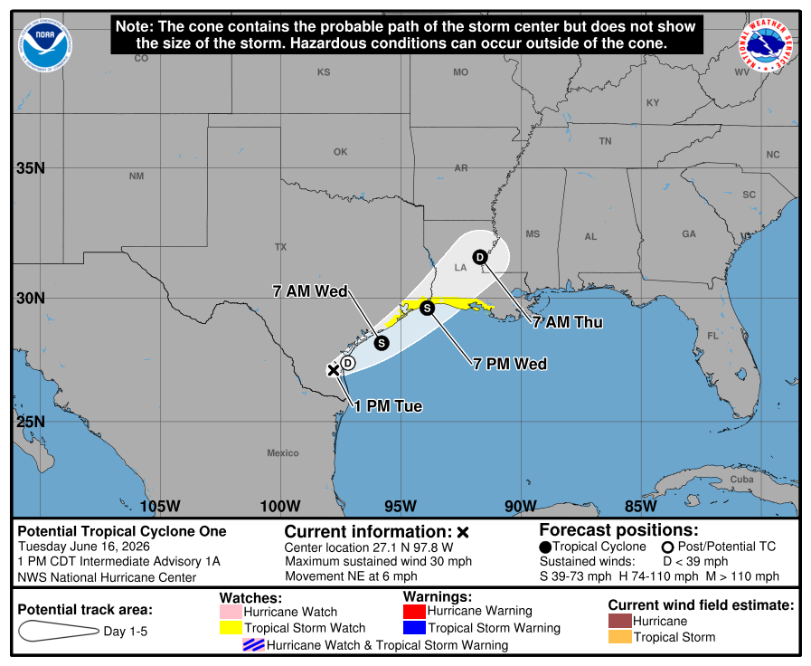
BULLETIN
Potential Tropical Cyclone One Advisory Number 3
NWS National Hurricane Center Miami FL AL012026
1000 PM CDT Tue Jun 16 2026
...SYSTEM NEAR THE TEXAS COAST...
...EXPECTED TO CAUSE LIFE-THREATENING FLOODING TO PORTIONS OF TEXAS
AND LOUISIANA...
SUMMARY OF 1000 PM CDT...0300 UTC...INFORMATION
-----------------------------------------------
LOCATION...27.6N 97.1W
ABOUT 25 MI...35 KM SE OF CORPUS CHRISTI TEXAS
ABOUT 290 MI...470 KM SW OF LAKE CHARLES LOUISIANA
MAXIMUM SUSTAINED WINDS...30 MPH...45 KM/H
PRESENT MOVEMENT...NE OR 50 DEGREES AT 6 MPH...9 KM/H
MINIMUM CENTRAL PRESSURE...1004 MB...29.65 INCHES
WATCHES AND WARNINGS
--------------------
CHANGES WITH THIS ADVISORY:
None.
SUMMARY OF WATCHES AND WARNINGS IN EFFECT:
A Tropical Storm Warning is in effect for...
* Sabine Pass to Morgan City
A Tropical Storm Watch is in effect for...
* Sargent to Sabine Pass
A Tropical Storm Warning means that tropical storm conditions are
expected within the warning area, in this case within 24 hours.
A Tropical Storm Watch means that tropical storm conditions are
possible within the watch area, in this case within 12-24 hours.
For storm information specific to your area, including possible
inland watches and warnings, please monitor products issued by your
local National Weather Service forecast office.
DISCUSSION AND OUTLOOK
----------------------
At 1000 PM CDT (0300 UTC), the disturbance was centered near
latitude 27.6 North, longitude 97.1 West. The system is moving
toward the northeast near 6 mph (9 km/h), and this general motion
with an increase in forward speed is expected over the next couple
of days. On the forecast track, the disturbance should move farther
offshore of the Texas coast overnight, and move roughly parallel to
the upper Texas coast on Wednesday. The system is expected to move
back inland over extreme eastern Texas or southwestern Louisiana
Wednesday night.
Maximum sustained winds are near 30 mph (45 km/h) with higher gusts.
The disturbance is forecast to gradually strengthen and could become
a tropical storm early on Wednesday. Weakening is anticipated on
Thursday after the system moves back over land.
* Formation chance through 48 hours...high...70 percent.
* Formation chance through 7 days...high...70 percent.
The estimated minimum central pressure is 1004 mb (29.65 inches).
HAZARDS AFFECTING LAND
----------------------
Key messages for Potential Tropical Cyclone One can be found in the
Tropical Cyclone Discussion under AWIPS header MIATCDAT1 and WMO
header WTNT41 KNHC.
RAINFALL: Potential Tropical Cyclone One is expected to produce
rainfall totals of 5 to 10 inches, with isolated higher totals near
20 inches, through Thursday from the Mid and Upper Texas coast
east-northeast into southern and central portions of Louisiana,
Mississippi, and Alabama, along with western portions of Georgia and
the Florida Panhandle. This could generate dangerous to
life-threatening flash flooding.
For a complete depiction of forecast rainfall associated with
Potential Tropical Cyclone One, please see the National Weather
Service Storm Total Rainfall Graphic available at
https://t.co/ZQpREEfdnD and the Flash Flood Risk
graphic at https://t.co/9JDyHh5SOG.
For a list of rainfall observations (and wind reports) associated
with this potential tropical cyclone, see the companion storm
summary at WBCSCCNS1 with the WMO header ACUS44 KWBC or at the
following link: https://t.co/ZSYo0EdqdR.
WIND: Tropical storm conditions are possible within the watch
area beginning early Wednesday, and are expected within the warning
area beginning later on Wednesday.
STORM SURGE: The combination of a dangerous storm surge and the
tide will cause normally dry areas near the coast to be flooded by
rising waters moving inland from the shoreline. The water could
reach the following heights above ground somewhere in the indicated
areas if the peak surge occurs at the time of high tide...
Port Bolivar, TX to Morgan City, LA...2-4 ft
The deepest water will occur along the immediate coast near and to
the east of the landfall location, where the surge will be
accompanied by large and dangerous waves. Surge-related flooding
depends on the relative timing of the surge and the tidal cycle,
and can vary greatly over short distances. For information
specific to your area, please see products issued by your local
National Weather Service forecast office.
For a complete depiction of areas at risk of storm surge inundation,
please see the National Weather Service Peak Storm Surge Graphic,
available at https://t.co/S5H6Qu0Ht5.
SURF: Swells generated by the Potential Tropical Cyclone are
likely to cause life-threatening surf and rip current conditions
along the northwestern Gulf Coast for the next couple of days.
Please consult products from your local weather office.
A depiction of rip current risk for the United States can be found
at: https://t.co/vmRzAvl6fT
TORNADO: A tornado or two is possible tonight through Wednesday
night from the Upper Texas Coast into southern Louisiana,
Mississippi, Alabama, and the western Florida Panhandle.
NEXT ADVISORY
-------------
Next intermediate advisory at 100 AM CDT.
Next complete advisory at 400 AM CDT.
$$
Forecaster Pasch/Adams
#WeatherReadyNation #WRN #SKYWARN #CANWARN #Hamradio #AmateurRadio #SATERN #HurricaneHams #TXwx #LAwx #MSwx
BULLETIN
Potential Tropical Cyclone One Intermediate Advisory Number 2A
NWS National Hurricane Center Miami FL AL012026
700 PM CDT Tue Jun 16 2026
...LIFE-THREATENING FLOODING LIKELY OVER PORTIONS OF TEXAS AND
LOUISIANA FROM POTENTIAL TROPICAL CYCLONE ONE....
SUMMARY OF 700 PM CDT...0000 UTC...INFORMATION
----------------------------------------------
LOCATION...27.6N 97.3W
ABOUT 15 MI...25 KM SSE OF CORPUS CHRISTI TEXAS
ABOUT 300 MI...485 KM SW OF LAKE CHARLES LOUISIANA
MAXIMUM SUSTAINED WINDS...30 MPH...45 KM/H
PRESENT MOVEMENT...NE OR 45 DEGREES AT 6 MPH...9 KM/H
MINIMUM CENTRAL PRESSURE...1004 MB...29.65 INCHES
WATCHES AND WARNINGS
--------------------
CHANGES WITH THIS ADVISORY:
None.
SUMMARY OF WATCHES AND WARNINGS IN EFFECT:
A Tropical Storm Warning is in effect for...
* Sabine Pass to Morgan City
A Tropical Storm Watch is in effect for...
* Sargent to Sabine Pass
A Tropical Storm Warning means that tropical storm conditions are
expected within the warning area, in this case within 24 hours.
A Tropical Storm Watch means that tropical storm conditions are
possible within the watch area, in this case within 12-24 hours.
For storm information specific to your area, including possible
inland watches and warnings, please monitor products issued by your
local National Weather Service forecast office.
DISCUSSION AND OUTLOOK
----------------------
At 700 PM CDT (0000 UTC), the disturbance was centered near latitude
27.6 North, longitude 97.3 West. The system is moving toward the
northeast near 6 mph (9 km/h), and this general motion with an
increase in forward speed is expected over the next couple of days.
The disturbance should move offshore the Texas coast in a few hours,
move roughly parallel to the upper Texas coast on Wednesday and move
back inland in extreme eastern Texas or southwestern Louisiana late
Wednesday or early Thursday.
Maximum sustained winds are near 30 mph (45 km/h) with higher gusts.
The disturbance is forecast to gradually strengthen and could become
a tropical storm early on Wednesday. Weakening is anticipated on
Thursday after the system moves back over land.
* Formation chance through 48 hours...high...70 percent.
* Formation chance through 7 days...high...70 percent.
The estimated minimum central pressure is 1004 mb (29.65 inches).
HAZARDS AFFECTING LAND
----------------------
Key messages for Potential Tropical Cyclone One can be found in the
Tropical Cyclone Discussion under AWIPS header MIATCDAT1 and WMO
header WTNT41 KNHC.
RAINFALL: Potential Tropical Cyclone One is expected to produce
rainfall totals of 5 to 10 inches, with isolated higher totals near
20 inches, through Thursday from the Mid and Upper Texas coast
east-northeast into southern and central portions of Louisiana,
Mississippi, and Alabama, along with western portions of Georgia and
the Florida Panhandle. This could generate dangerous to
life-threatening flash flooding.
For a complete depiction of forecast rainfall associated with
Potential Tropical Cyclone One, please see the National Weather
Service Storm Total Rainfall Graphic available at
https://t.co/ZQpREEfdnD and the Flash Flood Risk
graphic at https://t.co/9JDyHh5SOG
For a list of rainfall observations (and wind reports) associated
this potential tropical cyclone, see the companion storm summary at
WBCSCCNS1 with the WMO header ACUS44 KWBC or at the following link:
https://t.co/ZSYo0EdqdR
WIND: Tropical storm conditions are possible within the watch
area beginning early Wednesday, and are expected within the warning
area beginning on Wednesday morning.
STORM SURGE: The combination of a dangerous storm surge and the
tide will cause normally dry areas near the coast to be flooded by
rising waters moving inland from the shoreline. The water could
reach the following heights above ground somewhere in the indicated
areas if the peak surge occurs at the time of high tide...
Port Bolivar, TX to Morgan City, LA...2-4 ft
The deepest water will occur along the immediate coast near and to
the east of the landfall location, where the surge will be
accompanied by large and dangerous waves. Surge-related flooding
depends on the relative timing of the surge and the tidal cycle,
and can vary greatly over short distances. For information
specific to your area, please see products issued by your local
National Weather Service forecast office.
For a complete depiction of areas at risk of storm surge inundation,
please see the National Weather Service Peak Storm Surge Graphic,
available at https://t.co/S5H6Qu0Ht5.
SURF: Swells generated by the Potential Tropical Cyclone are
likely to cause life-threatening surf and rip current conditions
along the northwestern Gulf Coast for the next couple of days.
Please consult products from your local weather office.
A depiction of rip current risk for the United States can be found
at:
https://t.co/vmRzAvl6fT
TORNADO: A tornado or two is possible tonight and tomorrow from the
Upper Texas coast across southern Louisiana, Mississippi, Alabama
and the Florida Panhandle.
NEXT ADVISORY
-------------
Next complete advisory at 1000 PM CDT.
$$
Forecaster Pasch
#WeatherReadyNation #WRN #SKYWARN #CANWARN #Hamradio #AmateurRadio #SATERN #HurricaneHams #TXwx #LAwx #MSwx
BULLETIN
Potential Tropical Cyclone One Advisory Number 2
NWS National Hurricane Center Miami FL AL012026
400 PM CDT Tue Jun 16 2026
...DANGEROUS FLASH FLOODING CONTINUES OVER PORTIONS OF TEXAS AND
LOUISIANA FROM POTENTIAL TROPICAL CYCLONE ONE....
...TROPICAL STORM WARNING ISSUED FOR PORTIONS OF THE LOUISIANA
COAST...
SUMMARY OF 400 PM CDT...2100 UTC...INFORMATION
----------------------------------------------
LOCATION...27.3N 97.6W
ABOUT 35 MI...60 KM SSW OF CORPUS CHRISTI TEXAS
ABOUT 330 MI...530 KM SW OF LAKE CHARLES LOUISIANA
MAXIMUM SUSTAINED WINDS...30 MPH...45 KM/H
PRESENT MOVEMENT...NE OR 45 DEGREES AT 6 MPH...9 KM/H
MINIMUM CENTRAL PRESSURE...1005 MB...29.68 INCHES
WATCHES AND WARNINGS
--------------------
CHANGES WITH THIS ADVISORY:
A Tropical Storm Warning is issued for the coast of Louisiana from
Sabine Pass to Morgan City.
SUMMARY OF WATCHES AND WARNINGS IN EFFECT:
A Tropical Storm Warning is in effect for...
* Sabine Pass to Morgan City
A Tropical Storm Watch is in effect for...
* Sargent to Sabine Pass
A Tropical Storm Warning means that tropical storm conditions are
expected within the warning area, in this case within 24 hours.
A Tropical Storm Watch means that tropical storm conditions are
possible within the watch area, in this case within 12-24 hours.
For storm information specific to your area, including possible
inland watches and warnings, please monitor products issued by your
local National Weather Service forecast office.
DISCUSSION AND OUTLOOK
----------------------
At 400 PM CDT (2100 UTC), the disturbance was centered near latitude
27.3 North, longitude 97.6 West. The system is moving toward the
northeast near 6 mph (9 km/h), and this general motion with an
increase in forward speed is anticipated over the next couple of
days. The disturbance should move offshore the Texas coast tonight,
move roughly parallel to the upper Texas coast on Wednesday and
move back inland in extreme eastern Texas or southwestern Louisiana
late Wednesday or early Thursday.
Maximum sustained winds remain near 30 mph (45 km/h) with higher
gusts. The disturbance is forecast to gradually strengthen and
could become a tropical storm early on Wednesday. Weakening is
anticipated on Thursday after the system moves back over land.
* Formation chance through 48 hours...high...70 percent.
* Formation chance through 7 days...high...70 percent.
The estimated minimum central pressure is 1005 mb (29.68 inches).
HAZARDS AFFECTING LAND
----------------------
Key messages for Potential Tropical Cyclone One can be found in the
Tropical Cyclone Discussion under AWIPS header MIATCDAT1 and WMO
header WTNT41 KNHC.
RAINFALL: Potential Tropical Cyclone One is expected to produce
rainfall totals of 5 to 10 inches, with isolated higher totals near
20 inches, through Thursday from the Mid and Upper Texas coast
east-northeast into southern and central portions of Louisiana,
Mississippi, and Alabama, along with western portions of Georgia and
the Florida Panhandle. This could generate dangerous to
life-threatening flash flooding.
For a complete depiction of forecast rainfall associated with
Potential Tropical Cyclone One, please see the National Weather
Service Storm Total Rainfall Graphic available at
https://t.co/ZQpREEfdnD and the Flash Flood Risk
graphic at https://t.co/9JDyHh5SOG
For a list of rainfall observations (and wind reports) associated
this potential tropical cyclone, see the companion storm summary at
WBCSCCNS1 with the WMO header ACUS44 KWBC or at the following link:
https://t.co/ZSYo0EdqdR
WIND: Tropical storm conditions are possible within the watch
area beginning early Wednesday and within the warning area on
Wednesday morning.
STORM SURGE: The combination of a dangerous storm surge and the
tide will cause normally dry areas near the coast to be flooded by
rising waters moving inland from the shoreline. The water could
reach the following heights above ground somewhere in the indicated
areas if the peak surge occurs at the time of high tide...
Port Bolivar, TX to Morgan City, LA...2-4 ft
The deepest water will occur along the immediate coast near and to
the east of the landfall location, where the surge will be
accompanied by large and dangerous waves. Surge-related flooding
depends on the relative timing of the surge and the tidal cycle,
and can vary greatly over short distances. For information
specific to your area, please see products issued by your local
National Weather Service forecast office.
For a complete depiction of areas at risk of storm surge
inundation, please see the National Weather Service Peak
Storm Surge Graphic, available at
https://t.co/S5H6Qu0Ht5.
SURF: Swells generated by the Potential Tropical Cyclone are
likely to cause life-threatening surf and rip current conditions
along the northwestern Gulf Coast for the next couple of days.
Please consult products from your local weather office.
A depiction of rip current risk for the United States can be found
at:
https://t.co/vmRzAvl6fT
TORNADO: A tornado or two is possible tonight and tomorrow from the
Upper Texas coast across southern Louisiana, Mississippi, Alabama
and the Florida Panhandle.
NEXT ADVISORY
-------------
Next intermediate advisory at 700 PM CDT.
Next complete advisory at 1000 PM CDT.
$$
Forecaster Blake
#WeatherReadyNation #WRN #SKYWARN #CANWARN #Hamradio #AmateurRadio #SATERN #HurricaneHams #TXwx #LAwx #MSwx
BULLETIN
Potential Tropical Cyclone One Intermediate Advisory Number 1A
NWS National Hurricane Center Miami FL AL012026
100 PM CDT Tue Jun 16 2026
...DANGEROUS FLASH FLOODING OCCURING OVER PORTIONS OF TEXAS AND
LOUISIANA FROM POTENTIAL TROPICAL CYCLONE ONE....
SUMMARY OF 100 PM CDT...1800 UTC...INFORMATION
----------------------------------------------
LOCATION...27.1N 97.8W
ABOUT 55 MI...85 KM SSW OF CORPUS CHRISTI TEXAS
ABOUT 345 MI...560 KM SW OF LAKE CHARLES LOUISIANA
MAXIMUM SUSTAINED WINDS...30 MPH...45 KM/H
PRESENT MOVEMENT...NE OR 45 DEGREES AT 6 MPH...9 KM/H
MINIMUM CENTRAL PRESSURE...1006 MB...29.71 INCHES
WATCHES AND WARNINGS
--------------------
CHANGES WITH THIS ADVISORY:
None
SUMMARY OF WATCHES AND WARNINGS IN EFFECT:
A Tropical Storm Watch is in effect for...
* Sargent to Morgan City
A Tropical Storm Watch means that tropical storm conditions are
possible within the watch area, in this case within 24 to 36 hours.
For storm information specific to your area, including possible
inland watches and warnings, please monitor products issued by your
local National Weather Service forecast office.
DISCUSSION AND OUTLOOK
----------------------
At 100 PM CDT (1800 UTC), the disturbance was centered near latitude
27.1 North, longitude 97.8 West. The system is moving toward the
northeast near 6 mph (9 km/h), and this general motion with an
increase in forward speed is anticipated over the next couple of
days. The disturbance should move offshore the Texas coast tonight
or early Wednesday, move roughly parallel to the upper Texas coast
later on Wednesday and move back inland in extreme eastern Texas or
southwestern Louisiana late Wednesday or early Thursday.
Maximum sustained winds remain near 30 mph (45 km/h) with higher
gusts. The disturbance is forecast to gradually strengthen and
could become a tropical storm early on Wednesday. Weakening is
anticipated on Thursday after the system moves back on land.
* Formation chance through 48 hours...high...70 percent.
* Formation chance through 7 days...high...70 percent.
The estimated minimum central pressure is 1006 mb (29.71 inches).
HAZARDS AFFECTING LAND
----------------------
Key messages for Potential Tropical Cyclone One can be found in the
Tropical Cyclone Discussion under AWIPS header MIATCDAT1 and WMO
header WTNT41 KNHC.
RAINFALL: Potential Tropical Cyclone One is expected to produce
rainfall totals of 4 to 8 inches with isolated higher totals around
12 inches through Thursday from the Mid to Upper Texas Coast through
much of Louisiana, central and southern portions of Mississippi and
Alabama, and the far western portion of the Florida Panhandle. This
could generate dangerous to life-threatening flash flooding.
For a complete depiction of forecast rainfall associated with
Potential Tropical Cyclone One, please see the National Weather
Service Storm Total Rainfall Graphic available at
https://t.co/ZQpREEfdnD and the Flash Flood Risk
graphic at https://t.co/9JDyHh5SOG
For a list of rainfall observations (and wind reports) associated
this potential tropical cyclone, see the companion storm summary at
WBCSCCNS1 with the WMO header ACUS44 KWBC or at the following link:
https://t.co/ZSYo0EdqdR
WIND: Tropical storm conditions are possible within the watch
area beginning early Wednesday.
STORM SURGE: The combination of a dangerous storm surge and the
tide will cause normally dry areas near the coast to be flooded by
rising waters moving inland from the shoreline. The water could
reach the following heights above ground somewhere in the indicated
areas if the peak surge occurs at the time of high tide...
Port Bolivar, TX to Morgan City, LA...2-4 ft
The deepest water will occur along the immediate coast near and to
the east of the landfall location, where the surge will be
accompanied by large and dangerous waves. Surge-related flooding
depends on the relative timing of the surge and the tidal cycle,
and can vary greatly over short distances. For information
specific to your area, please see products issued by your local
National Weather Service forecast office.
For a complete depiction of areas at risk of storm surge
inundation, please see the National Weather Service Peak
Storm Surge Graphic, available at
https://t.co/S5H6Qu0Ht5.
SURF: Swells generated by the Potential Tropical Cyclone are
likely to cause life-threatening surf and rip current conditions
along the northwestern Gulf Coast for the next couple of days.
Please consult products from your local weather office.
A depiction of rip current risk for the United States can be found
at:
https://t.co/vmRzAvl6fT
TORNADO: A tornado or two is possible through tonight from the
Upper Texas coast across southern Louisiana, Mississippi, Alabama
and the Florida Panhandle.
NEXT ADVISORY
-------------
Next complete advisory at 400 PM CDT.
$$
Forecaster Blake
#WeatherReadyNation #WRN #SKYWARN #CANWARN #Hamradio #AmateurRadio #SATERN #HurricaneHams #TXwx #LAwx #MSwx
Tropical Weather Outlook
NWS National Hurricane Center Miami FL
200 PM EDT Tue Jun 16 2026
For the North Atlantic...Caribbean Sea and the Gulf of America:
Active Systems:
The National Hurricane Center is issuing advisories on Potential
Tropical Cyclone One, located over south Texas.
* Formation chance through 48 hours...high...70 percent.
* Formation chance through 7 days...high...70 percent.
&&
Public Advisories on Potential Tropical Cyclone One are issued
under WMO header WTNT31 KNHC and under AWIPS header MIATCPAT1.
Forecast/Advisories on Potential Tropical Cyclone One are issued
under WMO header WTNT21 KNHC and under AWIPS header MIATCMAT1.
$$
Forecaster Blake
#WeatherReadyNation #WRN #SKYWARN #CANWARN #Hamradio #AmateurRadio #SATERN #HurricaneHams
BULLETIN
Potential Tropical Cyclone One Advisory Number 1
NWS National Hurricane Center Miami FL AL012026
1000 AM CDT Tue Jun 16 2026
...VERY HEAVY RAINFALL AND DANGEROUS FLASH FLOODING EXPECTED FROM
POTENTIAL TROPICAL CYCLONE ONE....
SUMMARY OF 1000 AM CDT...1500 UTC...INFORMATION
-----------------------------------------------
LOCATION...27.0N 98.0W
ABOUT 65 MI...105 KM SW OF CORPUS CHRISTI TEXAS
ABOUT 360 MI...580 KM SW OF LAKE CHARLES LOUISIANA
MAXIMUM SUSTAINED WINDS...30 MPH...45 KM/H
PRESENT MOVEMENT...NE OR 45 DEGREES AT 6 MPH...9 KM/H
MINIMUM CENTRAL PRESSURE...1007 MB...29.74 INCHES
WATCHES AND WARNINGS
--------------------
CHANGES WITH THIS ADVISORY:
A Tropical Storm Watch has been issued for the northwestern
Gulf Coast from Sargent, Texas to Morgan City, Louisiana.
SUMMARY OF WATCHES AND WARNINGS IN EFFECT:
A Tropical Storm Watch is in effect for...
* Sargent to Morgan City
A Tropical Storm Watch means that tropical storm conditions are
possible within the watch area, in this case within 24 to 36 hours.
For storm information specific to your area, including possible
inland watches and warnings, please monitor products issued by your
local National Weather Service forecast office.
DISCUSSION AND OUTLOOK
----------------------
At 1000 AM CDT (1500 UTC), the disturbance was centered near
latitude 27.0 North, longitude 98.0 West. The system is moving
toward the northeast near 6 mph (9 km/h), and this general motion
with an increase in forward speed is anticipated over the next
couple of days. The disturbance should move offshore the Texas
coast tonight or early Wednesday, move roughly parallel to the upper
Texas coast later on Wednesday and move back inland in extreme
eastern Texas or southwestern Louisiana late Wednesday or early
Thursday.
Maximum sustained winds are near 30 mph (45 km/h) with higher gusts.
The disturbance is forecast to gradually strengthen and could become
a tropical storm early on Wednesday. Weakening is anticipated on
Thursday after the system moves back on land.
* Formation chance through 48 hours...medium...60 percent.
* Formation chance through 7 days...medium...60 percent.
The estimated minimum central pressure is 1007 mb (29.74 inches).
HAZARDS AFFECTING LAND
----------------------
Key messages for Potential Tropical Cyclone One can be found in the
Tropical Cyclone Discussion under AWIPS header MIATCDAT1 and WMO
header WTNT41 KNHC.
RAINFALL: Potential Tropical Cyclone One is expected to produce
rainfall totals of 4 to 8 inches with isolated higher totals around
12 inches through Thursday from the Mid to Upper Texas Coast through
much of Louisiana, central and southern portions of Mississippi and
Alabama, and the far western portion of the Florida Panhandle. This
could generate dangerous to life-threatening flash flooding.
For a complete depiction of forecast rainfall associated with
Potential Tropical Cyclone One, please see the National Weather
Service Storm Total Rainfall Graphic available at
https://t.co/ZQpREEfdnD and the Flash Flood Risk
graphic at https://t.co/9JDyHh5SOG
For a list of rainfall observations (and wind reports) associated
this potential tropical cyclone, see the companion storm summary at
WBCSCCNS1 with the WMO header ACUS44 KWBC or at the following link:
https://t.co/ZSYo0EdqdR
WIND: Tropical storm conditions are possible within the watch
area beginning early Wednesday.
STORM SURGE: The combination of a dangerous storm surge and the
tide will cause normally dry areas near the coast to be flooded by
rising waters moving inland from the shoreline. The water could
reach the following heights above ground somewhere in the indicated
areas if the peak surge occurs at the time of high tide...
Port Bolivar, TX to Morgan City, LA...2-4 ft
The deepest water will occur along the immediate coast near and to
the east of the landfall location, where the surge will be
accompanied by large and dangerous waves. Surge-related flooding
depends on the relative timing of the surge and the tidal cycle,
and can vary greatly over short distances. For information
specific to your area, please see products issued by your local
National Weather Service forecast office.
For a complete depiction of areas at risk of storm surge
inundation, please see the National Weather Service Peak
Storm Surge Graphic, available at
https://t.co/S5H6Qu0Ht5.
SURF: Swells generated by the Potential Tropical Cyclone are
likely to cause life-threatening surf and rip current conditions
along the northwestern Gulf Coast for the next couple of days.
Please consult products from your local weather office.
A depiction of rip current risk for the United States can be found
at:
https://t.co/vmRzAvl6fT
TORNADO: A tornado or two is possible through tonight from the
Upper Texas coast across southern Louisiana, Mississippi, Alabama
and the Florida Panhandle.
NEXT ADVISORY
-------------
Next intermediate advisory at 100 PM CDT.
Next complete advisory at 400 PM CDT.
$$
Forecaster Blake
#WeatherReadyNation #WRN #SKYWARN #CANWARN #Hamradio #AmateurRadio #SATERN #HurricaneHams