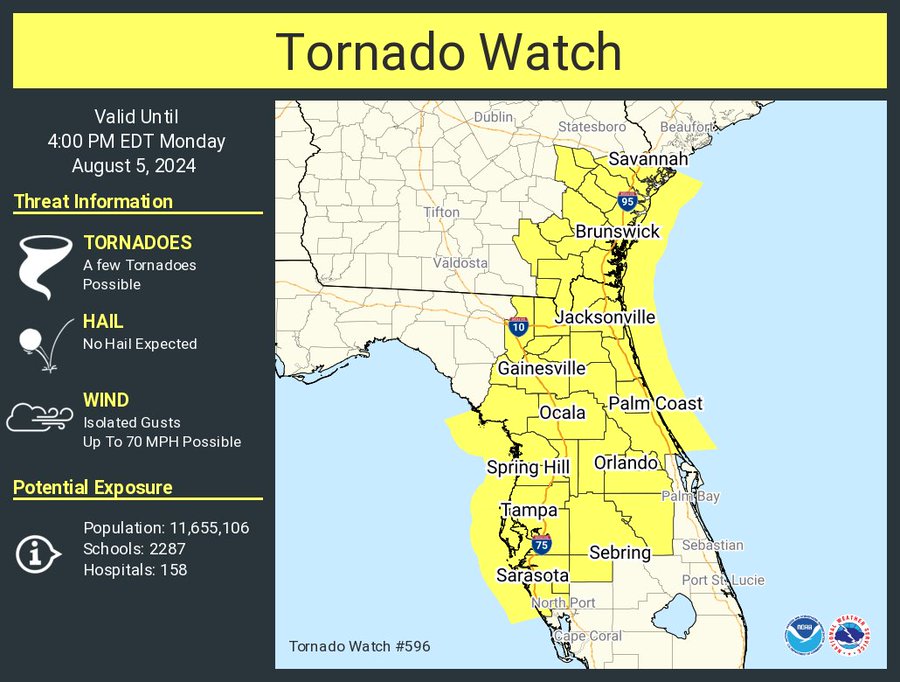
CEMA Alert: A Tornado Watch has been issued for Chatham County until 4 PM today. Additional hazards include isolated wind gusts up to 70 mph are possible. Please continue to monitor alerts for updated information.
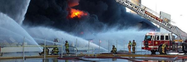
#BREAKING Multiple Alarm response to large industrial fire at Marine Terminal. One tank explosion at wood chip conveyor facility. Scene ongoing. #savannah#fire
Sunrise in Savannah 🔅
We're proud to announce our affiliation with the NHL's @FlaPanthers and AHL's @CheckersHockey Hockey Club ! #Timetohaunt 👻
More info here | https://t.co/MtQqdAR1ED
𝐁𝐑𝐄𝐀𝐊𝐈𝐍𝐆: The Stanley Cup® is coming to Savannah!
The 131-year-old trophy will be displayed at several locations during the 2024 Warrior/ECHL All-Star Classic, presented by @GulfstreamAero!
📰 https://t.co/cjips09n9T
Engines 4, 13, and Hazmat 2 are en route to Glynn County to assist with the Symrise Chemical Plant fire. News reports are that the fire is burning uncontrollably and many explosions have occurred. Several residential areas are being evacuated. #glynncountyga
Last night: Marine 1 (Engine 3) and Rescue 1 along with other units responded to Houlihan Bridge in Port Wentworth for a capsized boat. Units found 1 victim floating on top of the boat. A rescue swimmer from Rescue 1 was deployed and safely recovered the victim, who was unharmed.
#BREAKING: Engines 2, 10, 11, Truck 2, Rescue 2, Safety 1, HazMat 2, Battalion Chief 2 on scene of a #structurefire on Hollandpark Cir. Heavy flames from the rear of the house upon arrival. E2 and 10 on attack. Truck 2 with search.
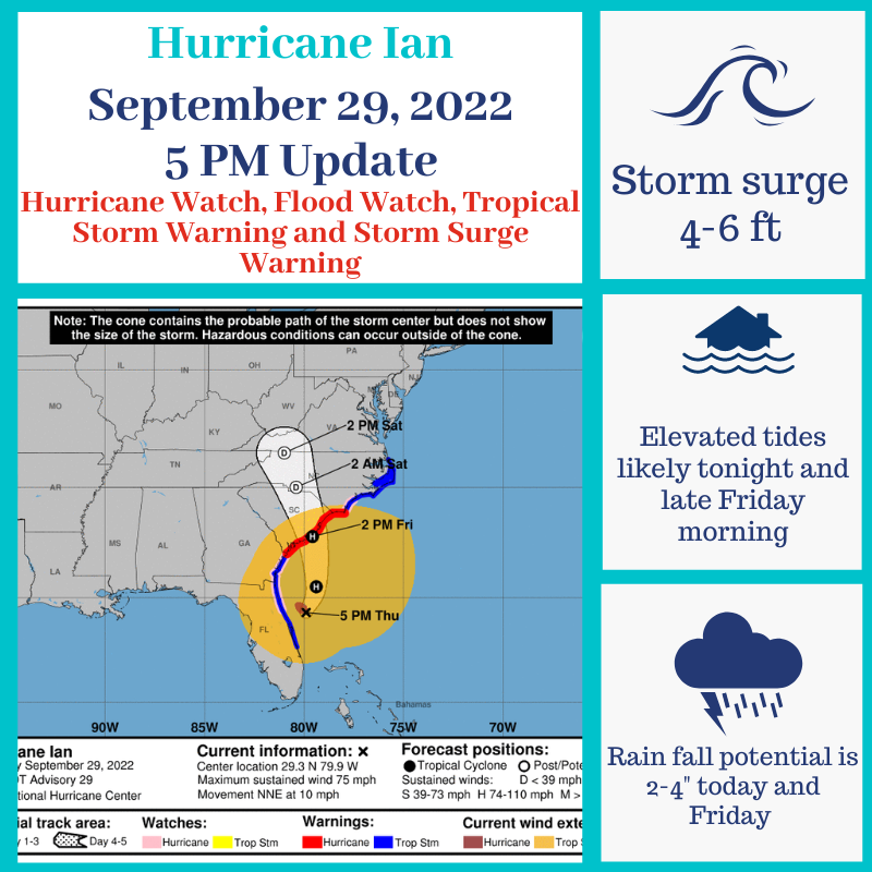
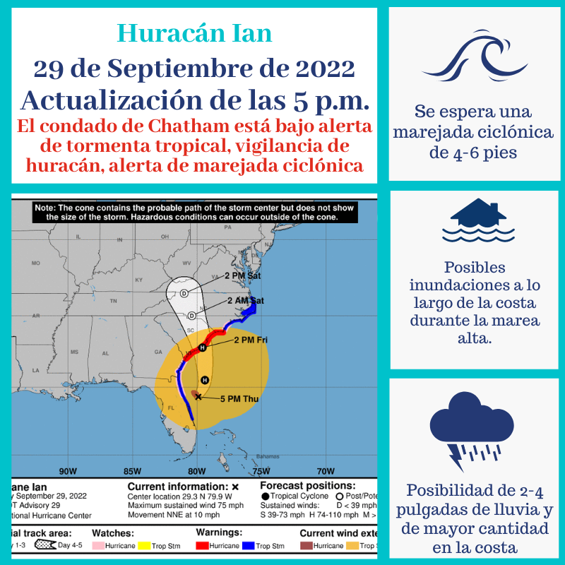
Ian has re-strengthened into a Category 1 Hurricane, but track has shifted farther east. Chatham remains under a Hurricane and Flood Watch, TS and Storm Surge Warning. Potential impacts are gusty winds, 2-4” of rain, storm surge 4-6 feet, and coastal flooding. #HurricaneIan
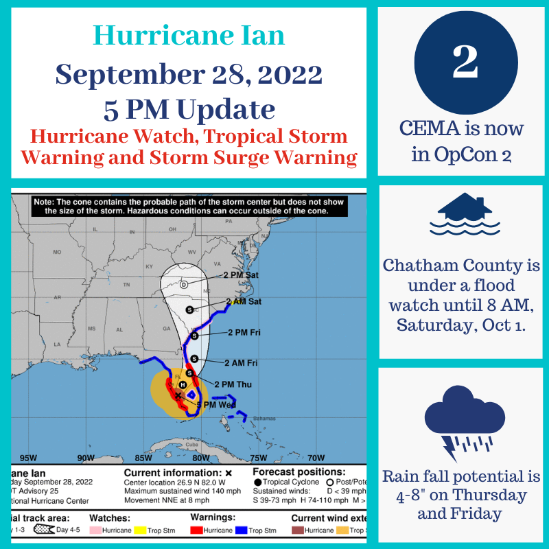
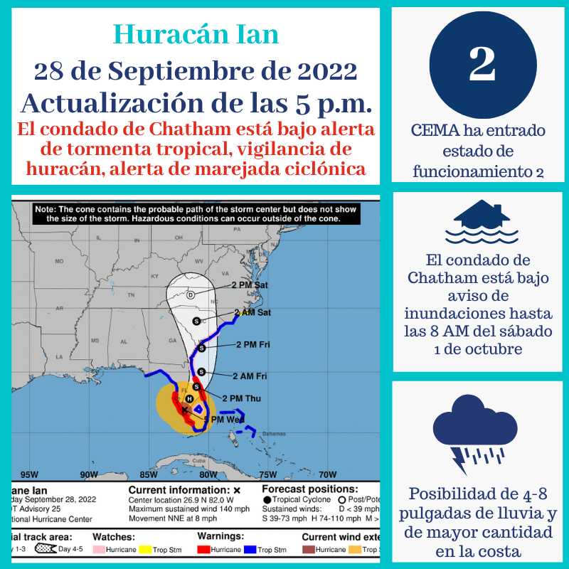
We are under a Flood Watch until 8 AM Oct 1, Hurricane Watch, Tropical Storm Warning and a Storm Surge Warning. Expect impacts Thursday into Friday. Potential impacts are gusty winds, tornadoes, 4-8” of rain, elevated tides, and coastal flooding. Visit: https://t.co/q5jx7ILWPR
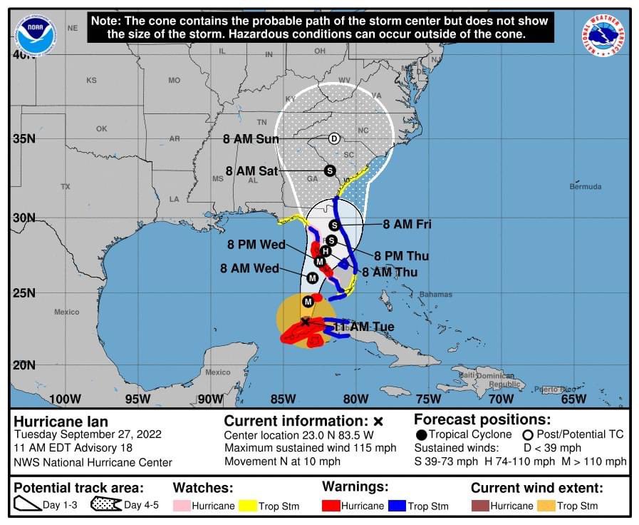
This is the latest #hurricaneian track for the 11am advisory. The coastal area of #savannah is now under a tropical storm warning, storm surge warning, and hurricane watch! Be prepared and stay safe! #iaff574
Here is the latest track on Hurricane Ian. This brings tropical storm conditions to our area Friday and Saturday. If you haven’t prepared, please do so now. Expect heavy rains, gusty winds, and the possibility of tornadoes and flooding. #hurricaneian#iaff#iaffsafetytips
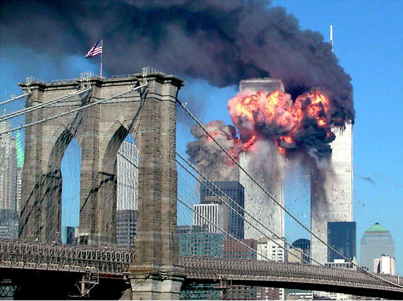
L574 will never forget the 343 FDNY members and the almost 3000 others who lost their lives during the worst terrorist attack in American history. We will always remember the families of our fallen, including the members who have succumbed to World Trade Center related illnesses.
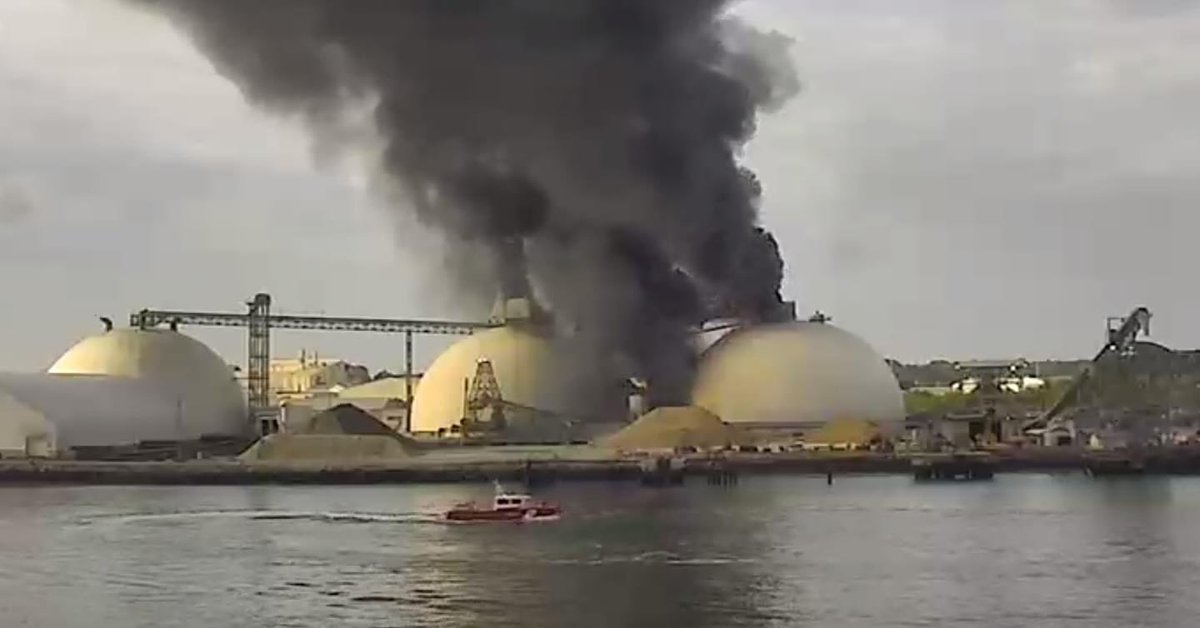
#BREAKING: 2 Alarm Fire 🚨. 136 Marine Terminal Dr. E9, E1, E5, E3, E8, E13, R1, R2, T5, T1, Marine 1, SAF 1, BC1, BC2, HM2, REHAB 1. Fire due to conveyor belt spread to the building and contents. Flames impinging on diesel fuel tanks above and under ground.
#BREAKING Structure fire 37th and skidaway. Abandon residential home. E8/E9/E5/E1/T1/R1/HM2/SAF1/BC1. E8/E5 fire attack, T1 primary all clear, E9 RIT, E1 secondary all clear.