🎉 Exciting news! Interpine has been named a finalist in the Innovation & Technology category at the Rotorua Business Awards 2026. 🚀
This achievement belongs to our whole team, whose innovation, expertise, and dedication continue to drive new solutions for forestry, environmental monitoring, AI, drones, and geospatial technology.
Proud of our people. Proudly Rotorua. 💚
https://t.co/P0tNyG703r
#RotoruaBusinessAwards #Innovation #Technology #TeamInterpine
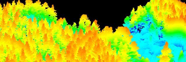
🌲 Explore a #DJI Zenmuse L3 LiDAR dataset yourself.
Fly through an interactive 3D forest point cloud and see the raw data behind modern forest analytics. The viewer includes classified LiDAR data showing terrain and vegetation structure.
🔗 https://t.co/qY8XhWozsH
Part 1 of 2.
Later this week we'll show how TreeTools SilvaCloud and SilvaCloud Live transforms the same dataset into operational forest inventory assessments. Follow along to find out more.
#LiDAR #DJI #Forestry #GIS #TreeTools #SilvaCloud
See pest pressure before it costs you, and impacts your new forest being established.
Thermal + night vision drones are helping map pest density in young forests — enabling targeted control and better establishment outcomes.
Read more:
https://t.co/TBflUAvymY
Monitoring Whio (endangered blue duck) in remote NZ rivers is challenging.
Our BVLOS drone ops and mesh networking extend survey reach, capturing high-quality data with minimal disturbance.
Learn more: https://t.co/bAeaeYLnzU
🌲 New cost saving insight from LiDAR for forestry operations
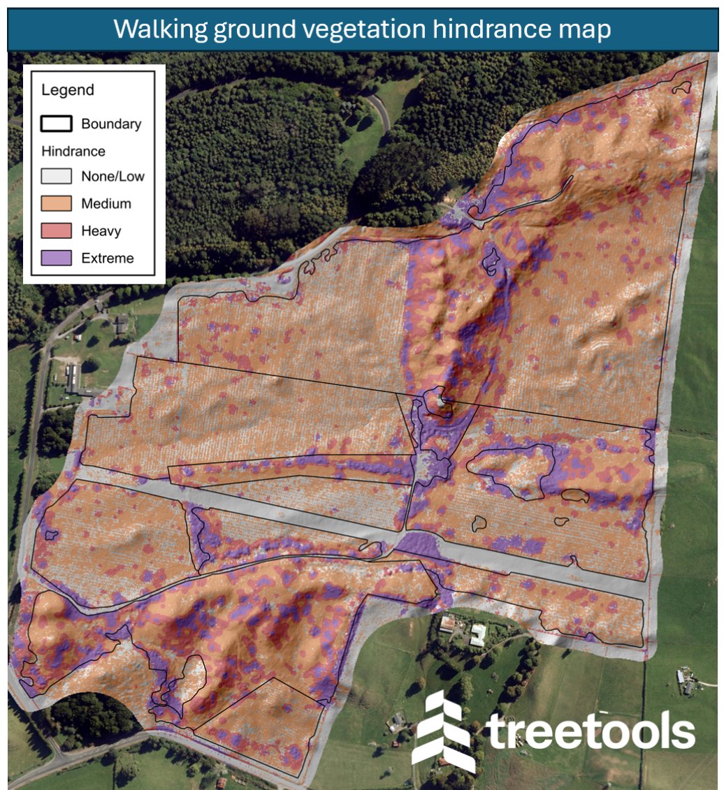
Understanding how easy (or difficult) it is to move through a forest stand has always been important—but hard to quantify.
Our latest article shows how LiDAR can be used to map walking hindrance, turning vegetation density into a practical layer for planning and decision-making.
Read more: https://t.co/ZjPXD37ehE
Forestry teams have always understood that how easy a stand is to move through has a real impact on field productivity, safety, and cost — but until now, it has been difficult to measure consistently at scale.
By identifying where movement is open, slowed, or heavily restricted, these maps can help with smarter crew deployment, better route planning, improved health and safety, and a clearer understanding of why operational costs vary from stand to stand.
Interpine’s TreeTools Silva Cloud now makes it possible to generate these hindrance maps directly from your LiDAR data.
If you’re looking to reduce wasted time in the field, improve operational visibility, and support more data-driven forestry decisions, this is well worth a look.
#Forestry #LiDAR #RemoteSensing #TreeTools #SilvaCloud
📷📷 New in Virtual Plot: Chemical Thinning (eThinning) AI – ALPHA Release
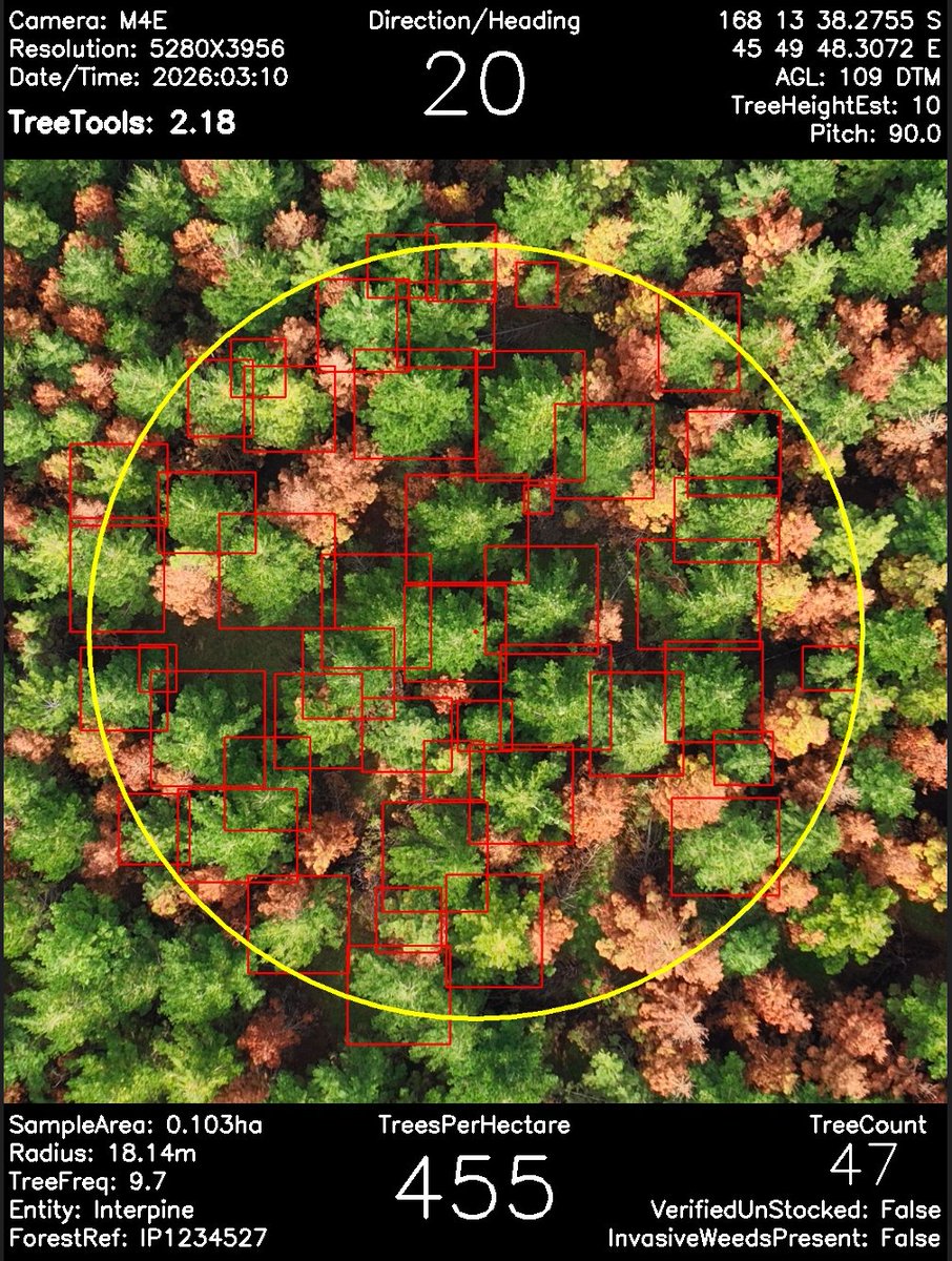
We’ve just released an ALPHA Chemical Thinning (eThinning) AI model in https://t.co/PnJ7AeQsNC Virtual Plot, supporting rapid post‑treatment stocking assessment using drone imagery.
Designed to detect remaining crop trees and distinguish them from chemically thinned stems showing stress or dieback, this new capability helps foresters evaluate the success of eThinning operations — particularly in steep or hard‑to‑access terrain.
This release is part of our collaboration with NZ Forest Growers Research – Precision Silviculture, and we’re inviting users to trial the model, share feedback, and help improve it using real‑world forestry data.
📷 Read the full article and learn how to get involved:
https://t.co/OlX99Q7gx7
#PrecisionSilviculture #ChemicalThinning #eThinning #DigitalForestry #AIinForestry #VirtualPlot #Interpine
🌲🚁 Power your forest inventory surveys with DJI and TreeTools Virtual Plot. Maximise your value, tightly integrated AI drone-to-decision solution in field and offline.
Interpine is combining DJI Enterprise drone technology with our Virtual Plot forest inventory software to help forestry teams capture better data and turn it into real insight — faster.
As an authorised DJI reseller, we’re offering 50% off Virtual Plot when you purchase a DJI Matrice 4E Combo 2 through Interpine.
👉 Read more about the offer and how it can support your operations: https://t.co/8qukhlkm4A
#ForestryInnovation #DigitalForestry #VirtualPlot #ForestSurveys #DJI #DJIEnterprise
🌲 Using Computer Vision to Measure Log Volumes in the Log Yard 🤖📏
Accurately measuring log volumes in operational log yards is a long‑standing challenge for the forestry sector. As part of a postgraduate research project, Ethan Clapham (University of Exeter) explored whether modern computer vision and AI techniques could provide a practical, scalable alternative to traditional log scaling methods.
Working alongside the Interpine team, the project tested an image‑based approach using real log yard imagery captured during forestry operations. The research demonstrates how automated detection and geometric modelling can estimate log diameters and volumes directly from photographs — even under challenging real‑world conditions such as occlusion and variable lighting.
We were pleased to support this work by contributing real‑world data and industry expertise in log scaling and applied AI, helping bridge the gap between academic research and operational forestry.
👉 Read the full article and view the research poster here: https://t.co/e6q0sgRZQF
#ForestryInnovation #ComputerVision #AIinForestry #DigitalForestry #LogScaling #ResearchInAction
🏃♀️🏃♂️ Interpine Whānau on the Move – Rotorua Marathon Weekend!
This weekend, several of our Interpine whānau are lacing up their running shoes and taking on the Rotorua Marathon. It’s fantastic to see members of the team putting their fitness to the test and embracing the challenge.
Alongside our runners, Interpine is also proud to be supporting the Kids’ Mini Marathon, helping encourage the next generation to get active and enjoy the buzz of this iconic Rotorua event.
Health and wellbeing are an important foundation for both productivity and enjoyment at work, and it’s great to see so many of the team taking this opportunity to get out there, stay active, and support the wider community.
Best of luck to everyone involved this weekend — we’ll be cheering you on! 👏💚
DJI L2 vs L3 LiDAR: What the Upgrade Means in the Forest 🌲🚁
At Interpine, we’re always focused on improving the quality and reliability of our forest data. Our latest analysis compares DJI’s Zenmuse L2 and L3 LiDAR sensors, flown over the same Pinus radiata stand under identical conditions, to see how the new generation performs in real forestry environments.
The results were clear.
✅ More consistent point density across complex terrain
✅ Significantly improved canopy penetration and ground detection
✅ Cleaner, more reliable terrain models with fewer data gaps
✅ Much greater tree��level detail, including branch‑scale structure
While the L2 remains effective in simpler terrain, the L3 delivered uniform coverage and high‑quality data even on steep, variable ground and under dense canopy. This consistency reduces re‑flights, post‑processing effort, and uncertainty in downstream forest inventory outputs.
For forestry projects where terrain complexity and data confidence matter, the L3 represents a meaningful step forward in drone‑based LiDAR capability.
👉 Read the full technical comparison here:
https://t.co/8I5xgfLcIL
Interpine's drone pilots undergo rigorous annual external operational competency assessments, demonstrating their expertise and enabling the expansion of capabilities under CAA Part 102, including operations such as beyond visual line of sight, nighttime flights, high-altitude missions, and more, all while maintaining stringent adherence to health and safety protocols. It is gratifying to witness the team's successful completion of airspace refreshers and flight exams.
Drone-based LiDAR is transforming how we measure and understand our forests. It’s one of the fastest and most effective ways to collect detailed forest inventory and planning data.
From small woodlots to full forest estates, Interpine’s combination of modern LiDAR sensors, beyond‑line‑of‑sight drone operations, and advanced communication systems sets our team apart as sector leaders.
Paired with our SilvaCloud and https://t.co/PnJ7AeQsNC analysis suite, we deliver fast, accurate, and scalable insights—making our end‑to‑end capability second to none.
TreeTools SilvaCloud https://t.co/J21CppuX4X
Interpine Drone LiDAR Services https://t.co/lM5RRQkvmp
New Software Update: Virtual Plot Professional v2.15
It’s been a busy month for the TreeTools team, and we��re excited to share another significant update to Virtual Plot Professional. You can now conduct forest inventory stocking plots with your drone more efficiently than ever—powered by the latest advances in artificial intelligence.
What’s New in Version 2.15?
Target Stocking & Tolerance Reporting
Set your target stocking levels and tolerance ranges to receive clear, effective reporting on the percentage of plots that fall under, on, or over your target.
Enhanced Manual Refinement
Add meaningful context to each plot by tagging “verified unstocked” or “invasive weed issue”. These additional insights help strengthen both reporting accuracy and on‑ground forest management decisions.
Start Your AI Tree Detection Model Labelling Now
Don’t yet have an AI model trained for your tree species? No problem. Simply choose not to apply any existing AI models, and Virtual Plot will still calibrate your imagery and generate virtual plots ready for your own manual labelling using the REFINE tool. Once you’ve completed your labelled dataset, reach out to the team and share your project folder, and our team can assess it for training a new species‑specific model to add to Virtual Plot.
👉 Explore the new tutorial and start leveraging AI for smarter forest inventory today:
https://t.co/R95BY2NHXg
👉 Try it out for as little as $38/month.
https://t.co/V8gxh7iNbj
New Software Update: TreeTools Virtual Plot Professional v2.13
We’re excited to announce the latest update for TreeTools Virtual Plot Professional! Start conducting forest inventory stocking plots with your drone today using the power of artificial intelligence.
📷 Check out our new “Getting Started” tutorial for version 2.13 of Virtual Plot – designed to help you hit the ground running.
https://t.co/EyW8u2uFPg
What’s New in Version 2.13?
Direct KMZ Uploads: Google KMZ files now upload straight into Avenza Maps, making it easy to view plots on your mobile device in the forest or share with contractors.
Custom Plot Sizes: Define your own plot size for greater flexibility.
Stand Area Definition: Provide a shape file to define your stand boundary – only plots within the boundary are analysed and included in results.
Enhanced AI Models:
- Radiata Pine age 1–2 and 3–4 pre-assessment inventory.
Post-thinning detection models for improved accuracy.
- Hardwood Regeneration Assessment (Preview): Compliant with NSW CIFOA Protocol 37 for regeneration and stocking monitoring plots.
📷 Explore the new tutorial and start leveraging AI for smarter forest inventory today!
https://t.co/R95BY2NHXg
Extending Drone Capabilities: Interpine’s BVLOS Advantage
Beyond Line-of-Sight Operations Certification
At Interpine Innovation, we’re proud to operate under CAA Part 102 Certification, enabling us to fly drones Beyond Visual Line of Sight (BVLOS). This capability is a game-changer for our clients and the wider forestry and environmental sectors.
Why BVLOS Matters?
BVLOS operations allow drones to cover greater distances and access remote or hazardous areas without the limitations of maintaining direct visual contact. For our clients, this means:
Expanded Coverage: Survey large-scale forests, river systems, and infrastructure in a single flight.
Improved Efficiency: Reduce time and cost by minimising manual intervention and multiple take-off points.
Enhanced Safety: Keep crews out of dangerous terrain while still capturing critical data.
Leading with Innovation and Safety
Interpine continues to set the benchmark for safe, innovative drone solutions. Our BVLOS capability is backed by rigorous risk assessments, advanced navigation systems, and compliance with Civil Aviation Authority standards. This ensures every mission is not only efficient but also meets the highest safety requirements.
Driving the Future of Drone Technology
By extending the operational range of drones, we continue to unlock new possibilities for AI-driven analytics, environmental monitoring, and precision forestry. BVLOS is more than a certification—it’s a commitment to helping our clients achieve smarter, safer, and more sustainable outcomes.
Minister Profiles Drone Technology and AI for Biosecurity Success
At Interpine Innovation, we’re proud to have partnered in a groundbreaking trial that is transforming how New Zealand tackles one of its most persistent agricultural challenges: bovine tuberculosis (TB).
The government recently launched a trial in Central Otago to control possum populations—the primary carriers of bovine TB—using advanced drone technology combined with AI-driven detection systems. This initiative, led by OSPRI and supported by Biosecurity Minister Andrew Hoggard, represents a major step forward in eradicating the disease from cattle and deer herds.
Our Role in the Project
Interpine Innovation provided the drone operations and AI expertise that made this trial possible. By integrating thermal imaging, night vision and intelligent detection algorithms, our systems enabled teams to: Access remote, rugged terrain safely and efficiently, Detect possum populations, Pinpoint locations for targeted ground operations.
This approach reduces manual effort, accelerates decision-making, and ensures resources are deployed where they have the greatest impact.
Why It Matters
Bovine TB has long been a costly and stressful issue for farmers, with historical outbreaks causing significant economic and emotional strain. By leveraging technology, we’re helping to close the chapter on this disease and safeguard New Zealand’s farming future.
Looking Ahead
This trial is more than a technical achievement—it’s a proof point for how AI and drone technology can revolutionise biosecurity and environmental management. Interpine Innovation remains committed to pushing the boundaries of what’s possible in forestry, agriculture, and sustainability.
https://t.co/Uk7XUoSuYc
https://t.co/TjHpQevsx2
https://t.co/3eZMcJaQ1K
Big congratulations to the team!
It’s fantastic to see our work in large-scale AI detection recognised in these nation awards. We’re proud to have played a part in supporting the project to identify large woody debris across the Tairāwhiti region.
https://t.co/ydJGKFKGwt