@newheightshow I’ve been listening back on the show and hit @JasonKelce’s retirement episode, and the way the two of you express emotion and show love is such healthy masculinity and is awesome to see! Keep showing young men how to do it!
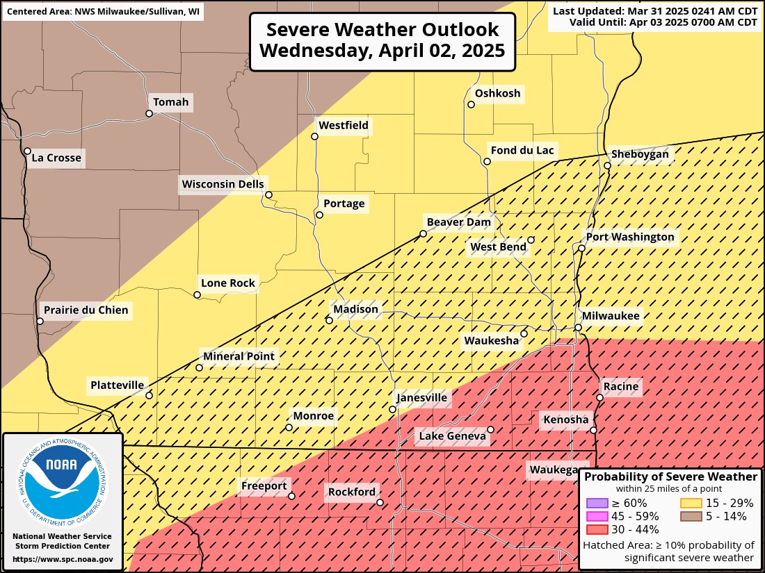
Waukesha County is generally in a level 2 of 5 risk for severe weather for Wednesday, with a level 3 of 5 risk in the Muskego area. The entire county is also in a 'hatched' risk for an increased chance for significant severe weather. As of now, this is currently our highest severe threat so far this year.
Uncertainty is very high, and there are numerous failure modes in play that could very well cause this threat to not materialize. The primary failure mode is rain/non-severe storms in the morning cause the environment to not destabilize in the afternoon for the severe round of storms.
*IF* the severe threat were to materialize properly, all hazards would be possible including the chance for significant wind gusts (75+ mph) and the chance for a strong tornado (EF2+). Again, uncertainty is high and this entire set up could come crashing down and fail to initiate in a matter of just a few hours. Updates will be provided.
Severe Weather Update:
Nearly all of Waukesha County has been upgraded to a level 2 of 5 severe risk.
With the newest model data, it appears a line of strong to severe storms will most likely impact the area sometime between 9pm and 12am Friday night. The earlier the storms hit in that range, the more instability that will be available to intensify storms.
There remains timing differences in the models but regardless of that, all models are consistent with that line of storms hitting our area and producing widespread strong winds gust of at least 45-55 MPH. An isolated tornado or two is also possible.
The biggest question for severity is primarily the timing, but also if storms end up "gusting out" or not. If a gust front races ahead of the actual line of storms, the strength of the storms will decrease very quickly. Gusty winds would still be possible from them 'gusting out' but typically when that happens wind gusts stay below severe limits and remain around the 30-40 MPH range.
More updates will come as needed.
As spring gets closer, that also means severe weather season is getting closer. Practice severe weather safety with your family and have plans ready in the event of a tornado. It is recommended to have a weather radio for severe weather alerts. Waukesha Alerts will also automatically post severe weather alerts as they are issued.
With that being said, it appears our first chance for severe weather might be coming up around March 15th (ish). While we are still a week away, the entire chance could very easily fall apart at anytime. Weather can be complicated, and severe weather requires many different ingredients coming together at the same time and can sometimes be somewhat unpredictable.
Some weather models have shown some consistency with the chance around March 15th, and because of the surprising amount of consistency this far out (for now) it can’t be ignored.
It appears timing will play a major factor in this possible event, and that is one of the things that is NOT consistent with weather models at this time. The models are consistent for the time being with having some sort of line of storms form to our west and move east into our area at some point during that time.
It also indicates a chance to develop a decent amount of instability for this time of year, leading to a chance of seeing severe weather primarily in the form of wind. However, models are also indicating the chance for some tornado producing ingredients coming together leading to the potential to see a low end tornado chance during this time. The exact timing will ultimately be the #1 deciding factor for this.
Take this with a grain of salt for now, as this very well could fall apart as soon as tomorrow and end up not happening. But consistency is one of the primary things that is looked for in terms of predicting future severe weather events. And as of now, we have that consistency.
We remain in a level 3 of 5 severe risk for this evening. Isolated storms with strong tornadoes will likely form far west of our area and eventually congeal into a line of severe storms.
Main threat is widespread damaging winds of 65 to 80 MPH. A few tornadoes are also possible embedded within the line.
There are still some slight uncertainties but overall there is a high chance of severe storms to occur tonight.
Timing will likely be around 8 PM to 11 PM, depending on how quickly the line moves once it forms.
Did we just create the perfect lineup? 👀 Aug 7–12👇
🥇 VANILLA CRUMB CAKE FT. GOLDEN OREO®
💕🍩 PINK DOUGHNUT
🥜 BUCKEYE BROWNIE
🧈 KENTUCKY BUTTER CAKE
🍋 LEMON BAR
🍪 SEMI-SWEET CHOCOLATE CHUNK
GOLDEN OREO® is a trademark of Mondelēz International group, used under license.