🌪️ TORNADO HISTORY SERIES COMPLETED: This summer, I've researched and shared in-depth summaries of 11 significant historical tornadoes in North Dakota and eastern Montana. Here is a compilation of all my Morse Code of Weather and feature segments: https://t.co/AykUPNBEgu
The trend of a snowy winter for populated places continues!
Across the United States, about 52 percent of people (168 million) have experienced above-average snowfall — while 34 percent of the country's land area has had above-average snowfall.
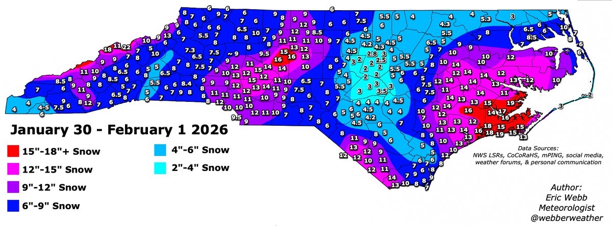
Here's my preliminary analysis for this weekend's snowstorm over North Carolina.
This storm will be one for the record books in a lot of NC.
Hopefully, I'll be able to find some time later this week to look at South Carolina.
Thanks for all the reports everyone
#ncwx
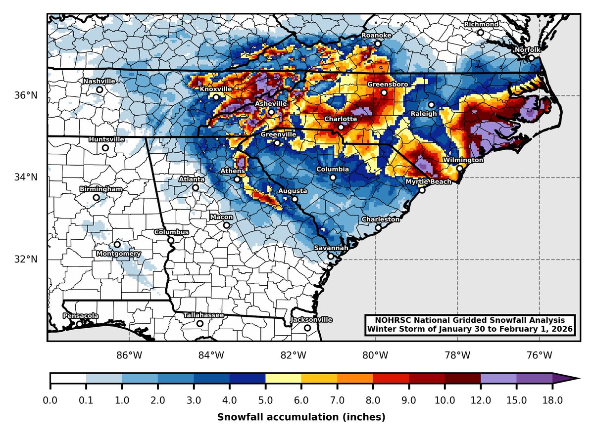
Here it is! I put together this map showing the storm total snowfall accumulation for the recent winter storm. The data used is based on the National Operational Hydrologic Remote Sensing Center's (NOHRSC) National Gridded Snowfall Analysis. Please share!
Here is a sneak leak into some of the more “plain language” that we plan to use to communicate these evolving threats.
The entire scope of this is hard to explain on a X thread or webpage which is why we are pointing people to upcoming training seminars and YouTube videos.
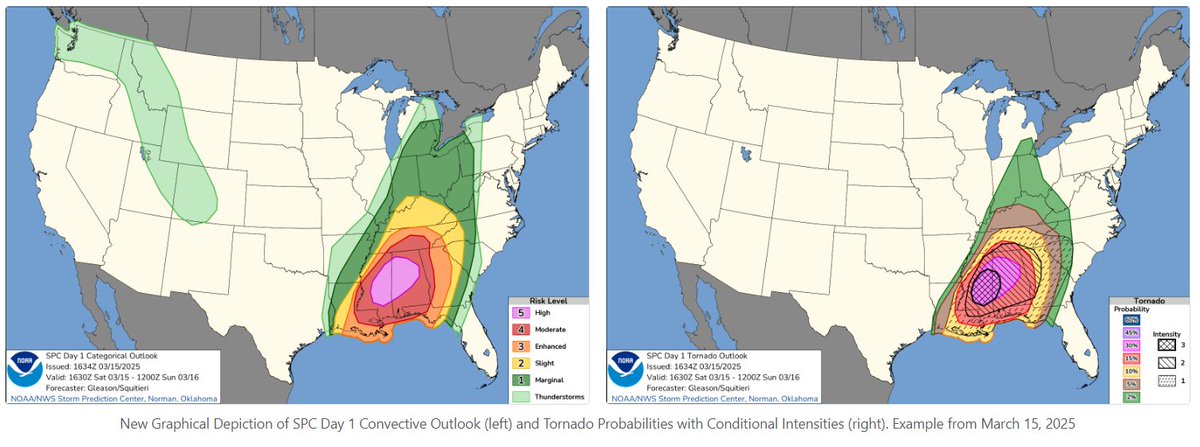
Big changes are coming to Storm Prediction Center Convective Outlooks on or around March 2!
-Introduction of three different types of hatching for significant severe weather, corresponding to increasing intensity of potential hazards
-Addition of 75 and 90% wind contours
Read more about the upcoming changes here: https://t.co/vhDAWf0ZyK
What are your thoughts? Might get to work on a video discussing these changes in detail and how to interpret them.
🧵SPC will be introducing new information in Convective Outlooks starting in early March. The following thread will offer some basic information regarding these changes. The TL;DR: outlook categories are not changing! But there will be more info for peak hazard intensity.
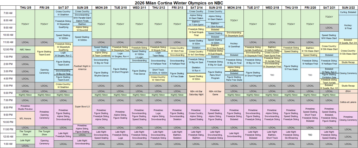
Full preliminary schedule of 2026 Olympic coverage on NBC. Everything subject to change.
LIVE events in blue, taped coverage in yellow.
USA Network will also have 24/7 coverage, with all events streaming live and on demand on Peacock.
Big win for Penn State football today in the Pinstripe Bowl! #WeAre
The commentators were complaining about the cold in NYC... THIS is actual cold here in the Northern Plains!
I'll be talking about the wind chill forecast and MUCH more winter weather on @KFYRTV this evening!
So I was wondering if Denver was in for their warmest December on RECORD... and @wxmattjones delievered. Not only is Denver number 1 thus far, but so is Albuquerque, Boise, Seattle, Portland, Salt Lake City, Las Vegas among dozens of others across the entire west.
I have tried and failed for a decade to capture this view in #Pittsburgh, and this morning I was finally able to. In this scene, the Duquesne Incline passes above the train tracks right as a Norfolk Southern train was going underneath it. Can't believe my luck that it worked out.
More/better Hurricane Melissa videos now that the furlough/gov shutdown is over and I can get the go ahead to post revised versions. What was originally posted three weeks ago were quick edits/crops exported in 720p which were good enough but not all that they could be. I will include a link to YT so those inclined can watch in 4K. Today I’m posting thread from pass 5 which was approx 1645-1648Z time.
This first one is GoPro Max footage that I finally got around to editing. It starts very similar to the post from a few weeks ago but with a twist. 1/5
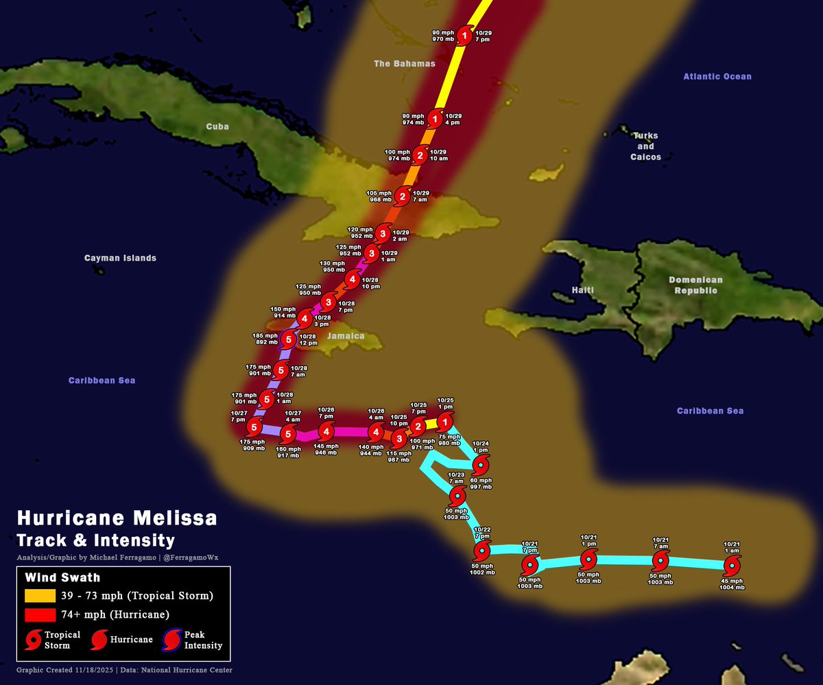
I created a detailed track and intensity map for Hurricane #MELISSA, displaying categories, date/times, and wind swaths for the storm.
Visible is MELISSA's slow start over the Eastern Caribbean Sea. It was named on the morning of 10/21, and took a few days to organize due to constant wind shear. It became a hurricane on the afternoon of 10/25, and soon underwent rapid intensification, becoming a Category 4 by the morning of 10/26.
MELISSA's intensification was paused temporarily before becoming a Category 5 early on 10/27. The storm fluctuated in intensity as a Category 5 before peaking in intensity around noon on 10/28. It would strike #Jamaica around the same time.
Land interaction with Jamaica severely disrupted MELISSA's core, weakening it to a Category 3 once exiting the island later on 10/28. It fluctuated in intensity once more while moving northeast, becoming a Category 4 briefly, then back to a 3. It made its second landfall in the Santiago de Cuba province with winds of 120 mph.
MELISSA would weaken once more as it exited Cuba, making additional landfalls in The Bahamas as a Category 1 hurricane on 10/29. It restrengthened into a Category 2 further north over the Atlantic, and was last noted passing west of Bermuda as a minimal hurricane.
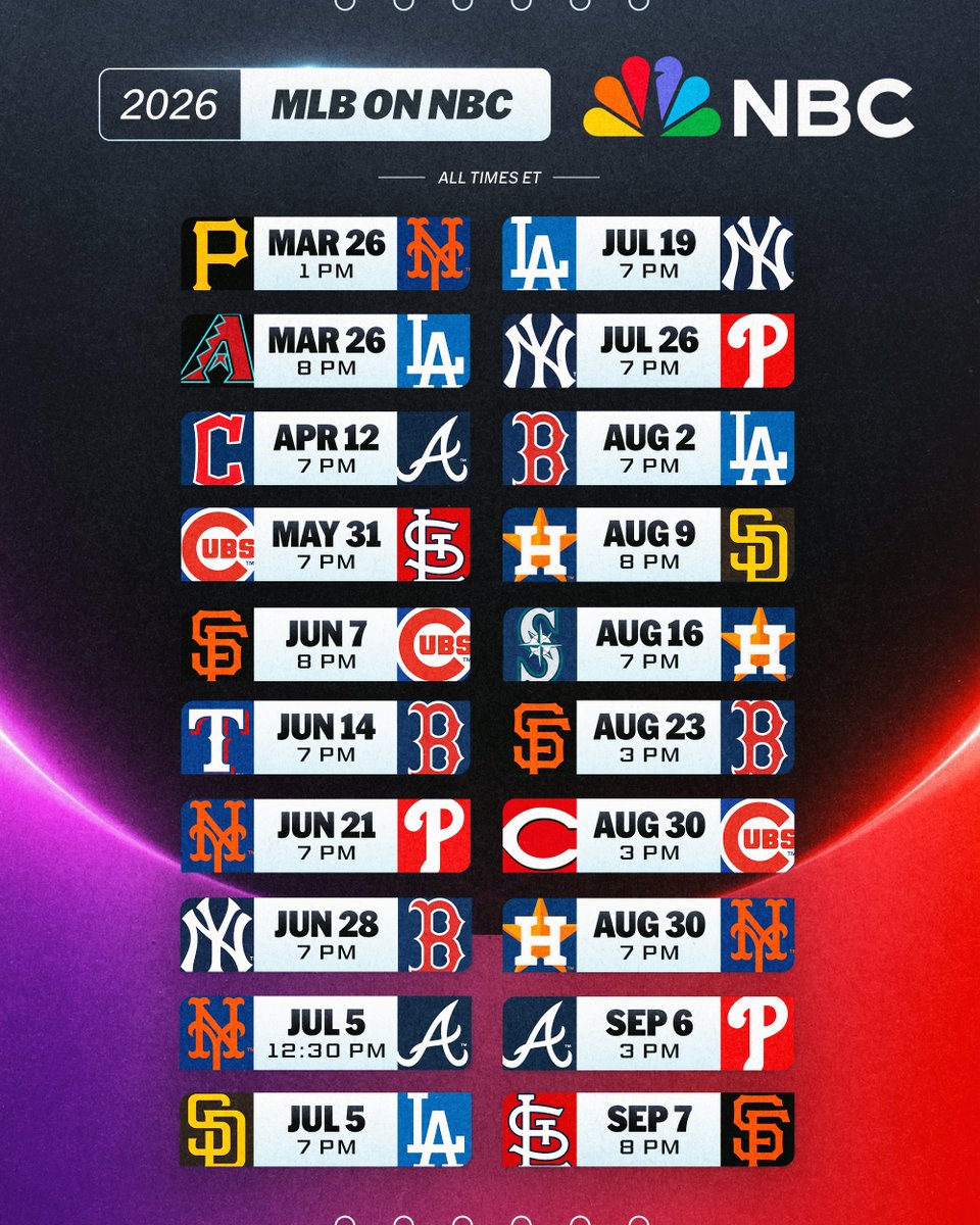
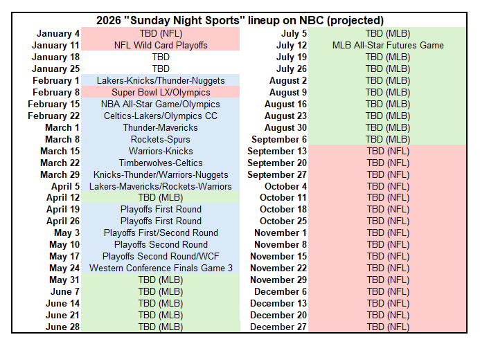
Baseball is BACK on NBC and streaming on Peacock! ⚾️
It all starts March 26 in Los Angeles when the Dodgers raise their 2025 World Series championship banner.
Learn more: https://t.co/tej7PEc7WK