Mainly dry, cool and cloudy this evening, just an isolated rain shower early then partial clearing. Chilly later tonight into the morning with lows falling to the mid to upper 30s. More details on Ch. 2 News this evening, and at https://t.co/3qlNPAVop2
A fantastic evening with warmth and sunshine! Then rain moves in late evening, also cooler air returns for the rest of the week. More details at https://t.co/3qlNPAVop2
Life Update: The time has come for me to move on and into the next phase of life. I am very grateful for the many years at Ch. 2 and I’m especially thankful to all of you viewers who have supported me over the years! My last day is next Fri. I’ll keep you posted on what’s next!
Rain showers are expected to return Friday night into Saturday morning. Nicer day for Sunday. More details on Channel 2 News and at https://t.co/3qlNPAVop2
Colder conditions last into Tuesday morning with lows in the 20s, then a warming trend for the rest of the week, with some limited rain chances. I’ll have the full forecast this evening on Channel 2 News at 5pm and 6pm on NBC TV.
Details, updates also at https://t.co/WI9kQfAUoW
Wrap up outdoor plans by 3pm today.
Rain is a SURE BET. Scattered thunderstorms may become strong to severe, especially for S.Tier. High in mid 70s, then temps plummet tonight.
Sunday: chilly, mostly cloudy. A lot of dry time, spotty showers arrive PM. Some wintry mix.
~O'Neill
Widespread showers and thunderstorms are expected ahead of a cold front, bringing an elevated threat of severe weather across Western New York this afternoon through this evening. Due to the saturated ground, thunderstorms may result in ponding and isolated flash flooding.
Partly clear and mild for Friday night, then rain and thunderstorms move in later Saturday afternoon into early evening. Chilly for Sunday. More details and updates at https://t.co/3qlNPAVop2
Heavy rain and thunderstorms moving through this evening mainly early, a few stronger storms possible mostly south and inland. More details at https://t.co/3qlNPAVop2
Active weather continues through Saturday. The higher risk for severe thunderstorms this afternoon is further east and northeast compared to yesterday.
For more details on today's severe risk, our latest briefing can be found at: https://t.co/XeUnMAjQJG
Scattered showers and thunderstorms to arrive between 5 PM and 10 PM. The main risk of severe weather will lie across the Southern Tier, well south of I-90. Expect the damaging wind gusts as the primary threat, though a tornado can't be ruled out.
Numerous rounds of showers and thunderstorms will cross the region today through the end of the week, but there will be rain free time each day as well. A few thunderstorms may be severe, mainly late this afternoon and evening and again Thursday afternoon and evening.
On and off showers and thunderstorms are expected over the next few days. Stay weather aware as a few of the thunderstorms through Wednesday could be strong to severe with isolated damaging wind gusts.
More details: https://t.co/DyIwve7965
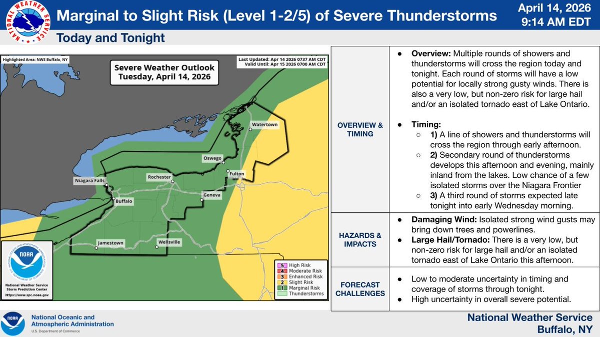
Multiple rounds of showers/storms will cross the region through early Wednesday morning, with each round possibly containing locally strong gusty winds. There is also a very low, but non-zero risk for large hail and/or an isolated tornado east of Lake Ontario this afternoon.
Warming up with scattered rain showers at times into the weekend then cooler for Easter Sunday with plenty of dry time as well over the holiday weekend. Details and updates at https://t.co/3qlNPAVop2