UPGRADE: Portions of southern #Wisconsin near the IL now sit under a #ModerateRisk (4 of 5) for severe weather.
I can’t stress it enough - pay attention to those weather alerts on your phone. They will be very useful this afternoon and evening. #wiwx@SpectrumNews1WI
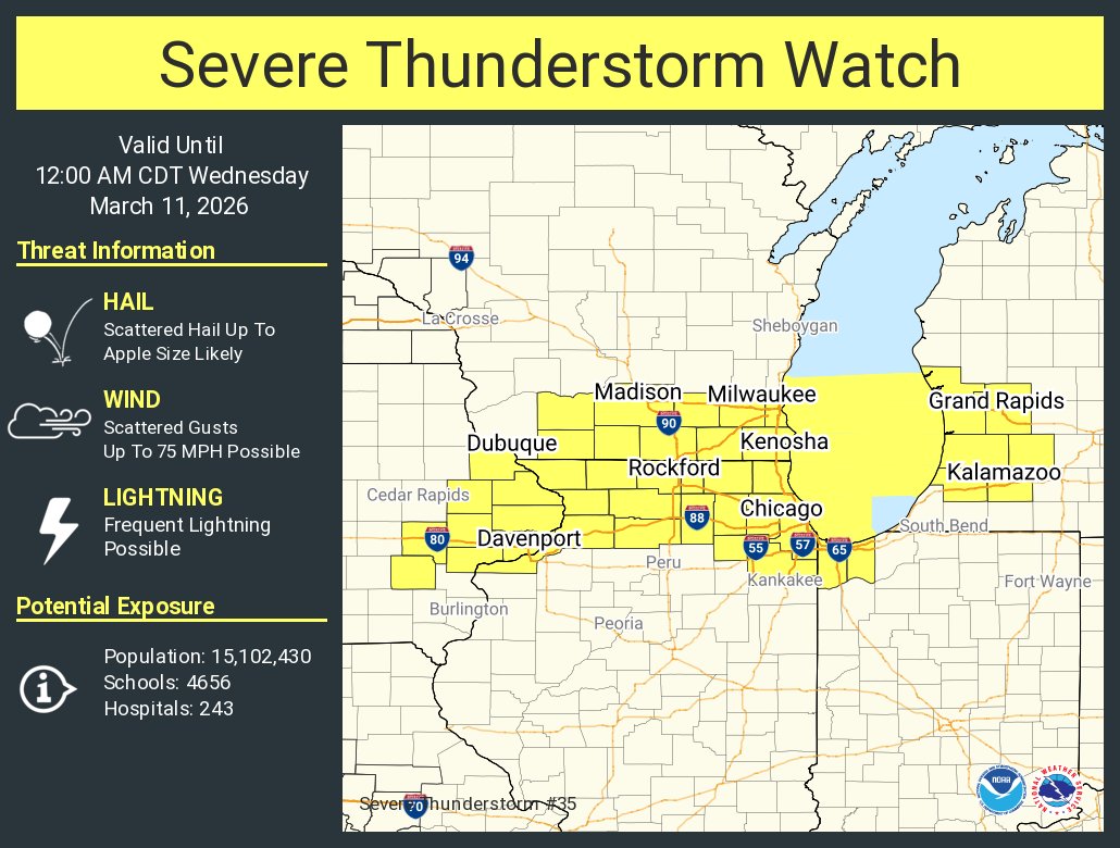
Severe Thunderstorm Watch for a large portion of the state until 7 PM.
Thunderstorms will begin in far southwestern this afternoon and will work eastward by early evening.
#wiwx@SpectrumNews1WI
Watch likely coming out very soon for portions of southwestern #Wisconsin.
Prepare now for severe thunderstorms later today. Storms will be capable of heavy rain, destructive wind, large hail, and isolated tornadoes. #wiwx@SpectrumNews1WI
🚨ALERT🚨
A Tornado Watch will likely be issued for portions of southern and western #Wisconsin shortly.
Now is the time to prepare. Have a game plan for you and your family. Be ready to act in short notice. #wiwx@SpectrumNews1WI
Severe Thunderstorm Watch until 5 PM for portions of NW #Wisconsin.
Ingredients are present for destructive winds, large hail, and a few tornadoes.
Stay alert to warnings and be ready to act in short notice. #wiwx@SpectrumNews1WI
⚠️The area of New London to ~ 8 miles southwest along the Wolf River is being evacuated due to dangerous flood waters. If you are living in the impacted area, and choose to remain in place, your safety cannot be guaranteed- YOU SHOULD
EVACUATE IMMEDIATELY TO ENSURE YOUR SAFETY!
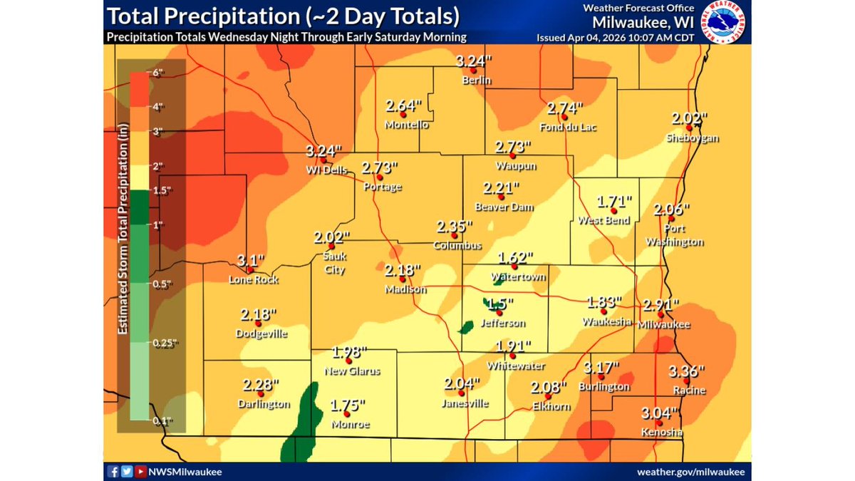
This is a map of total precipitation from Wednesday night through early Saturday morning. The highest amounts are found toward west central WI and in southeast WI. Widespread totals over 1.5 inches with over 4 inches in the highest spots. #wiwx
The threat for severe weather continues to increase across southern #Wisconsin for Thursday. Storms will be capable of producing tornadoes, damaging wind gusts, and hail. Stay alert 🚨


![iembot_mkx's tweet photo. At 4:38 PM CDT, 1 E Mazomanie [Dane Co, WI] Public reports Hail of tennis ball size (M2.50 Inch) #wiwx https://t.co/hLtwKBqELg https://t.co/sjue5fteEf](https://pbs.twimg.com/media/HF5Y2cfXwAAA-3J.jpg)
![iembot_mkx's tweet photo. MKX continues Severe Thunderstorm Warning [wind: 60 MPH (RADAR INDICATED), hail: 1.25 IN (RADAR INDICATED)] for Dane, Iowa [WI] till 5:00 PM CDT https://t.co/sTbtXCN3CC https://t.co/kBTbqzneJY](https://pbs.twimg.com/media/HF5S-ezXwAEuwvR.png)


![iembot_mkx's tweet photo. MKX updates Tornado Watch (expands area to include Columbia, Dane, Dodge, Fond du Lac, Iowa, Jefferson, Kenosha, Milwaukee, Ozaukee, Racine, Sheboygan, Washington, Waukesha [WI], continues Green, Lafayette, Rock, Walworth [WI]) till Apr 2, 8:00 PM CDT https://t.co/N3hI41Z8UJ https://t.co/82T6OGifhi](https://pbs.twimg.com/media/HE7ixHPXEAAP5fI.png)


![iembot_mkx's tweet photo. STRONG THUNDERSTORMS WILL IMPACT SOUTHEASTERN GREEN AND ROCK COUNTIES THROUGH 630 AM CDT [wind: 50 MPH, hail: 0.25 IN] https://t.co/S7Ypo5cpEf https://t.co/jgkTDRXyr4](https://pbs.twimg.com/media/GxGXoCOXMAAwjYy.jpg)


