#EarthquakePH#EarthquakeSamar
Earthquake Information No.1
Date and Time: 18 Dec 2019 - 05:14 PM
Magnitude = 2.1
Depth = 025 kilometers
Location = 11.73N, 125.13E - 008 km N 70° E of Hinabangan (Samar)
https://t.co/XkLL0IQ2JM
#EarthquakePH#EarthquakeNorthernSamar
Earthquake Information No.1
Date and Time: 20 Nov 2019 - 08:32 AM
Magnitude = 3.4
Depth = 037 kilometers
Location = 12.78N, 125.73E - 062 km N 57° E of Mapanas (Northern Samar)
https://t.co/r71NyCr7VJ
#EarthquakePH#EarthquakeEasternSamar
Earthquake Information No.1
Date and Time: 18 Nov 2019 - 12:53 AM
Magnitude = 2.6
Depth = 046 kilometers
Location = 12.17N, 125.31E - 013 km S 30° W of Arteche (Eastern Samar)
https://t.co/wya3uEkByZ
#EarthquakePH#EarthquakeCotabato
Earthquake Information No.1
Date and Time: 13 Nov 2019 - 08:31 AM
Magnitude = 2.0
Depth = 026 kilometers
Location = 06.86N, 124.92E - 010 km N 84° E of Tulunan (Cotabato)
https://t.co/1Ov8jpGyGE
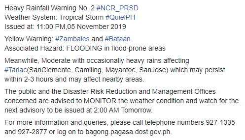
JUST IN: Pumasok na sa loob ng Philippine Area of Responsibility ang Tropical Depression sa may West Southwest ng Iba, Zambales kaninang 8 a.m. Papangalanan itong Bagyong Quiel. Ayon sa PAGASA, maglalabas sila ng Severe Weather Bulletin mamayang 11:00 a.m.
#EarthquakePH#EarthquakeCotabato#iFelt_CotabatoEarthquake
Earthquake Information No.1
Date and Time: 30 Oct 2019 - 08:39 AM
Magnitude = 3.7
Depth = 020 kilometers
Location = 06.86N, 124.95E - 013 km N 86° E of Tulunan (Cotabato)
https://t.co/XrkwAh5KO3
#EarthquakePH#EarthquakeBatangas
Earthquake Information No.1
Date and Time: 27 Oct 2019 - 07:00 PM
Magnitude = 2.5
Depth = 120 kilometers
Location = 13.72N, 120.74E - 016 km N 67° W of Tingloy (Batangas)
https://t.co/FnVPNRMpPT
#EarthquakePH#EarthquakeDavaoOccidental
Earthquake Information No.1
Date and Time: 25 Oct 2019 - 09:37 AM
Magnitude = 2.5
Depth = 134 kilometers
Location = 04.70N, 126.06E - 104 km S 39° E of Sarangani (Davao Occidental)
https://t.co/jJdACMM0J2
#EarthquakePH#EarthquakeDavaoOccidental
Earthquake Information No.1
Date and Time: 24 Oct 2019 - 08:40 AM
Magnitude = 2.3
Depth = 145 kilometers
Location = 06.48N, 125.85E - 027 km N 74° E of Malita (Davao Occidental)
https://t.co/9Hfrq93Hoe
#EarthquakePH#EarthquakeCotabato
Earthquake Information No.1
Date and Time: 21 Oct 2019 - 12:03 AM
Magnitude = 3.0
Depth = 022 kilometers
Location = 06.75N, 124.95E - 018 km S 50° E of Tulunan (Cotabato)
https://t.co/N6fGN0hjsi
#EarthquakePH#EarthquakeCotabato#iFelt_CotabatoEarthquake
Earthquake Information No.1
Date and Time: 20 Oct 2019 - 05:05 PM
Magnitude = 3.7
Depth = 001 kilometers
Location = 06.67N, 124.99E - 026 km S 42° E of Tulunan (Cotabato)
https://t.co/YTK7RN9kFD